Category Archives: Ramsgate

VM_365 Day 293 What’s in the archive box?

VM 293

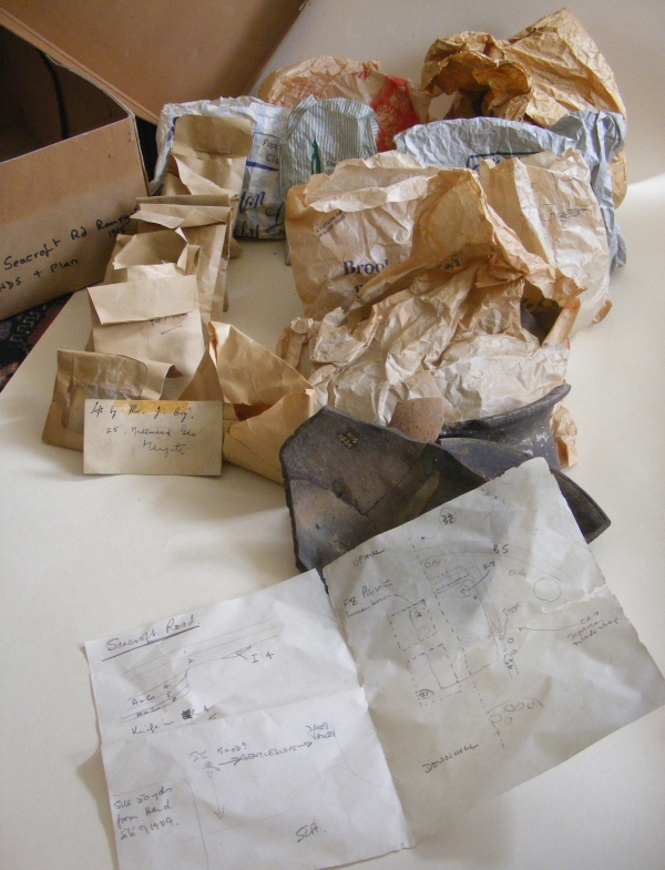
The Image for Day 293 of the VM_365 project is of the contents of the small cardboard archive box we started to look at in the post for Day 292. Although we have an idea from the label of the general area where the material may come from, a site at Dumpton Down between Broadstairs and Ramsgate, there is no record of what is actually in the box.

Our first task is to see what sort of material the archive contains, and what condition it is in. Then we need to know what sort of information it might be able to give us. In fact, even at first examination the box contains some very useful material. At least the box doesn’t contain bags of unwashed pottery or dried up leather.  The artefacts, which generally seem to be  pottery sherds of small to large size, seems to have been processed well.

Among the  containers stored in the box amount to eight paper bags from shops, which in themselves amount to something of a historic archive. There are also eight small brown paper envelopes, of a type people would have received cash wages in. Another similar wage packet envelope as a clear window in the front. There is one standard small brown envelope and a quantity of loose pottery sherds, some glued together to reconstruct part profiles. A small card in the box has the address of the excavator, Mr. Joe Coy,  from the  1960’s or 70’s written on it.

Best of all, there is a small paper sketch plan of an excavation, possibly where the artefacts came from. It’s not a perfect plan but it will help to evaluate what the finds in the bags can tell us. Each bag seems to have a feature code written on it, which may correspond with the plan and most of the sherds are marked with a site and feature code.

Although perhaps the containers leave something to be desired in archive stability, polythene mini-grip bags are probably preferable to a paper bag from a butcher’s shop in Margate, they have retained their contents reasonably well in the half century since the excavation was carried out.

In our next post for VM_365 Day 294 we will take a look at what is actually in some of the bags and what we might learn from the finds.

VM_365 Day 282 Old meets new at Pegwell

VM 282

Today’s image for Day 282 of the VM_365 project shows the segment of a Neolithic causewayed enclosure that was excavated in 2007 at Courtstairs, near Pegwell Bay. What is interesting in this picture is that you can see human activity on the site spanning a period of over 5500 years.

The earliest element is the linear cut of the Neolithic causewayed enclosure, formed by the excvavation of a continuous curving line of conjoined pits. The fills of the individual cuts containing pottery sherds shown on Day 172 including some from a round based vessel shown on Day 187; finely worked flint blades and bladlets shown on Day 171 and a flint sickle that was featured on Day 173, as well as animal bone, mainly representing large cattle species.  A cow skull that featured on Day 186 was found at the base of one of the pits forming the enclosure and was carbon dated to 3636-3625 cal. BC.

Jump forward over 5000 years and you can see the concrete footing for a building that most recently occupied the site, its foundations cutting the fills of the Neolithic enclosure.  Alongside the linear concrete foundation was a drainage trench containing a modern drain and an electricity cable. In the background you can see the blue plastic pipe supplying mains water to a nearby building.

Until the early 19th century the Isle of Thanet was sparsely populated and had little development on the rolling chalk hilltops overlooking the coast, which may have attracted the Neolithic settlers to the site. The explosion of seaside suburban development has hidden many of our most significant prehistoric sites under the foundations and gardens of Thanet’s coastal towns. On rare occasions archaeologists are able to uncover some of these sites for investigation.


VM_365 Day 270 Medieval purse frame

VM 270
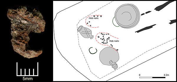
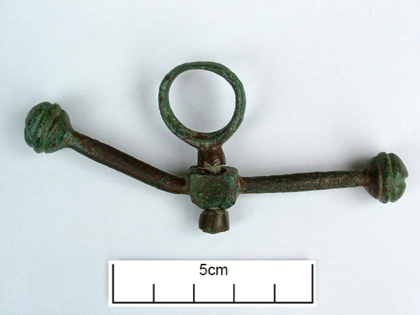
Today’s image for Day 270 of the VM_365 project shows a medieval copper alloy purse frame dating from the period 1474-1550 which spans the reigns of Edward IV, Edward V and Richard III. The purse frame was found in the excavation of a medieval well at Little Cliffsend Farm that was previously featured on VM_365 Day 251.

The metal frame would have supported a fabric or leather purse suspended from the bar, one of the arms of which is now bent. The purse and frame would then have been suspended from a belt or other strap by the central, swivelling, suspension loop.

We can only speculate as to whether this was just an item thrown away with other waste into the well, or whether it was an unfortunate loss by someone leaning over the edge to draw water. Either way it seems that the purse was empty when it ended up in the well.

VM_365 Day 266 The barrow reconstruction drawings get more complicated

VM 266

The image for Day 266 of the VM_365 project is the second in a series of images drawn by Dave Perkins, reconstructing the sequence of event associated with a funerary monument that was revealed in excavations at Lord of the Manor, Ramsgate.

In today’s image, the single ring ditch and mound that was shown in yesterday’s picture is being renewed, ready to receive another burial. The original ring ditch and its mound, now compressed and discoloured, have been sealed under fresh chalk which is being dug from a new ring ditch with a greater diameter than the earlier one. The circuit of the new ditch is  interrupted by a causeway, where a stretch of the circuit was not excavated. It is a process like this that created the concentric circuits of ditches that show up so well in the cropmark posted on VM_365 Day 264.

The location of the barrow is closely based on the landscape of the Lord of The Manor site, with the land falling away into a deep dry valley, which is shown covered with woodland. The sweep of the valley leads to the sea at Pegwell Bay in the upper right hand side of the picture. On the left side of the image a funeral procession is making its way up the side of the valley toward the newly refurbished barrow.

It is still possible in the present day to stand near the site of the barrow and see the same view over the bay which would have been presented to the prehistoric people of the area.  It was this experience of the landscape that Dave Perkins used to draw his reconstruction images.

Further analysis of the landscape has shown that there are only a few sites in Thanet’s landscape where such an uninterrupted view is possible and it becomes clear from considering the landscape that sites were carefully chosen to provide such a panoramic view. Excavations have shown that some were used over many thousands of years to locate settlements, gather for ceremonies and to create structures where the dead could be buried.

Once again we can reconstruct the facts that are presented by the archaeological features on the ground, but can never really confirm the reasoning behind the choice of location which is so well captured in the drawing. Was it to assert a power or domination over the landscape or to enhance the visibility of the monument from other sites? Motives may have changed over time passing from willful choice into tradition whose meanings were lost in the passage of time.

The true motives are lost without the record of contemporary voices, but we can explore possible meanings through attempts at reconstruction like the drawings in this series of posts. There are questions to ask about this reconstruction: was the natural environment so open and free of the influence of man as it is shown? Was it as simple a task to create a barrow as is suggested? The ring ditches of the many barrows that have now been excavated in Thanet have demonstrated that they are often perfectly circular with regular and symmetrical profiles throughout the circuit, despite the hard chalk rock that had to be cut to create them. It is immediately possible to suggest the picture could be made more accurate with the addition of some figures carrying out some quite complex surveying and architectural control over the cutting of the ditch as well as an indication of the greater amount of labour that went into cutting away the chalk in such quantity. Our ideas progress through such criticisms of the reconstruction, which perhaps leads in the future to new images that take new ideas on board. Sadly they will not have the benefit of Dave Perkins’ wisdom and experience to inform them.

VM_365 Day 265 Art inspired by the Lord of the Manor prehistoric archaeology

VM 265

The image for today’s post on Day 265 of the VM_365 project is an illustration by the Trust’s first Director David Perkins, inspired, as much of his work was,  by the landscape and prehistoric archaeology of Lord of the Manor Ramsgate.

The archaeological excavations that were carried out to explore the many features that were revealed by aerial photography in the area near Lord of the Manor were very significant to understanding the scale of prehistoric settlement in Thanet.

Using their experience of digging several of the major sites  revealed in the Landscape, both Dave Perkins and Len Jay used their artistic skills to record their activities and to interpret the sites they  were uncovering.

The coloured drawing  by Dave Perkins recreates a scene associated with the insertion of a new burial into the mound of one of the prehistoric round barrows located at the crest of the hill, an event that was attested in the archaeological record.

The stark white of the chalk that lies  at a shallow depth below the soil are visible in the cut of the ring ditch and the central mound where it was cast over a primary burial located at the centre. Baskets and shovels show that the ditch has been newly cleaned to refresh the surface of the chalk. The scene shows the mound as having been partly removed, so that another burial can be inserted within the circuit of the ditch. The later burial is perhaps that of a member of family who wishes to be close to a relative, or perhaps a clan member who wants to remind his followers of the source of his power. The burial may be of an unrelated individual who want to claim a connection with the glories of a bygone age. Grieving family members, along with warriors and perhaps elders of the clan are shown outside the ring ditch, while the person to be buried is carried across the ditch to the new grave.

Although the drawing reflects  the archaeological facts that were established from the sequence recovered from the ground, the truth of the scene’s representation of Bronze Age culture can never be known as there are no records to guide our interpretation with certainty.

VM_365 Day 264 Cropmarks record ancient Ramsgate landscape

VM 264
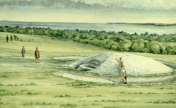
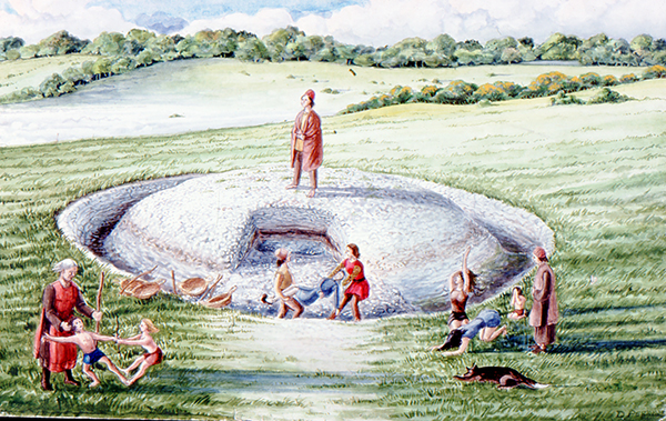
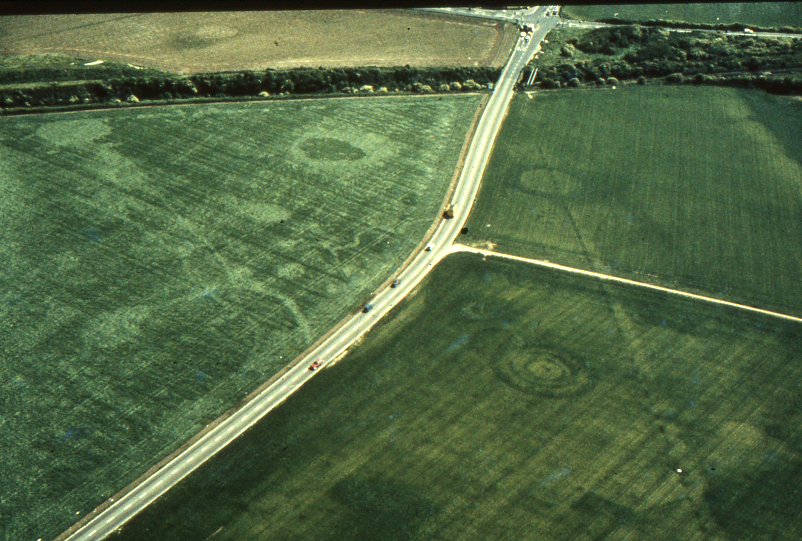
Today’s image for Day 264 of the VM_365 project shows an aerial photograph of one of the most impressive groups of crop mark groups in Thanet’s historic landscape. The picture was taken in the the late 1970’s, from an aeroplane flying over the downland ridge at Lord of the Manor, Ramsgate overlooking Pegwell Bay.

In the photograph, which is facing south east toward Ramsgate, a chalk ridge extends from the lower right corner of the picture toward the top left. The ridge is isolated by the dry valleys that flank it on the right and left hand sides, affording spectacular views over the coastline to the south .

The overflight to photograph the cropmarks took place before several major developments in the road network in the immediate area took place, preserving a record of the  landscape despite the considerable changes  that have happened in recent years. The linear markings and circular shapes that can be seen through the variations in the colour of the crops growing in the field, indicate the locations of buried archaeological features and sites, which have been investigated in many phases of archaeological investigations that were guided by the location of the crop marks since the photograph was taken. The effect of buried archaeological sites  which produced the variations in colour in the growing crop was explained in a drawing produced by Dave Perkins in our VM_365 post for Day 252.

At the junction between a road and a railway cutting that can be seen at the top right of the picture, one of the earliest published archaeological investigations was conducted by William Rolfe, Thomas Wright and Charles Roach Smith, when an Anglo-Saxon cemetery was disturbed by the railway cutting in 1846.  A drawing made of one of the graves was shown on VM_365 Day 225. The Saxon cemetery and the more ancient Bronze Age ring ditches that had occupied the ridge, continued to be investigated in several stages in the later 20th century.  Images of some of the excavations of the Anglo-Saxon cemetery that were carried out in the 1980’s were shown in the VM_365 posts for Day 216 and Day 217.

The three concentric ring ditches of a multi-phase monument, which was first constructed in the Neolithic period and was renewed in the Beaker and Bronze Age periods, can be seen in the bottom right part of the image. A view of the partial excavation of the three ring ditches in 1976 was shown in the image for Day_21.

Archaeological work in this landscape has continued to be carried out with the ditches of an Iron Age settlement being explored in 2012 and in a  training excavation carried out as recently at 2013.


VM_365 Day 257 Roman bottle from Ramsgate

VM 257

Today’s image for Day 257 of VM_365 shows a Roman bottle that was found in a grave excavated in Ramsgate in 2007.  The grave has featured in previous VM_365 posts, along with the finds that were present in the grave, the individual pottery vessels and evidence for the hob nailed shoes the young woman was buried with.

This bottle is classified as Pollard type 169 and has been manufactured in pinkish-brown Hoo St Werburgh fabric. It has a chipped rim, which may have been caused by the flint which was used as a stopper. The vessel dates between  c.AD.150-250/300.


VM_365 Day 256 Colour Coated Roman Beaker from Ramsgate Roman Grave


VM 256
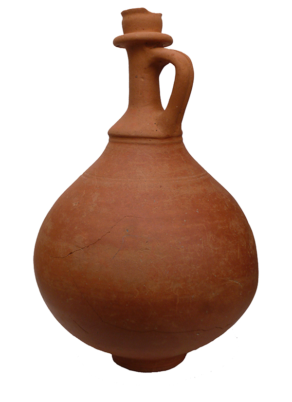
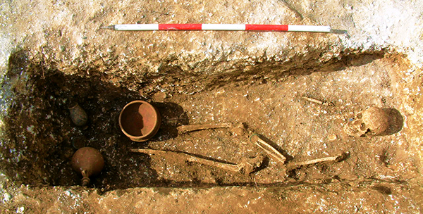
The image for Day 256 0f the VM_365 project is of a Roman Beaker found in a grave excavated in Ramsgate, which has featured in a series of previous VM_365 posts, along with the finds that were present in the grave and evidence for the hob nailed shoes the individual was buried with.

The beaker is in a colour coated ware, which means that the light coloured fabric of the pottery has been totally covered with a slip of dark glaze. The exterior of the pot was decorated further buy adding a white painted lattice pattern. The beaker was possibly manufactured in Gaul, in 3rd or 4th century AD.

Perhaps a story of greater human interest represented by this vessel are the impressions of the fingers of someone who grasped the body of the vessel before the clay had dried and left a lasting memorial of their otherwise unrecorded existence.

The survival of the intact vessels on the small archaeological site, despite the demolition of the buildings above and the use of a large toothed mechanical excavator bucket to grub out the foundations of the building that stood above it, is a matter of incredible luck.

VM_365 Day 255 Roman Hobnails in a grave from Ramsgate

VM 255

Today’s image for Day 255 of the VM_365 project follows on from yesterday’s journal post about the late 3rd to early 4th century burial at Ramsgate. It shows one of the best preserved of the 29 hobnails excavated from the grave along with a location plan of where they were found.

It is not clear  if all the hobnails survived and, as the grave had been heavily disturbed by plant roots, it was not possible to determine the exact pattern of hobnails. Two groups of hobnails were identified presumably representing two seperate shoes which may have been worn by the young adult female when she was buried.

Hobnails were used to prolong the life of footwear which was usually made entirely of leather and to give them a better grip on the floor surface.

VM_365 Day 254 late 3rd to Early 4th Century grave from Ramsgate

VM 254

Today’s image for Day 254 of the VM_365 project shows a late 3rd to early 4th century Roman grave, excavated in Ramsgate in 2007.

The grave was orientated north east to south west and had been heavily truncated in the past from later activity on the site. The grave cut measured only 0.3 metres deep when it was excavated.

The skeletal remains were of a young adult female, laid on her back with her legs extended and the left arm slightly flexed with the wrist resting on the pelvis. The bones of her right arm were very fragmentary and their exact position could not be determined. The general condition of the skeleton was poor as no hand, ribs, spine or foot bones survived and most ends of the long bones were missing.

The woman had been buried wearing a twisted copper alloy wire bracelet on her left wrist and she may also have been wearing shoes as twenty nine hobnails were recovered from the end of the grave in the approximate location of her feet.

Ten iron nails found around the edge of the grave suggest that a wooden board had been placed over her body. The body was accompanied by three pottery accessory vessels – a bowl, a bottle and a beaker placed at the end of the grave on top of the board, along with a second copper alloy bracelet  and a loop of wire which may have fastened a fabric pouch.

The bowl was located over the right lower leg, the loop of narrow copper alloy wire with two twists or knots which may have fastened a fabric pouch was found under the rim. The beaker had been placed on the north western side of the grave and the bottle, apparently sealed with a stopper made from a natural flint nodule, had been place on the south eastern side. The copper alloy bracelet lay between the bottle and beaker.

This burial is very significant as it complements the antiquarian records of similar discoveries in the immediate area which were published by Robert Hicks in the 19th century.