Category Archives: Broadstairs

VM_365 Day 362 Guest VM curator on Thanet’s Roman samian pottery

VM 362
For Day 362 of the VM_365 project we have a roundup of the images that accompanied posts made by one of VM_365’s guest curators, Dr. Steve Willis of the University of Kent, an expert of the distinctive Roman samian pottery which has been found on so many of the archaeological sites of Roman Thanet.

Samian vessels featured in several  VM_365 posts. Day 297 featured samian sherds from a site at Dumpton near Broadstairs and Day 102 featured a small samian cup from the remains of a kitchen found at a Roman site in Broadstairs. Day 183 featured a samian sherd  with evidence for a repair from the same site and Day 54 featured a sherd of samian with a name scratched on the surface.

With an expert’s eye and detailed knowledge the assemblages of finds collected by archaeologists can reveal hidden details, even from the smallest elements and Steve’s knowledge of Roman pottery has helped to provide detailed information for a number of VM_365 posts.

One of the most extensively excavated of the major buildings of the Roman period in Thanet is the large Villa at Minster, which appeared in several VM_365 posts. In VM_365 posts  two samian beakers of the rare Dechelette 64 form,  found in the Minster villa excavation, were examined by Dr. Willis. Day 175 of the VM_365 project featured a beaker manufactured in the workshop of Libertus, who was producing pottery at Lezoux in the early 2nd century. The beaker on Day 179 was slightly later, and is decorated with a chase scene. The post also featured an interesting biography of the French archaeologist Joseph Déchelette who first catalogued the samian vessels manufactured in Gaul.

On Day 86 of VM_365 the post visited a box full of samian and other Roman pottery, which belongs to an archive of finds and records which has been given to the Trust to store. Steve was able to examine the pottery contained in the box and to give more detail on the forms and dating of the pottery in a later post on Day 345. in a strange co-incidence, the post written by Steve for Day 346 pointed out that one of the vessels that formed the contents of the wooden storage crate was manufactured in the same place, near Colchester in Essex, nearly two thousand years later. The parallel was drawn that the transport of goods a very useful form of evidence for archaeologists!

The images that went to make up this round up picture were produced by Lloyd Bosworth, archaeological technician at the University of Kent.

VM_365 Day 360 Reading Street, Broadstairs

VM 360Today’s image for Day 360 of the VM_365 project shows a series of images of another of our Hidden Hamlets in the Our Thanet series this time from Reading Street, Broadstairs.

The hamlet of Reading Street is located on the north side of Broadstairs. The earliest buildings, most of which are located along the main road through the hamlet also known as Reading Street, date from the early 18th century although the hamlet may have had earlier origins; nearby on Elmwood Avenue, east of the main focus of the settlement, is Elmwood Farmhouse, part of which is a 16th century timber framed building.

Roughly knapped flint, with brick dressings is the predominant material used in the construction of the earliest buildings in Reading Street with brick becoming the main material used in the 19th and 20th century as the hamlet expanded.

White Swan cottage (top left) is an early 18th century house set end on to the road and is built of flint with curved Flemish gable ends edged in brick. Further along Reading Street is a second early 18th century Flemish gabled house, Rozine Cottage (top right). At the eastern end of Reading Street there is also a row of cottages built in a similar style with curved gabled ends which were constructed in 1901.

At the western end of Reading Street is a group of cottages dating to the early 18th century (bottom left). One of these cottages, Joss Cottage, is where the legendary local smuggler Joss Snelling is reported to have lived. The end wall of Corner Cottage which faces on to Astor Road is particularly interesting as it features a number of blocked window openings. At the western end of the group is a particularly striking cottage with a three storey, early to mid-19th century component built of flint with stock brick dressings (bottom right).

Trinity Square is a little side road leading from Reading Street which contains an interesting mix of small 19th and 20th century houses and cottages in both flint and brick. Trinity Cottage on the corner of Reading Street, (top middle) is a pretty example of a 19th century cottage faced in flint with stock brick dressings.

Reading Street has plenty of other interesting buildings that have not been featured here including Elmwood, which was the home of Cecil Harmsworth, the famous newspaper proprietor who later became Lord Northcliffe and was Propaganda Minister during the first World War.

VM_365 Day 357 Dumpton Gap, Broadstairs historic landscape

VM 357

Today’s image for Day 357 is another one in the Our Thanet thread for VM_365. The overview of Dumpton Gap is taken from near the entrance to Seacroft Road, which is on the extreme left of the image. The view faces north across the bay where the deep valley meets the sea at the high chalk cliffs on the right side of the image.

Only as far back as the late 19th century this landscape was open downland, but at the beginning of the 20th century, the benevolent seaside landscape attracted several large convalescent homes, which were served by new roads that were laid out on the cliff top esplanade. A view similar to the one in today’s image was published in a 1907 sale catalogue for plots in the area, posted on Day 41 of the VM_365 project.

In the process of creating the framework of the dense suburb that now covers the valley, many significant archaeological discoveries were made. The earliest of these were recorded by Howard Hurd, one of Thanet’s heritage pioneers,  who as Borough Surveyor for Broadstairs and St. Peters laid out much of the road network which can be seen in the catalogue photograph.

On the slopes of the far side of the valley, on the horizon just left of the centre of the image is Valletta House, now Bradstow School, where Howard Hurd excavated and published a Bronze Age round Barrow and Anglo-Saxon cemetery. The site went on to be explored in several excavations as the gardens surrounding the house were developed over the next century revealing more Neolithic, Bronze Age and Iron Age features, as well as a further burial from the Anglo-Saxon cemetery.

On the far left side of the image, an extensive Iron Age settlement located on the southern side of the valley which later became the site of a Roman building,  was discovered by Howard Hurd in the early 20th century. A bone weaving comb from the site was published on Day 110 of the VM_365 project.

The site was explored further  in several excavations from the 1960’s to the 21st century when the development of suburban roads and closes with characteristic bungalows and semi-detached houses, were explored by Joe Coy, another important heritage pioneer. Pottery of Iron Age and Roman date from these excavations featured in several previous VM_365 posts.

The landscape shown in today’s post is perhaps one of the richest sources of archaeological information in Kent, but is little known in the wider archaeological community because of the limited circulation of the publications of the excavations and the lack of any recent attempt to bring all the sites together and reconsider their significance. Perhaps this overview for the VM_365 project will serve as a start in that process.

VM_365 Day 355 Farewell to all that

VM 355

Today’s post for Day 355 of the VM_365 project features a series of images behind the scenes at our Friendships and Fallouts, Waterloo to World War One TimeTunnel, which has featured in the last four days of VM_365.

Day 351 took you through the first stage of the Tunnel, exploring Britain at the time of Waterloo, Day 352 took us to the Victorian period and the Crimean War. The industrial era and the age of Inventions in the 19th century featured on Day 353 and we entered World War One on Day 354.

Today’s picture shows how we built the flats that featured in the Time Tunnel and some of the scenes along the way, as well as some of the lighter moments of setting up and running the Time Tunnel experience.

Once again we had great fun at Bradstow School and we hope that we gave an interesting and educational experience to our travellers through time.

It all over now, and it isn’t even Christmas

VM_365 Day 350 Virtual Museum TimeTunnel for School Event

VM 350

Today’s image for Day 349 of the VM_365 project was taken as the Trust set up a Virtual Museum TimeTunnel, ready for four days of workshops for schools to be hosted at Bradstow School in Broadstairs from the 15th to the 18th of June 2015.

The Heritage Lottery funded event ‘Friendships and Fallouts, from Waterloo to World War One’ will see as many as 500 children pass through the workshops and activities in the grounds of the school. The event commemorates both the bicentenery of the battle of Waterloo and the continued marking of the hundredth anniversary of the First World War.

The TimeTunnel will take children on a journey through the changes that took place in British life in the hundred years from the defeat of Napoleon to the outbreak of a conflict that reached every part of the world.  The TimeTunnel visits  a series of scenes that explore the changes from industrialisation to the great inventions of the early 20th century which created the means to make global conflict possible.  As the journey through the tunnel takes place, the friendships between nations, families, working people and soldiers are investigated and the fallouts that provoked conflict between people and nations are revealed. The journey through the TimeTunnel ends in the battlefields of the Western Front with the fate of all the travellers left undecided.

Journal articles over the next four days will reveal the secrets of the VM TimeTunnel and follow the progress of the event.

VM_365 Day 337 The Follies of Kingsgate Bay

VM 337
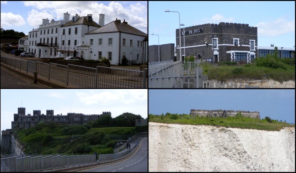
Today’s image, for Day 337 of the VM_365 project and another in the Our Thanet series, shows four views of some of the ‘follies’ at Kingsgate Bay, Broadstairs that were constructed by Henry Fox, Lord Holland, in the 18th century.

Henry Fox served as a Whig politician between 1735-1765 and was the father of the Honourable Charles James Fox, another famous Whig Politician. As Lord Holland he held various posts including Paymaster-General of the Forces, a post that he used  to increase his personal fortune from the public purse and from which he was finally forced to resign in 1765.

Lord Holland came to Kingsgate in 1761 to escape his political life and public hatred. Kingsgate Bay had formerly been called called Bartholomew’s gate but gained its present name from the landing of Charles II at the bay in 1683.  A medieval arch and portcullis once defended the ancient gap through the cliffs, but it was destroyed by gales in 1819.

Lord Holland built a house and surrounded it with follies, structures built in the style of ruins from antiquity, which were then fashionable. Holland House (shown in the top left of the picture) was constructed in classical style around 1760. The house  fell into ruins around the end of the 18th century and most of the present façade dates to the mid 19th century when it was rebuilt. The original central portico of the  Holland House was removed to the Sea Bathing Hospital at Margate.

The follies at Kingsgate included a Bede-House, a Castle, a Convent and a temple, although most of the Follies concealed practical purposes. The Bede-House (in the top right of the picture) was constructed on the cliff on the western side of Kingsgate Bay in the late 18th century as a house of entertainment for visitors who flocked to see all of Lord Holland’s follies. By the early 19th century the building had become known as the Noble Captain Digby, after a nephew  of Lord Holland who commanded HMS African at Trafalgar. Much of the original structure was destroyed when it fell into the sea during a strong gale, but surviving parts of the earlier structure are incorporated into the mainly early 19th century construction of the present Captain Digby Inn.

The temple of Neptune on White Ness (in the bottom right of the picture) was built in the late 18th century as a miniature copy of the Tudor blockhouses at Camber and Deal which Henry VIII used to defend the south east coast. In the Second World War the temple tower served as a post for the Royal Observer Corps. In the same year that the Temple of Neptune was built, a respected local Vicar recorded his opinion that a tower named the Arx Ruohim, or tower of Thanet, had been built on the same site by King Vortigern in A.D. 448. The story was taken as fact and even gained places on reputable maps and in local guidebooks and as a result people came to to look at the ‘Saxon’ Tower.

Kingsgate Castle (bottom left of the image) was a copy of a Welsh Castle and was  constructed on the cliff top on the eastern side of Kingsgate Bay. This building was used as stables by Lord Holland but eventually fell into disrepair. A large round tower is all that remains of the original building. The structure was added to over the years and later rebuilt in 1913 by Lord Avebury, incorporating most of the original fabric. The building has been converted into residential flats in recent years .

Another of the follies was known as the Convent (not pictured). Originally built as five cells arranged around a central cloister it was intended to be used as a convent for Anglican Nuns, but they  never occupied the building. Instead the Convent was used as accommodation for the poor and industrious members of Lord Holland’s estate and also used as overflow accommodation for guests at Holland House. By 1831 the convent was rebuilt and renamed Port Regis. The remains of the medieval entrance to Bartholemew’s gate were rebuilt in the grounds.

Another commonly held ‘historical fact’, probably originating in similar circumstances to the Arx Ruohim myth, is still preserved in a local place name ‘Hackemdown’,  which is even recorded on Ordnance Survey maps. The name derives from an ‘historical event’, which was actually invented by Lord Holland. A barrow mound in the grounds of the convent was opened by Lord Holland and enough human remains were found for Lord Holland to suggest they were buried after a battle between Saxons and Danes. Lord Holland commemorated his invention by building a tower on the site of the barrow mound, complete with an inscription to the dead. The tower became known as Hackemdown Tower and other barrow mounds nearby became known as Hackemdown Banks. The cliff which Holland suggested the remainder of the dead from the battle were pushed became known as Hackemdown Point.

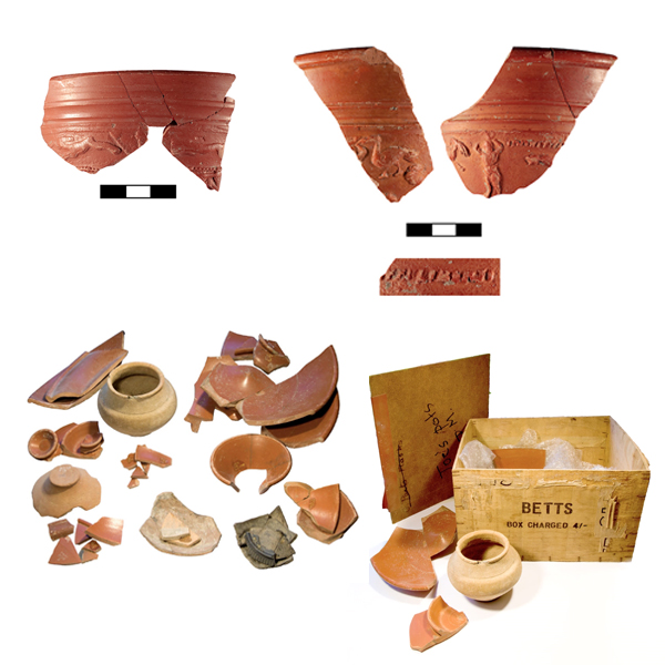
While Lord Holland’s battle was pure fiction, it was based on real archaeological finds. Holland was prompted to open his barrow mound after a farmer at Reading Street Farm had opened a larger mound nearby in 1743, in the presence of many hundreds of people. Records suggest that deep in the solid chalk under the mound several stone capped graves were found. Human skeletons bent almost double and several urns of coarse earthenware filled with ashes and charcoal were reported to have been found. Both the mounds opened by the Reading Street farmer and Lord Holland are more likely to date to the late Neolithic or Early Bronze Age.
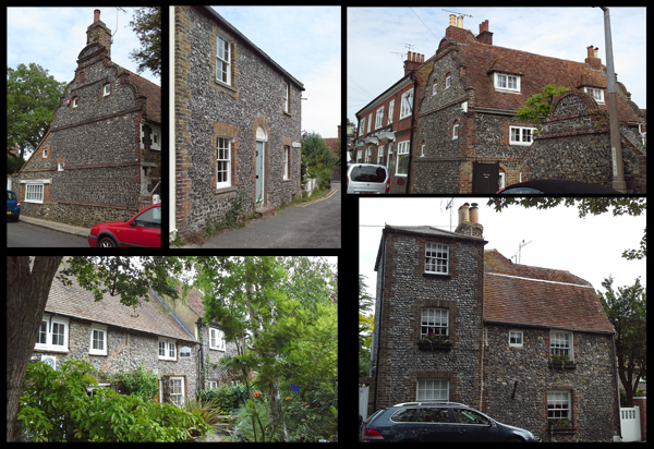
VM_365 Day 336 The landscape from Dumpton Gap to Viking Bay

VM 336
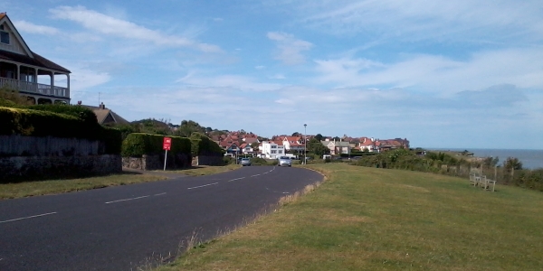
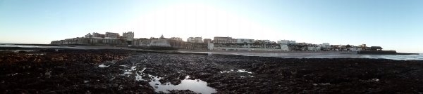
Today’s image is another in the Our Thanet series of posts. This time it is a view of the coastline from Dumpton on the left side to Viking Bay at Broadstairs on the right.

This part of Thanet’s coast is also subject to heavy erosion, which has formed a distinctive wave cut platform which can be seen in the foreground and the high chalk cliffs that can be seen in the centre of the picture.

Like the other coastal areas shown in our two previous days posts, this landscape would not have been recognisable to the prehistoric inhabitants of Thanet, who may have lived and died on rolling downland slopes that have been cut away by the sea. Their coastlines were much nearer to the vantage point on the edge of the platform where the picture was taken, but were always advancing toward the high central chalk ridge of the isle.

If they were somehow able to return, even the later Iron Age people and the Roman settlers of the area would have trouble placing themselves, their settlements and their buildings which are known to exist at Dumpton on the far left and on the promontory next to Fort House on the extreme right.

Much of the archaeological evidence of past occupation in the landscape between has been lost to the cliff falls that occur regularly following storms at sea and we will now never be able to piece together the whole story of early settlement along the coastline that is shown in today’s image, which makes the knowledge we have gained from previous excavations, many of which were carried out by pioneering archaeologists like Howard Hurd and Dave Perkins and have featured in earlier posts, so much more significant.

VM 365 Day 333 Hidden Hamlet of Upton, Broadstairs

VM 333

Today’s image for Day 333 of the VM_365 project shows a series of views of surviving agricultural buildings in the now hidden hamlet of Upton which is located on the eastern side of Broadstairs.

The main focus of the former hamlet is located around the junction of Fair Street and Vale Road. This picturesque corner of Broadstairs contains a number of buildings and features reflecting its rural past that are easily visible from the road.

The oldest surviving building is Little Upton, shown in the top left of the image. This Dutch gabled house was constructed in the late 17th century in two sections with different roof levels and is located on the northern side of Vale Road.

On the opposite side of Vale Road you can see the remnants of Upton Farm which incorporates an Oast House, (bottom left)  probably originally constructed in the 18th century as a timber framed single storey barn. The pyramidal slate cap on the left side is a mid 19th century construction. If you look at the brick gable end that faces on to the footpath you can see where the roof has been raised probably in the 19th century.

Other buildings hinting at the area’s rural past can be seen along Vale Road (top right) where long, narrow flint built buildings are located side on to the street aligned along the edge of  the former farmyard. Near the junction of Fair Street is a long brick and flint wall forming the boundary to a cottage. This wall has many phases in its construction and once formed part of an agricultural building or barn that has since been demolished.

There are lots of other elements visible in the street scape around Upton that hint at its rural past which can be easily identified if we take the trouble to really look.


VM_365 Day 325 The parish church of St Peter the Apostle, St Peters, Broadstairs

VM 325

Today’s image for Day 325 of the VM_365 project shows the parish church of St Peter the Apostle which is located in the vilage of St Peter’s, Broadstairs. Like the parish church of St John the Baptist, Margate which featured on Day 324 of the VM_365 project, this was originally a chapel to the mother church at Minster before becoming a parish church in its own right in the 13th century.

This church was constructed in the 12th century and was originally much smaller consisting of a chancel, nave and a south aisle with at least two bays. The original Norman arcade of mid 12th century date still survives. The church was extended with the addition of a north and south aisle in the late 12th century. The existing north chancel arcade may be of early 13th century date.

In the 14th century the Norman aisles were widened and the north west tower with its crenellations and gargoyles was added in the early 15th century.

Interestingly the church tower was used as a signalling station in Napoleonic times due to its then highly visible location and it still has the right to fly the White Ensign.

Like our other parish churches on Thanet, this church was heavily restored in the mid 19th century.

References/Further Reading

Berg, M. and Jones, H.  2009. Norman Churches in the Canterbury Diocese. The History Press.

Historic England 2015. The National Heritage List for Britain: The Parish Church of St Peter the Apostle. List entry no. 1273791. http://list.historicengland.org.uk/resultsingle.aspx?uid=1273791&searchtype=mapsearch

St Peter in Thanet. 2015. A Brief History of the Church. http://www.stpeterinthanet.org.uk/aboutus.htm

VM_365 Day 305 Filling in the blanks……

VM 305
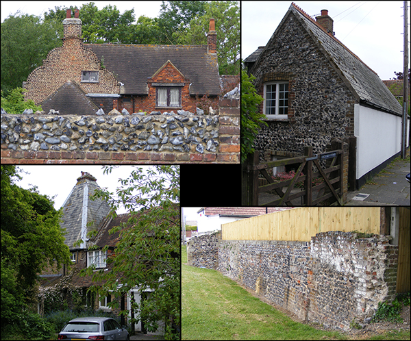
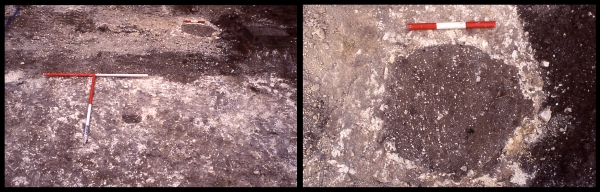
Today’s image shows two views of a very small excavation carried out during the construction of a garage at North Foreland Road, Broadstairs in 2004.

The North Foreland landscape is particularly rich in archaeological remains. Cropmarks identified by aerial photography show an ancient trackway along the edge of the hillside. A large open area excavation carried out in recent years on the previously undeveloped playing fields of the former St Stephen’s College confirmed that the area had been occupied at least since the Early Bronze with the construction of burial mounds and during the Iron Age when a settlement was established which included a Middle Iron Age enclosure and significant numbers of postholes and large storage pits.

The area to the east of the site was developed for housing from the late 19th century onwards and although occasional archaeological discoveries were reported these were generally made before a time when the significance of the area was understood and archaeological features were often not recorded in detail or at all. So how do we fill in the blanks in an area that has already been developed?

As a local archaeological organisation, we are often involved in very small scale construction projects such as, for example, a small garage for a house along North Foreland Road, not far from the St Stephen’s site shown in the images above. The excavations only covered an area of approximatley 6 metres by 5 metres and the ground had already been disturbed by modern drainage which is visible as a linear stripe of dark soil visible above the T shaped scale in the picture on the right. However, eight pits and postholes containing Iron Age pottery still survived suggesting that the Iron Age settlement excavated at the St Stephen College site was much more extensive. An example of one of the pits is shown in the picture on the right.

Through the keyhole of small investigations such as these we can fill in the missing detail and gradually build up a bigger picture of the landscape.