Category Archives: Landscape

VM_365 Day 360 Reading Street, Broadstairs

VM 360
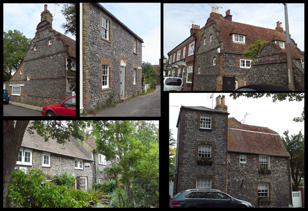
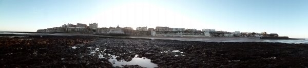
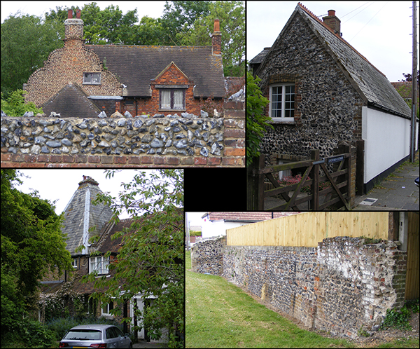
Today’s image for Day 360 of the VM_365 project shows a series of images of another of our Hidden Hamlets in the Our Thanet series this time from Reading Street, Broadstairs.

The hamlet of Reading Street is located on the north side of Broadstairs. The earliest buildings, most of which are located along the main road through the hamlet also known as Reading Street, date from the early 18th century although the hamlet may have had earlier origins; nearby on Elmwood Avenue, east of the main focus of the settlement, is Elmwood Farmhouse, part of which is a 16th century timber framed building.

Roughly knapped flint, with brick dressings is the predominant material used in the construction of the earliest buildings in Reading Street with brick becoming the main material used in the 19th and 20th century as the hamlet expanded.

White Swan cottage (top left) is an early 18th century house set end on to the road and is built of flint with curved Flemish gable ends edged in brick. Further along Reading Street is a second early 18th century Flemish gabled house, Rozine Cottage (top right). At the eastern end of Reading Street there is also a row of cottages built in a similar style with curved gabled ends which were constructed in 1901.

At the western end of Reading Street is a group of cottages dating to the early 18th century (bottom left). One of these cottages, Joss Cottage, is where the legendary local smuggler Joss Snelling is reported to have lived. The end wall of Corner Cottage which faces on to Astor Road is particularly interesting as it features a number of blocked window openings. At the western end of the group is a particularly striking cottage with a three storey, early to mid-19th century component built of flint with stock brick dressings (bottom right).

Trinity Square is a little side road leading from Reading Street which contains an interesting mix of small 19th and 20th century houses and cottages in both flint and brick. Trinity Cottage on the corner of Reading Street, (top middle) is a pretty example of a 19th century cottage faced in flint with stock brick dressings.

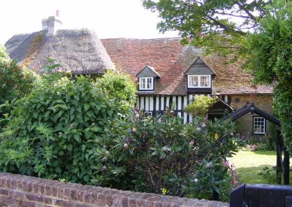
Reading Street has plenty of other interesting buildings that have not been featured here including Elmwood, which was the home of Cecil Harmsworth, the famous newspaper proprietor who later became Lord Northcliffe and was Propaganda Minister during the first World War.

VM_365 Day 357 Dumpton Gap, Broadstairs historic landscape

VM 357

Today’s image for Day 357 is another one in the Our Thanet thread for VM_365. The overview of Dumpton Gap is taken from near the entrance to Seacroft Road, which is on the extreme left of the image. The view faces north across the bay where the deep valley meets the sea at the high chalk cliffs on the right side of the image.

Only as far back as the late 19th century this landscape was open downland, but at the beginning of the 20th century, the benevolent seaside landscape attracted several large convalescent homes, which were served by new roads that were laid out on the cliff top esplanade. A view similar to the one in today’s image was published in a 1907 sale catalogue for plots in the area, posted on Day 41 of the VM_365 project.

In the process of creating the framework of the dense suburb that now covers the valley, many significant archaeological discoveries were made. The earliest of these were recorded by Howard Hurd, one of Thanet’s heritage pioneers,  who as Borough Surveyor for Broadstairs and St. Peters laid out much of the road network which can be seen in the catalogue photograph.

On the slopes of the far side of the valley, on the horizon just left of the centre of the image is Valletta House, now Bradstow School, where Howard Hurd excavated and published a Bronze Age round Barrow and Anglo-Saxon cemetery. The site went on to be explored in several excavations as the gardens surrounding the house were developed over the next century revealing more Neolithic, Bronze Age and Iron Age features, as well as a further burial from the Anglo-Saxon cemetery.

On the far left side of the image, an extensive Iron Age settlement located on the southern side of the valley which later became the site of a Roman building,  was discovered by Howard Hurd in the early 20th century. A bone weaving comb from the site was published on Day 110 of the VM_365 project.

The site was explored further  in several excavations from the 1960’s to the 21st century when the development of suburban roads and closes with characteristic bungalows and semi-detached houses, were explored by Joe Coy, another important heritage pioneer. Pottery of Iron Age and Roman date from these excavations featured in several previous VM_365 posts.

The landscape shown in today’s post is perhaps one of the richest sources of archaeological information in Kent, but is little known in the wider archaeological community because of the limited circulation of the publications of the excavations and the lack of any recent attempt to bring all the sites together and reconsider their significance. Perhaps this overview for the VM_365 project will serve as a start in that process.

VM_365 Day 356 Historic Margate ancient and modern

VM 356
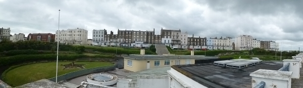
The image for day 356, which continues our intermittent Our Thanet series is a panoramic view of part of Margate, taken across the roof of the Margate Winter Gardens and facing the terrace of houses standing on Fort Hill. The roof top of the Turner Centre, overlooking the historic Margate Pier can be seen on the far right of the image.

Although much celebrated for its recent arty renaissance in association with the Turner Contemporary Galery and the the Dreamland theme park which opened its doors again this weekend, this area is one of Margate and Thanet’s richest areas for the archaeology of the Iron Age and Roman period.

An Iron Age burial lying in a circular pit cut into the chalk geology was found during the demolition of parts of the former Cobbs Brewery complex and the construction of a  Police Station which stands behind the last buildings at the right hand end of the terrace.

The remains of post built structures and pits also dating to the Iron Age indicated that a settlement had been present and a fine La Tene style decorated vessel found in a large pit nearby demonstrated something of the high status of the settlement.

Behind the houses at the centre of the image, in the area of Trinity Square redevelopment has revealed a dense cluster of Iron Age and Roman features cut into the chalk, these include several storage pits and at least three more pit burials. Roman cremations contained in pottery vessels were found in construction work in the 19th century, in the area behind the right hand end of the terrace of buildings shown in the picture.

The terrace of houses in today’s image follows the crest of one side of the deep valley that carries the Dane Stream to the Bay at Margate. On the downslope beyond the terrace are the subterranean passages of the Margate Caves and the Shell Grotto.

Until it was  sealed in a culvert in the Early 19th century the Dane Stream ran along the base of the valley parallel with the terrace in the image. The water supply for the Reeves and Co. Soda Water plant was drawn from this stream. Nearby, at the junction with Trinity Square and King Street at the bottom the valley is the restored 15th century house, formerly known as the Old House but now called the Tudor House. Adjacent to the house are the remains of a 17th century Malt House, which was  associated with Cobbs Brewery which extended over a large part of the valley slope at Fort Hill.

Margate continues to occupy a place in the nations heart as a quintessential seaside town. The image of the knife we posted on Day 95  shows that even the town’s newer attractions like  Dreamland, restored and re-opened as an attraction to a new generation of visitors produced its own historic artefacts to be  discovered by contemporary archaeologists.

Such a significant gathering place generates its own archaeological footprint and the ancient discoveries from the same area show that the landscape around Margate has been a place of gathering for over two millennia.

VM_365 Day 341 Unique vantage points and prehistoric sites

VM_341

The image for Day 341 is another in the series of Our Thanet posts, showing locations that play an important part in the exploration and appreciation of Thanet’s heritage.

The image shows a view taken facing south and south west from a downland hill top at Lord of the Manor, Ramsgate when part of the ring ditch associated with a Bronze Age round barrow was partly exposed in a training excavation in 2013.

Although it is partly obscured by trees and buildings that have grown up since a railway cutting was pushed through the chalk hillside in 1847, it is still possible to see the vista across the low lying bay that could be seen from the vantage point of the raised central platform enclosed by the ring ditch. From the centre of the mound the horizon falls away in a wide sweep from the north east to the south, giving a view across Pegwell Bay.

It can be no coincidence that a location commanding such an impressive view was chosen for the location of  such a major monument in the Bronze Age. Everywhere on Thanet where such unique points which command similar impressive views over the landscape can be found, there are also concentrations of prehistoric monuments, some unusually large in size or very complex such as the Lord of the Manor 1 multi phase monument which featured all the way back on Day 21 of the VM_365 project. Artistic reconstructions of the development of the landscape over time featured in an earlier series of VM_365 posts starting on Day 265.

This unique landscape is increasingly under pressure from development and it may soon not be possible to see what the prehistoric inhabitants of the Isle could see from the vantage points of the downland hilltops.

VM_365 Day 339 Downland landscape of Birchington

VM_339

The image for today, Day 339 of the VM_365 project, is a north west facing view of the historic downland landscape of Birchington. The view of the horizon beyond the cornfields stretches from the complex of Glasshouses at Thanet Earth on the left side to the tree enclosed Quex Park on the right.

All across this landscape in the ripening corn, the secrets of the archaeology below the ground are revealed in a mass of cropmarks. Some of the earliest images of archaeological sites revealed by cropmarks were aerial views of this very landscape published by OGS Crawford, known as the father of aerial archaeology, in the Journal Antiquity in 1934.

Excavations in advance of the construction of the Thanet earth glasshouses gave an opportunity to investigate a set of the largely unexplored crop marks in the landscape. Archaeological features from the Neolithic, Bronze Age, Roman, Anglo-Saxon and even modern periods were revealed as each greenhouse was built.

The Iron Age settlement of the landscape stretches far across the rolling hilltops and one of the most remarkable discoveries of the era was of a large hoard of Iron Age potin coins discovered when trees were planted to surround the newly enclosed Quex Park in the 1853. The remaining unexplored landscape almost certainly holds archaeological evidence of the same range of dates in the wide sweep of linear features and circular enclosures that can be seen in aerial views.

Standing archaeology visible in today’s picture includes the spire of the Parish Church of All Saints at Birchington near the middle of the picture and on the far right the historic Gun Tower within the grounds of Quex Park. Beyond the horizon in the image is the coast at Minnis bay, whose remarkable archaeological landscape was itself explored on Day 334 of the VM_365 project.

VM_365 Day 336 The landscape from Dumpton Gap to Viking Bay

VM 336
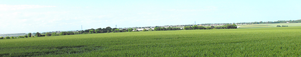
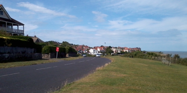
Today’s image is another in the Our Thanet series of posts. This time it is a view of the coastline from Dumpton on the left side to Viking Bay at Broadstairs on the right.

This part of Thanet’s coast is also subject to heavy erosion, which has formed a distinctive wave cut platform which can be seen in the foreground and the high chalk cliffs that can be seen in the centre of the picture.

Like the other coastal areas shown in our two previous days posts, this landscape would not have been recognisable to the prehistoric inhabitants of Thanet, who may have lived and died on rolling downland slopes that have been cut away by the sea. Their coastlines were much nearer to the vantage point on the edge of the platform where the picture was taken, but were always advancing toward the high central chalk ridge of the isle.

If they were somehow able to return, even the later Iron Age people and the Roman settlers of the area would have trouble placing themselves, their settlements and their buildings which are known to exist at Dumpton on the far left and on the promontory next to Fort House on the extreme right.

Much of the archaeological evidence of past occupation in the landscape between has been lost to the cliff falls that occur regularly following storms at sea and we will now never be able to piece together the whole story of early settlement along the coastline that is shown in today’s image, which makes the knowledge we have gained from previous excavations, many of which were carried out by pioneering archaeologists like Howard Hurd and Dave Perkins and have featured in earlier posts, so much more significant.

VM_365 Day 335 The landscape of Pegwell Bay

VM 335
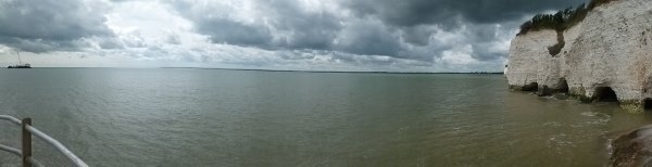
Our image today for Day 335 of the VM_365 project is another for the Our Thanet series. This picture shows Pegwell Bay, viewed from the southern end of the Ramsgate harbour esplanade. The thin band of land on the horizon stretches from Deal pier at the western end, past Richborough and the mouth of the River Stour to the cliffs on the north east edge of the bay with their sea caves.

Once again the early prehistoric inhabitants of the area would not have recognised the bay as it is today. Evidence of their settlement has been found on the fringes of the present coast where it continues to be eroded by the force of the waves. On the land above the cliffs to the right of the image, two neolithic causewayed enclosures have been discovered and there are many sites of Bronze and Iron Age date in the landscape.

Rising sea levels created the bay and expanded the Stour, dividing Thanet from the mainland. The Iron Age people of Thanet first saw Roman traders and invaders arrive off this Bay and the forts and town at Richborough were dominant sites in the Roman period. Later the early settlers of the Anglo-Saxon period also sailed into this bay at Ebbsfleet and in 597 St Augustine’s Christian mission landed near Cliffsend, near the right side of the image.

The Stour’s present mouth was created to serve a port and supply bases created to serve the western front in World War 1 and in World War 2 the D-Day mulberry harbours set out from the Bay.

This view over Pegwell Bay encompasses thousands of years of significant events in both Thanet and Britain’s history.

VM 365 Day 334 The landscape of Minnis Bay

VM 334

Today’s image for Day 334 of the VM_365 project shows a view of Minnis Bay, taken from the east, facing west toward Reculver. This view begins another short VM_365 series showing you our Thanet; the historic isle that we as archaeologists see around us.

Before the Bronze Age this landscape would have been significantly different. Sea levels were significantly lower than they are in the present day and much of the coastal area visible here would have been dry land.  A freshwater creek extended along the approximate route of Minnis Road, just out of the picture to the right. The flat greyish green area of the beach visible in the foreground are the remnant of chalk cliffs that once formed the edge of the valley the creek flowed through, which has been eroded to a flat platform by the sea pushing into the creek mouth in the later prehistoric period.

Many prehistoric finds including Palaeolithic and Neolithic worked flint have been found off this foreshore, the tools used by the people who once lived on the land that has been lost to the sea.  The remains of a Bronze Age settlement was discovered on the wave cut platform around the mouth of the creek in 1938. A Bronze Age hoard discovered in one of the pits has previously featured on Day 202 of the VM_365 project.

Beyond the wooden groynes that can be seen in the middle ground of the image is the former northern mouth of the Wantsum Channel, which became more significant as the sea advanced from the Bronze Age onward and separated what would become known as  the  Isle of Thanet from the mainland of Kent.

The sea continued to eat away at the land that was occupied by communities in later periods.  The bases of Late Iron Age and Roman pits and other features, possibly wells, have also been identified as truncated pits on the wavecut platform on the foreshore. Artefacts retrieved from these pits included a Roman millstone,  a two handled wine jar, and a colour coated dish.

Eroding pits and archaeological features of Late Iron Age and Roman date have been identified in the eroding cliff edges at Minnis Bay. On the horizon on the far right of the image is the site of a Roman fortress built on land at Reculver,  overlooking the mouth of the Wantsum Channel and the west coast of the Isle of Thanet.  The Fort and the settlement associated with it is beginning to be claimed by the sea. Coastal erosion has exposed the bases of Roman wells which are sometimes visible at low tide on the wave cut shelf at Reculver.

Reculver was also the site of one of the earliest and most important  Anglo Saxon monasteries. The former monastery and the church that now stands at Reculver were built on the site of the Roman Fort and elements of all these structures have been revealed in a long series of archaeological excavations.

The vantage point of the cliff top at Minnis Bay provides a view of thousands years of Thanet’s history which the archaeologist’s eye can distinguish from the natural landscape.

VM 365 Day 333 Hidden Hamlet of Upton, Broadstairs

VM 333

Today’s image for Day 333 of the VM_365 project shows a series of views of surviving agricultural buildings in the now hidden hamlet of Upton which is located on the eastern side of Broadstairs.

The main focus of the former hamlet is located around the junction of Fair Street and Vale Road. This picturesque corner of Broadstairs contains a number of buildings and features reflecting its rural past that are easily visible from the road.

The oldest surviving building is Little Upton, shown in the top left of the image. This Dutch gabled house was constructed in the late 17th century in two sections with different roof levels and is located on the northern side of Vale Road.

On the opposite side of Vale Road you can see the remnants of Upton Farm which incorporates an Oast House, (bottom left)  probably originally constructed in the 18th century as a timber framed single storey barn. The pyramidal slate cap on the left side is a mid 19th century construction. If you look at the brick gable end that faces on to the footpath you can see where the roof has been raised probably in the 19th century.

Other buildings hinting at the area’s rural past can be seen along Vale Road (top right) where long, narrow flint built buildings are located side on to the street aligned along the edge of  the former farmyard. Near the junction of Fair Street is a long brick and flint wall forming the boundary to a cottage. This wall has many phases in its construction and once formed part of an agricultural building or barn that has since been demolished.

There are lots of other elements visible in the street scape around Upton that hint at its rural past which can be easily identified if we take the trouble to really look.


VM 365 Day 332 Lower Gore End Farm, Minnis Bay

VM 332
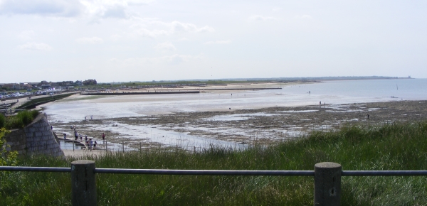
Today’s image for Day 332 of the VM_365 project shows the farmhouse of Lower Gore End Farm, Minnis Bay, Birchington which was established around 1540 or earlier.

Old Bay Cottage along with Elder Cottage formed the farmhouse of Lower Gore End Farm, all that remains of this farmstead which would originally have been isolated,  away from the focus of the village at Birchington to the east.

The farmhouse was originally detached and was located with its gable end facing on to the farmyard. Historic maps indicate that working farm buildings were located on two sides of the farmyard which faced side on to the route from the village of Birchington to Minnis Bay, now known as Minnis Road.

Old Bay Cottage, on the right of the image, is the oldest part of the farmhouse and was built in the 15th century as a two storey timber framed cottage with a tiled hipped roof and close studded timbers. The porch, which is just visible, was a later addition. The thatched roof visible on the left side of the image belongs to the 18th century extension known as Elder Cottage.

Lower Gore End Farm was quite isolated in the early to mid 19th century and surrounded by agricultural land, with Minnis Creek nearby still flooding nearly as far as the farmstead at the spring tides. It was probably still possible to have a clear view of the parish church of All Saint’s, Birchington from the farm although by the 1870’s new roads were beginning to be laid out at Minnis Bay, west of the relatively new railway line and brickfields were beginning to encroach on the agricultural land. By the late 19th century the farm was nearly surrounded by brickworks and by the 1950’s was surrounded on the north, east and west sides by suburban development focussed on Minnis Bay.

Nowadays the farmhouse is all that survives of the farmstead, completely surrounded by suburban development but still remains as an indicator of the once isolated rural character of Minnis Bay.