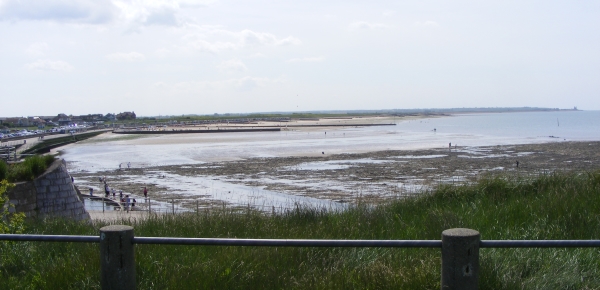
Today’s image for Day 334 of the VM_365 project shows a view of Minnis Bay, taken from the east, facing west toward Reculver. This view begins another short VM_365 series showing you our Thanet; the historic isle that we as archaeologists see around us.
Before the Bronze Age this landscape would have been significantly different. Sea levels were significantly lower than they are in the present day and much of the coastal area visible here would have been dry land. A freshwater creek extended along the approximate route of Minnis Road, just out of the picture to the right. The flat greyish green area of the beach visible in the foreground are the remnant of chalk cliffs that once formed the edge of the valley the creek flowed through, which has been eroded to a flat platform by the sea pushing into the creek mouth in the later prehistoric period.
Many prehistoric finds including Palaeolithic and Neolithic worked flint have been found off this foreshore, the tools used by the people who once lived on the land that has been lost to the sea. The remains of a Bronze Age settlement was discovered on the wave cut platform around the mouth of the creek in 1938. A Bronze Age hoard discovered in one of the pits has previously featured on Day 202 of the VM_365 project.
Beyond the wooden groynes that can be seen in the middle ground of the image is the former northern mouth of the Wantsum Channel, which became more significant as the sea advanced from the Bronze Age onward and separated what would become known as the Isle of Thanet from the mainland of Kent.
The sea continued to eat away at the land that was occupied by communities in later periods. The bases of Late Iron Age and Roman pits and other features, possibly wells, have also been identified as truncated pits on the wavecut platform on the foreshore. Artefacts retrieved from these pits included a Roman millstone, a two handled wine jar, and a colour coated dish.
Eroding pits and archaeological features of Late Iron Age and Roman date have been identified in the eroding cliff edges at Minnis Bay. On the horizon on the far right of the image is the site of a Roman fortress built on land at Reculver, overlooking the mouth of the Wantsum Channel and the west coast of the Isle of Thanet. The Fort and the settlement associated with it is beginning to be claimed by the sea. Coastal erosion has exposed the bases of Roman wells which are sometimes visible at low tide on the wave cut shelf at Reculver.
Reculver was also the site of one of the earliest and most important Anglo Saxon monasteries. The former monastery and the church that now stands at Reculver were built on the site of the Roman Fort and elements of all these structures have been revealed in a long series of archaeological excavations.
The vantage point of the cliff top at Minnis Bay provides a view of thousands years of Thanet’s history which the archaeologist’s eye can distinguish from the natural landscape.