Category Archives: Neolithic

VM_365 Day 363 Guest VM curator on (mostly) Prehistoric Ceramics

VM 363Today’s image is another in our series of roundups of posts contributed by our guest curators. This time we are looking at the posts Nigel Macpherson Grant contributed, mainly about prehistoric ceramics. Many of our posts have been based on his extensive knowledge and the detail published in reports and so much material in the VM_365 is based on his work.

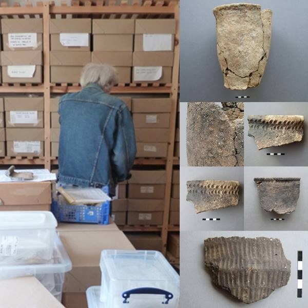
A report from an archaeological specialist could appear to be a dry prospect for the average reader, but Nigel’s are always filled with nuggets of information about the potters art or the patterns in form, fabrics and techniques current at any time which make for interesting posts for the VM project. On the left hand side of the picture is Nigel himself, who appeared in Day 2 of the VM 365 project, sorting through boxes in our store for more pottery examples.

On the right of the picture are several examples of the pottery pictures Nigel produced for us, always with an interesting story to tell about how they were made or how they might have been used. The first at the top was a previously unreported Bronze Age Urn which featured on Day 212 of the VM_365 project, the middle image that featured on Day 155, showed how ceramics were influenced by other materials, in this case the stitching on leather containers and the third image from Day 172, shows a finely decorated Neolithic bowl from Ramsgate.

Archaeology depends on the dedication of people who make the detailed study of a single type of artefact their life’s work and the contribution of our friend Nigel to Thanet’s archaeology is immeasurable and continues to grow.

Links to Nigel Macpherson Grant’s contributions to the VM_365 Project:

VM_365 Day 341 Unique vantage points and prehistoric sites

VM_341

The image for Day 341 is another in the series of Our Thanet posts, showing locations that play an important part in the exploration and appreciation of Thanet’s heritage.

The image shows a view taken facing south and south west from a downland hill top at Lord of the Manor, Ramsgate when part of the ring ditch associated with a Bronze Age round barrow was partly exposed in a training excavation in 2013.

Although it is partly obscured by trees and buildings that have grown up since a railway cutting was pushed through the chalk hillside in 1847, it is still possible to see the vista across the low lying bay that could be seen from the vantage point of the raised central platform enclosed by the ring ditch. From the centre of the mound the horizon falls away in a wide sweep from the north east to the south, giving a view across Pegwell Bay.

It can be no coincidence that a location commanding such an impressive view was chosen for the location of  such a major monument in the Bronze Age. Everywhere on Thanet where such unique points which command similar impressive views over the landscape can be found, there are also concentrations of prehistoric monuments, some unusually large in size or very complex such as the Lord of the Manor 1 multi phase monument which featured all the way back on Day 21 of the VM_365 project. Artistic reconstructions of the development of the landscape over time featured in an earlier series of VM_365 posts starting on Day 265.

This unique landscape is increasingly under pressure from development and it may soon not be possible to see what the prehistoric inhabitants of the Isle could see from the vantage points of the downland hilltops.

VM_365 Day 340 Holly Lane, West Northdown

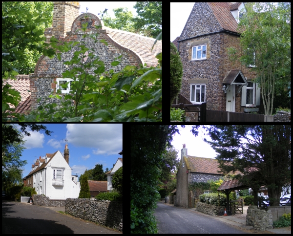
VM 340Today’s image for Day 340 of the VM_365 project shows a series of images of another of our Hidden Hamlets in Thanet, located around Holly Lane at West Northdown, Cliftonville.
Holly Lane is located a short distance south of Omer Avenue which featured on Day 338 of the VM_365 project. Before the area aroiund Holly Lane became part of the residential suburbs of Cliftonville, it was occupied by two farms; Hospital Farm and West Northdown Farm, which later became Holly Farm. Between 1907 and the 1930’s the area around both farms began to be in-filled with residential housing as agricultural land was sold off. Hospital Farm was completely demolished. By the 1960’s most of the area around Holly Lane was completely in-filled.

Evidence of its former isolated and agricultural character still exists along Holly Lane and Old Green Road. The oldest building, Grapevine Cottage (top left), is located in Holly Gardens, set back off Holly Lane and is believed to date from 1620 or earlier. It was originally two labourers cottages constructed of brick with curved end gables.  In the 20th century the building was altered to become a single house.

Other evidence of the 18th and 19th century agricultural origins exist in the form of flint boundary walls and flint and brick cottages.

VM 365 Day 334 The landscape of Minnis Bay

VM 334

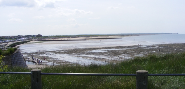
Today’s image for Day 334 of the VM_365 project shows a view of Minnis Bay, taken from the east, facing west toward Reculver. This view begins another short VM_365 series showing you our Thanet; the historic isle that we as archaeologists see around us.

Before the Bronze Age this landscape would have been significantly different. Sea levels were significantly lower than they are in the present day and much of the coastal area visible here would have been dry land.  A freshwater creek extended along the approximate route of Minnis Road, just out of the picture to the right. The flat greyish green area of the beach visible in the foreground are the remnant of chalk cliffs that once formed the edge of the valley the creek flowed through, which has been eroded to a flat platform by the sea pushing into the creek mouth in the later prehistoric period.

Many prehistoric finds including Palaeolithic and Neolithic worked flint have been found off this foreshore, the tools used by the people who once lived on the land that has been lost to the sea.  The remains of a Bronze Age settlement was discovered on the wave cut platform around the mouth of the creek in 1938. A Bronze Age hoard discovered in one of the pits has previously featured on Day 202 of the VM_365 project.

Beyond the wooden groynes that can be seen in the middle ground of the image is the former northern mouth of the Wantsum Channel, which became more significant as the sea advanced from the Bronze Age onward and separated what would become known as  the  Isle of Thanet from the mainland of Kent.

The sea continued to eat away at the land that was occupied by communities in later periods.  The bases of Late Iron Age and Roman pits and other features, possibly wells, have also been identified as truncated pits on the wavecut platform on the foreshore. Artefacts retrieved from these pits included a Roman millstone,  a two handled wine jar, and a colour coated dish.

Eroding pits and archaeological features of Late Iron Age and Roman date have been identified in the eroding cliff edges at Minnis Bay. On the horizon on the far right of the image is the site of a Roman fortress built on land at Reculver,  overlooking the mouth of the Wantsum Channel and the west coast of the Isle of Thanet.  The Fort and the settlement associated with it is beginning to be claimed by the sea. Coastal erosion has exposed the bases of Roman wells which are sometimes visible at low tide on the wave cut shelf at Reculver.

Reculver was also the site of one of the earliest and most important  Anglo Saxon monasteries. The former monastery and the church that now stands at Reculver were built on the site of the Roman Fort and elements of all these structures have been revealed in a long series of archaeological excavations.

The vantage point of the cliff top at Minnis Bay provides a view of thousands years of Thanet’s history which the archaeologist’s eye can distinguish from the natural landscape.

VM_365 Day 282 Old meets new at Pegwell

VM 282

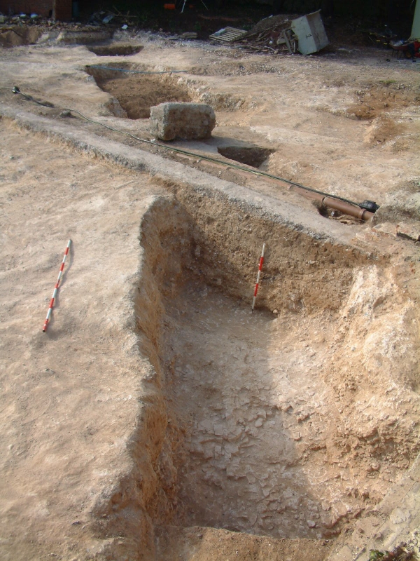
Today’s image for Day 282 of the VM_365 project shows the segment of a Neolithic causewayed enclosure that was excavated in 2007 at Courtstairs, near Pegwell Bay. What is interesting in this picture is that you can see human activity on the site spanning a period of over 5500 years.

The earliest element is the linear cut of the Neolithic causewayed enclosure, formed by the excvavation of a continuous curving line of conjoined pits. The fills of the individual cuts containing pottery sherds shown on Day 172 including some from a round based vessel shown on Day 187; finely worked flint blades and bladlets shown on Day 171 and a flint sickle that was featured on Day 173, as well as animal bone, mainly representing large cattle species.  A cow skull that featured on Day 186 was found at the base of one of the pits forming the enclosure and was carbon dated to 3636-3625 cal. BC.

Jump forward over 5000 years and you can see the concrete footing for a building that most recently occupied the site, its foundations cutting the fills of the Neolithic enclosure.  Alongside the linear concrete foundation was a drainage trench containing a modern drain and an electricity cable. In the background you can see the blue plastic pipe supplying mains water to a nearby building.

Until the early 19th century the Isle of Thanet was sparsely populated and had little development on the rolling chalk hilltops overlooking the coast, which may have attracted the Neolithic settlers to the site. The explosion of seaside suburban development has hidden many of our most significant prehistoric sites under the foundations and gardens of Thanet’s coastal towns. On rare occasions archaeologists are able to uncover some of these sites for investigation.


VM_365 Day 266 The barrow reconstruction drawings get more complicated

VM 266

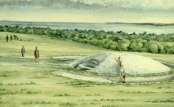
The image for Day 266 of the VM_365 project is the second in a series of images drawn by Dave Perkins, reconstructing the sequence of event associated with a funerary monument that was revealed in excavations at Lord of the Manor, Ramsgate.

In today’s image, the single ring ditch and mound that was shown in yesterday’s picture is being renewed, ready to receive another burial. The original ring ditch and its mound, now compressed and discoloured, have been sealed under fresh chalk which is being dug from a new ring ditch with a greater diameter than the earlier one. The circuit of the new ditch is  interrupted by a causeway, where a stretch of the circuit was not excavated. It is a process like this that created the concentric circuits of ditches that show up so well in the cropmark posted on VM_365 Day 264.

The location of the barrow is closely based on the landscape of the Lord of The Manor site, with the land falling away into a deep dry valley, which is shown covered with woodland. The sweep of the valley leads to the sea at Pegwell Bay in the upper right hand side of the picture. On the left side of the image a funeral procession is making its way up the side of the valley toward the newly refurbished barrow.

It is still possible in the present day to stand near the site of the barrow and see the same view over the bay which would have been presented to the prehistoric people of the area.  It was this experience of the landscape that Dave Perkins used to draw his reconstruction images.

Further analysis of the landscape has shown that there are only a few sites in Thanet’s landscape where such an uninterrupted view is possible and it becomes clear from considering the landscape that sites were carefully chosen to provide such a panoramic view. Excavations have shown that some were used over many thousands of years to locate settlements, gather for ceremonies and to create structures where the dead could be buried.

Once again we can reconstruct the facts that are presented by the archaeological features on the ground, but can never really confirm the reasoning behind the choice of location which is so well captured in the drawing. Was it to assert a power or domination over the landscape or to enhance the visibility of the monument from other sites? Motives may have changed over time passing from willful choice into tradition whose meanings were lost in the passage of time.

The true motives are lost without the record of contemporary voices, but we can explore possible meanings through attempts at reconstruction like the drawings in this series of posts. There are questions to ask about this reconstruction: was the natural environment so open and free of the influence of man as it is shown? Was it as simple a task to create a barrow as is suggested? The ring ditches of the many barrows that have now been excavated in Thanet have demonstrated that they are often perfectly circular with regular and symmetrical profiles throughout the circuit, despite the hard chalk rock that had to be cut to create them. It is immediately possible to suggest the picture could be made more accurate with the addition of some figures carrying out some quite complex surveying and architectural control over the cutting of the ditch as well as an indication of the greater amount of labour that went into cutting away the chalk in such quantity. Our ideas progress through such criticisms of the reconstruction, which perhaps leads in the future to new images that take new ideas on board. Sadly they will not have the benefit of Dave Perkins’ wisdom and experience to inform them.

VM_365 Day 264 Cropmarks record ancient Ramsgate landscape

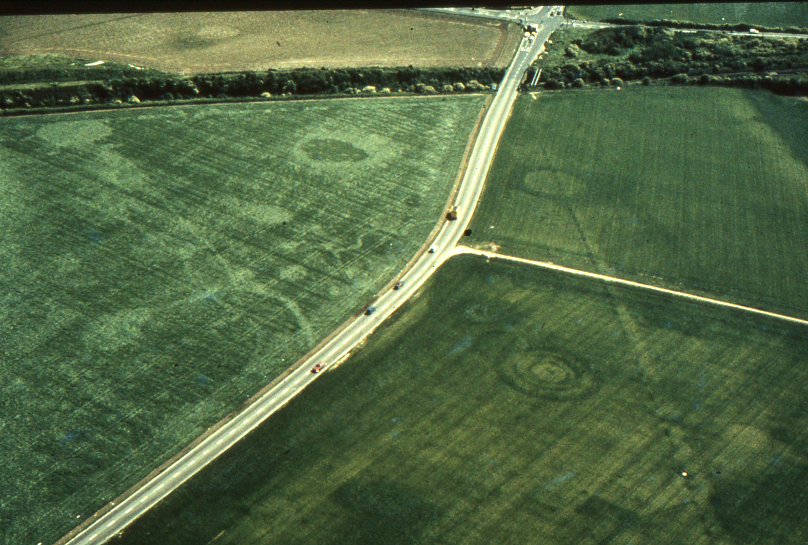
VM 264Today’s image for Day 264 of the VM_365 project shows an aerial photograph of one of the most impressive groups of crop mark groups in Thanet’s historic landscape. The picture was taken in the the late 1970’s, from an aeroplane flying over the downland ridge at Lord of the Manor, Ramsgate overlooking Pegwell Bay.
In the photograph, which is facing south east toward Ramsgate, a chalk ridge extends from the lower right corner of the picture toward the top left. The ridge is isolated by the dry valleys that flank it on the right and left hand sides, affording spectacular views over the coastline to the south .

The overflight to photograph the cropmarks took place before several major developments in the road network in the immediate area took place, preserving a record of the  landscape despite the considerable changes  that have happened in recent years. The linear markings and circular shapes that can be seen through the variations in the colour of the crops growing in the field, indicate the locations of buried archaeological features and sites, which have been investigated in many phases of archaeological investigations that were guided by the location of the crop marks since the photograph was taken. The effect of buried archaeological sites  which produced the variations in colour in the growing crop was explained in a drawing produced by Dave Perkins in our VM_365 post for Day 252.

At the junction between a road and a railway cutting that can be seen at the top right of the picture, one of the earliest published archaeological investigations was conducted by William Rolfe, Thomas Wright and Charles Roach Smith, when an Anglo-Saxon cemetery was disturbed by the railway cutting in 1846.  A drawing made of one of the graves was shown on VM_365 Day 225. The Saxon cemetery and the more ancient Bronze Age ring ditches that had occupied the ridge, continued to be investigated in several stages in the later 20th century.  Images of some of the excavations of the Anglo-Saxon cemetery that were carried out in the 1980’s were shown in the VM_365 posts for Day 216 and Day 217.

The three concentric ring ditches of a multi-phase monument, which was first constructed in the Neolithic period and was renewed in the Beaker and Bronze Age periods, can be seen in the bottom right part of the image. A view of the partial excavation of the three ring ditches in 1976 was shown in the image for Day_21.

Archaeological work in this landscape has continued to be carried out with the ditches of an Iron Age settlement being explored in 2012 and in a  training excavation carried out as recently at 2013.


VM_365 Day 214 Neolithic Serrated Flint blade from Margate

VM 214

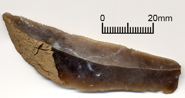
The VM_365 project’s image for Day 214 is a fine, serrated flint blade excavated from a pit dating to the Neolithic period on a site near Margate Railway Station in 2004.

The  blade is fine, partly-worn and serrated along both edges with approximately 11 serrations per 10mm.  The fine blade shows some wear indicating that it has seen some use. It has a break at the proximal-end which has removed the striking platform and crushing along the ridge of the blade along with a couple of notches taken out of one edge suggest that the blade had been hafted or mounted on a handle.

The fine serrations distributed so regularly along both edges of this blade attest to the skill and craft of the Neolithic flint worker.


VM_365 Day 210 Barbed and Tanged arrowhead from Laundry Road, Minster

VM 210

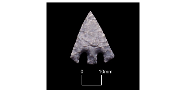
The image for Day 210 of the VM_365 project is another taken from our slide archive.

The object shown is a Late Neolithic flint tanged and barbed arrowhead, found in the fill of a segment excavated through an enclosure at Laundry Road, Minster in 1995. Another ditch section contained pottery dating to the Beaker period, suggesting that the whole enclosure was of late Neolithic/Early Bronze Age date.

Other similar flint arrowheads from locations in Thanet have been featured in previous VM_365 posts, on Day 141, Day 162, and Day 168.

VM_365 Day 187 Neolithic round based vessel from Courtstairs

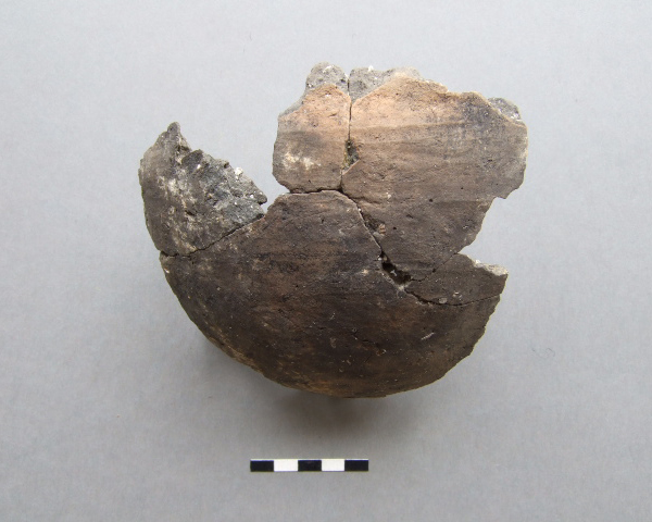
VM 189For today’s VM_365 image, on Day 187, we have another of the Neolithic vessels from Courtstairs, near Pegwell Bay, whose dating was supported by the  carbon dated cow skull shown for Day 186.  The picture shows a small, nearly complete round-based coarseware bowl, sadly without its rim.
The first pottery manufactured in the Neolithic period often had rounded bases, meaning that they would not stand on their own without being held upright or propped on some form of frame. It is likely that this property emerged from the round based collecting baskets which were the skeuomorphic models for the vessel shapes and the decoration that was added to them.
Humans developed tools to extend the capabilities of their limbs and organs, creating and experimenting with new objects and implements. We may, with hindsight, trace innovations as a progression of developments toward the most modern examples we know. However, when a new material is being explored, many uses and variations may be experimented with until the whole range pf possible functions and properties are developed.
Innovations eventually become embedded in our experience as the obvious and expected properties of a manufactured object, like a flat bottom in a pottery vessel, which may have appeared unlikely and unnecessary to the early innovators.