Category Archives: Birchington

VM_365 Day 339 Downland landscape of Birchington

VM_339

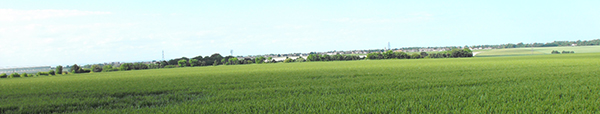
The image for today, Day 339 of the VM_365 project, is a north west facing view of the historic downland landscape of Birchington. The view of the horizon beyond the cornfields stretches from the complex of Glasshouses at Thanet Earth on the left side to the tree enclosed Quex Park on the right.

All across this landscape in the ripening corn, the secrets of the archaeology below the ground are revealed in a mass of cropmarks. Some of the earliest images of archaeological sites revealed by cropmarks were aerial views of this very landscape published by OGS Crawford, known as the father of aerial archaeology, in the Journal Antiquity in 1934.

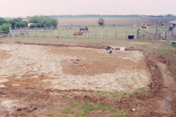
Excavations in advance of the construction of the Thanet earth glasshouses gave an opportunity to investigate a set of the largely unexplored crop marks in the landscape. Archaeological features from the Neolithic, Bronze Age, Roman, Anglo-Saxon and even modern periods were revealed as each greenhouse was built.

The Iron Age settlement of the landscape stretches far across the rolling hilltops and one of the most remarkable discoveries of the era was of a large hoard of Iron Age potin coins discovered when trees were planted to surround the newly enclosed Quex Park in the 1853. The remaining unexplored landscape almost certainly holds archaeological evidence of the same range of dates in the wide sweep of linear features and circular enclosures that can be seen in aerial views.

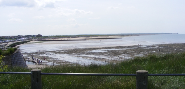
Standing archaeology visible in today’s picture includes the spire of the Parish Church of All Saints at Birchington near the middle of the picture and on the far right the historic Gun Tower within the grounds of Quex Park. Beyond the horizon in the image is the coast at Minnis bay, whose remarkable archaeological landscape was itself explored on Day 334 of the VM_365 project.

VM 365 Day 334 The landscape of Minnis Bay

VM 334

Today’s image for Day 334 of the VM_365 project shows a view of Minnis Bay, taken from the east, facing west toward Reculver. This view begins another short VM_365 series showing you our Thanet; the historic isle that we as archaeologists see around us.

Before the Bronze Age this landscape would have been significantly different. Sea levels were significantly lower than they are in the present day and much of the coastal area visible here would have been dry land.  A freshwater creek extended along the approximate route of Minnis Road, just out of the picture to the right. The flat greyish green area of the beach visible in the foreground are the remnant of chalk cliffs that once formed the edge of the valley the creek flowed through, which has been eroded to a flat platform by the sea pushing into the creek mouth in the later prehistoric period.

Many prehistoric finds including Palaeolithic and Neolithic worked flint have been found off this foreshore, the tools used by the people who once lived on the land that has been lost to the sea.  The remains of a Bronze Age settlement was discovered on the wave cut platform around the mouth of the creek in 1938. A Bronze Age hoard discovered in one of the pits has previously featured on Day 202 of the VM_365 project.

Beyond the wooden groynes that can be seen in the middle ground of the image is the former northern mouth of the Wantsum Channel, which became more significant as the sea advanced from the Bronze Age onward and separated what would become known as  the  Isle of Thanet from the mainland of Kent.

The sea continued to eat away at the land that was occupied by communities in later periods.  The bases of Late Iron Age and Roman pits and other features, possibly wells, have also been identified as truncated pits on the wavecut platform on the foreshore. Artefacts retrieved from these pits included a Roman millstone,  a two handled wine jar, and a colour coated dish.

Eroding pits and archaeological features of Late Iron Age and Roman date have been identified in the eroding cliff edges at Minnis Bay. On the horizon on the far right of the image is the site of a Roman fortress built on land at Reculver,  overlooking the mouth of the Wantsum Channel and the west coast of the Isle of Thanet.  The Fort and the settlement associated with it is beginning to be claimed by the sea. Coastal erosion has exposed the bases of Roman wells which are sometimes visible at low tide on the wave cut shelf at Reculver.

Reculver was also the site of one of the earliest and most important  Anglo Saxon monasteries. The former monastery and the church that now stands at Reculver were built on the site of the Roman Fort and elements of all these structures have been revealed in a long series of archaeological excavations.

The vantage point of the cliff top at Minnis Bay provides a view of thousands years of Thanet’s history which the archaeologist’s eye can distinguish from the natural landscape.

VM 365 Day 332 Lower Gore End Farm, Minnis Bay

VM 332
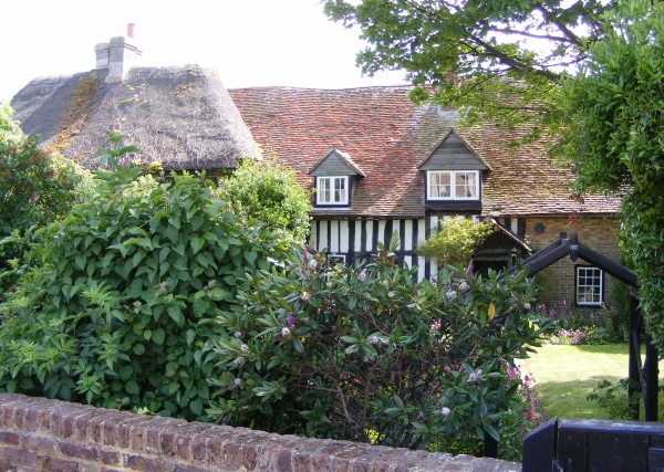
Today’s image for Day 332 of the VM_365 project shows the farmhouse of Lower Gore End Farm, Minnis Bay, Birchington which was established around 1540 or earlier.

Old Bay Cottage along with Elder Cottage formed the farmhouse of Lower Gore End Farm, all that remains of this farmstead which would originally have been isolated,  away from the focus of the village at Birchington to the east.

The farmhouse was originally detached and was located with its gable end facing on to the farmyard. Historic maps indicate that working farm buildings were located on two sides of the farmyard which faced side on to the route from the village of Birchington to Minnis Bay, now known as Minnis Road.

Old Bay Cottage, on the right of the image, is the oldest part of the farmhouse and was built in the 15th century as a two storey timber framed cottage with a tiled hipped roof and close studded timbers. The porch, which is just visible, was a later addition. The thatched roof visible on the left side of the image belongs to the 18th century extension known as Elder Cottage.

Lower Gore End Farm was quite isolated in the early to mid 19th century and surrounded by agricultural land, with Minnis Creek nearby still flooding nearly as far as the farmstead at the spring tides. It was probably still possible to have a clear view of the parish church of All Saint’s, Birchington from the farm although by the 1870’s new roads were beginning to be laid out at Minnis Bay, west of the relatively new railway line and brickfields were beginning to encroach on the agricultural land. By the late 19th century the farm was nearly surrounded by brickworks and by the 1950’s was surrounded on the north, east and west sides by suburban development focussed on Minnis Bay.

Nowadays the farmhouse is all that survives of the farmstead, completely surrounded by suburban development but still remains as an indicator of the once isolated rural character of Minnis Bay.

VM_365 Day 323 The parish church of All Saints, Birchington.

VM 323
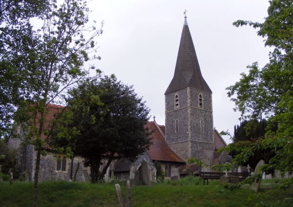
The image for Day 323 of the VM_365 project shows the parish church of All Saints, Birchington. The church is located on high ground approximatley 1.2 km (¾ mile) from the coast and although now  heavily built up,  the landscape would have been open all the way down to the sea until around the mid 19th century. The churchyard is large and open and has been terraced along the hillside to accomodate the 19th century extension to the graveyard.

The church was a chapel to the church at Monkton along with Woodchurch/Acol and was part of the possessions of Christ Church Priory, Canterbury until the Dissoloution when it was passed to the Dean and Chapter of Canterbury.

All Saints was constructed in the 12th century or earlier using flint and Caen stone and had already been aisled by the late 12th century. The earliest surviving fabric exists in the lower outer aisle walls, with some reused Caen stone blocks in the upper face of the south west aisle and the south doorway, although restored in the 1860’s, retains two capitals dating to the later 12th century. Two of the reused blocks may be from the tops of earlier Norman windows associated with the phase before the construction of the aisles.

The chancel was rebuilt in the earlier 13th century, flanked by two new chapels to the north and south and a new tower was constructed. The south chapel, dedicated to St Margaret extended under the tower, the chapel on the north side was dedicated to Our Lady. Both chapels were later dedicated to the Crispe and Quex families.

The nave arcades were rebuilt in the 1340’s and a new chancel arch added using flint and Rag stone. The 14th century north doorway, which was blocked in the 1860’s still survives. Most of the later medieval features were removed from the church probably when the whole of the exterior of the church was heavily refaced and ‘restored’ in the 1860’s using flint and Bathstone. New vestries were added to the south east of the church in 1910-11.

The founder of the Pre-Raphelite movement, Dante Gabriel Rossetti; poet, painter and illustrator, died at Birchington in 1882 and is buried in the churchyard. His monument is located near the south porch.

References/Further Reading

Berg, M. and Jones, H.  2009. Norman Churches in the Canterbury Diocese. The History Press.

Tatton-Brown, T. 1996. All Saints Church, Birchington. Canterbury Diocese: Historical and Archaeological Survey. http://www.kentarchaeology.org.uk/01/03/BIR.htm

VM_365 Day 318 Jug from Medieval Farmer’s Table

VM 318
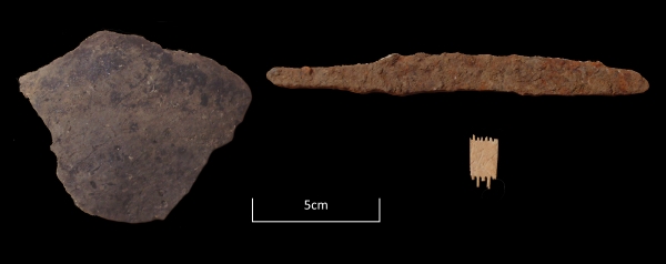
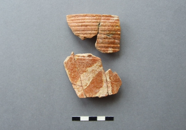
The image for Day 318 of the VM365 project shows sherd fragments from a medieval tableware jug found in 1979 in an excavation at Netherhale Farm, Birchington.

The late David Perkins conducted a trial excavation  to test the cropmarks of a double ditched enclosure on land between Birchington and St.Nicholas-at-Wade. The excavation revealed a Mid-Late Bronze Age farmstead enclosure (c.1350-1150 BC) underlying a medieval farmstead  enclosed with a ditch. This site could possibly be the medieval forerunner of the modern Netherhale Farm which stands  just to the north of the site.

The cropmarks lie on a very slight knoll and presumably was chosen in both periods of settlement for its well-drained position. Apart from some deeply cut ditches and pits, the ditches and the settlement they enclose have been heavily plough-reduced.

The Medieval phase of occupation produced the fragments from the tableware jug shown above which are from a fairly tall ovoid-bodied jug.  The rim is shown in the upper part of the image, with a horizontally incised neck below and the upper shoulder and body has been painted in white slip with vertical and diagonal stripes under a clear orange (iron) glaze over.

The jug was made at the Tyler Hill potteries near Canterbury and the form, type of decoration and the firing qualities date its manufacture to between c.1250-1325 AD,  a period known in art-historical terms as the ‘High Medieval’ .

Although this vessel is perhaps not as constructively creative as the Scarborough Ware ‘knight’ Jug or the south-west French polychrome-painted jug which were contemporary with this example,  its striking colours and design would have made a handsome addition to the farmstead’s dinner table.

VM_365 Day 313 Colour coated dish from Minnis Bay, Birchington

VM 313
After P. H. G. Powell-Cotton and G. F. Pinfold, 1939, Plate IV.

Today’s image for Day 313 of the VM_365 shows half of a Roman pottery bowl found in one of the pits excavated and recorded by James Beck and Antoinette Powell-Cotton at Minnis Bay, Birchington in 1938.

The bowl, described as a half of a red ware colour coated dish, was found in the same pit as the double handled wine jug featured in yesterday’s post for Day 312 of the VM_365 project. Half of a 4th century black pottery vessel, fragments of millstones and part of an upper quern stone were also found in the pit.

VM_365 Day 312 Roman pottery from pits on foreshore at Minnis Bay

VM 312
After P. H. G. Powell-Cotton and G. F. Pinfold, 1939, Plate III.

Today’s image for Day 312 of the VM_365 project shows three Roman pottery vessels found and excavated by James Beck and Antoinette Powell-Cotton in pits on the foreshore of Minnis Bay, Birchington in 1938.

The vessel on the left hand side of the image was found in a square shaped pit and is described as a ‘grey Belgic vase’ by Major Powell-Cotton and G. F. Pinfold in their report and catalogue of the site in 1939. This late Iron Age/Early Roman vessel was found along with the base of a 1st century rough cast pottery beaker and a fragment of Quern stone.

The vessel shown in the centre of the picture is described  as a two handled wine jar of New Forest type.  A wide range of wheel thrown fine wares were produced in the New Forest  in the 3rd and 4th century,  sometimes decorated as is the case with this vessel, and are generally found distributed across southern Britain. The vessel was found complete, in a pit along with some other pottery and a fragment of the upper part of a quernstone.

The vessel on the right was found in a pit beneath the millstone that featured in yesterday’s, Day 311 post for VM_365. The vessel was described as a fine red ware pot with the remains of decoration with white slip.

Some of the pits may be the remains of the bottoms of well as three contained springs. The pottery found in the pits dates from the early 1st century to the 3rd or 4th century indicating that this area had been a focus of activity by the Romans for at least 300 years.

VM_ 365 Day 311 Roman millstone from a pit at Minnis Bay.

VM 311
After P.H.G Powell-Cotton and G. F. Pinfold, 1939.

Today’s image for Day 311 of the VM_365 project shows a large Roman Millstone found on the foreshore at Minnis Bay in 1938 by a 14 year old schoolboy named James Beck. The picture of the millstone was taken at the Powell-Cotton Museum where the millstone now resides.

James Beck identified and excavated a group of eight pits of Roman date assisted by Antoinette Powell-Cotton. The millstone, measuring nearly a metre in diameter and almost 12 centimetres thick, was found covering one of the pits, an irregular shaped cut which measured about 73 centimetres deep. A fragment of millstone of a similar date found at Broadstairs previously featured on Day 59 of the VM_365 project. Below the millstone, the pit also contained a fine red ware vessel, two fragments of samian pottery, horses teeth and fragments of wood.

James Beck also identified a Bronze Age site in the same area as the group of Roman pits and excavated and recorded a Bronze Age hoard that was previously featured on Day 202 of the VM_365 project.


VM_365 Day 309 Artefacts from Anglo Saxon SFB at Woodchurch.

VM 309

Today’s image for Day 309 of the VM_365 project shows a selection of three artefacts which were found in the small segment excavated through the Anglo Saxon Sunken Featured Building from Woodchurch, Thanet that featured in yesterday’s VM_365 post for Day 308.

On the left hand side of the image is a sherd of Organic-tempered ware pottery of early to Mid Saxon date (c. 550/600 – 700 AD).

On the right hand side at the top of the image is an Iron Knife with a curved ‘hog-back’ blade, with a curved cutting edge that may be the result of repeated sharpening on a round section hone.

The small fragment of comb at the bottom of the image has been carved from bone and is from a one-piece double-sided comb. The spacing of the teeth is different on each side, suggesting that it had both a fine and coarse combing side.

VM_365 Day 308 Anglo Saxon SFB at Woodchurch, Thanet

VM 308

Today’s image for Day 308 of the VM_365 project shows a common type of archaeological feature of  Anglo Saxon date, known as a Sunken Featured Building, which was uncovered during an evaluation carried out in advance of the construction of a house at Woodchurch, Birchington in 2002. The picture is taken looking across the valley from Woodchurch toward the tree lined boundary of Quex Park. This is post is another example of a small keyhole investigation which has revealed important information without extensive excavation.

The depth of overburden above the chalk was less than 10 centimetres deep and so the entire footprint of the building was stripped to expose the chalk and reveal archaeological features. The Sunken Featured Building (usually shortened by archaeologists to the initials SFB) can just be made out in the centre foreground of the picture as a rectangular patch of earth slightly darker in colour than the periglacial brickearth stripe to the north and on which the photographic scales are placed.

Because it was possible to move the foundations of the house to avoid the SFB, only a small segment was excavated through it.  Artefacts recovered from the small area excavated included an Iron knife, a sherd of pottery and a small fragment from a double sided bone comb, which date the SFB from the mid to late 6th to 7th century.

Evidence of Anglo Saxon settlement is relativley rare in Thanet, compared to the known locations of cemeteries of this date. Other Sunken Featured Buildings have featured in previous VM_365 project posts, one from Margate on Day 83 and one from Sarre on Day 229.

The SFB at Woodchurch was abe to be preserved in situ and now survives below the lounge of the property.