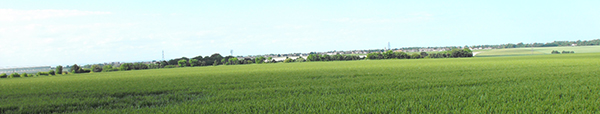
The image for today, Day 339 of the VM_365 project, is a north west facing view of the historic downland landscape of Birchington. The view of the horizon beyond the cornfields stretches from the complex of Glasshouses at Thanet Earth on the left side to the tree enclosed Quex Park on the right.
All across this landscape in the ripening corn, the secrets of the archaeology below the ground are revealed in a mass of cropmarks. Some of the earliest images of archaeological sites revealed by cropmarks were aerial views of this very landscape published by OGS Crawford, known as the father of aerial archaeology, in the Journal Antiquity in 1934.
Excavations in advance of the construction of the Thanet earth glasshouses gave an opportunity to investigate a set of the largely unexplored crop marks in the landscape. Archaeological features from the Neolithic, Bronze Age, Roman, Anglo-Saxon and even modern periods were revealed as each greenhouse was built.
The Iron Age settlement of the landscape stretches far across the rolling hilltops and one of the most remarkable discoveries of the era was of a large hoard of Iron Age potin coins discovered when trees were planted to surround the newly enclosed Quex Park in the 1853. The remaining unexplored landscape almost certainly holds archaeological evidence of the same range of dates in the wide sweep of linear features and circular enclosures that can be seen in aerial views.
Standing archaeology visible in today’s picture includes the spire of the Parish Church of All Saints at Birchington near the middle of the picture and on the far right the historic Gun Tower within the grounds of Quex Park. Beyond the horizon in the image is the coast at Minnis bay, whose remarkable archaeological landscape was itself explored on Day 334 of the VM_365 project.