Category Archives: Thanet’s Heritage Pioneers

VM_365 Day 346 What about the box? Imports from Colchester.

VM 346

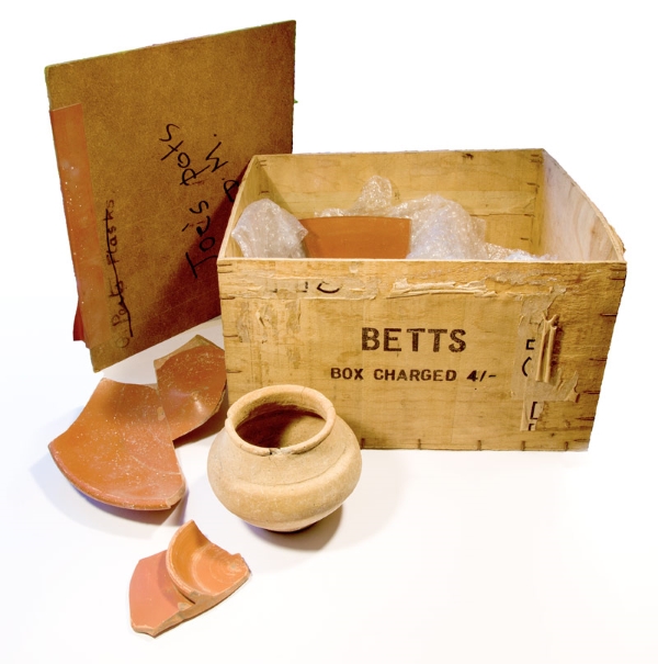
Today’s image for Day 346 shows the wooden box that was used to store some of the Roman pottery excavated at the Roman building near Drapers Mill by Joe Coy in the late 1950’s and 1960’s which featured in yesterday’s VM_365 post for Day 345. The wooden box holding Joe Coy’s Roman pottery dates to the late 1950’s – 1960’s, comtemporary with the time the dig at Drapers Mill was carried out and itself has a story to tell us.

Museum stores house thousands of artefacts and when visiting the stores it is often not long before you see an old tobacco tin, wooden matchbox and the like from the 20th century that had been pressed into service as a make-do receptacle for a find. This was a time when Tupperware, cardboard and plastic wrapping were generally less common and before there were stricter museum curation policies (that specify how materials are to be received by the curating museum). So, just as with a visit to the family shed, you can see how, what were familiar items of recent times, were opportunistically utilized for safe storage.

Coming across such containers can jog the memory and be a fascinating encounter as sometimes what was ubiquitous, valueless and discardable packaging, say 70 years ago, now has a story to tell. Occasionally this is as insightful as the artefact within. In those times we consumed less, things were less easy to replace, and there was more of an attitude of ‘make-do and mend’; what items came in were often carefully designed and very well-made: here was a chance for the prudent 20th century recycler to find a new use for old packaging. What was to hand was helpfully taken into service, not so much to save cash but more likely because there were limited alternatives.

We only have to go back a few decades to the 1960s to be within that time and we can see that Joe Coy’s best pottery finds from the excavations at Drapers Mills from the turn of that decade came to be housed in a robust wooden box convenient for shelving and for transport for when the finds were needed for display or to show the pottery experts.

The box is made of thin ply-wood and its measurements and markings are in imperial standards for it pre-dates the switch to decimalization in 1971. Accordingly it measures 11 by 10 inches and has a height of 6¾ʺ. It had been marked in now fading black-ink by stencilling or stamping with the name ‘BETTS’. It was seen recently by Pete Nash who recognized it immediately as coming from the Betts toothpaste tube factory at Colchester.

Also marked on one side (more obviously by stencilling and in a different type-face) are the contents, described in light traces as ‘TUBES’ with what is likely to be the quantity given but which cannot now be read clearly. The price is given by means of the same stencil as ‘BETTS’ telling the reader ‘BOX CHARGED 4/-’ in what we call nowadays ‘old money’ namely four schillings (20p in today’s decimal currency). The ply-wood is ⅛ of an inch thick, with metal staples used to bind the sheets together. This makes for a container it is very sturdy but light and doubtless the dimensions relate to the size of the tubes inside and their safe transit and housing.

The tubes of toothpaste originally stored in the box were almost certainly of soft metal and shorter than today, so may have sat in two rows within the box. Masking-tape had been added at a later stage, probably to secure an improvised lid as the original top is missing (was that perhaps used in a role as a tray as we might use a shoe box lid today or had it been broken on opening?). Did the original lid say more about the content? A makeshift lid was provided when it was pressed into service to store the pottery, perhaps in the 1960s or 1970s, made of ‘hardboard’ which is another material that was ubiquitous at the time, being used in light carpentry, but now rarely seen. This was also something likely to be simply convenient to hand which has been cut to just lie over the top of the box. It too is inscribed, but this time with summary information on the present contents and in marker pen, short and to the point “Joe’s pots DM.”

Aptly the box and perhaps what it originally held were imports to Thanet, just as it contains imports from the Roman era in its present use. One of these, a whole globular beaker, as featured in yesterday’s post for Day 346 of the VM_365 project, is a type known from Roman Colchester, one that may have been made there, which would be a striking coincidence.

Of course the reuse of former packaging is well-attested through the ages: from Roman wine and oil amphorae seen reused as caskets for burials (with examples known on Thanet and in north-east Kent) to the tea-chests which were an everyday item seen in second use in ‘storage and removal’ through the second half of the 20th century. Doubtless old jam jars will be employed for new home-made jams this summer, some maybe first had jam from Tiptree, near Colchester.

The Betts factory which was still operating in the 1960s closed to be redeveloped recently for housing. Joe Coy’s box has become an artefact and its history ties it in time to the important excavations at Drapers Mills that occurred when the box was itself young. What happened to all the thousands of other boxes of this type dispatched from the Betts factory and are there other surviving examples from Thanet?

Dr Steven Willis (University of Kent), Photo: Lloyd Bosworth (University of Kent). Thanks to Pete Nash of Colchester.

VM_365 Day 339 Downland landscape of Birchington

VM_339

The image for today, Day 339 of the VM_365 project, is a north west facing view of the historic downland landscape of Birchington. The view of the horizon beyond the cornfields stretches from the complex of Glasshouses at Thanet Earth on the left side to the tree enclosed Quex Park on the right.

All across this landscape in the ripening corn, the secrets of the archaeology below the ground are revealed in a mass of cropmarks. Some of the earliest images of archaeological sites revealed by cropmarks were aerial views of this very landscape published by OGS Crawford, known as the father of aerial archaeology, in the Journal Antiquity in 1934.

Excavations in advance of the construction of the Thanet earth glasshouses gave an opportunity to investigate a set of the largely unexplored crop marks in the landscape. Archaeological features from the Neolithic, Bronze Age, Roman, Anglo-Saxon and even modern periods were revealed as each greenhouse was built.

The Iron Age settlement of the landscape stretches far across the rolling hilltops and one of the most remarkable discoveries of the era was of a large hoard of Iron Age potin coins discovered when trees were planted to surround the newly enclosed Quex Park in the 1853. The remaining unexplored landscape almost certainly holds archaeological evidence of the same range of dates in the wide sweep of linear features and circular enclosures that can be seen in aerial views.

Standing archaeology visible in today’s picture includes the spire of the Parish Church of All Saints at Birchington near the middle of the picture and on the far right the historic Gun Tower within the grounds of Quex Park. Beyond the horizon in the image is the coast at Minnis bay, whose remarkable archaeological landscape was itself explored on Day 334 of the VM_365 project.

VM_365 Day 315 Middle Iron Age Pottery lid used in slow cooking, Tivoli, Margate

VM 315

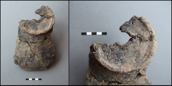
Today’s image for Day 315 of the VM_365 project  shows part of a Middle Iron Age flat and perforated handled lid for a cooking vessel  which came from a small excavation at Tivoli Park Avenue, Margate carried out by the Isle of Thanet Archaeological Society.

A series of small test pit excavations by the Isle of Thanet Archaeological Society were carried out in the mid-late 2000’s and were designed to find further traces of the Tivoli Roman ‘villa’  which featured  on Day 77 of the VM_365 project  and was previously recorded by Dr. Arthur Rowe.  Little material associated with the villa was recovered but instead the investigations produced a rare sequence of earlier Iron Age activity.

In the uppermost levels of the sequence, in descending order, there was a thin scatter of material confirming Anglo-Saxon, Early-Mid Roman and Late Iron Age activity. Beneath this were increasing quantities of Mid-Late iron Age material (c.200-50 BC), and then beneath that a chalk and cobble floor of, broadly Mid Iron Age date (c.350-200 BC) and, beneath that again, postholes and occupation soil datable to the Early-Mid Iron Age (c.600-350 BC).

One of the features associated with the Middle Iron Age floor produced the lid shown above in the picture on the left. It is part of a handled lid – with the rim at the bottom, and handle at top. The handle is flat and perforated (picture right) which means that the lid was used during the slow-cooking of vegetables or meat, over a relatively low heat.

Roughly made pot lids, using re-worked lower bodies of broken jars are not unknown from Iron Age sites – but a deliberately-made lid, with a ‘steamer-knob’, is rare and tends to confirm that at least in the Middle Iron Age more sophisticated cooking techniques were being employed than the simple roasting of a pig or other animal on a turned spit.

The information and images for this post were kindly provided by Nigel Macpherson-Grant.

VM_365 Day 313 Colour coated dish from Minnis Bay, Birchington

VM 313
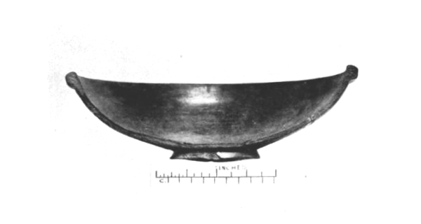
After P. H. G. Powell-Cotton and G. F. Pinfold, 1939, Plate IV.

Today’s image for Day 313 of the VM_365 shows half of a Roman pottery bowl found in one of the pits excavated and recorded by James Beck and Antoinette Powell-Cotton at Minnis Bay, Birchington in 1938.

The bowl, described as a half of a red ware colour coated dish, was found in the same pit as the double handled wine jug featured in yesterday’s post for Day 312 of the VM_365 project. Half of a 4th century black pottery vessel, fragments of millstones and part of an upper quern stone were also found in the pit.

VM_365 Day 312 Roman pottery from pits on foreshore at Minnis Bay

VM 312
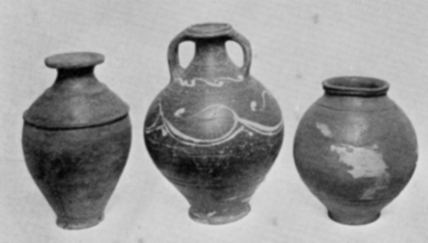
After P. H. G. Powell-Cotton and G. F. Pinfold, 1939, Plate III.

Today’s image for Day 312 of the VM_365 project shows three Roman pottery vessels found and excavated by James Beck and Antoinette Powell-Cotton in pits on the foreshore of Minnis Bay, Birchington in 1938.

The vessel on the left hand side of the image was found in a square shaped pit and is described as a ‘grey Belgic vase’ by Major Powell-Cotton and G. F. Pinfold in their report and catalogue of the site in 1939. This late Iron Age/Early Roman vessel was found along with the base of a 1st century rough cast pottery beaker and a fragment of Quern stone.

The vessel shown in the centre of the picture is described  as a two handled wine jar of New Forest type.  A wide range of wheel thrown fine wares were produced in the New Forest  in the 3rd and 4th century,  sometimes decorated as is the case with this vessel, and are generally found distributed across southern Britain. The vessel was found complete, in a pit along with some other pottery and a fragment of the upper part of a quernstone.

The vessel on the right was found in a pit beneath the millstone that featured in yesterday’s, Day 311 post for VM_365. The vessel was described as a fine red ware pot with the remains of decoration with white slip.

Some of the pits may be the remains of the bottoms of well as three contained springs. The pottery found in the pits dates from the early 1st century to the 3rd or 4th century indicating that this area had been a focus of activity by the Romans for at least 300 years.

VM_ 365 Day 311 Roman millstone from a pit at Minnis Bay.

VM 311
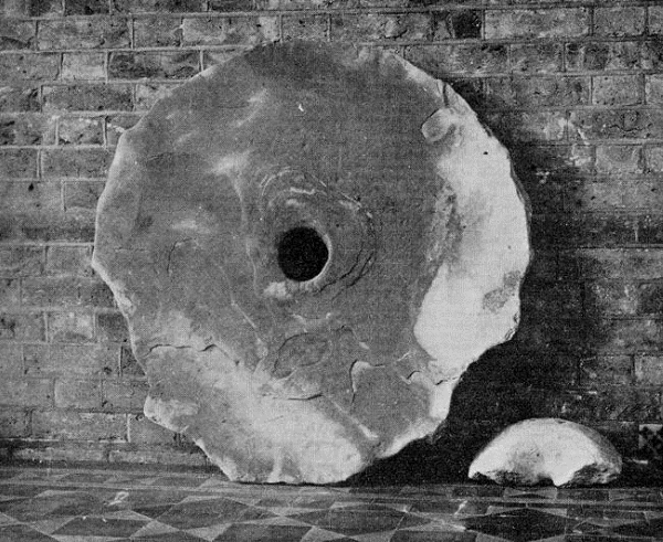
After P.H.G Powell-Cotton and G. F. Pinfold, 1939.

Today’s image for Day 311 of the VM_365 project shows a large Roman Millstone found on the foreshore at Minnis Bay in 1938 by a 14 year old schoolboy named James Beck. The picture of the millstone was taken at the Powell-Cotton Museum where the millstone now resides.

James Beck identified and excavated a group of eight pits of Roman date assisted by Antoinette Powell-Cotton. The millstone, measuring nearly a metre in diameter and almost 12 centimetres thick, was found covering one of the pits, an irregular shaped cut which measured about 73 centimetres deep. A fragment of millstone of a similar date found at Broadstairs previously featured on Day 59 of the VM_365 project. Below the millstone, the pit also contained a fine red ware vessel, two fragments of samian pottery, horses teeth and fragments of wood.

James Beck also identified a Bronze Age site in the same area as the group of Roman pits and excavated and recorded a Bronze Age hoard that was previously featured on Day 202 of the VM_365 project.


VM_365 Day 293 What’s in the archive box?

VM 293

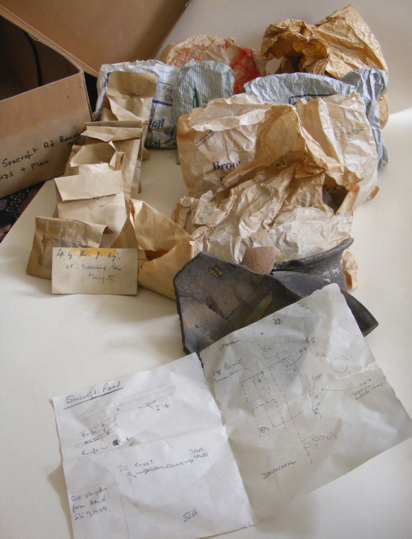
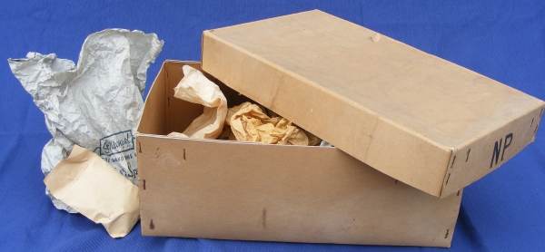
The Image for Day 293 of the VM_365 project is of the contents of the small cardboard archive box we started to look at in the post for Day 292. Although we have an idea from the label of the general area where the material may come from, a site at Dumpton Down between Broadstairs and Ramsgate, there is no record of what is actually in the box.

Our first task is to see what sort of material the archive contains, and what condition it is in. Then we need to know what sort of information it might be able to give us. In fact, even at first examination the box contains some very useful material. At least the box doesn’t contain bags of unwashed pottery or dried up leather.  The artefacts, which generally seem to be  pottery sherds of small to large size, seems to have been processed well.

Among the  containers stored in the box amount to eight paper bags from shops, which in themselves amount to something of a historic archive. There are also eight small brown paper envelopes, of a type people would have received cash wages in. Another similar wage packet envelope as a clear window in the front. There is one standard small brown envelope and a quantity of loose pottery sherds, some glued together to reconstruct part profiles. A small card in the box has the address of the excavator, Mr. Joe Coy,  from the  1960’s or 70’s written on it.

Best of all, there is a small paper sketch plan of an excavation, possibly where the artefacts came from. It’s not a perfect plan but it will help to evaluate what the finds in the bags can tell us. Each bag seems to have a feature code written on it, which may correspond with the plan and most of the sherds are marked with a site and feature code.

Although perhaps the containers leave something to be desired in archive stability, polythene mini-grip bags are probably preferable to a paper bag from a butcher’s shop in Margate, they have retained their contents reasonably well in the half century since the excavation was carried out.

In our next post for VM_365 Day 294 we will take a look at what is actually in some of the bags and what we might learn from the finds.

VM_365 Day 292 Unseen archives hold untold stories

VM 292

Today’s image for VM_365 Day 292 is of an unknown quantity, an archive of archaeological finds and records that has not been examined for decades. The long archive box above has a label that identifies it as being from an excavation carried out in 1964 by one of Thanet’s pioneering archaeologists Joe Coy, leader of the Thanet Excavation Group in the late 1960’s and 1970’s.

All over Britain there are similar collections of unexamined material that may hold all kinds of useful and informative material. What could we learn if each one of these collections could be opened and assessed? Digs that are decades old may have useful material to help with the interpretation of old sites and more recent excavations.

To begin with, the label on the box at least gives the artefacts in it a  location, a site near Dumpton Gap, on the east facing downland between Ramsgate and Broadstairs facing the sea to the east. Many excavations have been carried out in the area, over decades and by different groups and excavators.

The archaeological data we have for the area is widely distributed, and is in many respects rich and complex, but rather than a blanket of information we have something more like a moth eaten sheet, full of holes and missing pieces because of the tragic effects of time and entropy on the records and archives. After long years of travel and storage this small archive has finally ended up in the Trust’s collection. It has become our responsibility to  understand and preserve the material in the archive and pass it on as fully as we can.

This post for VM_365 will be the first of series that follows our exploration of what is almost an archaeological excavation in itself. We will begin to unpick the layers of material contained in the box and try to understand the value of each deposit and artefact that we discover.

VM_365 Day 266 The barrow reconstruction drawings get more complicated

VM 266

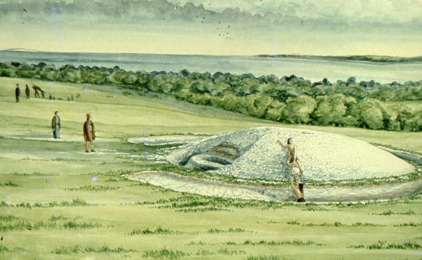
The image for Day 266 of the VM_365 project is the second in a series of images drawn by Dave Perkins, reconstructing the sequence of event associated with a funerary monument that was revealed in excavations at Lord of the Manor, Ramsgate.

In today’s image, the single ring ditch and mound that was shown in yesterday’s picture is being renewed, ready to receive another burial. The original ring ditch and its mound, now compressed and discoloured, have been sealed under fresh chalk which is being dug from a new ring ditch with a greater diameter than the earlier one. The circuit of the new ditch is  interrupted by a causeway, where a stretch of the circuit was not excavated. It is a process like this that created the concentric circuits of ditches that show up so well in the cropmark posted on VM_365 Day 264.

The location of the barrow is closely based on the landscape of the Lord of The Manor site, with the land falling away into a deep dry valley, which is shown covered with woodland. The sweep of the valley leads to the sea at Pegwell Bay in the upper right hand side of the picture. On the left side of the image a funeral procession is making its way up the side of the valley toward the newly refurbished barrow.

It is still possible in the present day to stand near the site of the barrow and see the same view over the bay which would have been presented to the prehistoric people of the area.  It was this experience of the landscape that Dave Perkins used to draw his reconstruction images.

Further analysis of the landscape has shown that there are only a few sites in Thanet’s landscape where such an uninterrupted view is possible and it becomes clear from considering the landscape that sites were carefully chosen to provide such a panoramic view. Excavations have shown that some were used over many thousands of years to locate settlements, gather for ceremonies and to create structures where the dead could be buried.

Once again we can reconstruct the facts that are presented by the archaeological features on the ground, but can never really confirm the reasoning behind the choice of location which is so well captured in the drawing. Was it to assert a power or domination over the landscape or to enhance the visibility of the monument from other sites? Motives may have changed over time passing from willful choice into tradition whose meanings were lost in the passage of time.

The true motives are lost without the record of contemporary voices, but we can explore possible meanings through attempts at reconstruction like the drawings in this series of posts. There are questions to ask about this reconstruction: was the natural environment so open and free of the influence of man as it is shown? Was it as simple a task to create a barrow as is suggested? The ring ditches of the many barrows that have now been excavated in Thanet have demonstrated that they are often perfectly circular with regular and symmetrical profiles throughout the circuit, despite the hard chalk rock that had to be cut to create them. It is immediately possible to suggest the picture could be made more accurate with the addition of some figures carrying out some quite complex surveying and architectural control over the cutting of the ditch as well as an indication of the greater amount of labour that went into cutting away the chalk in such quantity. Our ideas progress through such criticisms of the reconstruction, which perhaps leads in the future to new images that take new ideas on board. Sadly they will not have the benefit of Dave Perkins’ wisdom and experience to inform them.

VM_365 Day 265 Art inspired by the Lord of the Manor prehistoric archaeology

VM 265

The image for today’s post on Day 265 of the VM_365 project is an illustration by the Trust’s first Director David Perkins, inspired, as much of his work was,  by the landscape and prehistoric archaeology of Lord of the Manor Ramsgate.

The archaeological excavations that were carried out to explore the many features that were revealed by aerial photography in the area near Lord of the Manor were very significant to understanding the scale of prehistoric settlement in Thanet.

Using their experience of digging several of the major sites  revealed in the Landscape, both Dave Perkins and Len Jay used their artistic skills to record their activities and to interpret the sites they  were uncovering.

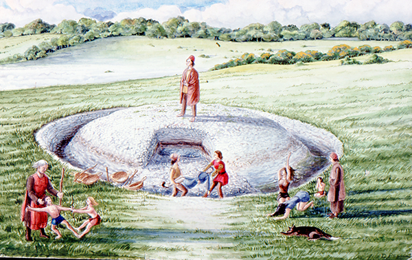
The coloured drawing  by Dave Perkins recreates a scene associated with the insertion of a new burial into the mound of one of the prehistoric round barrows located at the crest of the hill, an event that was attested in the archaeological record.

The stark white of the chalk that lies  at a shallow depth below the soil are visible in the cut of the ring ditch and the central mound where it was cast over a primary burial located at the centre. Baskets and shovels show that the ditch has been newly cleaned to refresh the surface of the chalk. The scene shows the mound as having been partly removed, so that another burial can be inserted within the circuit of the ditch. The later burial is perhaps that of a member of family who wishes to be close to a relative, or perhaps a clan member who wants to remind his followers of the source of his power. The burial may be of an unrelated individual who want to claim a connection with the glories of a bygone age. Grieving family members, along with warriors and perhaps elders of the clan are shown outside the ring ditch, while the person to be buried is carried across the ditch to the new grave.

Although the drawing reflects  the archaeological facts that were established from the sequence recovered from the ground, the truth of the scene’s representation of Bronze Age culture can never be known as there are no records to guide our interpretation with certainty.