Category Archives: Anglo Saxon

VM_365 Day 361 Curator’s Favourites: Producing cloth through the Ages.

VM 361As we have reached the final few days of our VM_365 posts we thought that it would be rather fun to introduce us to you as the Curators of VM_365 using either our favourite images or a summary of the posts that we contributed over the project. Our Curator today is me, Emma.

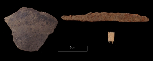
Today’s image for Day 361 features my favourite four images that we posted for the project. One of my hobbies outside of archaeology is sewing, particularly dressmaking (although do not ask me to take up your trousers or sew on a button which I loathe!). So, it would seem natural that my favourite four images are all implements dating from the Iron Age to the Anglo Saxon period that are associated with the production of cloth.

The manufacture of cloth is a process that is largely alien to most people whether they are interested in sewing or not. Cloth, be it natural or man made is delivered to us in bolts of pre woven fabric from which we can choose our fibre, weight and pattern preferences, we can buy it on the internet, by mail order and in shops. Personally manufacturing our own cloth is a practise long forgotten and these artefacts represent the processes involved when producing your own cloth was a necessity.

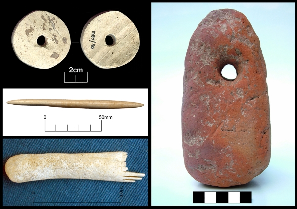
The artefact on the top left is a Roman spindle whorl which previously featured on Day 276 of the VM_365 project. This example was recycled from a sherd of 1st century flagon and would have been used to turn the raw product from fleece into yarn. The Spindle whorl was wedged onto a spindle which was suspended upright from the fibres to be turned into yarn. The spindle was set spinning and the twist travelled along the length of the fibres spinning it into yarn.

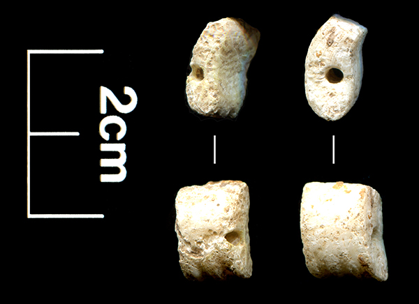
The artefact shown top right is an iron Age loom weight which previously featured on Day 115 of the VM_365 project. This example would have been used in a  simple warp weighted loom designed to stand against the wall. The loom weights would have been tied to the bottom of the warp (vertical) threads to add tension whilst the cloth was being woven.

The weaving comb shown in the bottom left of the image above is of late Iron Age date and would have been used to push threads into place during weaving. This example featured on Day 110 of the VM_365 project and it is unclear if it had actually been used as the decoration is unfinished and some of the tines are broken.

Pin beaters were used to beat down threads while using a warp weighted loom and the artefact shown middle left is a Middle Saxon bone double ended pin beater which previously featured on Day 144 of VM_365 project. The pin beater has been slightly flattened and polished smooth through frequent use. This artefact is my overall favourite, it is a simple object that has seen heavy use and would most likely have been a treasured tool worn over time to fit the hand of the person using it.


VM_365 Day 357 Dumpton Gap, Broadstairs historic landscape

VM 357

Today’s image for Day 357 is another one in the Our Thanet thread for VM_365. The overview of Dumpton Gap is taken from near the entrance to Seacroft Road, which is on the extreme left of the image. The view faces north across the bay where the deep valley meets the sea at the high chalk cliffs on the right side of the image.

Only as far back as the late 19th century this landscape was open downland, but at the beginning of the 20th century, the benevolent seaside landscape attracted several large convalescent homes, which were served by new roads that were laid out on the cliff top esplanade. A view similar to the one in today’s image was published in a 1907 sale catalogue for plots in the area, posted on Day 41 of the VM_365 project.

In the process of creating the framework of the dense suburb that now covers the valley, many significant archaeological discoveries were made. The earliest of these were recorded by Howard Hurd, one of Thanet’s heritage pioneers,  who as Borough Surveyor for Broadstairs and St. Peters laid out much of the road network which can be seen in the catalogue photograph.

On the slopes of the far side of the valley, on the horizon just left of the centre of the image is Valletta House, now Bradstow School, where Howard Hurd excavated and published a Bronze Age round Barrow and Anglo-Saxon cemetery. The site went on to be explored in several excavations as the gardens surrounding the house were developed over the next century revealing more Neolithic, Bronze Age and Iron Age features, as well as a further burial from the Anglo-Saxon cemetery.

On the far left side of the image, an extensive Iron Age settlement located on the southern side of the valley which later became the site of a Roman building,  was discovered by Howard Hurd in the early 20th century. A bone weaving comb from the site was published on Day 110 of the VM_365 project.

The site was explored further  in several excavations from the 1960’s to the 21st century when the development of suburban roads and closes with characteristic bungalows and semi-detached houses, were explored by Joe Coy, another important heritage pioneer. Pottery of Iron Age and Roman date from these excavations featured in several previous VM_365 posts.

The landscape shown in today’s post is perhaps one of the richest sources of archaeological information in Kent, but is little known in the wider archaeological community because of the limited circulation of the publications of the excavations and the lack of any recent attempt to bring all the sites together and reconsider their significance. Perhaps this overview for the VM_365 project will serve as a start in that process.

VM 365 Day 334 The landscape of Minnis Bay

VM 334

Today’s image for Day 334 of the VM_365 project shows a view of Minnis Bay, taken from the east, facing west toward Reculver. This view begins another short VM_365 series showing you our Thanet; the historic isle that we as archaeologists see around us.

Before the Bronze Age this landscape would have been significantly different. Sea levels were significantly lower than they are in the present day and much of the coastal area visible here would have been dry land.  A freshwater creek extended along the approximate route of Minnis Road, just out of the picture to the right. The flat greyish green area of the beach visible in the foreground are the remnant of chalk cliffs that once formed the edge of the valley the creek flowed through, which has been eroded to a flat platform by the sea pushing into the creek mouth in the later prehistoric period.

Many prehistoric finds including Palaeolithic and Neolithic worked flint have been found off this foreshore, the tools used by the people who once lived on the land that has been lost to the sea.  The remains of a Bronze Age settlement was discovered on the wave cut platform around the mouth of the creek in 1938. A Bronze Age hoard discovered in one of the pits has previously featured on Day 202 of the VM_365 project.

Beyond the wooden groynes that can be seen in the middle ground of the image is the former northern mouth of the Wantsum Channel, which became more significant as the sea advanced from the Bronze Age onward and separated what would become known as  the  Isle of Thanet from the mainland of Kent.

The sea continued to eat away at the land that was occupied by communities in later periods.  The bases of Late Iron Age and Roman pits and other features, possibly wells, have also been identified as truncated pits on the wavecut platform on the foreshore. Artefacts retrieved from these pits included a Roman millstone,  a two handled wine jar, and a colour coated dish.

Eroding pits and archaeological features of Late Iron Age and Roman date have been identified in the eroding cliff edges at Minnis Bay. On the horizon on the far right of the image is the site of a Roman fortress built on land at Reculver,  overlooking the mouth of the Wantsum Channel and the west coast of the Isle of Thanet.  The Fort and the settlement associated with it is beginning to be claimed by the sea. Coastal erosion has exposed the bases of Roman wells which are sometimes visible at low tide on the wave cut shelf at Reculver.

Reculver was also the site of one of the earliest and most important  Anglo Saxon monasteries. The former monastery and the church that now stands at Reculver were built on the site of the Roman Fort and elements of all these structures have been revealed in a long series of archaeological excavations.

The vantage point of the cliff top at Minnis Bay provides a view of thousands years of Thanet’s history which the archaeologist’s eye can distinguish from the natural landscape.

VM_365 Day 314 Mid Saxon pottery fabrics from Westgate

VM 314

The image for Day 314 of the VM_365 project is  of examples of pottery fabrics dating from the Mid Saxon period, spanning the mid 8th to the mid 9th century.

Pottery in Kent and elsewhere in this period was mostly handmade, with small bag-shaped vessels with everted rims most common. Some had their rims more neatly and evenly finished by turning the pot on a tournette, a stick or hand-turned wheel.

In East Kent two main fabric types were employed; sandy ware and shelly ware, the latter sometimes with some additional sand added.
Most of the the Mid Saxon sandy ware products were made at sites near Canterbury, beginning a nearly 900-year long period of continuous pottery manufacture in these workshops.

The two left hand rim fragments in the image are from cooking jars in Canterbury sandy ware fabrics. A small everted rim cup in a similar dark grey sandy ware fabric featured in the post for Day146 of the VM_365 project.

The larger rim at the right-hand end of the picture is from a larger vessel in shelly ware. The small plates of deliberately crushed shell are just visible on the surface of the sherd.

All of the sherds shown can be dated to a period between c.750-850 AD  which is currently rarely represented in Thanet’s archaeological record. The relative scarcity of pottery of this period is partly due to the fortunes of archaeological recovery. Few sites have been found in Thanet’s rural and coastal landscape and all the sherds shown as well as the cup in the earlier post were from a single site near Westgate. Much of the occupation in this period will have been masked by later medieval settlement and dwellings will have been mainly wooden structures which can be hard to detect. The rather low-fired pottery is vulnerable to damage from modern agricultural or building activity.

The information and images for this post were kindly provided by Nigel Macpherson Grant.

VM_365 Day 309 Artefacts from Anglo Saxon SFB at Woodchurch.

VM 309

Today’s image for Day 309 of the VM_365 project shows a selection of three artefacts which were found in the small segment excavated through the Anglo Saxon Sunken Featured Building from Woodchurch, Thanet that featured in yesterday’s VM_365 post for Day 308.

On the left hand side of the image is a sherd of Organic-tempered ware pottery of early to Mid Saxon date (c. 550/600 – 700 AD).

On the right hand side at the top of the image is an Iron Knife with a curved ‘hog-back’ blade, with a curved cutting edge that may be the result of repeated sharpening on a round section hone.

The small fragment of comb at the bottom of the image has been carved from bone and is from a one-piece double-sided comb. The spacing of the teeth is different on each side, suggesting that it had both a fine and coarse combing side.

VM_365 Day 308 Anglo Saxon SFB at Woodchurch, Thanet

VM 308

Today’s image for Day 308 of the VM_365 project shows a common type of archaeological feature of  Anglo Saxon date, known as a Sunken Featured Building, which was uncovered during an evaluation carried out in advance of the construction of a house at Woodchurch, Birchington in 2002. The picture is taken looking across the valley from Woodchurch toward the tree lined boundary of Quex Park. This is post is another example of a small keyhole investigation which has revealed important information without extensive excavation.

The depth of overburden above the chalk was less than 10 centimetres deep and so the entire footprint of the building was stripped to expose the chalk and reveal archaeological features. The Sunken Featured Building (usually shortened by archaeologists to the initials SFB) can just be made out in the centre foreground of the picture as a rectangular patch of earth slightly darker in colour than the periglacial brickearth stripe to the north and on which the photographic scales are placed.

Because it was possible to move the foundations of the house to avoid the SFB, only a small segment was excavated through it.  Artefacts recovered from the small area excavated included an Iron knife, a sherd of pottery and a small fragment from a double sided bone comb, which date the SFB from the mid to late 6th to 7th century.

Evidence of Anglo Saxon settlement is relativley rare in Thanet, compared to the known locations of cemeteries of this date. Other Sunken Featured Buildings have featured in previous VM_365 project posts, one from Margate on Day 83 and one from Sarre on Day 229.

The SFB at Woodchurch was abe to be preserved in situ and now survives below the lounge of the property.


VM_365 Day 279 Anglo Saxon Bronze Object

VM 279
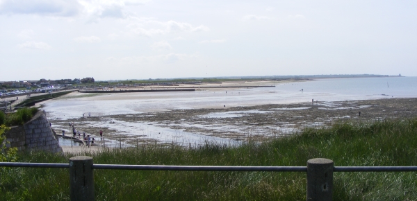
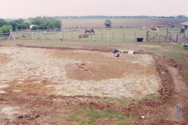
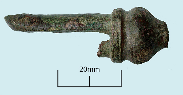
Today’s image for Day 279 of the VM_365 project is of a copper alloy object that was excavated during evaluations at Ebbsfleet, Thanet in 1990.

Made of copper alloy or bronze in a mould, the object has broken above the rounded tip and would originally have had two projections on the underside – one now broken. The surviving projection originally had a hole pierced through it, which would have been mirrored by the one on the other side. This hole has been filled by the remains of a bronze rivet which was used to fasten something between the two projections.

A similar object was excavated from grave 116 at the Anglo Saxon cemetery at Buckland, Dover. The Buckland object is more complete than our example and included a hanging loop at the top which connected to a bronze girdle hanger by a thick wire loop. Evison suggests that bronze rivets would have fastened the peg-like projections to a wooden shaft which could have been anything from a weaving implement to a holder for a hone stone.

Reference

Evison, V. I. 1987. Dover: Buckland Anglo Saxon Cemetery. HBMC Archaeological Report no. 3. pp 117, 242 & 320.

VM_365 Day 277 Anglo Saxon Bone awl

VM 277
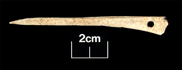
The image for Day 277 of the VM_365 project shows a bone awl found in a late 8th-9th century pit at Westgate during excavations in 2006.

At first glance this object is very similar to an Iron Age cloak pin that accompanied a burial in a pit at Dumpton. However, when you look closely at this artefact you can see that it has been carved from a much lighter weight bone from a large bird, possiby a duck, and the end has been purposely carved to a fine, sharp point rather than a rounded end as the cloak pin has been. The awl is also flat on either side rather than having a rounded profile.

So what would the awl have been used for? It would seem likely that this would have been made for piercing holes in hides or leather, perhaps for making shoes, bags and pouches. The flattened profile would allow the user more purchase when turning the awl to create a hole in a hide. The hole pierced through the end of  the awl was probably used to attach the awl to a belt or perhaps to allow it to be hung up so that it was easily to hand while working leather.

Another object used in the manufacture of cloth have also been found on the site, a beautifully carved and well used pin beater featured on Day 144 of the VM_365 project.

VM_365 Day 275 Amber beads

VM 275
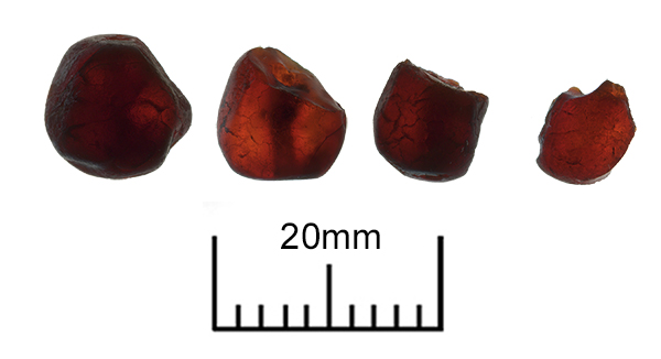
Today’s image for Day 275 of the VM_365 project shows four amber beads found in Grave 32 of the Monkton Anglo Saxon cemetery, part of which, was excavated in 1982.

The 6th century grave, was orientated east west and had been heavily truncated measuring only 0.14 metres deep. It contained only the fragmentary skeletal remains of the long bones of the leg and a single tooth to indicate the presence of the individual who had been buried there.

The beads are a mixture of roughly shaped pieces of amber that have been pierced through their length (far left) and carefully carved cylindrical shaped beads that have been broken on one end. The bead on the far right is a fragment that has broken through the centre. The holes through the centre of the beads can be seen on all four  if you look carefully.

Amber is fossilised tree resin and Anglo Saxon amber beads are assumed to have been imported from the shores of the Baltic where large deposits are well known. However deposits of amber are also known along the east coast of England and it cannot be assumed that all of the amber beads found in Anglo Saxon graves are from the Baltic shores; they may have been traded down the East Coast of Britain. It is not unknown for pieces of amber to be washed up on the beaches of Thanet.

VM_365 Day 269 Anglo Saxon Shell beads

VM 269

Today’s image for Day 269 of the VM_365 project shows two different views of the Anglo Saxon shell beads that were found in Grave 33 at the Monkton Anglo Saxon cemetery in 1982.

These two shell beads are most likely carved from Cowrie shell, the ribbing along their edges being the natural lip of the shell. These beads were probably imported along the same trade route from Byzantium as the amethyst beads found in the same grave and featured in yesterday’s VM_365 Day 268 post.

Cowrie shells have been found in other 7th century graves on Thanet  in Grave 238 at Sarre and Grave 323 at St Peters, Broadstairs. They have also been found in graves of a similar date at Wingham and Kingston, Kent. Those shells, however were whole and the suggestion is that they were treated as amulets. We do not know whether the beads found in the grave at Monkton arrived in Thanet as part of a whole shell and were carved locally or whether they were imported already crafted into beads.