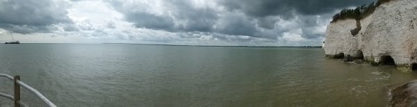
 Our image today for Day 335 of the VM_365 project is another for the Our Thanet series. This picture shows Pegwell Bay, viewed from the southern end of the Ramsgate harbour esplanade. The thin band of land on the horizon stretches from Deal pier at the western end, past Richborough and the mouth of the River Stour to the cliffs on the north east edge of the bay with their sea caves.
Once again the early prehistoric inhabitants of the area would not have recognised the bay as it is today. Evidence of their settlement has been found on the fringes of the present coast where it continues to be eroded by the force of the waves. On the land above the cliffs to the right of the image, two neolithic causewayed enclosures have been discovered and there are many sites of Bronze and Iron Age date in the landscape.
Rising sea levels created the bay and expanded the Stour, dividing Thanet from the mainland. The Iron Age people of Thanet first saw Roman traders and invaders arrive off this Bay and the forts and town at Richborough were dominant sites in the Roman period. Later the early settlers of the Anglo-Saxon period also sailed into this bay at Ebbsfleet and in 597 St Augustine’s Christian mission landed near Cliffsend, near the right side of the image.
The Stour’s present mouth was created to serve a port and supply bases created to serve the western front in World War 1 and in World War 2 the D-Day mulberry harbours set out from the Bay.
This view over Pegwell Bay encompasses thousands of years of significant events in both Thanet and Britain’s history.