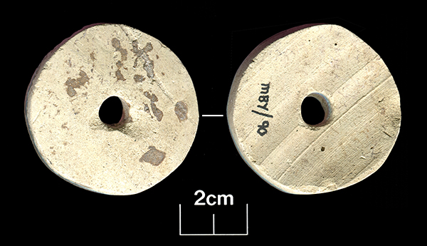
Today’s image for Day 276 of the VM_365 project shows two sides of a ceramic spindle whorl that was found during excavations at Minster, Thanet in 1990.
This Roman spindle whorl has been recycled from a sherd of a flagon dating to the second half of the 1st century A.D. The pottery sherd has been carefully shaped into a disc and a hole pierced through the centre. The disc is slightly curved, rather than flat, following the original profile of the flagon. In the picture on the left, marks left from turning the flagon on a potters wheel can clearly be seen as stripes in the fabric.
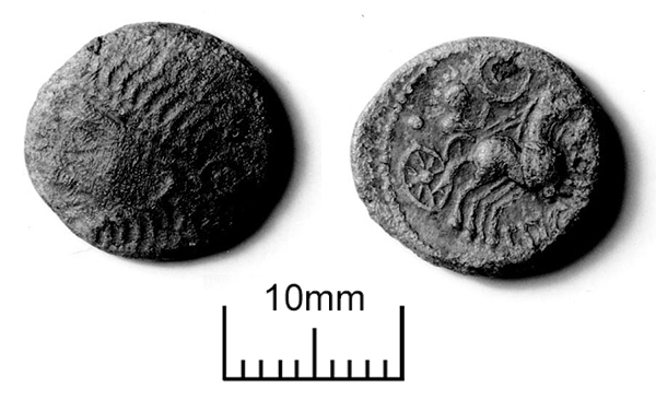
The image for Day 273 of the VM_365 project is of another coin dating to the Iron Age, a struck Bronze of a Late Iron Age King called Eppillus, which was found at Minster on the southern side of the Isle of Thanet .
The powerbase of the Atrebates was in the region around Chichester, which was known to them as Noviomagus. The Atrebates began a political relationship with the Roman Empire as its influence expanded on the continent. Coins of Eppillus issued from Noviomagus were marked Rex, indicating that the King’s power had been recognised by the Roman state.
Like many of the coins issued by Late Iron Age regional rulers in Kent, the example shown in the image today (Type: Van Arsdell 178) is based on a coin issued by Phillip of Macedon, the father of Alexander the Great. Although the images on the coins went through many incremental distortions and abstractions, the bust and chariot on either side of the coin can be traced through their evolutionary changes to their ancient Greek origins. The imagery reflects the independent connection of the Iron Age states with the classical Greek world.
Coins struck by the pre-Roman Kings of Kent provide material and written evidence that was independent of the control of the Roman state, although its influence on the iconography and texts can be detected in the years before the Empire expanded to Britain.
As our extended written evidence of pre-Roman Britain comes almost wholly from writers who lived in the dominant culture, the study of the Late Iron Age coin series allows us to perceive, however dimly, an alternative point of view to the Romans. The scatter of Iron Age coins, pottery and other artefacts from Minster in Thanet provide an indication of what came before the almost overwhelming amount of cultural information about the Roman period which is represented by sites like the Villa that was discovered in Minster.
Segment excavated through Bronze Age Barrow at Westgate in 2011. Scale shows 0.5m increments.
Today’s image for Day 271 of the VM_365 project shows a segment excavated through a well preserved ring ditch surrounding an Early Bronze Age barrow during an archaeological evaluation carried out at Westgate in 2011. The location of the barrow ditch, with a diameter of approximatley 27 metres, had been identified by aerial photography.
The evaluation established that the well preserved profile of the ditch was cut into the chalk geology to a depth of 1.4 metres from the base to the interface with the subsoil. Although the section shown in the image is cut slightly obliquely across the width of the ditch it gives a good impression of its large dimensions. At its widest point across the top the ditch measured 2.3 metres; the flat base was 1.3 metres wide.
A mound would have been built from the soil and chalk taken out of the ditch to cover a burial in a grave at the centre of the barrow. The ditch profile near the flat base was very steep sided, but the angle of the upper edges of the cut sloped more gently, creating an angled shoulder on the inner edge of the ring ditch. The limits of the shoulder allow us to estimate the diameter of the mound as a maximum of 22 metres and its possible original height as around 10-11 metres, assuming that the sides had as much as a 45 degree slope when it was originally built. Soil compression and slipping of the edges would have quickly reduced the height and angle of the mound unless it had been carefully compacted or structured in some way.
As the grave of a significant individual in the Early Bronze Age, we assume that the ditch was kept clear and that the mound was maintained to some degree, preserving its height and function as a monumental marker in the landscape. When it was abandoned the chalky covering of the mound began to erode into the ditch, filling the base with clean chalky material. Later more silty deposits accumulated in the hollow left by the ditch, derived from the soil that formed over the mound and the surrounding landscape.
It is often assumed that the decaying mound and ditch would have been a significant feature in the landscape, attracting later communities to reuse it for burisls and as a significant feature in the landscape. It is not often that the survival of a barrow mound or ditch can be dated. However the silty deposits that made up the upper fills of this barrow ditch contained abundant fragments of pottery, dating from as early as the middle Iron Age to the Roman period, in the 3rd century AD. This dateable material indicates that the hollow of the ditch remained a prominent feature, accumulating debris from nearby settlements many centuries after its builders and their successors had stopped looking after the monument.
How visible this feature was in the later Roman, Saxon and medieval periods we will never know as the most significant erosion suffered by the ring ditch and mound probabaly resulted from agricultural activity in the early 20th century and the eventual levelling of the site for recreational use.
Today’s image for Day 264 of the VM_365 project shows an aerial photograph of one of the most impressive groups of crop mark groups in Thanet’s historic landscape. The picture was taken in the the late 1970’s, from an aeroplane flying over the downland ridge at Lord of the Manor, Ramsgate overlooking Pegwell Bay.
In the photograph, which is facing south east toward Ramsgate, a chalk ridge extends from the lower right corner of the picture toward the top left. The ridge is isolated by the dry valleys that flank it on the right and left hand sides, affording spectacular views over the coastline to the south .
The overflight to photograph the cropmarks took place before several major developments in the road network in the immediate area took place, preserving a record of the landscape despite the considerable changes that have happened in recent years. The linear markings and circular shapes that can be seen through the variations in the colour of the crops growing in the field, indicate the locations of buried archaeological features and sites, which have been investigated in many phases of archaeological investigations that were guided by the location of the crop marks since the photograph was taken. The effect of buried archaeological sites which produced the variations in colour in the growing crop was explained in a drawing produced by Dave Perkins in our VM_365 post for Day 252.
The image for Day 261 of the VM_365 project shows two aspects of the archaeology of Drapers Mills, Margate, both from very different periods but occupying the same landscape.
In the foreground of the image the excavation of a Late Iron Age or Early Roman enclosure is taking place on the playing field of a school. The ditched enclosure is located on the periphery of the site of a Romano-British villa, which was disturbed by the construction of the school in the 1930’s and investigated by excavations between 1959 and 1961 and again in 1981. The villa probably replaced a small Iron Age settlement, which lay within the enclosure ditch. A filled in chalk quarry from the Roman period in the 2nd century AD, located near the houses to the right of the mill in the image, produced the cast bronze head of a boxer which appeared in the image for Day 17 of the VM_365 project. A wooden box storing a collection of the samian pottery from the villa excavations of 1959 to 1961 in the same area featured in VM_365 Day 86.
In the background at the centre of the image is Draper’s Mill, a smock mill constructed in 1845 by the Canterbury millwright John Holman. A smock mill has a sloping body, with a cap at the top that rotates so that the sails can be turned to face the wind. The windmill is the last survivor of three mid 19th century windmills that that once stood together on this rounded downland hilltop. Draper’s Mill was threatened with demolition in 1965, but was saved and restored in 1968.
Early maps show windmills occupying the hilltop near Drapers Mill as early as the 17th century, and it is likely that there were earlier post mills near the site in the medieval period, standing on similar trestle platforms and possibly within circular enclosures, to those at St. Peters and Sarre that were shown on VM_365 Day 259 and Day 260. The hilltop site overlooking the bay at Margate has been occupied for many thousands of years and its history is written in the archaeological record, both above and below ground.
This bowl copies the form of a samian bowl of Dragendorf 44 type. Samian pottery was generally manufactured on the continent in Gaul but like the bottle in the grave, the bowl was actually manufactured on the North Kent Marshes in pinkish red Hoo St Werburgh fabric. This vessel was difficult to date precisely although it must fall in the time bracket of AD.150-250/300; later than the introduction of the form in samian ware and earlier than the end of the Hoo pottery industry.
The bowl has a chipped flange and there is knife scoring over the interior surface, suggesting that it had been used before being deposited in the grave.
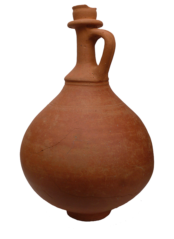
This bottle is classified as Pollard type 169 and has been manufactured in pinkish-brown Hoo St Werburgh fabric. It has a chipped rim, which may have been caused by the flint which was used as a stopper. The vessel dates between c.AD.150-250/300.
The beaker is in a colour coated ware, which means that the light coloured fabric of the pottery has been totally covered with a slip of dark glaze. The exterior of the pot was decorated further buy adding a white painted lattice pattern. The beaker was possibly manufactured in Gaul, in 3rd or 4th century AD.
Perhaps a story of greater human interest represented by this vessel are the impressions of the fingers of someone who grasped the body of the vessel before the clay had dried and left a lasting memorial of their otherwise unrecorded existence.
The survival of the intact vessels on the small archaeological site, despite the demolition of the buildings above and the use of a large toothed mechanical excavator bucket to grub out the foundations of the building that stood above it, is a matter of incredible luck.
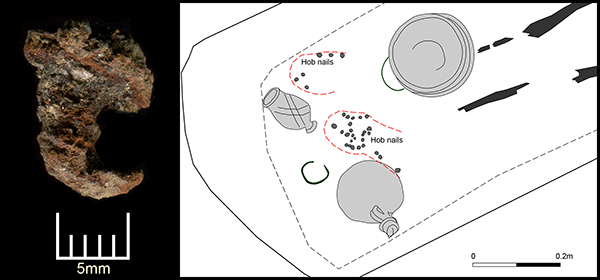
Today’s image for Day 255 of the VM_365 project follows on from yesterday’s journal post about the late 3rd to early 4th century burial at Ramsgate. It shows one of the best preserved of the 29 hobnails excavated from the grave along with a location plan of where they were found.
It is not clear if all the hobnails survived and, as the grave had been heavily disturbed by plant roots, it was not possible to determine the exact pattern of hobnails. Two groups of hobnails were identified presumably representing two seperate shoes which may have been worn by the young adult female when she was buried.
Hobnails were used to prolong the life of footwear which was usually made entirely of leather and to give them a better grip on the floor surface.
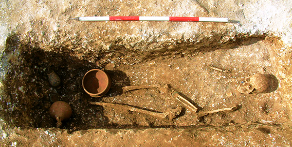
Today’s image for Day 254 of the VM_365 project shows a late 3rd to early 4th century Roman grave, excavated in Ramsgate in 2007.
The grave was orientated north east to south west and had been heavily truncated in the past from later activity on the site. The grave cut measured only 0.3 metres deep when it was excavated.
The skeletal remains were of a young adult female, laid on her back with her legs extended and the left arm slightly flexed with the wrist resting on the pelvis. The bones of her right arm were very fragmentary and their exact position could not be determined. The general condition of the skeleton was poor as no hand, ribs, spine or foot bones survived and most ends of the long bones were missing.
The woman had been buried wearing a twisted copper alloy wire bracelet on her left wrist and she may also have been wearing shoes as twenty nine hobnails were recovered from the end of the grave in the approximate location of her feet.
Ten iron nails found around the edge of the grave suggest that a wooden board had been placed over her body. The body was accompanied by three pottery accessory vessels – a bowl, a bottle and a beaker placed at the end of the grave on top of the board, along with a second copper alloy bracelet and a loop of wire which may have fastened a fabric pouch.
The bowl was located over the right lower leg, the loop of narrow copper alloy wire with two twists or knots which may have fastened a fabric pouch was found under the rim. The beaker had been placed on the north western side of the grave and the bottle, apparently sealed with a stopper made from a natural flint nodule, had been place on the south eastern side. The copper alloy bracelet lay between the bottle and beaker.
This burial is very significant as it complements the antiquarian records of similar discoveries in the immediate area which were published by Robert Hicks in the 19th century.
 The image for Day 273 of the VM_365 project is of another coin dating to the Iron Age, a struck Bronze of a Late Iron Age King called Eppillus, which was found at Minster on the southern side of the Isle of Thanet .
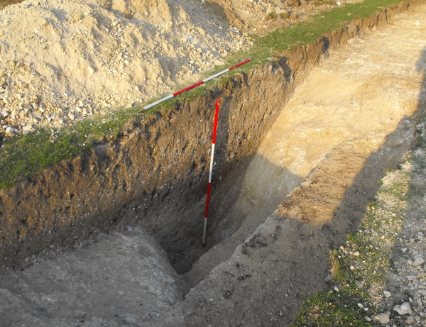
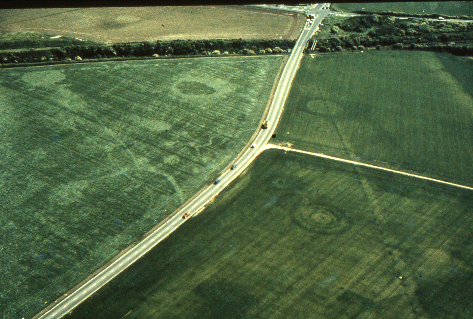 Today’s image for Day 264 of the VM_365 project shows an aerial photograph of one of the most impressive groups of crop mark groups in Thanet’s historic landscape. The picture was taken in the the late 1970’s, from an aeroplane flying over the downland ridge at Lord of the Manor, Ramsgate overlooking Pegwell Bay.
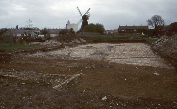 The image for Day 261 of the VM_365 project shows two aspects of the archaeology of Drapers Mills, Margate, both from very different periods but occupying the same landscape.
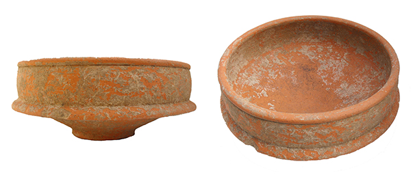
 The image for Day 256 0f the VM_365 project is of a Roman Beaker found in a grave excavated in Ramsgate, which has