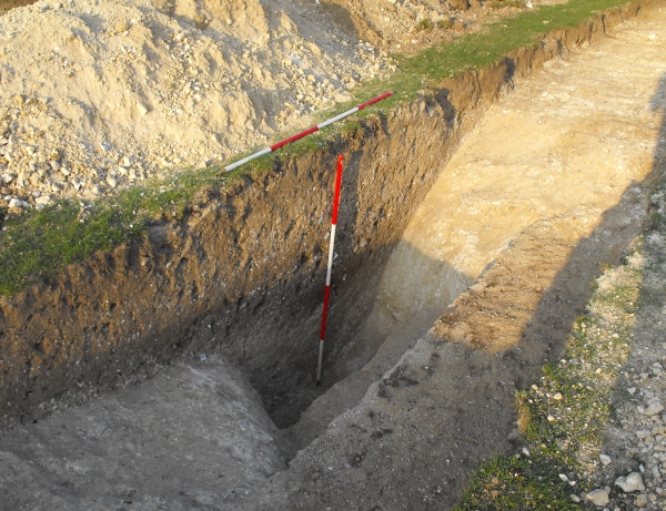
Today’s image for Day 271 of the VM_365 project shows a segment excavated through a well preserved ring ditch surrounding an Early Bronze Age barrow during an archaeological evaluation carried out at Westgate in 2011. The location of the barrow ditch, with a diameter of approximatley 27 metres, had been identified by aerial photography.
The evaluation established that the well preserved profile of the ditch was cut into the chalk geology to a depth of 1.4 metres from the base to the interface with the subsoil. Although the section shown in the image is cut slightly obliquely across the width of the ditch it gives a good impression of its large dimensions. At its widest point across the top the ditch measured 2.3 metres; the flat base was 1.3 metres wide.
A mound would have been built from the soil and chalk taken out of the ditch to cover a burial in a grave at the centre of the barrow. The ditch profile near the flat base was very steep sided, but the angle of the upper edges of the cut sloped more gently, creating an angled shoulder on the inner edge of the ring ditch. The limits of the shoulder allow us to estimate the diameter of the mound as a maximum of 22 metres and its possible original height as around 10-11 metres, assuming that the sides had as much as a 45 degree slope when it was originally built. Soil compression and slipping of the edges would have quickly reduced the height and angle of the mound unless it had been carefully compacted or structured in some way.
As the grave of a significant individual in the Early Bronze Age, we assume that the ditch was kept clear and that the mound was maintained to some degree, preserving its height and function as a monumental marker in the landscape. When it was abandoned the chalky covering of the mound began to erode into the ditch, filling the base with clean chalky material. Later more silty deposits accumulated in the hollow left by the ditch, derived from the soil that formed over the mound and the surrounding landscape.
It is often assumed that the decaying mound and ditch would have been a significant feature in the landscape, attracting later communities to reuse it for burisls and as a significant feature in the landscape. It is not often that the survival of a barrow mound or ditch can be dated. However the silty deposits that made up the upper fills of this barrow ditch contained abundant fragments of pottery, dating from as early as the middle Iron Age to the Roman period, in the 3rd century AD. This dateable material indicates that the hollow of the ditch remained a prominent feature, accumulating debris from nearby settlements many centuries after its builders and their successors had stopped looking after the monument.
How visible this feature was in the later Roman, Saxon and medieval periods we will never know as the most significant erosion suffered by the ring ditch and mound probabaly resulted from agricultural activity in the early 20th century and the eventual levelling of the site for recreational use.