Category Archives: Thanet archaeology

News items about Thanet archaeology

VM_365 Day 294 Iron Age and Roman pottery sherds from 1964 Dumpton excavation Archive

VM 294

The image for today’s post on Day 294 of the VM_365 project shows the contents of some of the paper bags, stored in an archive box from an excavation carried out by Joe Coy with the Thanet Excavation Group at Dumpton, between Broadstairs and Ramsgate in 1964.

To understand how important the information contained in the archive is, we need to carefully examine how and why each item has been stored and labelled. In the image above the sherds are laid out on the paper shop bags they were stored in so that they can be assessed in more detail. Later they will need to be catalogued and put into plastic bags which will help to ensure their safe storage in the long term

All but two of the bags in the 1964 excavation box contain pottery sherds. The sherds have generally been marked with a site code and feature number, which we now know corresponds with feature numbers on the sketch plan in the box.

There seems to be no corresponding finds list, description of the pottery or dating for the items in the archive box, so each pottery sherd  may have to be re-examined to understand the date range of the features fully.

However even a casual examination of the material reveals the span of the dates covered by the sherds, apparently a classic assemblage spanning the Late Iron Age and Early Roman period. Many of the pottery sherds are comparable with typical vessel types from other sites the local area, which have featured in earlier VM_365 posts.

The site excavated by Joe Coy and the Thanet Excavation Group in 1964 is very close to a large site excavated at Dumpton Gap by Howard Hurd, one of Thanet’s archaeological pioneers. Although Hurd emphasised the Iron Age aspects of his site, described by him as the remains of ‘a Late Celtic Village’, later excavations suggested that there was a more significant Roman element to the settlement than was previously thought. As we start to understand the 1964 archive, it looks likely that this will make a significant contribution to understanding that Roman settlement phase here.

The analysis will continue in subsequent posts.
VM_365 Day 292 Unseen archives hold untold stories

VM 292

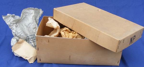
Today’s image for VM_365 Day 292 is of an unknown quantity, an archive of archaeological finds and records that has not been examined for decades. The long archive box above has a label that identifies it as being from an excavation carried out in 1964 by one of Thanet’s pioneering archaeologists Joe Coy, leader of the Thanet Excavation Group in the late 1960’s and 1970’s.

All over Britain there are similar collections of unexamined material that may hold all kinds of useful and informative material. What could we learn if each one of these collections could be opened and assessed? Digs that are decades old may have useful material to help with the interpretation of old sites and more recent excavations.

To begin with, the label on the box at least gives the artefacts in it a  location, a site near Dumpton Gap, on the east facing downland between Ramsgate and Broadstairs facing the sea to the east. Many excavations have been carried out in the area, over decades and by different groups and excavators.

The archaeological data we have for the area is widely distributed, and is in many respects rich and complex, but rather than a blanket of information we have something more like a moth eaten sheet, full of holes and missing pieces because of the tragic effects of time and entropy on the records and archives. After long years of travel and storage this small archive has finally ended up in the Trust’s collection. It has become our responsibility to  understand and preserve the material in the archive and pass it on as fully as we can.

This post for VM_365 will be the first of series that follows our exploration of what is almost an archaeological excavation in itself. We will begin to unpick the layers of material contained in the box and try to understand the value of each deposit and artefact that we discover.

VM_365 Day 283 The North Foreland landscape

VM 283

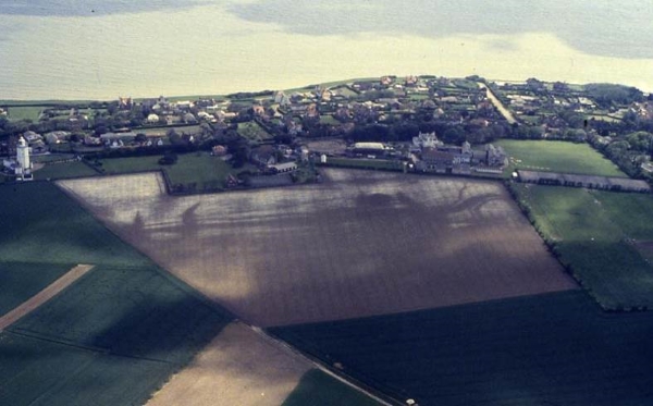
Today’s image for Day 283 of the VM_365 project shows a complex group of cropmarks of linear and curvilinear features, stretching along the western side of the valley at North Foreland, Broadstairs. The aerial photograph were taken by the Trust in 1990 and the image faces east, looking out toward the sea. On the left hand side of the picture you can see North Foreland Lighthouse; along the sea edge is the private North Foreland estate.

Running along the west facing valley side,  the cropmark has at least six parallel linear ditches.  At the southern end of the cropmark (right of picture) several of the features take a sharp bend to the east before curving back to the same north south orientation.

The cropmarks on the chalk ridge at North Foreland have been interpreted as a multi ditched promontory fort of the Iron Age but the projection of the aerial photographic plots of the ditches on to a topographic model clearly shows them falling downhill toward the valley bottom rather than following a contour around the promontory. Recent excavations and analysis suggest that the cropmarks represent the multiple ditches of an ancient trackway, dating back at least to the Iron Age.

Excavation of sample sections through the cropmarks by the Isle of Thanet Archaeological Society in 1994 suggested that although the linear ditches originated in the Iron Age, they were recut several times and material continued to be deposited in them until the 3rd century AD (Hogwood 1995). One of the ditches on the crest of the hill was sampled and dated to the late Iron Age during excavations in 1999 and 2003 by the Trust or Thanet Archaeology. This major route seems to have extended from the coast near Kingsgate and rose through the valley to reach the ridge of Thanet’s chalk plateau, from where it led all the way to Sarre on the western side of the Island.


VM_365 Day 274 Iron Age coin Links North Foreland with continental intrigue

VM 274

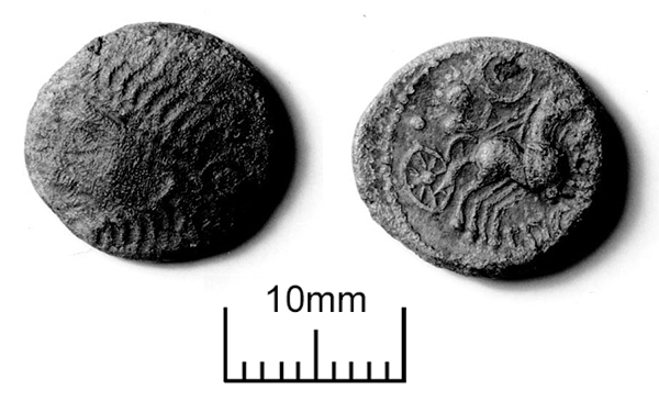
The image today for Day 274 of the VM_365 project is of an Iron Age coin (a Van Arsdell Type 194), issued by Amminus, who was possibly also known as Adminius. Becoming King of the Kent’s Cantiaci tribe in the early to middle of the 1st century A.D., Amminus was thought to have had strong pro-Roman sympathies. Amminus was a son of Cunobeline, a King of the Catuvellauni in the early part of the 1st century. A gold stater minted by Cunobeline and found at St Nicholas at Wade featured in the VM_365 post for Day 272.

The coin in today’s image was found at North Foreland, on the eastern tip of the Isle of Thanet, where a large Iron Age settlement dating from the mid to Late Pre-Roman Iron Age occupied the crest of a chalk ridge overlooking the sea and an important shipping route to the mouth of the Thames estuary.

The coin links the location and its contemporary archaeology to the murky intrigue that eventually culminated in the full scale invasion of Britain by the Roman Empire. The limited contemporary evidence that is available from the distribution of coins of Amminus/Adminus is supplemented by a text reference in the biography of the Emperor Caligula produced by Roman historian Suetonius.

Seutonius claimed that Caligula had exaggerated the banishment of Amminus/Adminius and a group of followers for unknown reasons, into a grand announcement in the Senate  that the Emperor had secured victory over the whole Island of Britain.  Amminus may have also played a part in Caligula’s military posturing, which culminated in an abortive invasion of Britain. It has also been suggested that Amminus returned to Britain with the Emperor Claudius as an advisor and possible later as a Governor.

The coin issued by Amminus links the archaeology of the North Foreland, one of the major coastal Iron Age settlements in Kent, to the power struggles between the British tribal leaders and the growing Roman Empire which must have played a part in the defence of the Island against the Roman invasion fleet.


VM_365 Day 273 Coins and Iron Age Minster

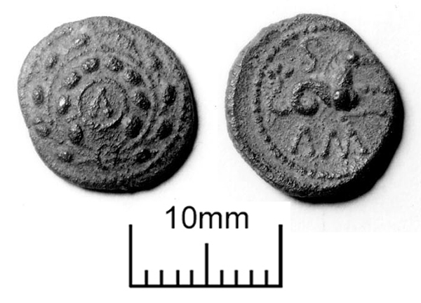
VM 273The image for Day 273 of the VM_365 project is of another coin dating to the Iron Age, a struck Bronze of a Late Iron Age King called Eppillus, which was found at Minster on the southern side of the Isle of Thanet .
The biography of Eppillus is largely based on the evidence, using the tiny scraps of written evidence derived from the inscriptions on coins. Eppillus became king of the Cantiaci, the tribe that lived in Kent, around 15 A.D. , possibly after he was deposed or replaced as King of the Atrebates by his brother Verica.

The powerbase of the  Atrebates was in the region around Chichester, which was known to them as Noviomagus. The Atrebates began a political relationship with the Roman Empire as its influence expanded on the continent. Coins of Eppillus issued from Noviomagus were marked Rex, indicating that the King’s power had been recognised by the Roman state.

Like many of the coins issued by Late Iron Age regional rulers in Kent, the example shown in the image today (Type: Van Arsdell 178) is based on a coin issued by Phillip of Macedon, the father of Alexander the Great. Although the images on the coins went through many incremental distortions and abstractions, the bust and chariot on either side of the coin can be traced through their evolutionary changes to their ancient Greek origins. The imagery reflects the independent connection of the Iron Age states with the classical Greek world.

Coins struck by the pre-Roman Kings of Kent provide material and written evidence that was independent of the control of the Roman state, although its influence on the iconography and texts can be detected in the years before the Empire expanded to Britain.

As our extended written evidence of pre-Roman Britain comes almost wholly from writers who lived in the dominant culture, the study of the Late Iron Age coin series allows us to perceive, however dimly, an alternative point of view to the Romans. The scatter of Iron Age coins, pottery and other artefacts from Minster in Thanet provide an indication of what came before the almost overwhelming amount of cultural information about the Roman period which is represented by sites like the Villa that was discovered in Minster.

VM_365 Day 266 The barrow reconstruction drawings get more complicated

VM 266

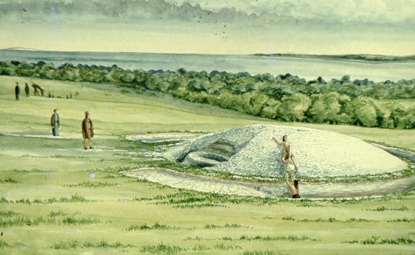
The image for Day 266 of the VM_365 project is the second in a series of images drawn by Dave Perkins, reconstructing the sequence of event associated with a funerary monument that was revealed in excavations at Lord of the Manor, Ramsgate.

In today’s image, the single ring ditch and mound that was shown in yesterday’s picture is being renewed, ready to receive another burial. The original ring ditch and its mound, now compressed and discoloured, have been sealed under fresh chalk which is being dug from a new ring ditch with a greater diameter than the earlier one. The circuit of the new ditch is  interrupted by a causeway, where a stretch of the circuit was not excavated. It is a process like this that created the concentric circuits of ditches that show up so well in the cropmark posted on VM_365 Day 264.

The location of the barrow is closely based on the landscape of the Lord of The Manor site, with the land falling away into a deep dry valley, which is shown covered with woodland. The sweep of the valley leads to the sea at Pegwell Bay in the upper right hand side of the picture. On the left side of the image a funeral procession is making its way up the side of the valley toward the newly refurbished barrow.

It is still possible in the present day to stand near the site of the barrow and see the same view over the bay which would have been presented to the prehistoric people of the area.  It was this experience of the landscape that Dave Perkins used to draw his reconstruction images.

Further analysis of the landscape has shown that there are only a few sites in Thanet’s landscape where such an uninterrupted view is possible and it becomes clear from considering the landscape that sites were carefully chosen to provide such a panoramic view. Excavations have shown that some were used over many thousands of years to locate settlements, gather for ceremonies and to create structures where the dead could be buried.

Once again we can reconstruct the facts that are presented by the archaeological features on the ground, but can never really confirm the reasoning behind the choice of location which is so well captured in the drawing. Was it to assert a power or domination over the landscape or to enhance the visibility of the monument from other sites? Motives may have changed over time passing from willful choice into tradition whose meanings were lost in the passage of time.

The true motives are lost without the record of contemporary voices, but we can explore possible meanings through attempts at reconstruction like the drawings in this series of posts. There are questions to ask about this reconstruction: was the natural environment so open and free of the influence of man as it is shown? Was it as simple a task to create a barrow as is suggested? The ring ditches of the many barrows that have now been excavated in Thanet have demonstrated that they are often perfectly circular with regular and symmetrical profiles throughout the circuit, despite the hard chalk rock that had to be cut to create them. It is immediately possible to suggest the picture could be made more accurate with the addition of some figures carrying out some quite complex surveying and architectural control over the cutting of the ditch as well as an indication of the greater amount of labour that went into cutting away the chalk in such quantity. Our ideas progress through such criticisms of the reconstruction, which perhaps leads in the future to new images that take new ideas on board. Sadly they will not have the benefit of Dave Perkins’ wisdom and experience to inform them.

VM_365 Day 265 Art inspired by the Lord of the Manor prehistoric archaeology

VM 265

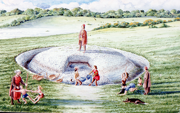
The image for today’s post on Day 265 of the VM_365 project is an illustration by the Trust’s first Director David Perkins, inspired, as much of his work was,  by the landscape and prehistoric archaeology of Lord of the Manor Ramsgate.

The archaeological excavations that were carried out to explore the many features that were revealed by aerial photography in the area near Lord of the Manor were very significant to understanding the scale of prehistoric settlement in Thanet.

Using their experience of digging several of the major sites  revealed in the Landscape, both Dave Perkins and Len Jay used their artistic skills to record their activities and to interpret the sites they  were uncovering.

The coloured drawing  by Dave Perkins recreates a scene associated with the insertion of a new burial into the mound of one of the prehistoric round barrows located at the crest of the hill, an event that was attested in the archaeological record.

The stark white of the chalk that lies  at a shallow depth below the soil are visible in the cut of the ring ditch and the central mound where it was cast over a primary burial located at the centre. Baskets and shovels show that the ditch has been newly cleaned to refresh the surface of the chalk. The scene shows the mound as having been partly removed, so that another burial can be inserted within the circuit of the ditch. The later burial is perhaps that of a member of family who wishes to be close to a relative, or perhaps a clan member who wants to remind his followers of the source of his power. The burial may be of an unrelated individual who want to claim a connection with the glories of a bygone age. Grieving family members, along with warriors and perhaps elders of the clan are shown outside the ring ditch, while the person to be buried is carried across the ditch to the new grave.

Although the drawing reflects  the archaeological facts that were established from the sequence recovered from the ground, the truth of the scene’s representation of Bronze Age culture can never be known as there are no records to guide our interpretation with certainty.

VM_365 Day 252 Crop and Soil Marks

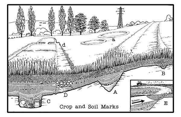
How Crop and Soil Marks are formed illustrated by D. R. J. Perkins.

Today’s image for Day 252 of the VM_365 project is an illustrations produced by Dave Perkins to explain how crop and soil marks, indicating the presence of buried archaeological deposits, form in the growing plants in Thanet’s agricultural fields. These cropmarks are usually identified by aerial photography.

Pits or ditches that have been cut into the bedrock retain moisture in dry spells and crops planted above them grow taller and darker (A) and (a). The intensity of the cropmark vary, shallow features give only faint marks (B) and deeply buried remains can produce nothing at all (C). Buried masonry,  where there is less moisture and soil for  the crop to grow, produces a negative mark, where the crop is shorter than the surrounding area (D).

Soil marks result when ploughing brings different coloured material from ancient deposits to the surface of a field (E).

Crop and soil marks have been a valuable resource for plotting archaeological sites over very large areas of agricultural landscape, particularly in the central agricultural areas of Thanet outside the main towns. The presence of mapped cropmarks has helped to predict what archaeological features may be found before excavations have taken place. However although they have been a good indication of the scale of buried sites, excavation has often revealed considerably more detail and complexity which was not present in the cropmarks.

VM_365 Day 247 More bath houses and buildings at Minster Roman Villa

VM 247

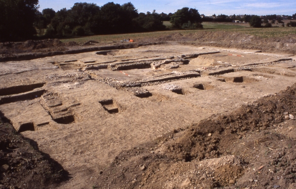
Day 247 of the VM_365 project is our penultimate post on the series of images of the main buildings of the Roman Villa at Minster in Thanet, a view facing north west across a building located at the south west corner of the villa complex.

The post for VM_365 Day 246 featured a two roomed corridor house, Building 4,  added to the south eastern corner of the boundary wall surrounding the main winged villa building.  The image today shows the foundations of a similar two chambered structure that had been added to the outside of the south west corner (Building 6).

The excavation of building 6 revealed a more complex story where at least three phases of structure were traced in the same area.  The original two roomed building that had been added to the south west corner of the boundary wall was similar in plan and construction to the core of Building 6. However, soon after it was built it was converted into a bath house through the addition of extra rooms and a furnace feeding a hypocaust. As the villa had a detached bathhouse within the western side of the walled compound, it is not clear whether the two bath houses were operated at the same time.

Small finds from the bath house excavation included copper alloy toilet sets for personal grooming and several of the bone pins that were found during the excavation were recovered form this area.

Later still the extra buildings of the bathhouse were removed and the furnace and hypocaust were backfilled with debris. The two chambered structure was restoredmon a new set of foundations.

Behind the building at the far end of the trench, a circular pit can be seen in the image. The pit was the upper cut of a deep well, sunk into the crest of the valley beyond, which may have supplied water to the bath house adapted from the two room building. The fills of the well contained large quantities of broken pottery and some more delicate finds such as the leaf shaped pendants shown in the post for VM_365 Day 31.

The complex  series of construction, conversion and replacement demonstrated how a major building like the Minster villa was frequently altered and adapted to suit the present needs of the two or three generations of people who may have occupied it, despite its relatively short life and eventual demolition in the Roman period.

VM_365 Day 241 Accessory vessel from burial at Thorne, discovered in Gas pipeline

VM 241

The image for Day 241 of the VM_365 project is of a pottery vessel placed with a skeleton in a Roman grave discovered on a gas pipeline project at Thorne, near Cliffsend. Vessels from a cremation group from the same area, discovered in the same pipeline project, were shown in the post for VM_365 Day 239.

The north south orientated grave contained the skeleton of an adult around 25 years old. The small pottery beaker or jar was found along with a flagon near the head of the individual.

The pot is made in a grog tempered fabric,  where fragments of crushed ceramic has been added to the clay paste. Occasional stone grits are also visible where they protrude from small faults in the surface. The outer surface of the pot has been lightly burnished.

The range of vessels that were recovered from this small cemetery illustrates the market for a wide range of styles of pottery and probably the diverse products that were shipped in the pots, which existed in Thanet in the Roman period. Each grave is  a snapshot of the pottery that lay to hand as the accessory vessels for a burial or cremation were assembled. The surviving vessels from grave groups, as well as those from remarkable survivals like the dump of Roman kitchenware discovered at Broadstairs, allow archaeologists to reconstruct the suites of pottery that were available to settlements in Thanet.