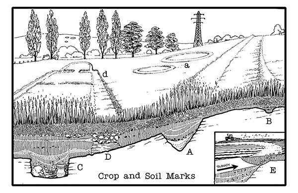
Today’s image for Day 252 of the VM_365 project is an illustrations produced by Dave Perkins to explain how crop and soil marks, indicating the presence of buried archaeological deposits, form in the growing plants in Thanet’s agricultural fields. These cropmarks are usually identified by aerial photography.
Pits or ditches that have been cut into the bedrock retain moisture in dry spells and crops planted above them grow taller and darker (A) and (a). The intensity of the cropmark vary, shallow features give only faint marks (B) and deeply buried remains can produce nothing at all (C). Buried masonry, where there is less moisture and soil for the crop to grow, produces a negative mark, where the crop is shorter than the surrounding area (D).
Soil marks result when ploughing brings different coloured material from ancient deposits to the surface of a field (E).
Crop and soil marks have been a valuable resource for plotting archaeological sites over very large areas of agricultural landscape, particularly in the central agricultural areas of Thanet outside the main towns. The presence of mapped cropmarks has helped to predict what archaeological features may be found before excavations have taken place. However although they have been a good indication of the scale of buried sites, excavation has often revealed considerably more detail and complexity which was not present in the cropmarks.
2 thoughts on “VM_365 Day 252 Crop and Soil Marks”