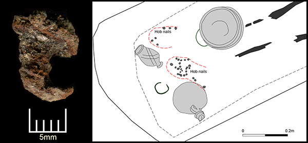
Today’s image for Day 255 of the VM_365 project follows on from yesterday’s journal post about the late 3rd to early 4th century burial at Ramsgate. It shows one of the best preserved of the 29 hobnails excavated from the grave along with a location plan of where they were found.
It is not clear if all the hobnails survived and, as the grave had been heavily disturbed by plant roots, it was not possible to determine the exact pattern of hobnails. Two groups of hobnails were identified presumably representing two seperate shoes which may have been worn by the young adult female when she was buried.
Hobnails were used to prolong the life of footwear which was usually made entirely of leather and to give them a better grip on the floor surface.
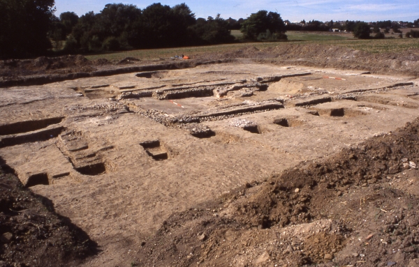
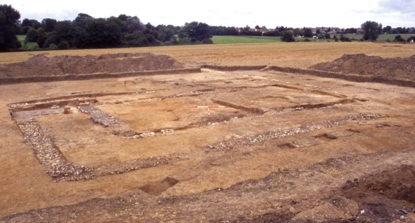
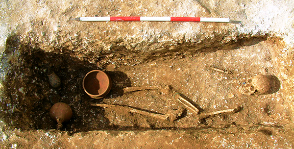
Today’s image for Day 254 of the VM_365 project shows a late 3rd to early 4th century Roman grave, excavated in Ramsgate in 2007.
The grave was orientated north east to south west and had been heavily truncated in the past from later activity on the site. The grave cut measured only 0.3 metres deep when it was excavated.
The skeletal remains were of a young adult female, laid on her back with her legs extended and the left arm slightly flexed with the wrist resting on the pelvis. The bones of her right arm were very fragmentary and their exact position could not be determined. The general condition of the skeleton was poor as no hand, ribs, spine or foot bones survived and most ends of the long bones were missing.
The woman had been buried wearing a twisted copper alloy wire bracelet on her left wrist and she may also have been wearing shoes as twenty nine hobnails were recovered from the end of the grave in the approximate location of her feet.
Ten iron nails found around the edge of the grave suggest that a wooden board had been placed over her body. The body was accompanied by three pottery accessory vessels – a bowl, a bottle and a beaker placed at the end of the grave on top of the board, along with a second copper alloy bracelet and a loop of wire which may have fastened a fabric pouch.
The bowl was located over the right lower leg, the loop of narrow copper alloy wire with two twists or knots which may have fastened a fabric pouch was found under the rim. The beaker had been placed on the north western side of the grave and the bottle, apparently sealed with a stopper made from a natural flint nodule, had been place on the south eastern side. The copper alloy bracelet lay between the bottle and beaker.
This burial is very significant as it complements the antiquarian records of similar discoveries in the immediate area which were published by Robert Hicks in the 19th century.
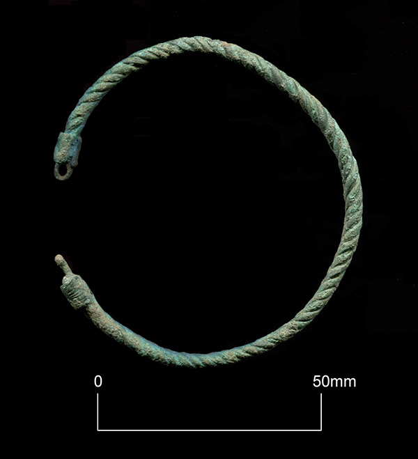
Today’s image for Day 253 of the VM_365 project shows a Roman copper alloy bracelet found within the 3rd to 4th century grave of a young adult female at Grange Road, Ramsgate in 2007. The complete pennanular bracelet is shown in situ in an image for Day 58 of VM_365.
The bracelet measures approximately 75mm in diameter and is made from four strands of wire twisted tightly together to form a single length. The diameter of the twisted wire measures approximately 4mm with each strand measuring 1mm. The ends of the bracelet fasten together in a hook and loop with the hooked end formed from a single strand of the wire reinforced with a flattened copper alloy strip clamped it to prevent unravelling. The looped end of the bracelet is formed in a similar way but with a single strand of wire bent over on itself and clamped with a strip of metal. The wire forming the looped end of the fastening had been beaten flat.
When it was originally deposited at the foot end of the grave, the bracelet would have been beautifully shiny and almost the colour of gold although now it has become corroded over time and is coloured green.
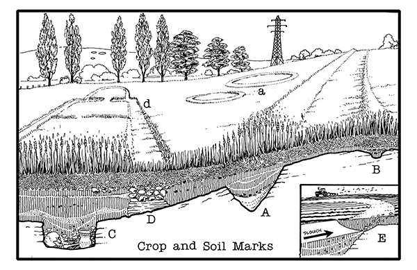
How Crop and Soil Marks are formed illustrated by D. R. J. Perkins.
Today’s image for Day 252 of the VM_365 project is an illustrations produced by Dave Perkins to explain how crop and soil marks, indicating the presence of buried archaeological deposits, form in the growing plants in Thanet’s agricultural fields. These cropmarks are usually identified by aerial photography.
Pits or ditches that have been cut into the bedrock retain moisture in dry spells and crops planted above them grow taller and darker (A) and (a). The intensity of the cropmark vary, shallow features give only faint marks (B) and deeply buried remains can produce nothing at all (C). Buried masonry, where there is less moisture and soil for the crop to grow, produces a negative mark, where the crop is shorter than the surrounding area (D).
Soil marks result when ploughing brings different coloured material from ancient deposits to the surface of a field (E).
Crop and soil marks have been a valuable resource for plotting archaeological sites over very large areas of agricultural landscape, particularly in the central agricultural areas of Thanet outside the main towns. The presence of mapped cropmarks has helped to predict what archaeological features may be found before excavations have taken place. However although they have been a good indication of the scale of buried sites, excavation has often revealed considerably more detail and complexity which was not present in the cropmarks.
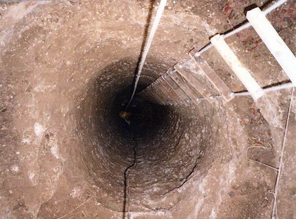
Today’s image for Day 251 of the VM_365 project shows a Medieval well shaft under excavation at Little Cliffsend Farm between 1985 and 1987.
The well head, which was lined with sandstone boulders, was discovered in 1985 when a large hole opened up in the fields above the cliff top overlooking Pegwell Bay. The hole had been caused by the soils filling the well shaft collapsing into an open void lower down.
The backfill of the shaft was excavated by members of the Thanet Archaeological Unit under the direction of Dave Perkins and Len Jay, to a depth of more than 16 metres before the water table was reached and it had to be abandoned. If you look closely at the base of the shaft you can see the yellow hard hat of one of the excavators.
The well, dated by pottery sherds to the 14th century, was cut into the solid chalk bedrock and featured handholds in the sides, presumably cut to allow the original excavator of the well to enter and exit more easily. Similar well shafts have been exposed in the cliff face at Pegwell Bay nearby.
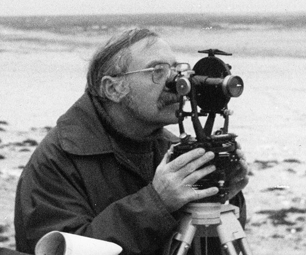
Today’s image for Day 250 of VM_365 is a picture of David Perkins, the first Director of the Trust for Thanet Archaeology.
Dave was born an brought up in Ramsgate and his passion for the history of Thanet was inspired by his father’s love of historical subjects and his grandmother’s tales of local life and folklore. He first trained as an artist specialising in book and technical illustration and followed various careers as a commercial artist and running a business designing and manufacturing leather goods before being introduced to archaeology as a career later in life at the age of 38.
His introduction to archaeology came during a visit to the excavation of a Neolithic and Bronze Age site at Lord of the Manor, Ramsgate in 1976, he volunteered to help on the same day and his illustration skills were soon in demand. He progressed quickly from volunteer to full time supervisor working on archaeological projects with the Isle of Thanet Archaeological Unit and the Manpower Services Commission Youth Training Scheme including the excavation between 1978-9 of the Medieval Church of All Saints, Shuart with Frank Jenkins and the discovery and recording of the shipwreck of the HMS Stirling Castle off the Goodwin Sands in 1979. An early career highlight for Dave was the excavation of over 300 graves at the Ozengell Anglo Saxon cemetery, Lord of the Manor, Ramsgate between 1977 -1980.
In 1982 the Isle of Thanet Archaeological Unit began compiling its own sites and Monuments record for use in research and local government planning some years in advance of the creation of a county wide record. David Perkins was instrumental in collating the Thanet Sites and Monuments Record and was assisted by volunteers from the Isle of Thanet Archaeological Unit and the Manpower Services Commission. The five years that the record took to research between 1982 and 1987 revealed to David that Thanet’s archaeology was of national importance.
In 1988 The Trust for Thanet Archaeology was formed as a professional archaeological unit for Thanet with Dave serving as its first Director until his retirement in 2003. The first excavation carried out by the Trust was the recording of a Bronze Age settlement on the foreshore at St Mildred’s Bay in 1988; today’s VM_365 image shows Dave surveying the site using a theodolite.
Formal qualifications through part time study were added to his growing professional reputation including a BSc in archaeological science from the Polytechnic of East London (East London University) followed by an MSc gained through studying Roman and Anglo-Saxon glass. He was awarded a Doctorate by the University of London in 2001 for his thesis on the prehistory of the Isle of Thanet – The Gateway Isle.
Over the years many people heard David speak about his archaeological discoveries on Thanet, or took part in digs with him. Despite battling against the poor health and increasingly reduced mobility caused by a medical condition that had affected him since childhood, he remained an enthusiast for Thanet’s archaeology after his retirement. Dave Perkins last publication on the Bronze Age round barrows of Thanet appeared in the county journal in July 2010 just before his death at the age of 72.
His determination to understand the archaeology of the Isle of Thanet, his enthusiasm and diligent research remain as an inspiration to us as the current custodians of the archaeology of the Isle.
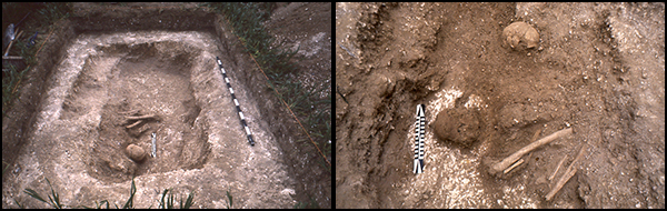
Today’s image for Day 249 of VM_365 shows the Manston Beaker burial under excavation in 1987.
The burial was contained within a grave located centrally within a roughly oval shaped barrow. The crouched skeleton of a slightly built young adult was accompanied by a long-necked beaker, a flint knife and a jet button. The picture on the right hand side shows the burial during excavation with the beaker on the left side of the pelvis.
A secondary crouched burial had also been inserted on the inner edge of the ring ditch to the south of the central grave.
The central grave had apparently been disturbed, possibly by a later burial inserted into the barrow mound, maybe during the Anglo Saxon period, as parts of the skull were missing and a fragment of femur unrelated to this skeleton was found in the backfill above.
Radiocarbon dating carried out on the right femur of the skeleton dates the burial to 1680±50 bc (2132-1922 years BC) which places it at the beginning of the early Bronze Age.
Although the two wings and the central range of the villa appear to be symmetrical, the east wing stands slightly further to the north than the western wing. To compensate for the offset and to link the two wings, the central range was slightly slanted, each room being slightly trapezoidal in plan rather than rectangular.
At some point an extension had been added to the southern end of the west wing, adding an apse and and an L shaped tunnel to form an access from the outside to a furnace. This extension may have been a heated dining room.
Corridors on the front, sides and rear of the wings and on the rear of the main range, provided access to the series of rooms within each building range. The structural evidence indicates that screen walls blocked some of the corridors creating specific routes around the building.
The central range of buildings are fronted with a corridor and portico, linked to corridors attached to the east and west wings, covering three sides of the central yard with a roof. The yard was enclosed at some point with a screen wall at the southern end, with a gatehouse or buttress located on a square foundation at the western end of the wall.
Part of the roof covering the heated apse attached to the north side of the central building in the east west range can just be seen to the rear of the building. The corridors to the rear of the east west range provided access from the east and west sides into the central hall with its heated niche at the northern end.
On the western side of the winged villa, the roof of the detached bathhouse is conjecturally reconstructed with a pair of barrel vaulted roofs covering the various baths and heated rooms.
One of the elements that the reconstruction does not reproduce are the various chimneys and flues that would have allowed the smoke from domestic heathers, heated rooms and bathouses to escape from the roof-line of the building. Perhaps this would have given the villa a more industrial appearance than the usual bucolic views that are given in similar reconstructions of similar Roman villas.
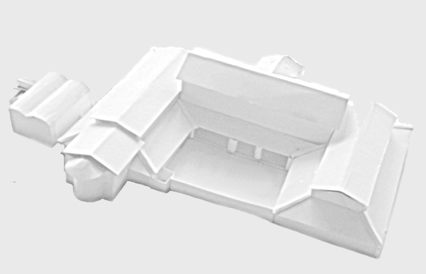
Day 247 of the VM_365 project is our penultimate post on the series of images of the main buildings of the Roman Villa at Minster in Thanet, a view facing north west across a building located at the south west corner of the villa complex.
The excavation of building 6 revealed a more complex story where at least three phases of structure were traced in the same area. The original two roomed building that had been added to the south west corner of the boundary wall was similar in plan and construction to the core of Building 6. However, soon after it was built it was converted into a bath house through the addition of extra rooms and a furnace feeding a hypocaust. As the villa had a detached bathhouse within the western side of the walled compound, it is not clear whether the two bath houses were operated at the same time.
Later still the extra buildings of the bathhouse were removed and the furnace and hypocaust were backfilled with debris. The two chambered structure was restoredmon a new set of foundations.
Behind the building at the far end of the trench, a circular pit can be seen in the image. The pit was the upper cut of a deep well, sunk into the crest of the valley beyond, which may have supplied water to the bath house adapted from the two room building. The fills of the well contained large quantities of broken pottery and some more delicate finds such as the leaf shaped pendants shown in the post for VM_365 Day 31.
The complex series of construction, conversion and replacement demonstrated how a major building like the Minster villa was frequently altered and adapted to suit the present needs of the two or three generations of people who may have occupied it, despite its relatively short life and eventual demolition in the Roman period.
The image for Day 246 of the VM_365 project shows a north west facing view across another of the elements of the Minster Roman villa complex, a small corridor house (Building 4). This structure stood approximately 80 metres to the south of the main villa, immediately outside the south east corner of the wall surrounding the winged villa building. The building was placed on the southern limit of the plateau occupied by the villa and its boundary wall and outer structures. Along the top of the picture the break of slope of the plateau, leading to a valley on its western edge, is visible. The detached bath house shown in the post for Day_245 had been placed on this crest so its drains could discharge into the valley. The location of the bathouse in this image is approximately in line with the gap at the right hand end of the row of trees at the base of the valley.
Several phases of construction could be identified from the foundations of the structure at the southern corner of the villa compound. In the first stage a rectangular building, which was divided into two square rooms by a central wall, had been erected on the south side of the boundary, using the wall as the northern gable. The rectangular building was surrounded on the south, east and west sides by a narrow corridor. The small hypocausted room, which was featured in the VM_365 post for Day 243, was inserted into the south western corner of the corridor. Later the northern end of the corridor was widened and extended northwards beyond the original line of the boundary wall, which had presumably been removed.
Much of the building had been robbed of usable materials when it was abandoned in the Roman period. The pottery recovered from the buildings suggests that it was constructed soon after the mid 2nd century, abandoned by the mid 3rd century and robbed of its building materials in the late 3rd or 4th century. Intensive ploughing had also reduced much of the surviving structure and only the sub floor of the small hypocausted room survived because it stood in a rectangular cutting that extended to a depth below the level of the wall foundations.
The trenches cut to remove the building materials were backfilled with soil, fragments of Roman brick and tile and loose flint cobbles, which had not been collected to be used again. Fragments of crushed mortar and small pieces of painted wall plaster in the trenches probably derived from the building, indicated that the small building was finished and decorated to a similar standard to the main range of the villa, suggesting it was a small detached house rather than a service building.
 Today’s image for Day 253 of the VM_365 project shows a Roman copper alloy bracelet found within the 3rd to 4th century grave of a young adult female at Grange Road, Ramsgate in 2007. The complete pennanular bracelet is shown in situ in an image for