Category Archives: Bronze Age

VM_365 Day 290 Burial at centre of small round barrow at North Foreland

VM_290

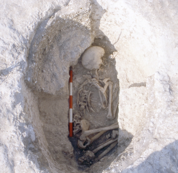
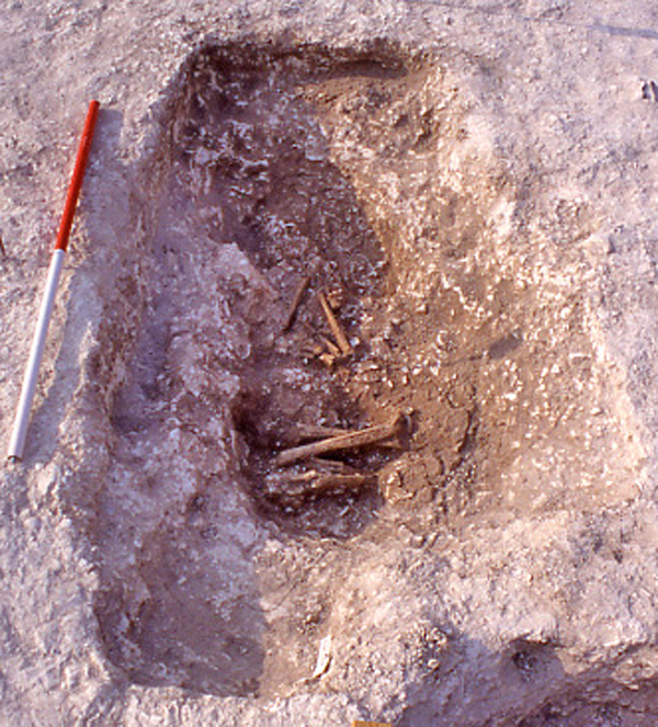
The image for Day 290 is of a burial that was located at the centre of the  platform within the ring ditch of a Bronze Age round barrow which featured in the post for Day 289.

The main grave cut containing the burial was rectangular in plan, measuring approximately 1.75 metres long and 1.05 metres wide. The corners were rounded and the sides were vertical on the northern and southern edges. The eastern and western edges had steep slightly curved sides and the whole feature only measured 0.3 metres deep. The base of the cut was rough and uneven and the burial itself was contained in a slight rounded hollow, aligned approximately north east south west, which lay at the base of the rectangular cut. A chalk deposit with an inner edge that corresponded with the edges of the hollow in the base of the grave cut suggests that like other graves on this site it was retained by a coffin structure which did not survive.

The skeleton had eroded considerably, with only solid long bones left to indicate the original layout of the burial; their position within the grave suggests that the body had been placed in a crouched position with the head to the south, facing west.  Although the remains were poorly preserved and fragmentary, enough remained to be able to determine that they were the bones of an adult, aged approximately 25 -35 years old.

The deposit immediately above the skeleton, within or above the coffin, incorporated fragments of charred wood along with charred wheat and barley grains. Two small sherds of early Iron Age flint tempered pottery found in this deposit seem to be intrusions from the heavy truncation from the later Iron Age settlement on the site.

Despite the poor level of survival of this grave, much information remained to be discovered through the excavation and analysis of the grave and the burial.

VM_365 Day 289 A small Bronze Age barrow with big stories to tell

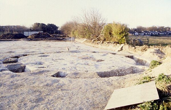
VM 289For the image on Day 289 we have a picture of the ring ditch of a small round barrow,  located at the western edge of the St. Stephens College excavation site at North Foreland, Broadstairs. The barrow stands on the crest of the chalk ridge with the land falling away to the north and north west.

The ditch was formed of two fairly regular arcs, joined by a short straight ditch at the southern end which created an almost complete circuit with a diameter of 9.6m. On the northern side of the ring ditch a 0.4m gap between two square ended terminals formed a narrow causeway from the outside to the inside of the circuit. The small dimensions and irregular shape have been compared with a barrow of similar dimensions that was found at South Dumpton Down, Broadstairs. The primary burial at Dumpton Down dated to the Beaker period, in the Early Bronze Age, suggesting the barrow at North Foreland dates to the same period.

The ring ditch at North Foreland was excavated by digging fourteen segments at regular interval through the dark loam deposits with irregularly distributed chalk and flint inclusions that filled the ditch. A flat based profile with very steeply sloping or near vertical sides was exposed along the whole length of the ditch, which only survived to a depth between 0.42 and 0.57m;  the width varied from 0.75 and 0.9m.

Like many of Bronze Age barrows featured in the VM_365 posts, on Day 271 and Day 286,  several of the upper fills of a ditch originally cut in the Early Bronze Age contained pottery dating to the Iron Age. Like the other barrows, this small example must have remained as an earthwork in the landscape, only to be completely filled in the later Iron Age period.

Two grave cuts were identified within the circuit of the barrow ditch; one positioned centrally and the other on the southern edge. Another more unusual grave cut was  found cut into the base of the north western arm of the ring ditch, these will be explored in more detail in later VM_365 posts.

VM_365 Day 288. Secondary Bronze Age burial within refurbished Barrow at North Foreland

VM 288

Today’s image for Day 288 of the VM_365 project shows a small oval grave that was located on the inner north west edge of a refurbished ring ditch, which was featured on Day 286 of the VM_365 project.

The skeletal remains were in a tightly crouched position, with the arms and legs flexed suggesting the body may have been tightly wrapped. The body, possibly a male aged between 14 -16 years old, had been placed on its left side, with its head  facing east at the north end of the grave cut.  The upper body was twisted so that the skeleton lay almost face down.

The grave cut was much smaller than the  burial that was placed at the centre of the original ring ditch, measuring just 1.04 metres long by 0.7 metres wide and with a depth of 0.5 metres. There was evidence that a coffin or containing structure, perhaps a woven basket, surrounded the immediate area of the burial.  A void around the skeleton had been filled by a deposit of silty clay derived from decay of organic matter and the percolation of silts from the surrounding deposits. The finer soil was retained within a chalky grave fill packed around the body, some of which is shown still in place in the picture above. The clean white chalk of the undisturbed chalk geology can be seen at the outer edge of the regular eliptical cut.

The upper fill of the oval grave pit incorporated the remains of a secondary burial, represented only by some unfused fragments of vertebrae and teeth, suggesting  a juvenile. No evidence of a secondary grave cut through the fill of the earlier burial  was identified during excavation. A small sherd of worn early Iron Age flint tempered pottery was found near the primary burial, but it is thought this may have intruded into the fill when the second burial was inserted in the early Iron Age.

The sequence of burial and the refurbishment of the ring ditch that defined the edge of the barrow show that once these structures were built, they  were sustained as places of significance over many centuries and cultural changes. Their meaning to each successive generation may also have changed but their physical presence was a fact in the landscape which only reduced in definition and scale over a long period of time, and could when necessary, be restored to gain new importance.


VM_365 Day 287 Central burial, Bronze Age Barrow, North Foreland

VM 287

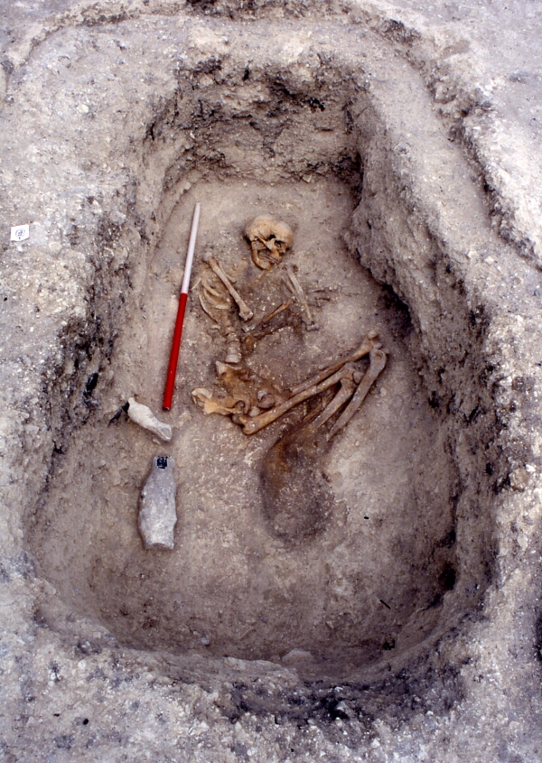
The image for Day 287 of the VM_365 project shows the burial that was located at the  centre of the ring ditch of the Bronze Age barrow that featured on Day 286 of the VM_365 project. A second burial, probably inserted at a later date and associated with the refurbishment of the ditch circuit, was located on the northern edge of the Barrow platform

The large rectangular grave cut measured approximately 2.6 metres long by 1.6 metres wide and  was 0.76 metres deep, with a north east  to south west orientation. The skeletal remains of a mature adult male, aged approximately 30-40 years old were found at the base of the cut. The body been placed on its left side in a crouched position with arms and legs flexed, facing east. The head lay at the northern end.

In the image a chalky fill remains in the grave after a softer inner deposit had been removed to expose the skeleton. The soft deposits surrounding the body suggest that it may originally have been placed within a coffin, or similar structure such as a wicker basket which retained the chalky fill against a vertical edge. The inner area retained by the structure measured approximately  1.05 metres wide by 2.08 metres long. This was placed in the northern half of the grave cut and the space left at the foot of the grave may have contained food or other offerings which have not survived to be recovered in the excavation. The grave seems to have been backfilled around the inner chamber soon after the coffin was deposited in the grave.

In the upper fill of the grave there were 44 sherds of Early Iron Age flint tempered pottery and fragments of charred wood, which may be associated with disturbance from the Iron Age settlement that was established around the barrow.


VM_365 Day 286 Bronze Age Barrow, refurbished in the Late Bronze Age

VM 286For Day 286 of the VM_365 project we have an image that shows another of the ring ditches of a Bronze Age barrow, excavated at St Stephen’s college, North Foreland in 1999.  The ring ditch was shown in an  overview of the site which was the image featured on Day 284 of the VM_365 project.

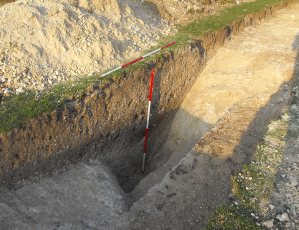
The picture on the left shows the barrow ditch under excavation, with a series of segments being excavated from the fill to show the layers of deposits in profile. The picture on the right shows the profile of one of the excavated segments  showing the sequence of multiple fills and interfaces in section, revealing that the circuit that was seen in the ground was in fact formed of two superimposed ditches cut at different times. The earlier ditch circuit had been at least partly filled in and had been refurbished by digging a new circuit around the same footprint.

The original ring ditch, measuring 18m in diameter, was probably cut in the late Neolithic/Early Bronze period, contemporary with a burial that was located at the centre.  The earlier ditch cut was slightly irregular, having been formed of a series of  straight segments in a similar manner to the ring ditch shown on Day 285. The profile measured approximately 1.5m wide and varied between 0.6 and 0.7m deep. The earlier ditch had been cut with a flat base, with steeply sloping sides angled at approximately 60°, part of this flat based profile can be seen in the right hand side of the picture of the section on the right.

The surviving fills of the primary cut which had not been removed by later activity  consisting of thin laminated bands of loam and chalk fragments, often with a fine graded appearance suggesting the erosion of the chalk barrow mound and edges of the ditch. It is likely that the earlier ditch had filled entirely before it was recut along the same circuit, probably in the late Bronze Age. This time the ditch cut had a steep V shaped profile, which cut away one side of the old circuit and penetrated the chalk below the flat floor as well.

The intersection of the two different cuttings can be seen most easily in the right hand image, by following the chalk in the cut from left to right. The steep side of the original ditch breaks to the platform of the original base, which then breaks sharply at a steep angle to the V shaped notch cut by the new circuit. The right hand side of the notch rises at the same angle along the inner edge of the new ditch cutting.

The later refurbishment of the barrow by cutting a broader ring ditch with a V shaped profile through the filled earlier ditch suggests the original barrow may only have existed as a raised earthwork rather than a ditch, although it may have been an impressive feature even after years of weathering.

Why was the ditch circuit recut on the same plan?

Two grave cuts were identified within the Barrow platform. Because of its regular placement in relation to the circumference of the ditch,  the central burial is likely to be associated with the original construction of the Barrow. It is possible that the other burial, which lay in a smaller oval cut,  may be associated with the refurbishment.

The newly cut ditch probably also remained a prominent landscape feature for centuries, its ditches still visible as deep hollows around the circuit. The  post for VM_365 Day 271 featured a bronze age barrow ditch that must have still been a substantial earthwork in the Roman period when large amounts of pottery were tipped in to its upper fills.

In the upper fills of the recut ring ditch at North Foreland pottery in transitional Late Bronze Age/Early Iron Age fabrics was found in relatively large quantities, along with small amounts of 6th century BC pottery contemporary with the earliest occupation features of the  Iron Age, suggesting that the final filling of the re cut barrow occurred early in the Iron Age when the hill top was being turned into a nucleated settlement, with enclosures and clusters of post built structures, served by a major trackway leading from the sea.


VM_365 Day 285 Bronze Age Roundbarrow?

VM 285

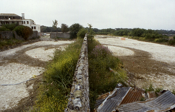
The image for Day 285 of the VM_365 project shows one of the three ring ditches that were excavated in 1999 at the St Stephens College site, at North Foreland, Broadstairs. The cropmarks extending along the valley side (to the right of this image) were shown on Day 283 and an overview of another of the barrows, an Iron Age enclosure and storage pits (located in the area at the top of this picture) were shown on Day 284 of the VM_365 project.

Two sections of this ring ditch, which are assumed to be a continuous circuit, were exposed on either side of a standing flint wall, which is part of an early 19th century Grade II listed structure and was left in place. No internal graves were found which could confirm that the ring ditch was a round barrow, but as the central part of the feature was obscured by the wall and an unexcavated area either side of it, a central grave could perhaps exist there.

The ring ditch measured 21m in diameter was formed of a series of  fairly straight cuts, each roughly 2.5m in length, which intersected at acute angles to form a ring. The profile of the ditch was fairly consistent measuring 0.74 metres deep with steep, approximately 60° edges and a flat base. The fills of the ditch did not indicate any bias in the direction of filling  to suggest the presence or composition of a central mound enclosed by the ditch.

Pottery of Early Iron Age date was found in the uppermost fills of the ditch, which were presumably incorporated when the ring ditch was almost entirely filled and the major Iron Age settlement was established to the south in the early 6th century BC, replacing the Bronze Age pattern of landscape use for funerary monuments with a  hill top village.


VM_365 Day 284 Excavation of a Prehistoric site at North Foreland, Broadstairs

VM 284

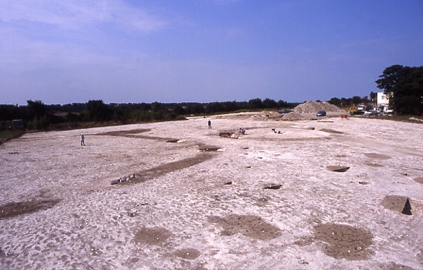
The image for Day 284 of the VM_365 project shows archaeological excavations in progress in 1999, at the site of St Stephen’s College, at North Foreland, Broadstairs. The view in this picture faces north west toward the mouth of the Thames Estuary, although the sea is hidden behind the range of trees at the top of the picture.

The  St Stephen’s College dig site is located just to the east of the cropmark group at North Foreland that was shown in yesterday’s image for VM_365 Day 283. One of the ditches that shows in the cropmark extended into the site.

The wide range of features found on the site are all represented in the picture. On the top, right hand side is the ring ditch of one of three Bronze Age round barrows excavated on the site. This barrow contained three burials, a large rectangular central grave cut and a second, smaller, oval grave cut on the northern side of the Barrow. A second burial had been inserted in the upper fill of that grave. The circuit of the barrow ditch had been recut in the Iron Age, possibly to form a hut platform.

On the left side of the picture you can see the ditches of an enclosure, dating to the Middle Iron Age. An  entrance causeway formed by a break in the ditch circuit can be seen at the front. Some of the ditches that branch to the top of the hill from the trackway that can be seen in the cropmarks on the hillside lead directly to the rectangular encloure.  At least six structures built with four timber posts were enclosed within the rounded rectangular ditch, although these could be from a different phase of the settlement when the ditch was no longer visible.

The group of storage pits visible in the foreground, close to the entrance of the enclosure, were dug over a period of time spanning the Middle to Late Iron Age.  One of the storage pits located in another part of the site, not shown in the image,  was reused for a burial which featured in a sequence of VM_365 posts on Day 123, Day 43 and Day 113. Iron Age objects found in some of the pits excavated on the St. Stephen’s site including Bridle bits, a bone handle, loom weights and evidence for chalk plastered structures have also been posted as part of the VM_365 project.

The tiny figure present in the middle of the enclosure is the Trust’s first Director Dr Dave Perkins who led the excavations in 1999.


VM_365 Day 271 What’s in a ditch? Bronze Age barrow dimensions

VM 271
Segment excavated through Bronze Age Barrow at Westgate in 2011. Scale shows 0.5m increments.

Today’s image for Day 271 of the VM_365 project shows a segment excavated through a well preserved ring ditch surrounding an Early Bronze Age barrow during an archaeological evaluation carried out at Westgate in 2011. The location of the barrow ditch, with a diameter of approximatley 27 metres, had been identified by aerial photography.

The evaluation established that the well preserved profile of the ditch was cut into the chalk geology to a depth of 1.4 metres from the base to the interface with the subsoil. Although the section shown in the image is cut slightly obliquely across the width of the ditch it gives a good impression of its large dimensions. At its widest point across the top the ditch measured 2.3 metres; the flat base was 1.3 metres wide.

A mound would have been built from the soil and chalk taken out of the ditch to cover a burial in a grave at the centre of the barrow. The ditch profile near the flat base was  very steep sided, but the angle of the upper edges of the cut sloped more gently, creating an angled shoulder on the inner edge of the ring ditch.  The limits of the shoulder allow us to estimate the diameter of the mound as a maximum of 22 metres and its possible original height as around 10-11 metres, assuming that the sides had as much as a 45 degree slope when it was originally built. Soil compression and slipping of the edges would have quickly reduced the height and angle of the mound unless it had been carefully compacted or structured in some way.

As the grave of a significant individual in the Early Bronze Age, we assume that the ditch was kept clear and that the mound was maintained to some degree, preserving its height and function as a monumental marker in the landscape. When it was abandoned the chalky covering of the mound began to erode into the ditch, filling the base with clean chalky material. Later more silty deposits accumulated in the hollow left by the ditch, derived from the soil that formed over the mound and the surrounding landscape.

It is often assumed that the decaying  mound and ditch would have been a significant feature in the landscape, attracting later communities to reuse it for burisls and as a significant feature in the landscape. It is not often that the survival of a barrow mound or ditch can be dated. However the silty deposits that made up the upper fills of this barrow ditch contained abundant fragments of pottery, dating from as early as the middle Iron Age to the Roman period, in the 3rd century AD. This dateable material indicates that the hollow of the ditch remained a prominent feature, accumulating debris from nearby settlements many centuries after its builders and their successors had stopped looking after the monument.

How visible this feature was in the later Roman, Saxon and medieval periods we will never know as the most significant erosion suffered by the ring ditch and mound probabaly resulted from agricultural activity in the early 20th century and the eventual levelling of the site for recreational use.


VM_365 Day 266 The barrow reconstruction drawings get more complicated

VM 266

The image for Day 266 of the VM_365 project is the second in a series of images drawn by Dave Perkins, reconstructing the sequence of event associated with a funerary monument that was revealed in excavations at Lord of the Manor, Ramsgate.

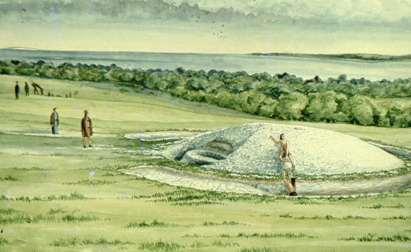
In today’s image, the single ring ditch and mound that was shown in yesterday’s picture is being renewed, ready to receive another burial. The original ring ditch and its mound, now compressed and discoloured, have been sealed under fresh chalk which is being dug from a new ring ditch with a greater diameter than the earlier one. The circuit of the new ditch is  interrupted by a causeway, where a stretch of the circuit was not excavated. It is a process like this that created the concentric circuits of ditches that show up so well in the cropmark posted on VM_365 Day 264.

The location of the barrow is closely based on the landscape of the Lord of The Manor site, with the land falling away into a deep dry valley, which is shown covered with woodland. The sweep of the valley leads to the sea at Pegwell Bay in the upper right hand side of the picture. On the left side of the image a funeral procession is making its way up the side of the valley toward the newly refurbished barrow.

It is still possible in the present day to stand near the site of the barrow and see the same view over the bay which would have been presented to the prehistoric people of the area.  It was this experience of the landscape that Dave Perkins used to draw his reconstruction images.

Further analysis of the landscape has shown that there are only a few sites in Thanet’s landscape where such an uninterrupted view is possible and it becomes clear from considering the landscape that sites were carefully chosen to provide such a panoramic view. Excavations have shown that some were used over many thousands of years to locate settlements, gather for ceremonies and to create structures where the dead could be buried.

Once again we can reconstruct the facts that are presented by the archaeological features on the ground, but can never really confirm the reasoning behind the choice of location which is so well captured in the drawing. Was it to assert a power or domination over the landscape or to enhance the visibility of the monument from other sites? Motives may have changed over time passing from willful choice into tradition whose meanings were lost in the passage of time.

The true motives are lost without the record of contemporary voices, but we can explore possible meanings through attempts at reconstruction like the drawings in this series of posts. There are questions to ask about this reconstruction: was the natural environment so open and free of the influence of man as it is shown? Was it as simple a task to create a barrow as is suggested? The ring ditches of the many barrows that have now been excavated in Thanet have demonstrated that they are often perfectly circular with regular and symmetrical profiles throughout the circuit, despite the hard chalk rock that had to be cut to create them. It is immediately possible to suggest the picture could be made more accurate with the addition of some figures carrying out some quite complex surveying and architectural control over the cutting of the ditch as well as an indication of the greater amount of labour that went into cutting away the chalk in such quantity. Our ideas progress through such criticisms of the reconstruction, which perhaps leads in the future to new images that take new ideas on board. Sadly they will not have the benefit of Dave Perkins’ wisdom and experience to inform them.

VM_365 Day 265 Art inspired by the Lord of the Manor prehistoric archaeology

VM 265

The image for today’s post on Day 265 of the VM_365 project is an illustration by the Trust’s first Director David Perkins, inspired, as much of his work was,  by the landscape and prehistoric archaeology of Lord of the Manor Ramsgate.

The archaeological excavations that were carried out to explore the many features that were revealed by aerial photography in the area near Lord of the Manor were very significant to understanding the scale of prehistoric settlement in Thanet.

Using their experience of digging several of the major sites  revealed in the Landscape, both Dave Perkins and Len Jay used their artistic skills to record their activities and to interpret the sites they  were uncovering.

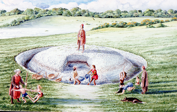
The coloured drawing  by Dave Perkins recreates a scene associated with the insertion of a new burial into the mound of one of the prehistoric round barrows located at the crest of the hill, an event that was attested in the archaeological record.

The stark white of the chalk that lies  at a shallow depth below the soil are visible in the cut of the ring ditch and the central mound where it was cast over a primary burial located at the centre. Baskets and shovels show that the ditch has been newly cleaned to refresh the surface of the chalk. The scene shows the mound as having been partly removed, so that another burial can be inserted within the circuit of the ditch. The later burial is perhaps that of a member of family who wishes to be close to a relative, or perhaps a clan member who wants to remind his followers of the source of his power. The burial may be of an unrelated individual who want to claim a connection with the glories of a bygone age. Grieving family members, along with warriors and perhaps elders of the clan are shown outside the ring ditch, while the person to be buried is carried across the ditch to the new grave.

Although the drawing reflects  the archaeological facts that were established from the sequence recovered from the ground, the truth of the scene’s representation of Bronze Age culture can never be known as there are no records to guide our interpretation with certainty.