Category Archives: Post Medieval

VM_365 Day 338 West Northdown, Cliftonville

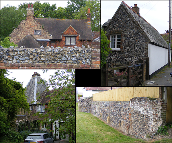
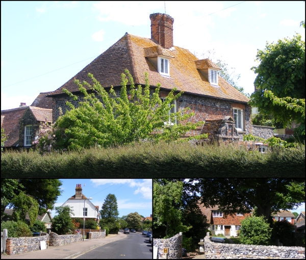
VM 338Today’s image for Day 338 of the VM_365 project continues our Hidden Hamlet series and shows the surviving elements of two farms at West Northdown, Cliftonville which are now completely surrounded by suburban development.

The main image at the top shows West Northdown Farmhouse which is located on Omer Avenue. The former farmhouse was originally constructed in 1652 and the date is recorded on the west side of the house in brick. This lovely Dutch gabled building is built of squared knapped flint with brick dressings; the first floor is decorated with red brick in a diaper pattern.

West Northdown Farmhouse was largely still surrounded by agricultural buildings and by open farm land until the early 1900’s when it is labelled on Ordnance Survey maps as being part of Dairy Farm.  A second farmyard located around 50 metres or so south east of the farmhouse is labelled as Omer Farm. By the publication of the 1936 Ordnance Survey map both Omer Farm and Dairy Farm have been sold off, the agricultural buildings demolished and new houses erected along the newly constructed Omer Avenue which extends north between the locations of the two farms.

The only surviving original element of Omer Farm appears to be a flint wall which extends along the western side of the street frontage on the opposite side to West Northdown Farmhouse. An interesting building (bottom left) is located on Omer Avenue, set back from the street front and located in what would have been one of the yards of Omer Farm. This building at first glance appears to be of a similar date to West Northdown Farmhouse but is in actual fact a cottage built in 17th century style in 1933 using old materials probably recycled from the demolished farm.


VM_365 Day 337 The Follies of Kingsgate Bay

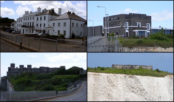
VM 337Today’s image, for Day 337 of the VM_365 project and another in the Our Thanet series, shows four views of some of the ‘follies’ at Kingsgate Bay, Broadstairs that were constructed by Henry Fox, Lord Holland, in the 18th century.

Henry Fox served as a Whig politician between 1735-1765 and was the father of the Honourable Charles James Fox, another famous Whig Politician. As Lord Holland he held various posts including Paymaster-General of the Forces, a post that he used  to increase his personal fortune from the public purse and from which he was finally forced to resign in 1765.

Lord Holland came to Kingsgate in 1761 to escape his political life and public hatred. Kingsgate Bay had formerly been called called Bartholomew’s gate but gained its present name from the landing of Charles II at the bay in 1683.  A medieval arch and portcullis once defended the ancient gap through the cliffs, but it was destroyed by gales in 1819.

Lord Holland built a house and surrounded it with follies, structures built in the style of ruins from antiquity, which were then fashionable. Holland House (shown in the top left of the picture) was constructed in classical style around 1760. The house  fell into ruins around the end of the 18th century and most of the present façade dates to the mid 19th century when it was rebuilt. The original central portico of the  Holland House was removed to the Sea Bathing Hospital at Margate.

The follies at Kingsgate included a Bede-House, a Castle, a Convent and a temple, although most of the Follies concealed practical purposes. The Bede-House (in the top right of the picture) was constructed on the cliff on the western side of Kingsgate Bay in the late 18th century as a house of entertainment for visitors who flocked to see all of Lord Holland’s follies. By the early 19th century the building had become known as the Noble Captain Digby, after a nephew  of Lord Holland who commanded HMS African at Trafalgar. Much of the original structure was destroyed when it fell into the sea during a strong gale, but surviving parts of the earlier structure are incorporated into the mainly early 19th century construction of the present Captain Digby Inn.

The temple of Neptune on White Ness (in the bottom right of the picture) was built in the late 18th century as a miniature copy of the Tudor blockhouses at Camber and Deal which Henry VIII used to defend the south east coast. In the Second World War the temple tower served as a post for the Royal Observer Corps. In the same year that the Temple of Neptune was built, a respected local Vicar recorded his opinion that a tower named the Arx Ruohim, or tower of Thanet, had been built on the same site by King Vortigern in A.D. 448. The story was taken as fact and even gained places on reputable maps and in local guidebooks and as a result people came to to look at the ‘Saxon’ Tower.

Kingsgate Castle (bottom left of the image) was a copy of a Welsh Castle and was  constructed on the cliff top on the eastern side of Kingsgate Bay. This building was used as stables by Lord Holland but eventually fell into disrepair. A large round tower is all that remains of the original building. The structure was added to over the years and later rebuilt in 1913 by Lord Avebury, incorporating most of the original fabric. The building has been converted into residential flats in recent years .

Another of the follies was known as the Convent (not pictured). Originally built as five cells arranged around a central cloister it was intended to be used as a convent for Anglican Nuns, but they  never occupied the building. Instead the Convent was used as accommodation for the poor and industrious members of Lord Holland’s estate and also used as overflow accommodation for guests at Holland House. By 1831 the convent was rebuilt and renamed Port Regis. The remains of the medieval entrance to Bartholemew’s gate were rebuilt in the grounds.

Another commonly held ‘historical fact’, probably originating in similar circumstances to the Arx Ruohim myth, is still preserved in a local place name ‘Hackemdown’,  which is even recorded on Ordnance Survey maps. The name derives from an ‘historical event’, which was actually invented by Lord Holland. A barrow mound in the grounds of the convent was opened by Lord Holland and enough human remains were found for Lord Holland to suggest they were buried after a battle between Saxons and Danes. Lord Holland commemorated his invention by building a tower on the site of the barrow mound, complete with an inscription to the dead. The tower became known as Hackemdown Tower and other barrow mounds nearby became known as Hackemdown Banks. The cliff which Holland suggested the remainder of the dead from the battle were pushed became known as Hackemdown Point.

While Lord Holland’s battle was pure fiction, it was based on real archaeological finds. Holland was prompted to open his barrow mound after a farmer at Reading Street Farm had opened a larger mound nearby in 1743, in the presence of many hundreds of people. Records suggest that deep in the solid chalk under the mound several stone capped graves were found. Human skeletons bent almost double and several urns of coarse earthenware filled with ashes and charcoal were reported to have been found. Both the mounds opened by the Reading Street farmer and Lord Holland are more likely to date to the late Neolithic or Early Bronze Age.
VM 365 Day 333 Hidden Hamlet of Upton, Broadstairs

VM 333

Today’s image for Day 333 of the VM_365 project shows a series of views of surviving agricultural buildings in the now hidden hamlet of Upton which is located on the eastern side of Broadstairs.

The main focus of the former hamlet is located around the junction of Fair Street and Vale Road. This picturesque corner of Broadstairs contains a number of buildings and features reflecting its rural past that are easily visible from the road.

The oldest surviving building is Little Upton, shown in the top left of the image. This Dutch gabled house was constructed in the late 17th century in two sections with different roof levels and is located on the northern side of Vale Road.

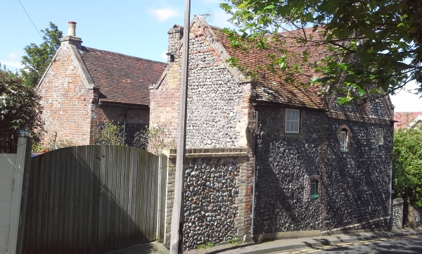
On the opposite side of Vale Road you can see the remnants of Upton Farm which incorporates an Oast House, (bottom left)  probably originally constructed in the 18th century as a timber framed single storey barn. The pyramidal slate cap on the left side is a mid 19th century construction. If you look at the brick gable end that faces on to the footpath you can see where the roof has been raised probably in the 19th century.

Other buildings hinting at the area’s rural past can be seen along Vale Road (top right) where long, narrow flint built buildings are located side on to the street aligned along the edge of  the former farmyard. Near the junction of Fair Street is a long brick and flint wall forming the boundary to a cottage. This wall has many phases in its construction and once formed part of an agricultural building or barn that has since been demolished.

There are lots of other elements visible in the street scape around Upton that hint at its rural past which can be easily identified if we take the trouble to really look.


VM 365 Day 332 Lower Gore End Farm, Minnis Bay

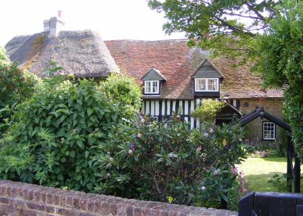
VM 332Today’s image for Day 332 of the VM_365 project shows the farmhouse of Lower Gore End Farm, Minnis Bay, Birchington which was established around 1540 or earlier.
Old Bay Cottage along with Elder Cottage formed the farmhouse of Lower Gore End Farm, all that remains of this farmstead which would originally have been isolated,  away from the focus of the village at Birchington to the east.

The farmhouse was originally detached and was located with its gable end facing on to the farmyard. Historic maps indicate that working farm buildings were located on two sides of the farmyard which faced side on to the route from the village of Birchington to Minnis Bay, now known as Minnis Road.

Old Bay Cottage, on the right of the image, is the oldest part of the farmhouse and was built in the 15th century as a two storey timber framed cottage with a tiled hipped roof and close studded timbers. The porch, which is just visible, was a later addition. The thatched roof visible on the left side of the image belongs to the 18th century extension known as Elder Cottage.

Lower Gore End Farm was quite isolated in the early to mid 19th century and surrounded by agricultural land, with Minnis Creek nearby still flooding nearly as far as the farmstead at the spring tides. It was probably still possible to have a clear view of the parish church of All Saint’s, Birchington from the farm although by the 1870’s new roads were beginning to be laid out at Minnis Bay, west of the relatively new railway line and brickfields were beginning to encroach on the agricultural land. By the late 19th century the farm was nearly surrounded by brickworks and by the 1950’s was surrounded on the north, east and west sides by suburban development focussed on Minnis Bay.

Nowadays the farmhouse is all that survives of the farmstead, completely surrounded by suburban development but still remains as an indicator of the once isolated rural character of Minnis Bay.

VM_365 Day 330 Earliest standing remains of the hamlet of Hereson, Ramsgate

VM 330Today’s image for Day 330 of the VM_365 project shows a pair of cottages that are located in the old Thanet hamlet of Hereson, near Ramsgate.
In the medieval period the main settlement at Ramsgate was the village focussed around the parish church of St Laurence the Martyr. The town of Ramsgate developed from a fishing village in the parish of St Lawrence to a coastal port in its own right from the 16th and 17th centuries onwards. The earliest buildings associated with the develoment of the town of Ramsgate are generally foccussed along the High Street, Ramsgate and High Street, St Lawrence which follows the route from the harbour to the parish church. A grade II listed cottage with Flemish gables, one of the earliest buildings in Ramsgate, featured on Day 6 of the VM_365 project.

The medieval village of St Lawrence was surrounded by other clusters of settements within the parish, including the hamlets of Hollicondane, Hereson, Chilton, Pegwell, Haine, which were generally located close to major farms.

The pair of cottages in today’s image are located on Honeysuckle Road. These buildings are the oldest remnants of the hamlet of Hereson, which was located less than 0.5km east of the town boundary of Ramsgate.  The cottages, with kneelered gables, were originally constructed in locally sourced flint and brick in the 1600’s. The structures were altered in the 19th century.

The urbanisation of Ramsgate in the 18th and 19th and early 20th centuries expanded the developed areas of the town out from the main route to the parish church with a mixture of grand houses and mansion dwellings for the upper and middle classes as well as buildings with industries and public services essential to a growing port trade and seaside destination.   Breweries, public houses, maltings, flour mills, water towers and other public amenities and transport links began to extend outside the early focus of the port. Ramsgate began to encroach on the agricultural land that surrounded it absorbing the smaller hamlets into the urban sprawl.

However, with careful attention to archaeology of the buildings in the town, the hidden hamlets of Thanet can still be traced and many interesting and important buildings survive in the modern town.


VM_365 Day 329 History revealed in the South Chapel of St Nicholas Parish Church

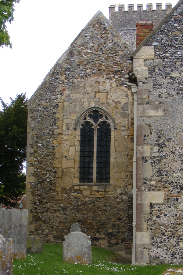
VM 329The image for Day 329 pf the VM_365 project is a view from the east end of the south chapel of the Parish Church of St Nicholas at St Nicholas at Wade. The church itself featured in Day 321 of the VM_365 project.
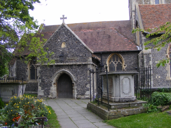
It is often easy to overlook the standing historic monuments when think about the archaeological sites in the environment around us and our Parish churches have many archaeological stories to tell.

The south chapel at St. Nicholas was added to the building when the church was enlarged with the construction of the new east end in the late 12th or early 13th century. New windows were inserted into the building by the late 13th or early 14th century.

In today’s picture one of the inserted windows in the east end of the south chapel can clearly be seen,  the frame set within the old 12th/13th century window frame which has been filled with irregular blocks of stone.

While the complex history of the medieval church can be read from the major changes made to the structure, it is important to remember that the Parish churches continue to evolve architecturally. New architectural elements have been added in more recent times and have made their mark on the building.

In the 18th century the south chapel was used as a parish school and a fire was installed to warm the building for the children and teachers.  A brick chimney stack inserted to draw the smoke from the fire can be seen in the picture, poking out from the roofline on the right hand side of the chapel.

The structural evolution of the parish churches of Thanet can tell us a great deal about the social history of the population.The reconstruction and expansion of the churches demonstrates changes in the size of the local population. In some cases such as at Monkton and All Saints, Shuart showing a substantial decline in population.

The varied uses the churches were put to, in addition to the routine of services and worship show how central a parish church was to a local community in the past. The architectural story of the Parish church buildings has much to offer anyone interested in the archaeology of Thanet.

VM_365 Day 328 South Porch, church of St Laurence, Ramsgate

VM 328

Today’s image for Day 328 of the VM_365 project shows the south porch of the parish church of St Laurence the Martyr, Ramsgate which previously featured on Day 326 of the VM_365 project.

The south porch was constructed in the 15th century around the same time as the upper stage of the tower. The 15th century porch which incorporates a lamp bracket, conceals the original Norman rectangular doorway which is visible inside along with the water stoup.

In front of the south porch you can see two of a number of railed tomb monuments which have been erected in the churchyard. The one to the left of the porch dates to the mid 19th century and the one to the right is of early 19th century date providing another illustration of the complex archaeology of church buildings and their associated yards which were so central to the Christian communities of the early medieval to modern period.


VM_365 Day 327 The Treasury, St John’s Church, Margate

VM 327

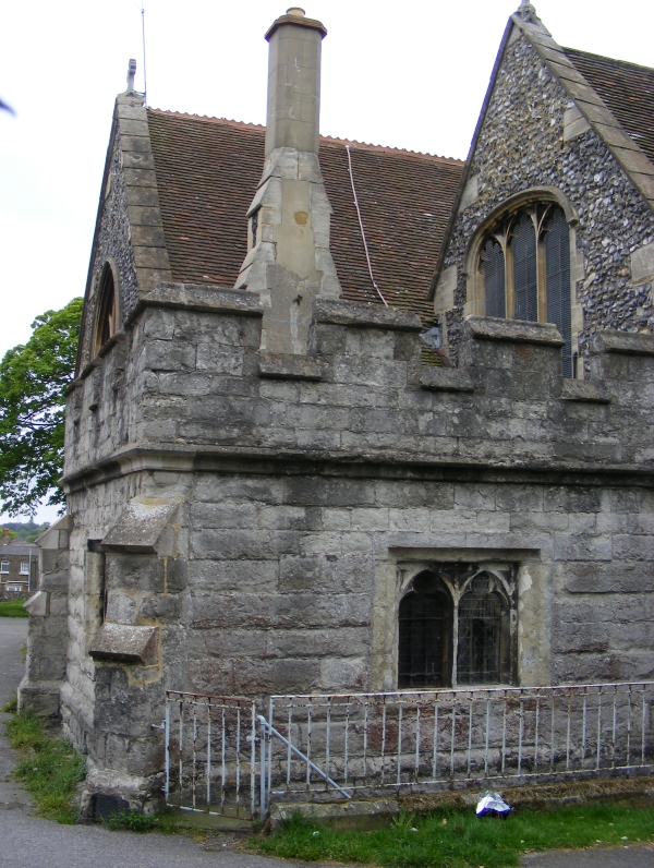
Today’s image for Day 327 of the VM_365 project shows the Treasury which was constructed on the north east corner of the parish church of St John the Baptist, Margate which featured on Day 324 of the VM_365 project.

This single storey addition to the church was constructed around 1500 AD from coursed Ragstone and incorporating a crenellated parapet and traceried windows.  The Ragstone is a distinctly different building material to the rest of the church and was shipped in from the Maidstone area; the rest of the church is constructed mainly of flint which was easily obtainable locally.

Although originally built to be the church treasury, for the storage of the church’s valuables, this structure was later adapted to store shot and gunpowder for the town fort and was also used by the Churchwardens to administer poor relief for the parish. In the early 18th century it became the church vestry.

References/Further Reading

Berg, M. and Jones, H.  2009. Norman Churches in the Canterbury Diocese. The History Press.

Colyer, R. 2012. The Parish Church of St John the Baptist, Margate. A short guide. http://www.stjohnschurchmargate.org.uk/churchfamily-history/the-parish-church-of-st-john-the-baptist-margate-a-short-guide-5/

Historic England 2015. The National Heritage List for Britain: The Parish Church of St John the Baptist. List entry no.1351103. http://list.historicengland.org.uk/resultsingle.aspx?uid=1351103&searchtype=mapsearch

Scurrell, D. 1982. The Book of Margate. Barracuda Books.


VM_365 Day 324 The parish church of St John the Baptist, Margate

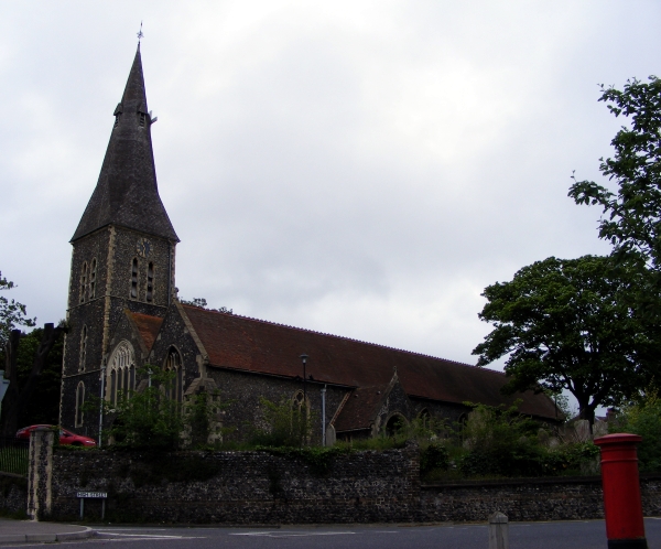
VM 324Today’s image for Day 324 of the VM_365 project shows the large parish church of St John the Baptist, Margate. It is located on high ground about a mile inland from the coast and would have been widely visible throughout the parish before the town became more built up in the 19th and 20th centuries. The church was constructed mainly in knapped flint with some ragstone used later.
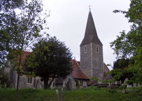
St John’s was a chapel to the mother church at Minster until 1275 when it became a parish church in its own right. There may have been a church here as early as the mid 11th century although parts of the original surviving Norman church were probably constructed in the mid 12th century. The Norman church was much smaller than the current structure although it did have a north aisle of two or three bays and part of the existing north aisle and the chancel arcades date to this phase. The church was significantly extended to the west later in the 12th century and the rest of the north and south aisle were added.

Some of the south and north arcades were replaced in the 13th century possibly to resolve problems with the structure which may have the result of a fire or a collapse. The very tall northwest tower was constructed in the 13th century and the spire was added in the 14th century.

In the late 15th to early 16th century, a treasury built of kentish ragstone with a low pitched roof and crenellated parapet was built at the north east end of the church which suggests that the church had become wealthy enough to need somewhere to secure valuables. It later became the place where the churchwardens administered poor relief and as a secure store for gunpowder and weapons.

The exterior of the church was heavily restored in the 1870’s by the well known architect Ewan Christian.

References/Further Reading

Berg, M. and Jones, H.  2009. Norman Churches in the Canterbury Diocese. The History Press.

Colyer, R. 2012. The Parish Church of St John the Baptist, Margate. A short guide. http://www.stjohnschurchmargate.org.uk/churchfamily-history/the-parish-church-of-st-john-the-baptist-margate-a-short-guide-5/

Historic England 2015. The National Heritage List for Britain: The Parish Church of St John the Baptist. List entry no.1351103. http://list.historicengland.org.uk/resultsingle.aspx?uid=1351103&searchtype=mapsearch


VM_365 Day 323 The parish church of All Saints, Birchington.

VM 323The image for Day 323 of the VM_365 project shows the parish church of All Saints, Birchington. The church is located on high ground approximatley 1.2 km (¾ mile) from the coast and although now  heavily built up,  the landscape would have been open all the way down to the sea until around the mid 19th century. The churchyard is large and open and has been terraced along the hillside to accomodate the 19th century extension to the graveyard.

The church was a chapel to the church at Monkton along with Woodchurch/Acol and was part of the possessions of Christ Church Priory, Canterbury until the Dissoloution when it was passed to the Dean and Chapter of Canterbury.

All Saints was constructed in the 12th century or earlier using flint and Caen stone and had already been aisled by the late 12th century. The earliest surviving fabric exists in the lower outer aisle walls, with some reused Caen stone blocks in the upper face of the south west aisle and the south doorway, although restored in the 1860’s, retains two capitals dating to the later 12th century. Two of the reused blocks may be from the tops of earlier Norman windows associated with the phase before the construction of the aisles.

The chancel was rebuilt in the earlier 13th century, flanked by two new chapels to the north and south and a new tower was constructed. The south chapel, dedicated to St Margaret extended under the tower, the chapel on the north side was dedicated to Our Lady. Both chapels were later dedicated to the Crispe and Quex families.

The nave arcades were rebuilt in the 1340’s and a new chancel arch added using flint and Rag stone. The 14th century north doorway, which was blocked in the 1860’s still survives. Most of the later medieval features were removed from the church probably when the whole of the exterior of the church was heavily refaced and ‘restored’ in the 1860’s using flint and Bathstone. New vestries were added to the south east of the church in 1910-11.

The founder of the Pre-Raphelite movement, Dante Gabriel Rossetti; poet, painter and illustrator, died at Birchington in 1882 and is buried in the churchyard. His monument is located near the south porch.

References/Further Reading

Berg, M. and Jones, H.  2009. Norman Churches in the Canterbury Diocese. The History Press.

Tatton-Brown, T. 1996. All Saints Church, Birchington. Canterbury Diocese: Historical and Archaeological Survey. http://www.kentarchaeology.org.uk/01/03/BIR.htm