Category Archives: Landscape

VM_365 Day 301 Dumpton archive confirms Roman building

VM 301

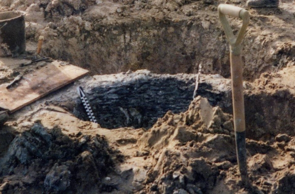
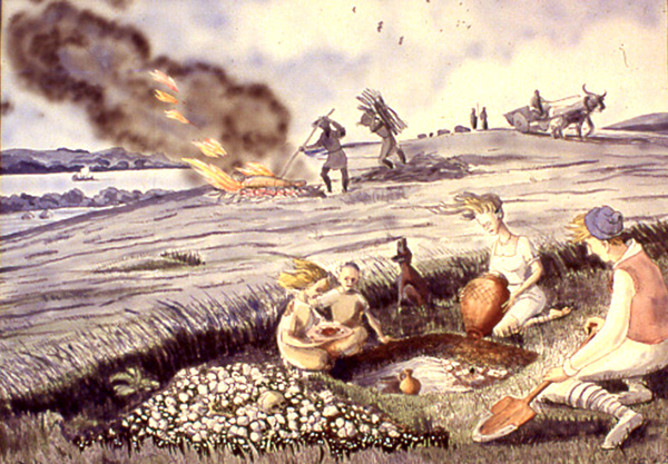
The image for Day 301 of the VM_365 project is taken from a digitised colour slide that was taken at the site at Dumpton near Broadstairs which was excavated by Joe Coy in the 1960’s. The archive from this excavation has been featured in a series of VM_365 posts, which have been looking at the detail of the finds to try to understand the significance of this unpublished site. Although the archive box for this site is labelled 1965, it appears that the dig began in 1961, when the slide archive indicates that this image was taken. The labelling of individual pottery sherds in the archive also indicates that some were recovered in a dig on the site in 1961. The picture is very important because it proves that one of the major features investigated on the site was a Roman structure, partly built in a distinctive local type of building stone used extensively in the Roman period.

Several strands of evidence have led to previous suggestions that a structure  from the Roman period was present on the site. The earliest evidence was given in Reverend John Lewis’s History of the Isle of Thanet, where it was noted that Roman coins had been found in the Dumpton area. At the time of writing in 1736, Lewis reported that a Roman wall had relatively recently been observed, but had fallen into the sea following a cliff fall. An excavation carried out by Howard Hurd on the cliff tops when new roads were being laid out on the sea front also recorded ditches and enclosures, which were predominantly of Iron Age date. A dig by the Trust for Thanet Archaeology at site near to Joe Coy’s excavation that re-examined part of Hurd’s published site, recognised that the period of occupation on the site extended well into the Roman period, much later than Hurd had suggested. One significant find in the Trust’s excavation was of a small number of fragments of distinctive Roman roof tile forms, including both Tegula and Imbrex. this evidence all pointed to the previously unrecognised presence of a building on the southern slopes of the dry valley at Dumpton gap.

Recent evidence from excavations on major Roman buildings in Thanet have suggested that all were founded on substantial Iron Age settlement sites. It is likely that prosperous Iron Age farming communities in Thanet quite quickly adopted Roman building methods and began to use imported Roman pottery alongside vessels that continued to be made in traditional pre-Roman forms and in local fabrics exhibiting various degrees of influence from the material imported from the Romanised continent.

Sadly many of Thanet’s Roman buildings have been so heavily damaged by ploughing and stone robbing that little remains of their structure but the lowest courses of walls or those lining deep recessed parts of the structures like cellars and sunken floor levels. However the presence of structured remnant of walls, built of the distinctive rounded flint cobbles is paralleled on so many sites that their presence in this image, taken with the range of finds that were associated with the excavation site, are strong evidence that another Roman building was present on the southern side of the dry valley that leads to Dumpton Gap. The topographic location of the structure is also similar to the buildings excavated at Stone Road, Broadstairs and the Abbey Farm Villa at Minster.

In today’s VM_365 image, the presence of a building is confirmed by the presence of the  line of rounded flint cobble wall which is visible running from left to right in the foreground of the image. Although the pictures have not yet been reconciled fully with the plan that was contained in the archive, it appears that the wall is part of the southern side of a rectangular  flint lined cellar, which once formed part of the structure of a building. There are striking parallels with the image and the pictures of the surviving structures found further to the north at Stone Road and on the cliff top on the northern side of Viking Bay at Fort House, Broadstairs, which have appeared in previous VM_365 posts.

It is likely that further research on the archive and re-examination of the results of the other digs in the area will bring more evidence confirming the importance of this site which spans the Iron Age and earlier part of the Roman period.


VM_365 Day 283 The North Foreland landscape

VM 283

Today’s image for Day 283 of the VM_365 project shows a complex group of cropmarks of linear and curvilinear features, stretching along the western side of the valley at North Foreland, Broadstairs. The aerial photograph were taken by the Trust in 1990 and the image faces east, looking out toward the sea. On the left hand side of the picture you can see North Foreland Lighthouse; along the sea edge is the private North Foreland estate.

Running along the west facing valley side,  the cropmark has at least six parallel linear ditches.  At the southern end of the cropmark (right of picture) several of the features take a sharp bend to the east before curving back to the same north south orientation.

The cropmarks on the chalk ridge at North Foreland have been interpreted as a multi ditched promontory fort of the Iron Age but the projection of the aerial photographic plots of the ditches on to a topographic model clearly shows them falling downhill toward the valley bottom rather than following a contour around the promontory. Recent excavations and analysis suggest that the cropmarks represent the multiple ditches of an ancient trackway, dating back at least to the Iron Age.

Excavation of sample sections through the cropmarks by the Isle of Thanet Archaeological Society in 1994 suggested that although the linear ditches originated in the Iron Age, they were recut several times and material continued to be deposited in them until the 3rd century AD (Hogwood 1995). One of the ditches on the crest of the hill was sampled and dated to the late Iron Age during excavations in 1999 and 2003 by the Trust or Thanet Archaeology. This major route seems to have extended from the coast near Kingsgate and rose through the valley to reach the ridge of Thanet’s chalk plateau, from where it led all the way to Sarre on the western side of the Island.


VM_365 Day 274 Iron Age coin Links North Foreland with continental intrigue

VM 274

The image today for Day 274 of the VM_365 project is of an Iron Age coin (a Van Arsdell Type 194), issued by Amminus, who was possibly also known as Adminius. Becoming King of the Kent’s Cantiaci tribe in the early to middle of the 1st century A.D., Amminus was thought to have had strong pro-Roman sympathies. Amminus was a son of Cunobeline, a King of the Catuvellauni in the early part of the 1st century. A gold stater minted by Cunobeline and found at St Nicholas at Wade featured in the VM_365 post for Day 272.

The coin in today’s image was found at North Foreland, on the eastern tip of the Isle of Thanet, where a large Iron Age settlement dating from the mid to Late Pre-Roman Iron Age occupied the crest of a chalk ridge overlooking the sea and an important shipping route to the mouth of the Thames estuary.

The coin links the location and its contemporary archaeology to the murky intrigue that eventually culminated in the full scale invasion of Britain by the Roman Empire. The limited contemporary evidence that is available from the distribution of coins of Amminus/Adminus is supplemented by a text reference in the biography of the Emperor Caligula produced by Roman historian Suetonius.

Seutonius claimed that Caligula had exaggerated the banishment of Amminus/Adminius and a group of followers for unknown reasons, into a grand announcement in the Senate  that the Emperor had secured victory over the whole Island of Britain.  Amminus may have also played a part in Caligula’s military posturing, which culminated in an abortive invasion of Britain. It has also been suggested that Amminus returned to Britain with the Emperor Claudius as an advisor and possible later as a Governor.

The coin issued by Amminus links the archaeology of the North Foreland, one of the major coastal Iron Age settlements in Kent, to the power struggles between the British tribal leaders and the growing Roman Empire which must have played a part in the defence of the Island against the Roman invasion fleet.


VM_365 Day 266 The barrow reconstruction drawings get more complicated

VM 266

The image for Day 266 of the VM_365 project is the second in a series of images drawn by Dave Perkins, reconstructing the sequence of event associated with a funerary monument that was revealed in excavations at Lord of the Manor, Ramsgate.

In today’s image, the single ring ditch and mound that was shown in yesterday’s picture is being renewed, ready to receive another burial. The original ring ditch and its mound, now compressed and discoloured, have been sealed under fresh chalk which is being dug from a new ring ditch with a greater diameter than the earlier one. The circuit of the new ditch is  interrupted by a causeway, where a stretch of the circuit was not excavated. It is a process like this that created the concentric circuits of ditches that show up so well in the cropmark posted on VM_365 Day 264.

The location of the barrow is closely based on the landscape of the Lord of The Manor site, with the land falling away into a deep dry valley, which is shown covered with woodland. The sweep of the valley leads to the sea at Pegwell Bay in the upper right hand side of the picture. On the left side of the image a funeral procession is making its way up the side of the valley toward the newly refurbished barrow.

It is still possible in the present day to stand near the site of the barrow and see the same view over the bay which would have been presented to the prehistoric people of the area.  It was this experience of the landscape that Dave Perkins used to draw his reconstruction images.

Further analysis of the landscape has shown that there are only a few sites in Thanet’s landscape where such an uninterrupted view is possible and it becomes clear from considering the landscape that sites were carefully chosen to provide such a panoramic view. Excavations have shown that some were used over many thousands of years to locate settlements, gather for ceremonies and to create structures where the dead could be buried.

Once again we can reconstruct the facts that are presented by the archaeological features on the ground, but can never really confirm the reasoning behind the choice of location which is so well captured in the drawing. Was it to assert a power or domination over the landscape or to enhance the visibility of the monument from other sites? Motives may have changed over time passing from willful choice into tradition whose meanings were lost in the passage of time.

The true motives are lost without the record of contemporary voices, but we can explore possible meanings through attempts at reconstruction like the drawings in this series of posts. There are questions to ask about this reconstruction: was the natural environment so open and free of the influence of man as it is shown? Was it as simple a task to create a barrow as is suggested? The ring ditches of the many barrows that have now been excavated in Thanet have demonstrated that they are often perfectly circular with regular and symmetrical profiles throughout the circuit, despite the hard chalk rock that had to be cut to create them. It is immediately possible to suggest the picture could be made more accurate with the addition of some figures carrying out some quite complex surveying and architectural control over the cutting of the ditch as well as an indication of the greater amount of labour that went into cutting away the chalk in such quantity. Our ideas progress through such criticisms of the reconstruction, which perhaps leads in the future to new images that take new ideas on board. Sadly they will not have the benefit of Dave Perkins’ wisdom and experience to inform them.

VM_365 Day 252 Crop and Soil Marks

How Crop and Soil Marks are formed illustrated by D. R. J. Perkins.

Today’s image for Day 252 of the VM_365 project is an illustrations produced by Dave Perkins to explain how crop and soil marks, indicating the presence of buried archaeological deposits, form in the growing plants in Thanet’s agricultural fields. These cropmarks are usually identified by aerial photography.

Pits or ditches that have been cut into the bedrock retain moisture in dry spells and crops planted above them grow taller and darker (A) and (a). The intensity of the cropmark vary, shallow features give only faint marks (B) and deeply buried remains can produce nothing at all (C). Buried masonry,  where there is less moisture and soil for  the crop to grow, produces a negative mark, where the crop is shorter than the surrounding area (D).

Soil marks result when ploughing brings different coloured material from ancient deposits to the surface of a field (E).

Crop and soil marks have been a valuable resource for plotting archaeological sites over very large areas of agricultural landscape, particularly in the central agricultural areas of Thanet outside the main towns. The presence of mapped cropmarks has helped to predict what archaeological features may be found before excavations have taken place. However although they have been a good indication of the scale of buried sites, excavation has often revealed considerably more detail and complexity which was not present in the cropmarks.

VM_365 Day 240 Reconstruction of Roman cremation burial at Thorne

Reconstruction of 1st century Roman cremation at Thorne

The image for Day 240 of the VM_365 project is of an artists reconstruction of the child’s grave, containing cremated remains and accessory vessels, based on one (Grave 5) excavated on a gas pipeline near Thorne, near Minster in Thanet, which was shown on Day 239. The painting is by Len Jay whose work reconstructing images from the Anglo-Saxon archaeology of Thanet, which he helped to discover, have featured in previous VM_365 posts on Day 216 and Day 217.

The image shows the rectangular pit being prepared to receive the pot containing the cremation, with the accessory vessels already in place. The grave has been excavated with a wooden shovel, strengthened by an iron blade added to the tip. On the left of the pit there is a heap of chalk from the geology that has been exposed below a thin covering of soil.   Human bones are present in the chalk, reflecting the many thousands of years that the landscape was used to create funerary monuments and the fact that successive generations often disturbed the remains of those that came before them, accidentally or deliberately.

On the left of the group of figures  surrounding the grave, a child is about to add a plate of food to accompany the vessels. Organic remains like food are something which we can not now detect through archaeology except in the rarest of circumstances, but the vessels imply that such perishable things were placed with the remains. The girl is comforted by a boy to her right and a dog howls into the air.

The burial of the cremated remains takes place on the crest of the ridge which forms the backbone of Thanet’s chalk landscape,  in the top right a sailing vessel is shown in the Wantsum channel  which is overlooked by the ridge. In the top right small figures tend a flock of sheep on the crest of the ridge. The prevailing wind that swept the open downland ridge, blowing the hair of the group to the left is still notable in the present day.

A cremation burial is simply the gathered ashes of a burnt body, that was arranged with vessels and other objects according to prevailing beliefs and sealed below a covering of soil, forming a lasting memorial to the person buried. The burning of a body is taking place in the background of this image on the crest of the ridge, using the wind to accelerate the wood fuelled fire so it could reach the temperatures that were necessary to reduce the body to ashes.

The landscape in this picture is recognisable to anyone who knows Thanet well, although it has changed considerably in recent years. However the details of the scene may reflect accurate archaeological data, it is still evocative of a distant time and of the human stories behind the objects that we recover as archaeological artefacts.

VM_365 Day 91. Underground Industrial Heritage Revealed

Tunnel Railway signOur post today for VM_365 Day 91 comes from an exciting weekend field trip by the Trust and friends to the Ramsgate Tunnels.

The letters arranged on the wall at the entrance to the chalk passage are from the sign for the Tunnel Railway, as the complex of railway lines and stations came to known.

The site combines a significant experience of the industrial archaeology heritage of the Ramsgate area, with a site associated with the defences of the coastal region in the First  and Second World War. A complex of passages, cut into the chalk to create air raid shelters for thousands of people, encircle the town of Ramsgate and the Ramsgate Tunnels experience allows a long section of the air raid shelters to be explored.

Within the tunnels is preserved the record of the many amateur urban explorers who explored the tunnels while they were closed to general public access. The names, slogans and dates scribbled and painted on the walls show how the Ramsgate tunnels remained in the consciousness of local people, their fascinating history waiting to be brought to life as a very popular public attraction.

VM_365 Day 65 When is a coast not a coast? Beware of the changing landscape.

Bronze Age pit lined with woven timbers

For Day 65 of VM_365 the image shows one of the most important sites in Thanet for understanding how the changing landscape can throw up problems for archaeologists when they are interpreting features and finds in the landscape.

In the centre of the picture is a pit under excavation on the foreshore at St. Mildred’s Bay on the north coast of Thanet. Against the back edge  of the pit can be seen the thin  horizontal and vertical timber rods that form a woven lining to the pit, similar to a woven basket closely fitting the size of the pit.

In the dry chalk landscape of Thanet, pits and other features of this age are generally filled with sequences of chalky soils or clay and silt deposits, with no hint that any organic deposits ever existed. In other parts of the country where archaeological features have been found in waterlogged conditions, many examples of the use of organic materials and even complicated carpentry from sites of the same date have been recovered. Because the conditions in Thanet are not good for preserving organic material, all trace of this part of the record has been erased.

If recording is carried out with care and attention, archaeologists can deduce that such material may once have been present, lining pits and forming structures that are now undetectable apart from the holes that were dug for them or the material that eventually replaced the organic deposits. The positive aspect of the discovery of sites on the foreshore in waterlogged conditions has demonstrated that the absence of this material elsewhere is due to the conditions of preservation not the absence of this material in the period.

The negative aspect is the interpretation of the location of these sites at the time they were created. Thanet’s land mass has been diminishing year after year as rising sea levels have covered land and the sea  has eaten away the chalk to form the cliff line and the flat platforms of the foreshore. Sites like the one in today’s image were not on the coast when they were created, they may even have been some distance away from the coast and we must be careful not to give an undue significance to the present coastal location of the sites when they had no bearing on the settlement at the time.

It was a matter of good luck that some archaeological features were preserved  in the platform cut by the waves around the coast, leaving remnants behind in waterlogged conditions to give us an idea of what life was like on dry land four or five thousand years ago. It is clear from evidence like this that the study of the dynamic landscape and attempts to understand and represent the changes on maps are an important part of the archaeologists tools for interpreting past societies.


VM_365 Day 63 Archaeology in a Landscape

Bronze-Age round barrow on hilltop overlooking Pegwell Bay

How does an archaeological site reflect its landscape? This image for VM_365 Day 63 shows how important location within a landscape is for the choices that are made on where to live, work and celebrate.

Bronze Age round barrows like this one at Ramsgate were formed by digging a circular ditch into the hard chalk of the hillside to create a mound in the centre from the spoil from the ditch. Very frequently, but not in every case, the central mound covered the burial of an individual which was itself laid in a chamber created by cutting a rectangular pit into the chalk.

But what motivated the choice for the location of each round barrow? This image contains one answer to this question in the vista over Pegwell Bay which can be seen  beyond the section of the ditch revealed in the trench. From this position the land from Deal,  the  eastern mouth of the Stour and the mouth of the valley  of the Wantsum, sweeping through to the northern side of Pegwell Bay where the open sea was visible beyond the land.  On a clear day the cliffs on the coast of France can also be seen on the horizon from this location.

In general, similar Bronze Age funerary monuments in Thanet have been found in commanding locations on the convex slopes of hillsides and valleys which the undulating chalk downs of Thanet  possess in abundance. In each location the commanding view demonstrates that the position was carefully chosen and surveyed to assess the suitability of the site.

Before we interpret the motives behind such choices of position, we need to consider  that the landscape has changed from that of the Bronze Age through coastal erosion and sea level rises. The Bronze Age barrow burial rite also lasted some centuries and within the monuments recorded we need to consider what influence the  choices of earlier people had as time passed.

Many of the best sites may have been taken at an early stage, or perhaps the best locations were identified and rationed in some way that was determined by the culture and contemporary ideas of rights and status. To date there has been little evidence that barrows were partially overlapped to usurp the space taken by an earlier monument, although we do have evidence that the ditch of an earlier barrow was re-excavated and trimmed, possibly to accommodate a new burial. Perhaps it was acceptable to re-use a barrow, respecting and associating a new person with the personality and status of the earlier burial,  but it was not acceptable to damage an earlier barrow and erase the memory of the significance of the earlier burial.

The landscape seems to have had a deep resonance in the culture of Bronze Age Thanet, although we can only work out the ways these were turned into cultural forms by reasoning from our data on the location of features within the landscape and considering the logic of the placement of the sites within the space and land forms that were available. In short, archaeology loses an important dimension if context within its landscape does not form part of the archaeological investigation that is applied to it.

VM_365 Day 62 The shape of the land shapes the culture

Topographic map of the Isle of Thanet
The distinctive landforms that shape Thanet’s history

The map shown here for VM_365 Day 62 is of the underlying shape of the landcape of the Isle of Thanet, a factor which has shaped its history and culture over many centuries.

The shaded relief of the map was created using height data taken by the NASA space shuttle as it orbited the earth. Unlike yesterdays image which showed the locations of all the discoveries of archaeological remains from a particular  historical era, the Roman period, this map shows the enduring structures of the Isle of Thanet’s landscape.

Modern development has sometimes disguised the natural shapes of the chalky slopes and valleys that divide up the space that has been occupied in Thanet for over six thousand years, but with careful observation you can still recognise its major features, although less so as new housing estates and roads change the natural rhythms of the landscape each year.

If you are out and about on the Isle, look around and see how the land rises and falls and in places gives amazing views over the slopes and to the sea.  Observe how the various towns and areas occupy particular slopes or are separated by valleys.  Follow the routes of the Islands older roads over the ridges and up the slopes of the network of valleys that underpin the landscape.

The ancient inhabitants of Thanet were acutely aware of the shape of their landscape and chose the sites of their settlements, ceremonial sites and burial grounds with their location on specific landscape features in mind. Lines of sight between locations were important, as were vistas where large distances could be see all around. Access to resources or to the sea and the flat grounds at the top of the hill shaped the way the Island’s people moved around. Sometimes the relative effort of getting from one place to another dictated the way settlements grew up around the area.

To understand the distribution of sites in one particular period we need to understand that the one relatively constant factor in the development of  society over time was the influence of the physical shape of the land. Understanding the shape of the land can explain the choices made when settling the landscape as well as the changes that happened over time.