Category Archives: VM_365 Project

VM_365 Day 36 First World War Structures at Stonar


VM_36

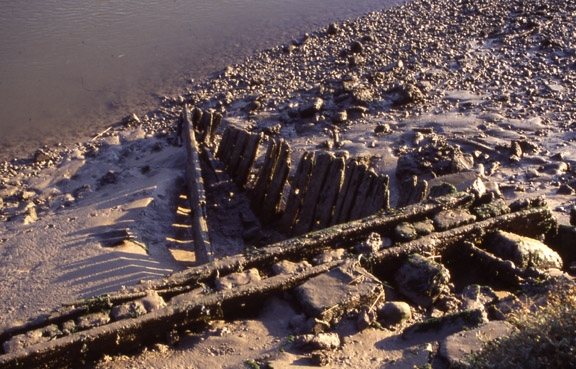
To commemorate the 100th anniversary of the start of the First World War, today’s image is of the timber structures at recorded at Stonar Cut, Richborough in 2005.

One of the least known structures of World War I is the Stonar Port, constructed between 1916-1918 to supply the Front Line in France and Belgium using the French canal network. Today only the upright timbers of the once extensive wharves survive to be seen in the water line along the River Stour.

Along with the structures that were added in the Second World War, this port  and the many thousands of people who served their country in the two wars are not well known outside the military history field.

Find out more about our survey carried out in 2005 in the Virtual Museum.

Further reading:

Butler, R. 1999. Richborough Port. Pfizer Ltd. Sandwich

r-port_book

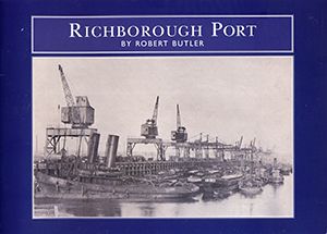
We have a very limited amount of these publications for sale. If you wish to purchase a copy for £5.00 plus £2.00 p&p (UK only) leave a comment and we will get back to you to arrange payment.

Update: You can now order this book from our Publications page


VM_365 Day 35 Anglo Saxon Bronze Key

VM 35

Today’s image is of a Bronze key once again from the Anglo Saxon cemetery at Sarre, also found in grave 286, like the glass beads shown yesterday.

The key is made of copper alloy or bronze and is beautifully preserved. It was found in association with a bronze handle and some sheet bronze fragments which may be the remnants of a casket with its key that were placed in the grave alongside the body.


VM_365 Day 34 Anglo Saxon Glass Beads

Following on from yesterday’s image of the gold thread  in grave 285 from Sarre, today’s image is of 29 glass beads found in grave 286 from the same Anglo Saxon cemetery site.


VM 34

The grave was large  and well cut, most likely containing a female, based on the objects within it. Like grave 285 it had been disturbed in antiquity, skeletal material and objects  left behind by the robbers were scattered throughout the grave fill.

Among the objects found within the grave were nine amber beads and thirty one glass beads. Twenty nine of the glass beads are shown in the picture above, all are coloured glass. The one at the top left hand corner is a multi coloured or polychrome bead, almost globular in shape and of yellow glass with brown crossing trails. The other beads range in shape from pentagonal cylinders, 4 sided cylinders, short cylinders, discs and one is pear shaped.

Find out more about the site by reading:

Brent, J. 1866. Account of the Societies Researches in the Saxon Cemetery at Sarr. Part 2 Archaeologia Cantiana VI, 157-85

Brent, J. 1863 . Account of the Societies Researches in the Saxon Cemetery at Sarr. Archaeologia Cantiana V, 305-22

Perkins, D. R. J. 1991. The Jutish Cemetery at Sarre Revisted: A Rescue Evaluation.  Archaeologia Cantiana CIX, 139-162

Perkins, D. R. J. 1992. The Jutish Cemetery at Sarre Revisited; Part II. Archaeologia Cantiana CX, 83-120

For more on the clothing of the Anglo Saxon period read Penelope Walton Rogers’ excellently researched and illustrated book:

Walton Rogers, P.  2007. Cloth and Clothing in Early Anglo-Saxon England. CBA Research Report 145, Council for British Archaeology: York.

VM_365 Day 33 Gold threads

Today’s image is of a fragment of gold thread found in a mid to late sixth century grave at Sarre in 1990. The grave of an adult, probably a female, was disturbed in antiquity with the whole of the grave being emptied and backfilled.

VM_33
The  thread measures approximatley 20mm long and has been cut from a gold foil sheet that was 96.595% pure. The strip was folded and used in a brocaded pattern with textile threads, probably worn in a head band across the brow or decorating the edge of a coif or hood. The band was tablet woven and the pattern was inserted during weaving, not embroidered afterwards; the impressions of the textile threads can be clearly seen on the gold thread.
Similar gold threads have been found in Kentish graves of a similar date at Monkton, Bifrons, Lyminge and Faversham and are probably of continental origin.

Find out more about the site by reading:

Brent, J. 1866. Account of the Societies Researches in the Saxon Cemetery at Sarr. Part 2 Archaeologia Cantiana VI, 157-85

Brent, J. 1863 . Account of the Societies Researches in the Saxon Cemetery at Sarr. Archaeologia Cantiana V, 305-22

Perkins, D. R. J. 1991. The Jutish Cemetery at Sarre Revisted: A Rescue Evaluation.  Archaeologia Cantiana CIX, 139-162

For more on the clothing of the Anglo Saxon period read Penelope Walton Rogers’ excellently researched and illustrated book:

Walton Rogers, P.  2007. Cloth and Clothing in Early Anglo-Saxon England. CBA Research Report 145, Council for British Archaeology: York.


VM_365 Day 32 Pottery from a period of change – Iron Age people become Romans

Locally made pottery Jar, encapsulating the transition from Iron Age to Roman culture

Today’s image for Day 32 of the  VM 365 project is of a pottery vessel dating from an interesting period in history which is well represented in Thanet’s archaeological record, the later stages of the Roman conquest of Britain (50-75/100 AD).

Dating from a period when Late Iron Age pottery traditions were giving way to new Romanising production techniques, this near complete jar in a pottery fabric known as Thanet silty ware is decorated with raised beads and a chevron pattern around the upper part of the body. This particular vessel dates no later than 60-75 AD, a couple of decades after Britain was invaded and occupied by Roman forces.

The jar was recovered from the fill of a pit (cut 216) at an excavation at a site in Sea Parade, Birchington, it  survived almost intact with only one large crack in the body of the jar and some damage to the rim. Characteristically for this type of vessel it has been deliberately made with three holes in the base, much like a modern flowerpot.

The many complete or near complete vessels of this period that have been recovered in excavations carried out at Minnis bay, particularly those of Antoinette Powell-Cotton in the 1950’s and 1960’s. The pottery sherds and vessels from these sites  have been the foundation for classification and dating this important sequence of  pottery, which spans a time of major cultural change.


VM_365 Day 30 The purpose of pondering prehistory?

Image of burial inserted into ditch of an Early Bronze Age round barrow
Can we find out who this person buried in the ditch of a round barrow was?

What drives our interest in following the trail of evidence from aerial photographs to the archaeology in ground that has been shown in the VM 365 images over the last few days?

The image for Day 30 of the VM 365 project shows a human skeleton, a young adult that was buried in a small grave that was excavated into the terminal of the round barrow that was shown in yesterday’s image. The grave fill overlying the skeleton was covered with a large fragment of whale rib.

Rather than focus on the excitement of the excavation process that revealed this burial, we should pay attention to the motivation for carrying out the investigation which is often overwhelmed by the excitement about the external character of the results.

The fundamental reason for developing the methods of archaeological investigation was, and remains, curiosity about the places we live in and about the people who have occupied the same places in the past. There are no written records describing the circumstances and experiences of life in periods such as the Bronze Age which are represented in such abundance in the Isle of Thanet. There is no evidence that emanates from their direct experience, which could be used to reconstruct their lives. The people under investigation in these circumstances are truly pre-historic, we lack any tools but archaeological methods to generate knowledge about them and to create narratives of the events that affected them.

Our interest in the universal set of questions, who, where, what, why, and when will not rest for lack of easy evidence and careful exploration and analysis can be used to describe the circumstances of discovery in ever greater detail. Once we understand as much as we can about the circumstances of discovery, and describe them with as much precision as possible, we can begin to interpret the meaning of the things we have discovered. Archaeological investigation must also be used to established the limits of our knowledge. If we take careful note of the present conditions of our discoveries we can begin to understand that many things that are lost from the image of the past we can generate.

Archaeology is about exploring the deliberate construction of messages by people in the past, the signal, as well as the inadvertent or deliberate destructive processes that can distort part of the message, the noise. To produce good and thoughtful interpretation; assumptions should be questioned; different perspectives  adopted on the data and our ideas subjected to critical review.

There is always something new to said and new information that can be gathered from the evidence collected by archaeologists. In the case of this burial, its inclusion in a research programme investigating Isotopic data that can be extracted from the teeth will in due course add more to the constellation of knowledge that gathers around the physical remains we recover from excavations.


VM_365 Day 29 What lies beneath the cropmark rings?

Circular ditch at North Foreland, Broadstairs showing in chalk geology after plough soil has been removed.

We know from the image in Day 28 of VM_365 that the locations of  the prehistoric burial mounds of Neolithic and Bronze Age Thanet can still be traced from the influence they have on the growth of the crops in the fields that lie over them.

Today’s image, taken at a site at North Foreland near Broadstairs, shows what happens when the thin skim of plough soil that overlies the ditches is removed by archaeologists, using a combination of a carefully controlled mechanical excavator and a final clean up using hand tools.

Once the earth filled ditches and pits underlying the plough soil has been exposed, planning and recording can take place before any further excavation is carried out to examine how deep the surviving ditches may be, and to recover any finds that can help to give a date for the feature.

Careful attention is paid to the irregular patches of dark soil that are enclosed within the ditch because these may be contain the burials that were marked by the ring ditches and their associated mounds as enduring features in the landscape . Other burials were often inserted later, when the mound and ditch surrounding the burial had become a familiar feature in the landscape.

At this stage an archaeological site which was previously known only through images holds the potential to produce physical evidence for the past.

VM_365 Day 28 Seeing the Bronze Age past beneath the soil

VM 28

Another image today from our slide archive taken in the early 1990’s, showing how we know so much about the past of the Isle of Thanet without even touching the ground.

The image  shows the cropmarks of two ring ditches, located in the fields behind Margate cemetery and council tip. These cropmarks undoubtedly represent the enclosures of unexplored Bronze Age burial mounds, just two of many hundreds of such features that are known to exist on the Isle of Thanet and have been identified in aerial photographs.

Many unsubstantiated ideas have accumulated around the huge number of these ring ditch cropmarks and the prestigious burials they represent, including a spurious association with Procopius’s ‘Island of the Dead‘ legend. However, their frequency and survival in the landscape undoubtedly contributed to the name that was given to Thanet as a territory in the early political divisions of Kent.

In the Domesday survey of the 11th century, the Isle of Thanet constituted  a ‘Hundred’, a collection of a hundred smaller divisions of plough land called hydes. Known as the ‘Hundred of Ringslow’, the Hundred of ‘ring-mounds’, the name shows that the Bronze-Age past of the Isle had a lasting influence on the area.

VM_365 Day 27: Down to Margate Pier

VM 27Our image today shows that Archaeology doesn’t have to  be buried in the ground, or to be  ancient, to reveal an important story of the past.

In celebration of the recent long spell of warm summer weather, we want to show that one of Thanet’s important seaside landmarks Margate Pier preserves much archaeological evidence of its us for industry and pleasure over the last 200 years.

Just look carefully for the fixtures and fittings that demonstrate that there were once many different uses for the pier, all related to Margate’s rich and diverse history. Even the stones of the pier tell a story, they were quarried at Aislaby in North Yorkshire.

If you can get down to Margate Pier this weekend, see if you can identify any of these or any other clues to the pier’s past history:

The picture shows clockwise from top left:

1. Metal crane track, used from the late 19th and early 20th for coal deliveries to the Margate Gas works

2. Scars of the tracks off the miniature railway that ran along the promenade in the 1950’s and 60’s

3. The original quoin stone and pier surface dating from the c. 1840’s at the landward side of the pier near the Turner Contemporary. This has been covered by later structures.

4.  Mooring positions inscribed into the edging stones along the inner harbour c. mid 20th century. NCB  probably stands for the National Coal Board.

There’s more information about Margate Pier in the Virtual Museum pages about our survey of the structure that was carried out in 2005, for the earlier design of the Turner contemporary – if anyone remembers that!

Let us know what you find if you visit the pier this weekend.