Return to Gallery
Display Contents
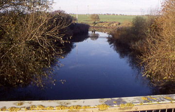
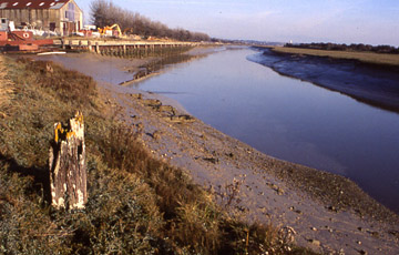
Stonar Cut 1900 - 2006
The Stour and the River Wantsum represent the remains of the wide channel which once divided Thanet from mainland Kent known as the Wantsum Channel. Stonar cut is located within the Wantsum Channel.
The Stour and the River Wantsum
represent the remains of the
wide
channel which once divided Thanet from mainland Kent known as the
Wantsum Channel. Stonar cut is located within the Wantsum Channel.
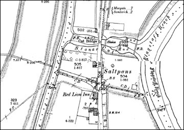
The Cut was constructed in 1776 following an Act of Parliament passed on the 29th November 1774. It was constructed near the site of a Salt Works making use of an existing sluice. The cut was constructed as a flood relief mechanism for drainage of what was known as the general valleys which is the watershed of both sides of the Wantsum Channel.
The features recorded in the survey appear to date to the establishment of the Richborough Port and associated facilities between 1916 and 1918. Extensive structural works were carried out near Stonar Cut during the First World War.
The existing sluice system recorded may
date to that period but has
been adapted in more recent times to use an electric motorised system.
Remnants of retaining walls and timber pile structures consolidating
the banks were observed in addition to debris from the recent
redevelopment of the area.
The road bridge and sluice structure are late 20th Century constructions, broadly located on post First World War predecessors. The timber structures and retaining walls are harder to date. The timbers are very similar to the piled structures erected on the foreshore along Flagstaff reach and in the timber wharf. The materials are also similar but less complex than the remnants of Richborough Wharf that exist north of the cut.
The road bridge and sluice structure are late 20th Century constructions, broadly located on post First World War predecessors. The timber structures and retaining walls are harder to date. The timbers are very similar to the piled structures erected on the foreshore along Flagstaff reach and in the timber wharf. The materials are also similar but less complex than the remnants of Richborough Wharf that exist north of the cut.
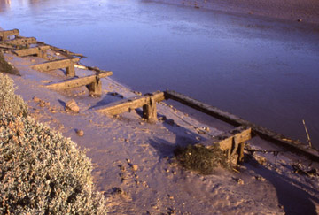
It is most likely that the timber piles were driven into the bank to consolidate the edges and that the wall was subsequently built against the face of the piles. The thrust of the creeping bank against the piles has destroyed both the pile walls and the facing brick wall. A close examination of the 1:2500 Ordnance Survey maps of 1896 and 1938 provides some evidence of the date of the structure. The 1896 map appears to show an unconsolidated bank with earth bunds providing defence against flooding on the upper levels of the bank
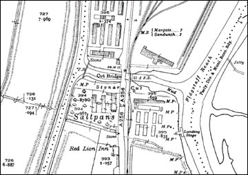
In the years after the Second World War the infrastructure of Richborough port declined. The structures either side of the cut have been demolished and a new warehouse unit constructed on the north side.
A bridge for the East Kent Light
Railway, sluice and
footbridge were
added to the east of the road bridge. This suggests that the existing
banks were consolidated and structured using the driven pile structure
faced with a brick retaining wall. It is likely that these improvements
were carried out by the Royal Engineers during the general construction
work for the establishment of Richborough port between 1915 and 1918
and perhaps specifically the construction of the new wharf in 1916. It
is possible that the sluice gates in part date from that period with
the electric motors powering the gates being added in the latter part
of the 20th Century.
In the years after the Second World War the infrastructure of Richborough port declined. The structures either side of the cut have been demolished and a new warehouse unit constructed on the north side.
In the years after the Second World War the infrastructure of Richborough port declined. The structures either side of the cut have been demolished and a new warehouse unit constructed on the north side.
A bridge for the East Kent Light
Railway, sluice and footbridge were
added to the east of the road bridge. This suggests that the existing
banks were consolidated and structured using the driven pile structure
faced with a brick retaining wall.
It is likely that these improvements were carried out by the Royal Engineers during the general construction work for the establishment of Richborough port between 1915 and 1918 and perhaps specifically the construction of the new wharf in 1916. It is possible that the sluice gates in part date from that period with the electric motors powering the gates being added in the latter part of the 20th Century.
In the years after the Second World War the infrastructure of Richborough port declined. The structures either side of the cut have been demolished and a new warehouse unit constructed on the north side.
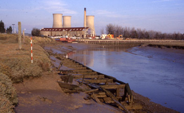
With the loss of Richborough Power station constructed in the 1960’s and a number of other factories and industrial units, combined with the general economic decline of the Pegwell bay area with the loss of a Hover Port also established in the 1960’s and closed in the 1990’s, much of the port has been eroded by the river and reclaimed by nature, little remains to demonstrate the enormous output of the port in the years of the First and Second World Wars.
It is likely that these improvements were carried out by the Royal Engineers during the general construction work for the establishment of Richborough port between 1915 and 1918 and perhaps specifically the construction of the new wharf in 1916. It is possible that the sluice gates in part date from that period with the electric motors powering the gates being added in the latter part of the 20th Century.
In the years after the Second World War the infrastructure of Richborough port declined. The structures either side of the cut have been demolished and a new warehouse unit constructed on the north side.
With the loss of Richborough Power station constructed in the 1960’s and a number of other factories and industrial units, combined with the general economic decline of the Pegwell bay area with the loss of a Hover Port also established in the 1960’s and closed in the 1990’s, much of the port has been eroded by the river and reclaimed by nature, little remains to demonstrate the enormous output of the port in the years of the First and Second World Wars.
It is a product of secrecy with which the Richborough port was established that the implications of the port to the history of the development of mechanised cross channel freight operations are not widely known. The standing structures at the Stonar Cut, which all appear to date from this period, reflect the scale and transformative power of such an undertaking.
References and Further Reading
Butler, R. 1999. Richborough Port. Pfizer Ltd, Sandwich.
Chamberlain, D. M. 198?. The Ancient Town and Port of Stonar. East Kent Maritime Trust.
Hardman, F. W. and Stebbing, W. P. D. 1940. Stonar and the Wantsum Channel. Part I – Physiographical. In Archaeologia Cantiana Volume LIII pp 62-80.
Version 1. Posted 28.02.06
All
content © Trust for Thanet Archaeology