Monthly Archives: April 2015

VM_365 Day 285 Bronze Age Roundbarrow?

VM 285

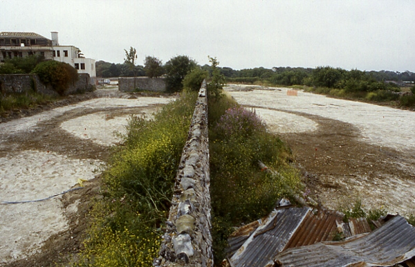
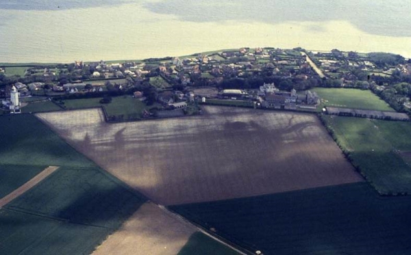
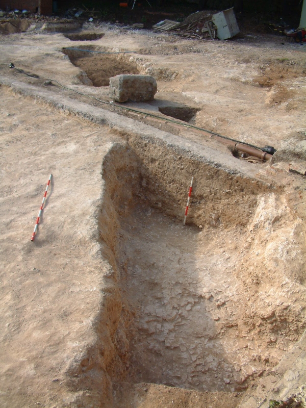
The image for Day 285 of the VM_365 project shows one of the three ring ditches that were excavated in 1999 at the St Stephens College site, at North Foreland, Broadstairs. The cropmarks extending along the valley side (to the right of this image) were shown on Day 283 and an overview of another of the barrows, an Iron Age enclosure and storage pits (located in the area at the top of this picture) were shown on Day 284 of the VM_365 project.

Two sections of this ring ditch, which are assumed to be a continuous circuit, were exposed on either side of a standing flint wall, which is part of an early 19th century Grade II listed structure and was left in place. No internal graves were found which could confirm that the ring ditch was a round barrow, but as the central part of the feature was obscured by the wall and an unexcavated area either side of it, a central grave could perhaps exist there.

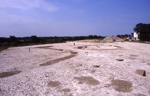
The ring ditch measured 21m in diameter was formed of a series of  fairly straight cuts, each roughly 2.5m in length, which intersected at acute angles to form a ring. The profile of the ditch was fairly consistent measuring 0.74 metres deep with steep, approximately 60° edges and a flat base. The fills of the ditch did not indicate any bias in the direction of filling  to suggest the presence or composition of a central mound enclosed by the ditch.

Pottery of Early Iron Age date was found in the uppermost fills of the ditch, which were presumably incorporated when the ring ditch was almost entirely filled and the major Iron Age settlement was established to the south in the early 6th century BC, replacing the Bronze Age pattern of landscape use for funerary monuments with a  hill top village.


VM_365 Day 284 Excavation of a Prehistoric site at North Foreland, Broadstairs

VM 284

The image for Day 284 of the VM_365 project shows archaeological excavations in progress in 1999, at the site of St Stephen’s College, at North Foreland, Broadstairs. The view in this picture faces north west toward the mouth of the Thames Estuary, although the sea is hidden behind the range of trees at the top of the picture.

The  St Stephen’s College dig site is located just to the east of the cropmark group at North Foreland that was shown in yesterday’s image for VM_365 Day 283. One of the ditches that shows in the cropmark extended into the site.

The wide range of features found on the site are all represented in the picture. On the top, right hand side is the ring ditch of one of three Bronze Age round barrows excavated on the site. This barrow contained three burials, a large rectangular central grave cut and a second, smaller, oval grave cut on the northern side of the Barrow. A second burial had been inserted in the upper fill of that grave. The circuit of the barrow ditch had been recut in the Iron Age, possibly to form a hut platform.

On the left side of the picture you can see the ditches of an enclosure, dating to the Middle Iron Age. An  entrance causeway formed by a break in the ditch circuit can be seen at the front. Some of the ditches that branch to the top of the hill from the trackway that can be seen in the cropmarks on the hillside lead directly to the rectangular encloure.  At least six structures built with four timber posts were enclosed within the rounded rectangular ditch, although these could be from a different phase of the settlement when the ditch was no longer visible.

The group of storage pits visible in the foreground, close to the entrance of the enclosure, were dug over a period of time spanning the Middle to Late Iron Age.  One of the storage pits located in another part of the site, not shown in the image,  was reused for a burial which featured in a sequence of VM_365 posts on Day 123, Day 43 and Day 113. Iron Age objects found in some of the pits excavated on the St. Stephen’s site including Bridle bits, a bone handle, loom weights and evidence for chalk plastered structures have also been posted as part of the VM_365 project.

The tiny figure present in the middle of the enclosure is the Trust’s first Director Dr Dave Perkins who led the excavations in 1999.


VM_365 Day 283 The North Foreland landscape

VM 283

Today’s image for Day 283 of the VM_365 project shows a complex group of cropmarks of linear and curvilinear features, stretching along the western side of the valley at North Foreland, Broadstairs. The aerial photograph were taken by the Trust in 1990 and the image faces east, looking out toward the sea. On the left hand side of the picture you can see North Foreland Lighthouse; along the sea edge is the private North Foreland estate.

Running along the west facing valley side,  the cropmark has at least six parallel linear ditches.  At the southern end of the cropmark (right of picture) several of the features take a sharp bend to the east before curving back to the same north south orientation.

The cropmarks on the chalk ridge at North Foreland have been interpreted as a multi ditched promontory fort of the Iron Age but the projection of the aerial photographic plots of the ditches on to a topographic model clearly shows them falling downhill toward the valley bottom rather than following a contour around the promontory. Recent excavations and analysis suggest that the cropmarks represent the multiple ditches of an ancient trackway, dating back at least to the Iron Age.

Excavation of sample sections through the cropmarks by the Isle of Thanet Archaeological Society in 1994 suggested that although the linear ditches originated in the Iron Age, they were recut several times and material continued to be deposited in them until the 3rd century AD (Hogwood 1995). One of the ditches on the crest of the hill was sampled and dated to the late Iron Age during excavations in 1999 and 2003 by the Trust or Thanet Archaeology. This major route seems to have extended from the coast near Kingsgate and rose through the valley to reach the ridge of Thanet’s chalk plateau, from where it led all the way to Sarre on the western side of the Island.


VM_365 Day 282 Old meets new at Pegwell

VM 282

Today’s image for Day 282 of the VM_365 project shows the segment of a Neolithic causewayed enclosure that was excavated in 2007 at Courtstairs, near Pegwell Bay. What is interesting in this picture is that you can see human activity on the site spanning a period of over 5500 years.

The earliest element is the linear cut of the Neolithic causewayed enclosure, formed by the excvavation of a continuous curving line of conjoined pits. The fills of the individual cuts containing pottery sherds shown on Day 172 including some from a round based vessel shown on Day 187; finely worked flint blades and bladlets shown on Day 171 and a flint sickle that was featured on Day 173, as well as animal bone, mainly representing large cattle species.  A cow skull that featured on Day 186 was found at the base of one of the pits forming the enclosure and was carbon dated to 3636-3625 cal. BC.

Jump forward over 5000 years and you can see the concrete footing for a building that most recently occupied the site, its foundations cutting the fills of the Neolithic enclosure.  Alongside the linear concrete foundation was a drainage trench containing a modern drain and an electricity cable. In the background you can see the blue plastic pipe supplying mains water to a nearby building.

Until the early 19th century the Isle of Thanet was sparsely populated and had little development on the rolling chalk hilltops overlooking the coast, which may have attracted the Neolithic settlers to the site. The explosion of seaside suburban development has hidden many of our most significant prehistoric sites under the foundations and gardens of Thanet’s coastal towns. On rare occasions archaeologists are able to uncover some of these sites for investigation.


VM_365 Day 281 Roman Spoon-Probe

VM 281The image for Day 281 of the VM_365 project shows a copper alloy cast Roman Spoon-Probe  found during the 1999 excavation season of the Roman villa at Minster.
This alarmingly named object would originally have been double ended, with a spoon at one end and a probe at the other. The spoon end of this example has broken off. The shaft of the instrument has been cast with barley sugar twisting.
These instruments were multi-purpose, the spoon end would have been used to extract cosmetics from containers and the probe end used to apply them to the face, possibly also to mix them too. The probe could have been used rather like a cotton wool bud if wrapped in wool or cloth to remove the cosmetics from the face. These instruments were also used medically for the application of medicines to the ears and eyes as well as being used to excise and clean wounds.

VM_365 Day 280 Roman Brooch from Monkton

VM 280
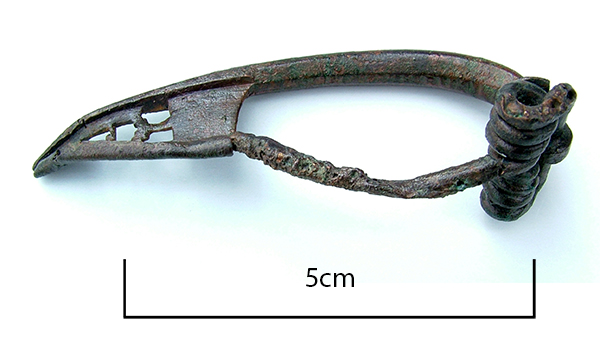
The image for Day 280 of the VM_365 project shows a Bow Brooch or Fibula of late Iron Age or Early Roman date, which was found in 1992 when trial trenching was carried out between Monkton and Minster in advance of the expansion of the old single lane road into a dual carriageway.

The Bow Brooch is made from copper alloy and has a perforated catch plate to cover and secure the pin. Classified as an early Colchester type, it dates to the period between 25 BC and 50-75 AD.

Like many clothes fastenings and small personal items, Bow Brooches like this formed part of the Late Iron Age costume and continued to be worn into the Early Roman period, despite the many material changes the Roman invasion brought to the country. Because of the continuing influence of indigenous costume and the fastenings and ornaments that were associated with them, a distinctive Romano-British hybrid culture eventually emerged, drawing on elements from both cultures.

VM_365 Day 279 Anglo Saxon Bronze Object

VM 279
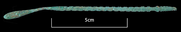
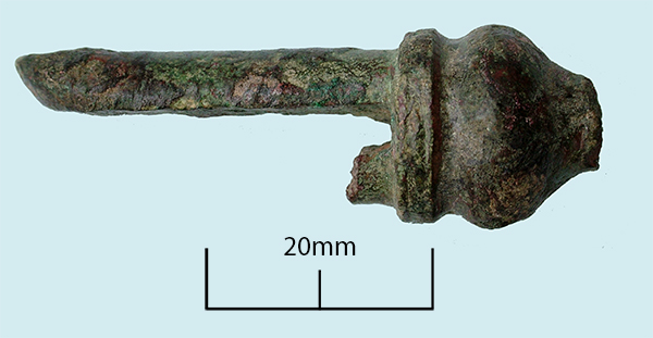
Today’s image for Day 279 of the VM_365 project is of a copper alloy object that was excavated during evaluations at Ebbsfleet, Thanet in 1990.

Made of copper alloy or bronze in a mould, the object has broken above the rounded tip and would originally have had two projections on the underside – one now broken. The surviving projection originally had a hole pierced through it, which would have been mirrored by the one on the other side. This hole has been filled by the remains of a bronze rivet which was used to fasten something between the two projections.

A similar object was excavated from grave 116 at the Anglo Saxon cemetery at Buckland, Dover. The Buckland object is more complete than our example and included a hanging loop at the top which connected to a bronze girdle hanger by a thick wire loop. Evison suggests that bronze rivets would have fastened the peg-like projections to a wooden shaft which could have been anything from a weaving implement to a holder for a hone stone.

Reference

Evison, V. I. 1987. Dover: Buckland Anglo Saxon Cemetery. HBMC Archaeological Report no. 3. pp 117, 242 & 320.

VM_365 Day 278 Medieval knife

VM 278
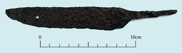
The image for Day 278 of the VM_365 project is of a medieval iron knife found in a layer of medieval occupation debris including 13th to 14th century pottery sherds found in investigations carried out during road improvements between St Nicholas at Wade and Monkton in Thanet between 1990 and 1991.

The knife has a whittle tang which means that a wooden handle would have been knocked over the tang, rather than having a two piece handle rivetted onto a wide tang, an innovation that became more popular from the mid medieval period onwards.

This was an all purpose knife that could be used for eating, working and for defence and was a development from the Anglo Saxon scramasax, probably carried in a leather sheath at the waist.


VM_365 Day 277 Anglo Saxon Bone awl

VM 277
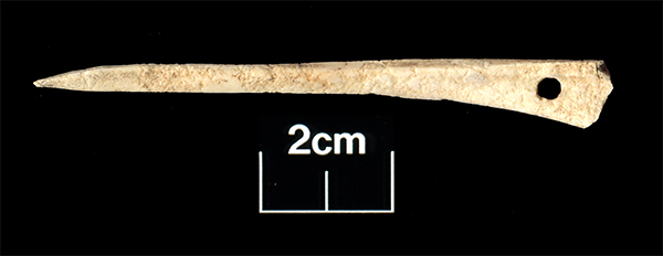
The image for Day 277 of the VM_365 project shows a bone awl found in a late 8th-9th century pit at Westgate during excavations in 2006.

At first glance this object is very similar to an Iron Age cloak pin that accompanied a burial in a pit at Dumpton. However, when you look closely at this artefact you can see that it has been carved from a much lighter weight bone from a large bird, possiby a duck, and the end has been purposely carved to a fine, sharp point rather than a rounded end as the cloak pin has been. The awl is also flat on either side rather than having a rounded profile.

So what would the awl have been used for? It would seem likely that this would have been made for piercing holes in hides or leather, perhaps for making shoes, bags and pouches. The flattened profile would allow the user more purchase when turning the awl to create a hole in a hide. The hole pierced through the end of  the awl was probably used to attach the awl to a belt or perhaps to allow it to be hung up so that it was easily to hand while working leather.

Another object used in the manufacture of cloth have also been found on the site, a beautifully carved and well used pin beater featured on Day 144 of the VM_365 project.

VM_365 Day 276 Recycled pottery spindle whorl

VM 276

Today’s image for Day 276 of the VM_365 project shows two sides of a ceramic spindle whorl that was found during excavations at Minster, Thanet in 1990.

This Roman spindle whorl  has been recycled from a sherd of a flagon dating to the second half of the 1st century A.D. The pottery sherd has been carefully shaped into a disc and a hole pierced through the centre. The disc is slightly curved, rather than flat, following the  original profile of the flagon. In the picture on the left, marks left from turning the flagon on a potters wheel can clearly be seen as stripes in the fabric.

Other objects associated with weaving including spindle whorls of Iron Age and Late Iron Age/Early Roman date, as well as Iron Age loom weights and an Iron Age weaving comb have previously featured in the VM_365 project