Category Archives: From the Archives

VM_365 Day 49 Rough treatment for Early Iron Age pottery sherds

Early Iron Age pottery sherds from South Dumpton Down with rusticated surface treatment

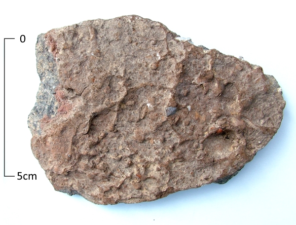
The bizarre effects of a surface treatment that as applied to some pottery in the Early Iron Age (600 – 400BC) are illustrated in todays VM_365 image of a sherd from the Iron Age settlement at South Dumpton Down, Broadstairs.

Additional clay was added to the surface of the pots while they were being made, which was wet enough for the potters hands to raise these irrregular lumps and bumps on the outside of the vessels. Sometimes broad wiping marks or and other visble signs of the potters hands can be detected in the surface pattern.

It is not known why this process was applied to certain vessels,  but it is thought it may have made the vessels easier to grip if they were perhaps used in activities that would otherwise have made the surfaces slippery. A suite of vessels has been identified in east Kent which have had this ‘rustication’ effect applied to their surfaces, examples are also known from the continent.

The method of roughening the surfaces of the vessels was commonly used in the early Iron Age period but the technique may have lasted in the potters repertiore into the later Iron Age, although used less frequently and without producing the exaggerated roughening that is commonly found on the earlier vessels.

VM_365 Day 40 Howard Hurd: Thanet’s First Scientific Archaeologist

40

Howard Hurd was Thanet’s first scientific archaeologist. In 1897, at the age of 32, he was  appointed Surveyor and Water Engineer to the Urban District Council of Broadstairs and St Peters in charge of the water supply and other services. His work on the new estates being constructed as the town expanded brought him into contact with many archaeological discoveries. The local construction workers were aware of his interest and brought things they had found to his attention.

Hurd produced comprehensive reports of his discoveries with accurate plans, illustrations and photographs. He recorded archaeological discoveries of Bronze Age Barrows at King Edward Avenue, Valletta House and Dumpton Gap; Roman cremation urns at Rumfields Road and the Anglo Saxon cemetery at  Valletta House, now Bradstow School. In 1911 he was one of the founder members of the Broadstairs and St Peter’s Archaeological Society along with Miss Bartrum, the owner of Valletta House.

His work was the first accurate, scientific archaeological recording carried out on Thanet that still stands the test of time today.

Find out more by reading:

Moody, G. 2008. The Isle of Thanet from Prehistory to the Norman Conquest. The History Press: Gloucester. 19-20.

Hurd, H. 1913. Some notes on recent Archaeological Discoveries at Broadstairs. Broadstairs and St Peter’s Archaeological Society


VM_365 Day 38 Medieval Floor Tiles

VM_38

Today’s image shows three nearly complete floor tiles from the site of one of the lost medieval parish churches of Thanet;  All Saints, Shuart. The site was excavated by the Isle of Thanet Archaeological Unit in 1978 under the direction of Frank Jenkins, assisted by Dave Perkins and site assistants from the Manpower Services Commission.

These plain glazed floor tiles were found in the demolition rubble of the latest phase of the church and are of Flemish manufacture dating to the late 14th to 15th centuries.

The Church  was originally established in the 10th century, along with St Nicholas at Wade, as dependent chapels of the Church at Reculver. All Saints was altered and expanded in the 10th-11th centuries,  12th century and again in the 13th century. By the mid 15th century the church was in ruins and it was eventually demolished by about 1630.

The reason for its decline may be that the parishes of St Nicholas at Wade and All Saints were combined in the early 14th century and it later became too much of a financial burden for the parish to support two churches;  All Saints was neglected in favour of St Nicholas at Wade.

Further reading:

Jenkins, F. 1981. The Church of All Saints, Shuart. In Detsicas, A. 1981. Collectanea Historica: Essays in Memory of Stuart Rigold. Kent Archaeological Society; Maidstone. 147-154.


VM_365 Day 35 Anglo Saxon Bronze Key

VM 35

Today’s image is of a Bronze key once again from the Anglo Saxon cemetery at Sarre, also found in grave 286, like the glass beads shown yesterday.

The key is made of copper alloy or bronze and is beautifully preserved. It was found in association with a bronze handle and some sheet bronze fragments which may be the remnants of a casket with its key that were placed in the grave alongside the body.


VM_365 Day 33 Gold threads

Today’s image is of a fragment of gold thread found in a mid to late sixth century grave at Sarre in 1990. The grave of an adult, probably a female, was disturbed in antiquity with the whole of the grave being emptied and backfilled.

VM_33
The  thread measures approximatley 20mm long and has been cut from a gold foil sheet that was 96.595% pure. The strip was folded and used in a brocaded pattern with textile threads, probably worn in a head band across the brow or decorating the edge of a coif or hood. The band was tablet woven and the pattern was inserted during weaving, not embroidered afterwards; the impressions of the textile threads can be clearly seen on the gold thread.
Similar gold threads have been found in Kentish graves of a similar date at Monkton, Bifrons, Lyminge and Faversham and are probably of continental origin.

Find out more about the site by reading:

Brent, J. 1866. Account of the Societies Researches in the Saxon Cemetery at Sarr. Part 2 Archaeologia Cantiana VI, 157-85

Brent, J. 1863 . Account of the Societies Researches in the Saxon Cemetery at Sarr. Archaeologia Cantiana V, 305-22

Perkins, D. R. J. 1991. The Jutish Cemetery at Sarre Revisted: A Rescue Evaluation.  Archaeologia Cantiana CIX, 139-162

For more on the clothing of the Anglo Saxon period read Penelope Walton Rogers’ excellently researched and illustrated book:

Walton Rogers, P.  2007. Cloth and Clothing in Early Anglo-Saxon England. CBA Research Report 145, Council for British Archaeology: York.


VM_365 Day 29 What lies beneath the cropmark rings?

Circular ditch at North Foreland, Broadstairs showing in chalk geology after plough soil has been removed.

We know from the image in Day 28 of VM_365 that the locations of  the prehistoric burial mounds of Neolithic and Bronze Age Thanet can still be traced from the influence they have on the growth of the crops in the fields that lie over them.

Today’s image, taken at a site at North Foreland near Broadstairs, shows what happens when the thin skim of plough soil that overlies the ditches is removed by archaeologists, using a combination of a carefully controlled mechanical excavator and a final clean up using hand tools.

Once the earth filled ditches and pits underlying the plough soil has been exposed, planning and recording can take place before any further excavation is carried out to examine how deep the surviving ditches may be, and to recover any finds that can help to give a date for the feature.

Careful attention is paid to the irregular patches of dark soil that are enclosed within the ditch because these may be contain the burials that were marked by the ring ditches and their associated mounds as enduring features in the landscape . Other burials were often inserted later, when the mound and ditch surrounding the burial had become a familiar feature in the landscape.

At this stage an archaeological site which was previously known only through images holds the potential to produce physical evidence for the past.

VM_365 Day 28 Seeing the Bronze Age past beneath the soil

VM 28

Another image today from our slide archive taken in the early 1990’s, showing how we know so much about the past of the Isle of Thanet without even touching the ground.

The image  shows the cropmarks of two ring ditches, located in the fields behind Margate cemetery and council tip. These cropmarks undoubtedly represent the enclosures of unexplored Bronze Age burial mounds, just two of many hundreds of such features that are known to exist on the Isle of Thanet and have been identified in aerial photographs.

Many unsubstantiated ideas have accumulated around the huge number of these ring ditch cropmarks and the prestigious burials they represent, including a spurious association with Procopius’s ‘Island of the Dead‘ legend. However, their frequency and survival in the landscape undoubtedly contributed to the name that was given to Thanet as a territory in the early political divisions of Kent.

In the Domesday survey of the 11th century, the Isle of Thanet constituted  a ‘Hundred’, a collection of a hundred smaller divisions of plough land called hydes. Known as the ‘Hundred of Ringslow’, the Hundred of ‘ring-mounds’, the name shows that the Bronze-Age past of the Isle had a lasting influence on the area.

VM_365 Day 19: Saxon Silver hooked tag

Today’s image from the archive is of a ninth century Saxon silver hooked tag excavated in 1991 from a ditch at Sarre. The hooked tag measures 2.5cm high and 1.5cm wide and is a crude design of a Trewhiddle style bird in niello inlay.

Decorated hooked tags are known from the seventh century and continue until the late Medieval period probably because they could be used multiple ways. The holes at the top of the plate were for fixing to cloth or leather and would have been used in a similar way to hook and eye fastenings. Similar tags have been found in association with coin hoards and may be purse fasteners, others have been found in graves where they may have been attached to garters.


VM_19