Category Archives: VM_365 Project

VM_365 Day 294 Iron Age and Roman pottery sherds from 1964 Dumpton excavation Archive

VM 294

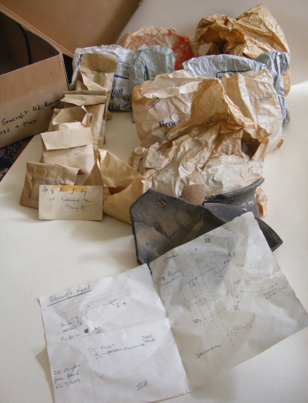
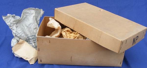
The image for today’s post on Day 294 of the VM_365 project shows the contents of some of the paper bags, stored in an archive box from an excavation carried out by Joe Coy with the Thanet Excavation Group at Dumpton, between Broadstairs and Ramsgate in 1964.

To understand how important the information contained in the archive is, we need to carefully examine how and why each item has been stored and labelled. In the image above the sherds are laid out on the paper shop bags they were stored in so that they can be assessed in more detail. Later they will need to be catalogued and put into plastic bags which will help to ensure their safe storage in the long term

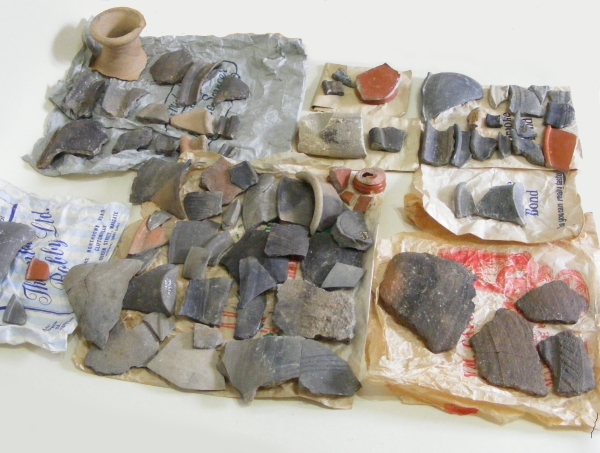
All but two of the bags in the 1964 excavation box contain pottery sherds. The sherds have generally been marked with a site code and feature number, which we now know corresponds with feature numbers on the sketch plan in the box.

There seems to be no corresponding finds list, description of the pottery or dating for the items in the archive box, so each pottery sherd  may have to be re-examined to understand the date range of the features fully.

However even a casual examination of the material reveals the span of the dates covered by the sherds, apparently a classic assemblage spanning the Late Iron Age and Early Roman period. Many of the pottery sherds are comparable with typical vessel types from other sites the local area, which have featured in earlier VM_365 posts.

The site excavated by Joe Coy and the Thanet Excavation Group in 1964 is very close to a large site excavated at Dumpton Gap by Howard Hurd, one of Thanet’s archaeological pioneers. Although Hurd emphasised the Iron Age aspects of his site, described by him as the remains of ‘a Late Celtic Village’, later excavations suggested that there was a more significant Roman element to the settlement than was previously thought. As we start to understand the 1964 archive, it looks likely that this will make a significant contribution to understanding that Roman settlement phase here.

The analysis will continue in subsequent posts.

VM_365 Day 293 What’s in the archive box?

VM 293

The Image for Day 293 of the VM_365 project is of the contents of the small cardboard archive box we started to look at in the post for Day 292. Although we have an idea from the label of the general area where the material may come from, a site at Dumpton Down between Broadstairs and Ramsgate, there is no record of what is actually in the box.

Our first task is to see what sort of material the archive contains, and what condition it is in. Then we need to know what sort of information it might be able to give us. In fact, even at first examination the box contains some very useful material. At least the box doesn’t contain bags of unwashed pottery or dried up leather.  The artefacts, which generally seem to be  pottery sherds of small to large size, seems to have been processed well.

Among the  containers stored in the box amount to eight paper bags from shops, which in themselves amount to something of a historic archive. There are also eight small brown paper envelopes, of a type people would have received cash wages in. Another similar wage packet envelope as a clear window in the front. There is one standard small brown envelope and a quantity of loose pottery sherds, some glued together to reconstruct part profiles. A small card in the box has the address of the excavator, Mr. Joe Coy,  from the  1960’s or 70’s written on it.

Best of all, there is a small paper sketch plan of an excavation, possibly where the artefacts came from. It’s not a perfect plan but it will help to evaluate what the finds in the bags can tell us. Each bag seems to have a feature code written on it, which may correspond with the plan and most of the sherds are marked with a site and feature code.

Although perhaps the containers leave something to be desired in archive stability, polythene mini-grip bags are probably preferable to a paper bag from a butcher’s shop in Margate, they have retained their contents reasonably well in the half century since the excavation was carried out.

In our next post for VM_365 Day 294 we will take a look at what is actually in some of the bags and what we might learn from the finds.

VM_365 Day 292 Unseen archives hold untold stories

VM 292

Today’s image for VM_365 Day 292 is of an unknown quantity, an archive of archaeological finds and records that has not been examined for decades. The long archive box above has a label that identifies it as being from an excavation carried out in 1964 by one of Thanet’s pioneering archaeologists Joe Coy, leader of the Thanet Excavation Group in the late 1960’s and 1970’s.

All over Britain there are similar collections of unexamined material that may hold all kinds of useful and informative material. What could we learn if each one of these collections could be opened and assessed? Digs that are decades old may have useful material to help with the interpretation of old sites and more recent excavations.

To begin with, the label on the box at least gives the artefacts in it a  location, a site near Dumpton Gap, on the east facing downland between Ramsgate and Broadstairs facing the sea to the east. Many excavations have been carried out in the area, over decades and by different groups and excavators.

The archaeological data we have for the area is widely distributed, and is in many respects rich and complex, but rather than a blanket of information we have something more like a moth eaten sheet, full of holes and missing pieces because of the tragic effects of time and entropy on the records and archives. After long years of travel and storage this small archive has finally ended up in the Trust’s collection. It has become our responsibility to  understand and preserve the material in the archive and pass it on as fully as we can.

This post for VM_365 will be the first of series that follows our exploration of what is almost an archaeological excavation in itself. We will begin to unpick the layers of material contained in the box and try to understand the value of each deposit and artefact that we discover.

VM_365 Day 290 Burial at centre of small round barrow at North Foreland

VM_290

The image for Day 290 is of a burial that was located at the centre of the  platform within the ring ditch of a Bronze Age round barrow which featured in the post for Day 289.

The main grave cut containing the burial was rectangular in plan, measuring approximately 1.75 metres long and 1.05 metres wide. The corners were rounded and the sides were vertical on the northern and southern edges. The eastern and western edges had steep slightly curved sides and the whole feature only measured 0.3 metres deep. The base of the cut was rough and uneven and the burial itself was contained in a slight rounded hollow, aligned approximately north east south west, which lay at the base of the rectangular cut. A chalk deposit with an inner edge that corresponded with the edges of the hollow in the base of the grave cut suggests that like other graves on this site it was retained by a coffin structure which did not survive.

The skeleton had eroded considerably, with only solid long bones left to indicate the original layout of the burial; their position within the grave suggests that the body had been placed in a crouched position with the head to the south, facing west.  Although the remains were poorly preserved and fragmentary, enough remained to be able to determine that they were the bones of an adult, aged approximately 25 -35 years old.

The deposit immediately above the skeleton, within or above the coffin, incorporated fragments of charred wood along with charred wheat and barley grains. Two small sherds of early Iron Age flint tempered pottery found in this deposit seem to be intrusions from the heavy truncation from the later Iron Age settlement on the site.

Despite the poor level of survival of this grave, much information remained to be discovered through the excavation and analysis of the grave and the burial.

VM_365 Day 289 A small Bronze Age barrow with big stories to tell

VM 289
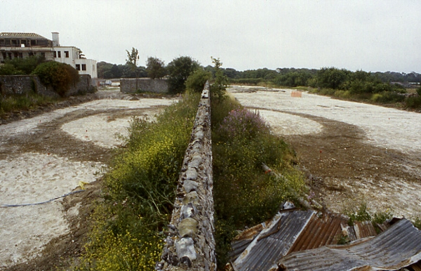
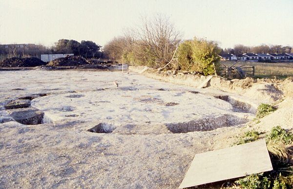
For the image on Day 289 we have a picture of the ring ditch of a small round barrow,  located at the western edge of the St. Stephens College excavation site at North Foreland, Broadstairs. The barrow stands on the crest of the chalk ridge with the land falling away to the north and north west.

The ditch was formed of two fairly regular arcs, joined by a short straight ditch at the southern end which created an almost complete circuit with a diameter of 9.6m. On the northern side of the ring ditch a 0.4m gap between two square ended terminals formed a narrow causeway from the outside to the inside of the circuit. The small dimensions and irregular shape have been compared with a barrow of similar dimensions that was found at South Dumpton Down, Broadstairs. The primary burial at Dumpton Down dated to the Beaker period, in the Early Bronze Age, suggesting the barrow at North Foreland dates to the same period.

The ring ditch at North Foreland was excavated by digging fourteen segments at regular interval through the dark loam deposits with irregularly distributed chalk and flint inclusions that filled the ditch. A flat based profile with very steeply sloping or near vertical sides was exposed along the whole length of the ditch, which only survived to a depth between 0.42 and 0.57m;  the width varied from 0.75 and 0.9m.

Like many of Bronze Age barrows featured in the VM_365 posts, on Day 271 and Day 286,  several of the upper fills of a ditch originally cut in the Early Bronze Age contained pottery dating to the Iron Age. Like the other barrows, this small example must have remained as an earthwork in the landscape, only to be completely filled in the later Iron Age period.

Two grave cuts were identified within the circuit of the barrow ditch; one positioned centrally and the other on the southern edge. Another more unusual grave cut was  found cut into the base of the north western arm of the ring ditch, these will be explored in more detail in later VM_365 posts.

VM_365 Day 288. Secondary Bronze Age burial within refurbished Barrow at North Foreland

VM 288

Today’s image for Day 288 of the VM_365 project shows a small oval grave that was located on the inner north west edge of a refurbished ring ditch, which was featured on Day 286 of the VM_365 project.

The skeletal remains were in a tightly crouched position, with the arms and legs flexed suggesting the body may have been tightly wrapped. The body, possibly a male aged between 14 -16 years old, had been placed on its left side, with its head  facing east at the north end of the grave cut.  The upper body was twisted so that the skeleton lay almost face down.

The grave cut was much smaller than the  burial that was placed at the centre of the original ring ditch, measuring just 1.04 metres long by 0.7 metres wide and with a depth of 0.5 metres. There was evidence that a coffin or containing structure, perhaps a woven basket, surrounded the immediate area of the burial.  A void around the skeleton had been filled by a deposit of silty clay derived from decay of organic matter and the percolation of silts from the surrounding deposits. The finer soil was retained within a chalky grave fill packed around the body, some of which is shown still in place in the picture above. The clean white chalk of the undisturbed chalk geology can be seen at the outer edge of the regular eliptical cut.

The upper fill of the oval grave pit incorporated the remains of a secondary burial, represented only by some unfused fragments of vertebrae and teeth, suggesting  a juvenile. No evidence of a secondary grave cut through the fill of the earlier burial  was identified during excavation. A small sherd of worn early Iron Age flint tempered pottery was found near the primary burial, but it is thought this may have intruded into the fill when the second burial was inserted in the early Iron Age.

The sequence of burial and the refurbishment of the ring ditch that defined the edge of the barrow show that once these structures were built, they  were sustained as places of significance over many centuries and cultural changes. Their meaning to each successive generation may also have changed but their physical presence was a fact in the landscape which only reduced in definition and scale over a long period of time, and could when necessary, be restored to gain new importance.


VM_365 Day 287 Central burial, Bronze Age Barrow, North Foreland

VM 287

The image for Day 287 of the VM_365 project shows the burial that was located at the  centre of the ring ditch of the Bronze Age barrow that featured on Day 286 of the VM_365 project. A second burial, probably inserted at a later date and associated with the refurbishment of the ditch circuit, was located on the northern edge of the Barrow platform

The large rectangular grave cut measured approximately 2.6 metres long by 1.6 metres wide and  was 0.76 metres deep, with a north east  to south west orientation. The skeletal remains of a mature adult male, aged approximately 30-40 years old were found at the base of the cut. The body been placed on its left side in a crouched position with arms and legs flexed, facing east. The head lay at the northern end.

In the image a chalky fill remains in the grave after a softer inner deposit had been removed to expose the skeleton. The soft deposits surrounding the body suggest that it may originally have been placed within a coffin, or similar structure such as a wicker basket which retained the chalky fill against a vertical edge. The inner area retained by the structure measured approximately  1.05 metres wide by 2.08 metres long. This was placed in the northern half of the grave cut and the space left at the foot of the grave may have contained food or other offerings which have not survived to be recovered in the excavation. The grave seems to have been backfilled around the inner chamber soon after the coffin was deposited in the grave.

In the upper fill of the grave there were 44 sherds of Early Iron Age flint tempered pottery and fragments of charred wood, which may be associated with disturbance from the Iron Age settlement that was established around the barrow.


VM_365 Day 286 Bronze Age Barrow, refurbished in the Late Bronze Age

VM 286
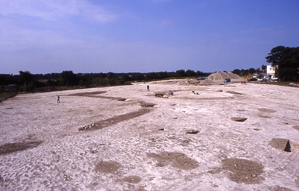
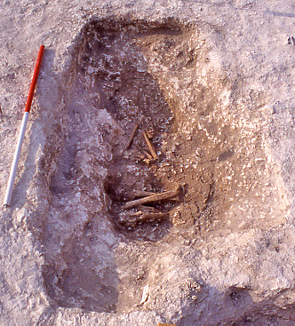
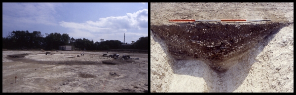
For Day 286 of the VM_365 project we have an image that shows another of the ring ditches of a Bronze Age barrow, excavated at St Stephen’s college, North Foreland in 1999.  The ring ditch was shown in an  overview of the site which was the image featured on Day 284 of the VM_365 project.

The picture on the left shows the barrow ditch under excavation, with a series of segments being excavated from the fill to show the layers of deposits in profile. The picture on the right shows the profile of one of the excavated segments  showing the sequence of multiple fills and interfaces in section, revealing that the circuit that was seen in the ground was in fact formed of two superimposed ditches cut at different times. The earlier ditch circuit had been at least partly filled in and had been refurbished by digging a new circuit around the same footprint.

The original ring ditch, measuring 18m in diameter, was probably cut in the late Neolithic/Early Bronze period, contemporary with a burial that was located at the centre.  The earlier ditch cut was slightly irregular, having been formed of a series of  straight segments in a similar manner to the ring ditch shown on Day 285. The profile measured approximately 1.5m wide and varied between 0.6 and 0.7m deep. The earlier ditch had been cut with a flat base, with steeply sloping sides angled at approximately 60°, part of this flat based profile can be seen in the right hand side of the picture of the section on the right.

The surviving fills of the primary cut which had not been removed by later activity  consisting of thin laminated bands of loam and chalk fragments, often with a fine graded appearance suggesting the erosion of the chalk barrow mound and edges of the ditch. It is likely that the earlier ditch had filled entirely before it was recut along the same circuit, probably in the late Bronze Age. This time the ditch cut had a steep V shaped profile, which cut away one side of the old circuit and penetrated the chalk below the flat floor as well.

The intersection of the two different cuttings can be seen most easily in the right hand image, by following the chalk in the cut from left to right. The steep side of the original ditch breaks to the platform of the original base, which then breaks sharply at a steep angle to the V shaped notch cut by the new circuit. The right hand side of the notch rises at the same angle along the inner edge of the new ditch cutting.

The later refurbishment of the barrow by cutting a broader ring ditch with a V shaped profile through the filled earlier ditch suggests the original barrow may only have existed as a raised earthwork rather than a ditch, although it may have been an impressive feature even after years of weathering.

Why was the ditch circuit recut on the same plan?

Two grave cuts were identified within the Barrow platform. Because of its regular placement in relation to the circumference of the ditch,  the central burial is likely to be associated with the original construction of the Barrow. It is possible that the other burial, which lay in a smaller oval cut,  may be associated with the refurbishment.

The newly cut ditch probably also remained a prominent landscape feature for centuries, its ditches still visible as deep hollows around the circuit. The  post for VM_365 Day 271 featured a bronze age barrow ditch that must have still been a substantial earthwork in the Roman period when large amounts of pottery were tipped in to its upper fills.

In the upper fills of the recut ring ditch at North Foreland pottery in transitional Late Bronze Age/Early Iron Age fabrics was found in relatively large quantities, along with small amounts of 6th century BC pottery contemporary with the earliest occupation features of the  Iron Age, suggesting that the final filling of the re cut barrow occurred early in the Iron Age when the hill top was being turned into a nucleated settlement, with enclosures and clusters of post built structures, served by a major trackway leading from the sea.


VM_365 Day 285 Bronze Age Roundbarrow?

VM 285

The image for Day 285 of the VM_365 project shows one of the three ring ditches that were excavated in 1999 at the St Stephens College site, at North Foreland, Broadstairs. The cropmarks extending along the valley side (to the right of this image) were shown on Day 283 and an overview of another of the barrows, an Iron Age enclosure and storage pits (located in the area at the top of this picture) were shown on Day 284 of the VM_365 project.

Two sections of this ring ditch, which are assumed to be a continuous circuit, were exposed on either side of a standing flint wall, which is part of an early 19th century Grade II listed structure and was left in place. No internal graves were found which could confirm that the ring ditch was a round barrow, but as the central part of the feature was obscured by the wall and an unexcavated area either side of it, a central grave could perhaps exist there.

The ring ditch measured 21m in diameter was formed of a series of  fairly straight cuts, each roughly 2.5m in length, which intersected at acute angles to form a ring. The profile of the ditch was fairly consistent measuring 0.74 metres deep with steep, approximately 60° edges and a flat base. The fills of the ditch did not indicate any bias in the direction of filling  to suggest the presence or composition of a central mound enclosed by the ditch.

Pottery of Early Iron Age date was found in the uppermost fills of the ditch, which were presumably incorporated when the ring ditch was almost entirely filled and the major Iron Age settlement was established to the south in the early 6th century BC, replacing the Bronze Age pattern of landscape use for funerary monuments with a  hill top village.


VM_365 Day 284 Excavation of a Prehistoric site at North Foreland, Broadstairs

VM 284

The image for Day 284 of the VM_365 project shows archaeological excavations in progress in 1999, at the site of St Stephen’s College, at North Foreland, Broadstairs. The view in this picture faces north west toward the mouth of the Thames Estuary, although the sea is hidden behind the range of trees at the top of the picture.

The  St Stephen’s College dig site is located just to the east of the cropmark group at North Foreland that was shown in yesterday’s image for VM_365 Day 283. One of the ditches that shows in the cropmark extended into the site.

The wide range of features found on the site are all represented in the picture. On the top, right hand side is the ring ditch of one of three Bronze Age round barrows excavated on the site. This barrow contained three burials, a large rectangular central grave cut and a second, smaller, oval grave cut on the northern side of the Barrow. A second burial had been inserted in the upper fill of that grave. The circuit of the barrow ditch had been recut in the Iron Age, possibly to form a hut platform.

On the left side of the picture you can see the ditches of an enclosure, dating to the Middle Iron Age. An  entrance causeway formed by a break in the ditch circuit can be seen at the front. Some of the ditches that branch to the top of the hill from the trackway that can be seen in the cropmarks on the hillside lead directly to the rectangular encloure.  At least six structures built with four timber posts were enclosed within the rounded rectangular ditch, although these could be from a different phase of the settlement when the ditch was no longer visible.

The group of storage pits visible in the foreground, close to the entrance of the enclosure, were dug over a period of time spanning the Middle to Late Iron Age.  One of the storage pits located in another part of the site, not shown in the image,  was reused for a burial which featured in a sequence of VM_365 posts on Day 123, Day 43 and Day 113. Iron Age objects found in some of the pits excavated on the St. Stephen’s site including Bridle bits, a bone handle, loom weights and evidence for chalk plastered structures have also been posted as part of the VM_365 project.

The tiny figure present in the middle of the enclosure is the Trust’s first Director Dr Dave Perkins who led the excavations in 1999.