Category Archives: VM_365 Project

VM_365 Day 90. Roman Equal-ended Brooch

VM_90

Today’s image for VM_365 Day 90 shows another brooch from Abbey Farm Villa, Minster. This equal ended brooch was found in the subsoil above buildings found on the southern side of the villa complex along with a small quantity of 2nd century pottery.
Over time this copper alloy brooch has become corroded but we can still see that it  has a rectangular plate with lugs. The centre has three equal sized rectangular cells filled with enamel; the bottom cell is coloured red, the middle cell is now empty and the top cell appears to have been green or yellow enamel. Either side of the enamelled cells is a side panel with a beaded rim and rectangular lugs at the corners. This type of brooch was widespread in the 2nd and early 3rd century.

VM_365 Day 89. 2nd Century Brooch from Minster, Thanet

VM_89

Today’s image is of a 2nd/early 3rd century brooch from Abbey Farm Roman Villa, Minster-in-Thanet. It was found in the upper fill of a well shaft which had been deliberately backfilled with large amounts of pottery and domestic rubbish. The pottery from the well shaft dates to the 2nd century with a few sherds as late as the early 3rd century.

The brooch is equal ended with a rectangular plate and two circular lugs. The projections are moulded and decorated with two sets of concentric circles and are broken at either end. In the centre of the brooch is a rectangular cell which was filled with enamel, now coloured yellow. The lugs are also decorated with two circular yellow enamelled cells.

References
Parfitt, K. 2007. The Roman Villa at Minster-in-Thanet. Part 4: The South-West Buildings, 6A and 6B. Archaeologia Cantiana CXXVII, 261-296.

VM_365 Day 88. Rosette brooch 1st Century AD

Thistle or rosette brooch of 1st century date from Minster in Thanet

Today’s image for VM_365 Day 88  is of a brooch from the 1st century AD, which was found in the excavations at the Abbey Farm Villa at Minster in Thanet. This type of brooch has a cast thistle or rosette form with elaborate relief decoration. A cylindrical roll of metal covers the spring for the fastening pin at the back of the brooch.

This type of brooch was first made in the first half of the 1st century AD, before the Roman conquest of Britain. The rosette or thistle brooch was commonly used on the continent, particularly in Gaul and on the German frontier, as well as in southern Britain before the Roman invasion. This type of brooch is occasionally found on sites that date from shortly after the Roman Conquest and often accompanying burials of the early conquest period.

They may have lasted into the Roman period as family heirlooms, because of their particularly fine style and quality.

Reference

Bailey, J. and Butcher, S. 2004. Roman Brooches in Britain. Reports of the Research Committee of the Society of Antiquaries of London No. 68. London.

VM_365 Day 87. Local materials for local bakers.

Large flint nodule worked into a grinding surface

Today’s VM_365 image shows two artefacts from Iron Age sites in Thanet. One is a large stone with a flat grinding surface, found at a large Iron Age settlement site at South Dumpton Down near Broadstairs. The second object is a spherical rubbing or grinding stone, which fits comfortably into the hand, which comes from a contemporary site at North Foreland, Broadstairs.

The two objects demonstrate how local materials, in this case flints from seams within the chalk that underlies both sites, were adapted for tools associated with daily activities. Both objects were transformed by regular working into something quite different to their irregular natural state.

The surface of the larger flint was pecked and ground to a horizontal surface by the rubbing and grinding action that may have taken place every day. The smaller flint was chipped and ground into a sphere through a similar regular striking action, possibly while it was used as a rubbing stone used on a similar flattened surface. Rotating the object in the hand for comfort  probably created the spherical shape over time.

The combination of the two objects, under the power of a human hand, created an abrasive process, which was possibly used to rub grains between the stone to make flour, or to grind other foodstuff into powders or pastes.

VM_365 Day 86. Wooden box stores Roman samian collection

Box stores Roman samian vessels from Drapers Mills, Margate

Today’s VM_365 image is of a collection of  whole vessels and large sherds made from a disticnctive type of Roman pottery called samian ware.

This selection comes from the archive of the excavation carried out at Drapers Mills near Margate between 1959 and 1961 by Mr Joe Coy. The site is known to have been the location of a major Roman building, probably a Villa, which has produced many interesting finds such as the boxer’s head shown in an earlier post.

Over the years the Trust for Thanet Archaeology has acquired the archives of several early excavations carried out by some of the pioneering archaeologists in Thanet. Although we have been supported with donations from our wish list and with funding for storage material, we have limited resources to do everything we might to understand and examine in detail all the material we have in storage.

When we are able to open up and examine the contents of a box, it can reveal hidden treasures like this group of samian vessels and sherds.  Samian was a high status product, manufactured in very large quantities from the early 1st century to the mid 3rd century AD. Samian producing kilns were located in southern and northern France and later in southern and eastern Germany, which were part of the province of Gaul.

Now this important group of material has been rediscovered, it can be examined and dated using up to date knowledge of the production centres and manufacturers. As more is learned from the material archives, the real significance of the Roman sites we have identified in the map of Roman Thanet becomes clearer.

The pottery in this image was discussed in greater detail by Dr. Steve Willis, a specialist in samian ware, on Day 345 of the VM_365 project. An interesting observation on the parallels between the origins of some of the pottery and the box the material was stored was discussed on on Day_346.


VM_365 Day 85. Bronze Age Incense Cup

84

This unusual little vessel is a perforated Incense or Accessory cup of Early Bronze Age date. The vessel was found in the late 1970’s in a pit at the centre of a ring ditch which had been partially destroyed by the construction of the Haine Road at Lord of the Manor, Ramsgate.  The ring ditch is one of a group of at least seven Neolithic and Bronze Age Monuments located on a chalk hilltop overlooking Pegwell Bay; one of the major ceremonial sites of prehistoric Thanet.


VM_365 Day 84 Medieval pottery from a refuse pit in Margate

VM 84

Today’s VM_365 image is of a large pottery cauldron or ‘stewing pot’, possibly dating from the 11th to the 13th century (c.1075-1100/1225 AD). The vessel was excavated from a contemporary medieval refuse pit at East Northdown Farm, Margate in 2003. The pit contained  sherds from six or seven pottery vessels, all made of Canterbury Sandy ware fabric, including the one pictured.

The pit also contained a large quantity of animal bones and large lumps of bonded clay and chalk which could have derived from the demolition debris from a nearby structure. Soil samples taken from the pit included fragments of barley, oats and elder, the cereal crops suggesting the agricultural products that were used for human consumption or animal fodder when the broken pot was thrown away.

VM_365 Day 83 Early Saxon Settlement at Margate?

VM 83

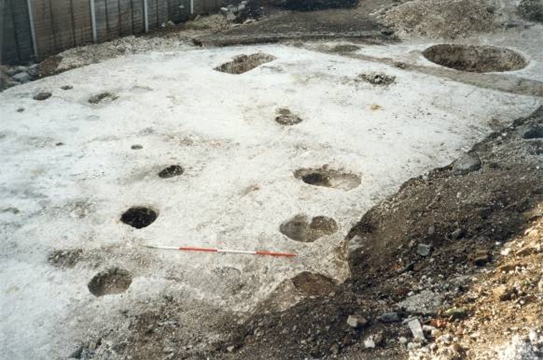
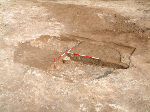
The image for VM_365 today shows the heavily eroded remains of an Anglo-Saxon structure, under excavation in 2005 at a site near the QEQM hospital, Margate .

Evidence for large early Anglo-Saxon cemeteries is abundant on Thanet, with remains having been excavated at Ozengell, Sarre, Valletta House, Half Mile Ride, Monkton, St Peters, Thorne Farm and Cliffsend. Aerial photographs have provided further evidence of  cemetery sites at Brooksend and Crispe Road, Birchington. However, contemporary settlement, indicating where the people buried in the cemeteries might have lived, is much less frequently encountered in Thanet.

Few, if any,  early Anglo-Saxon timber framed hall style buildings have been recognised in the area and the only early structures of this date recognised so far  on Thanet have been a type known to archaeologists as ‘Sunken Featured Building’or SFB’s for short. Where these structures have been identified elsewhere in the country, they have been dated to the post Roman ‘migration’ period of the 5th century, when the Anglo-Saxon people first arrived in Britain, with the form living on into later centuries.

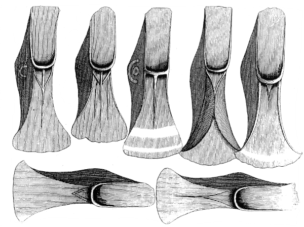
The SFB is usually formed of a rectangular pit, with an arrangement of postholes around its edge in which upright posts had been placed. Reconstructions from sites such as West Stow in Suffolk suggest the rectangular pit formed a void or cellar over which a planked floor was laid and timber posts in various arrangements around the edge formed the supports for a superstructure above. Examples of SFB’s excavated at Dover suggest the sides of the void could also have been lined with timber planking. Reconstruction look something like a large garden shed with a timber lined pit under its floor.  The elements of the pit that remain to be discovered by archaeologists because they were cut deep into the ground and have survived the later erosion of the ground surfaces through ploughing, which destroyed much of the evidence for the surrounding structure.

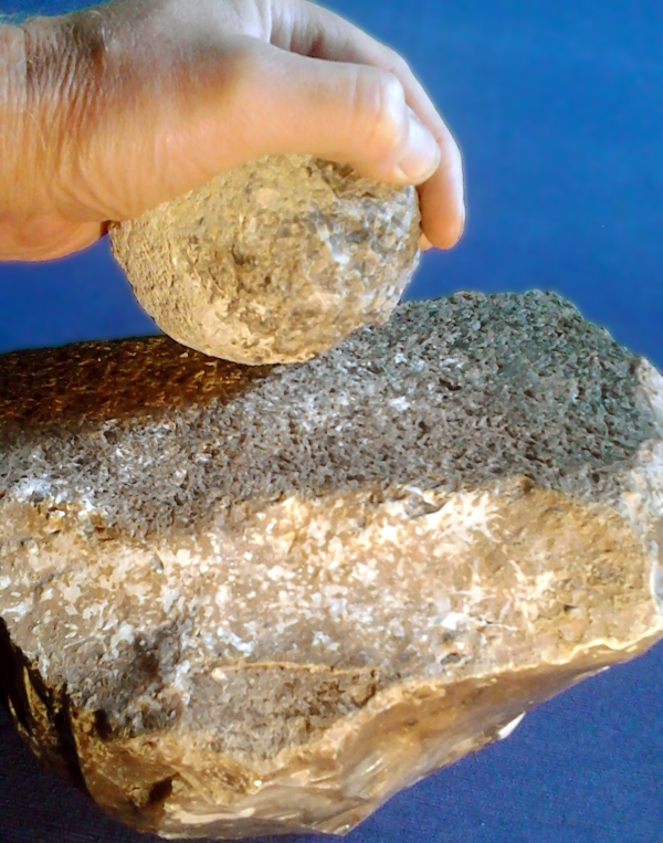
The  remains of the SFB at Margate, shown in the picture, comprises a shallow rectangular cut measuring 3m by 2.5m, with two deep postholes in the centre of each of the short sides. A large fragment of  stone, part of a quern, that was found in the centre of the rectangular cut may have been a pad supporting an additional upright timber. The SFB was dated to the mid-6th to 7th century by fresh sherds of chaff tempered pottery from two or three vessels that were found in the backfill of the cut.

What were these buildings for?

Sunken Featured Buildings are most likely to have served several purposes, but they were probably not  domestic dwellings as was once suggested. The planked floor over a void has been interpreted as evidence that the SFB’s were used to house large weaving looms, the floor void allowing the loom weights to be suspended below a working platform and giving a better working area. The two upright postholes may have supported the frame of the loom. Shale loom weights and a bone pin beater have been excavated from an SFB at Ramsgate and an SFB found in Dover contained clay loom weights, preserved in their rows following a fire that destroyed the loom. Other examples have been found with hearths on the floors and it is possible that one of the many uses an SFB could be adapted to was a smoke houses for drying or preserving produce.


VM_365 Day 82 Iron Age structure at Fort Hill, Margate

Fort HIll, Margtae
Fort Hill, Margate

Today’s VM_365 image shows a group of six postholes that formed the foundations of a structure, which were recorded in part of an Early Iron Age settlement that was excavated at Fort Hill, Margate in 1998. The postholes, which are shown in the foreground of the picture, were dated to  by 17 sherds of flint tempered pottery found in the fills of two of the postholes to the Early Iron Age.  Other finds from the fills included flintwork and burnt flint.

It is difficult to say what form the  structure would have taken above ground.  The dimensions of the  timbers contained within the six supporting posts  indicated by the postholes, suggest they would have been fairly substantial and could have formed the internal supporting structure of a roundhouse with a front porch. Four of the posts with a horizontal beam tied to their tops supporting a series of timber rafters and the other two supporting a door opening joined to the main body of the building.

An alternative suggestion is that they represent free standing platforms, supporting drying racks for grain or perhaps hides during the process of tanning. Although the postholes provide valuable evidence of a durable structure, it is very difficult to interpret the true form of the features beyond our efforts to make comparisons with existing examples in living cultures, or conjecture the form of the buildings or platforms based on layout of the posts that we assume occupied the holes.

VM_365 Day 81 The first recorded discovery of a Bronze Age hoard in Thanet


Mutrix Hoard
Mutrix Hoard

Today’s image shows an illustration of some of the objects in the first Bronze Age Hoard whose discovery was recorded on Thanet. The hoard, consisting of twenty seven palstave axes dating from the Middle Bronze Age,  was found in 1724 at Mutrix Farm ( a place name also recorded as Mutterer or Motherwicks) on the cliff top near St Mildred’s Bay, Birchington. A record of this discovery, with the illustration shown above, was published in 1736 by the Reverend John Lewis in his book on the History and Antiquities of the Isle of Thanet:

‘Betwixt this place and the Sea were found AD 1724 by William Castle, who occupied a small Farm here, as he wwas digging a Sea-gate, or a Way thro’ the Cliff into the Sea, to fetch up Oore or Waure for his Land, XXVII such instruments as I have described in the adjoining Plate lying all together about two Feet underground, so that it is a little strange, that they were not before this discovered by the plough. They were of mixt Brass, or what they call bell or Pot-metal, of several Sizes, and somewhat different shapes, but on both Sides alike, as they are here represented. The largest of them were 7 Inches one quarter long, and 2 Inches three quarters broad at the bottom the lesser ones were 5 Inches in Length and 2 Inches and one half in Breadth at the Bottom. Two of them had Ringles on one Side about the middle, which was the thickest or deepest part.’

It has been suggested that the illustration reproduced by Lewis was copied from an original drawing made by the famous Antiquarian William Stukeley while he was travelling through Kent (Ashbee 2001).

References

Ashbee, P. 2001. William Stukeley’s Kentish Studies of Roman and other Remains. Archaeologia Cantiana 121, 61-102.

Lewis, J. 1736. The History and Antiquities of the Isle of Tenet. London. 2nd Edition

Perkins, D. R. J. 2000. A Gateway Island. Thesis submitted for the Degree of Ph.D to the Institute of Archaeology, University College London.