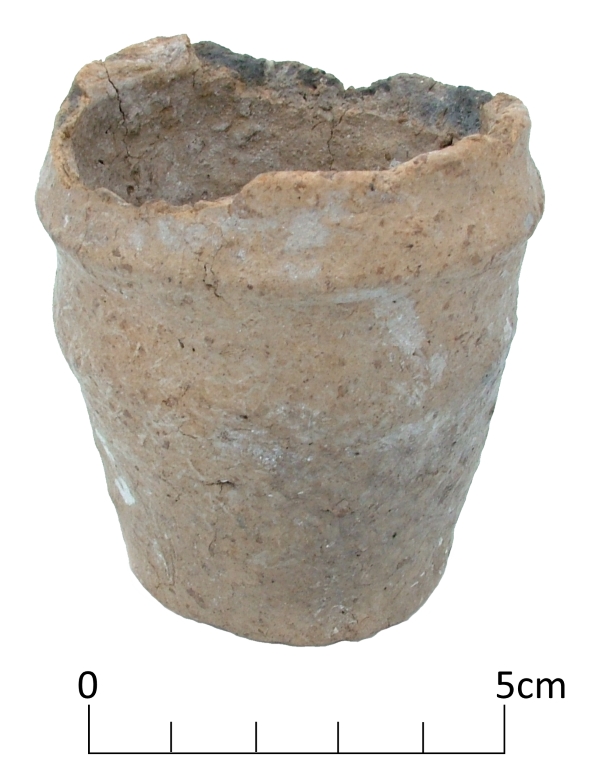
An unusual Early Bronze Age miniature collared urn discovered in the North Foreland area of Broadstairs is shown in our image for VM_365 today.
While building a house on a plot in North Foreland Avenue in 1979, workmen rescued the tiny vessel from a pit after they had uncovered the ring ditch of a round barrow. Rescue excavations on the site traced part of the ring ditch as well as human remains from a later period within the same site, representing at least five Iron Age burials.
The Collared Urn, which has an estimated date range of 2000 – 1500 BC, is one of a few examples of tiny versions of these vessels that have been found in Britain. The urn may have been placed in the central burial of the barrow, which had already been built over when archaeologists investigated the site.
Miniature vessels like this may be token representations of their full size counterparts, used as a substitute in certain cultural conditions, or they may represent the smaller end of a range of functional vessels, collared cups rather than urns.
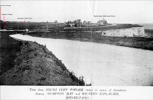
Yesterday we introduced you to Howard Hurd, Thanet’s first scientific archaeologist. Today we show you some of the archaeological work carried out by Hurd at Dumpton Gap and South Cliff Parade, Broadstairs.
The image above, taken c. 1907 for a land auction catalogue, shows what Dumpton Gap looked like as the new estate was being laid out along the cliff top between Dumpton Gap and Broadstairs. The view is taken from South Cliff Parade, near where the entrance to Seacroft Road is now.
In the background the buildings that were already constructed are marked; Buckmaster Memorial Home, along the Western Esplanade and Yarrow House (now East Kent College) on the edge of the picture. The beginning of Waldron Road and Dumpton Park Drive are visible in the background. At the top of the cutting leading down to Dumpton Bay you can see the buildings associated with the entrance to a submarine telegraph.
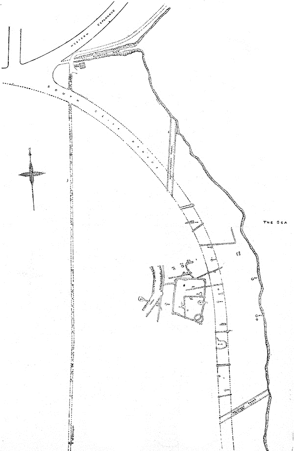
In his capacity as Town Surveyor and Engineer, Hurd recorded the archaeological features that were exposed during the work and published reports on them. You can see from the meticulous plans that he published in 1913, that many archaeological features were revealed when the roadway was stripped. The features include a small prehistoric round barrow, pits, ditches and the settlement enclosures which he referred to as a Late Celtic Village.
Excavations carried out at Seacroft Road by the Trust for Thanet Archaeology in 2006 allowed us to revisit a small part of the area that Hurd recorded. Our plans of the site overlaid almost perfectly with his and our excavations were able to establish that occupation on the Late Iron Age site, which Hurd referred to as ‘Late Celtic’, continued into the Roman period. Roof tiles, stone and pottery of Roman date suggest that a building was located in the area, perhaps the one described by the Reverend John Lewis in his History of the Isle of Thanet, written in 1736, as being present in this area.
Further reading:
Hurd, H. 1909. On a Late-Celtic Village near Dumpton Gap, Broadstairs. Archaeologia (Second Series) Volume 61 Issue 02, pp 427-438
Moody, G. A. 2008. The Isle of Thanet from Prehistory to the Norman Conquest. The History Press: Gloucester.
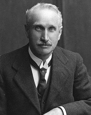
Howard Hurd was Thanet’s first scientific archaeologist. In 1897, at the age of 32, he was appointed Surveyor and Water Engineer to the Urban District Council of Broadstairs and St Peters in charge of the water supply and other services. His work on the new estates being constructed as the town expanded brought him into contact with many archaeological discoveries. The local construction workers were aware of his interest and brought things they had found to his attention.
Hurd produced comprehensive reports of his discoveries with accurate plans, illustrations and photographs. He recorded archaeological discoveries of Bronze Age Barrows at King Edward Avenue, Valletta House and Dumpton Gap; Roman cremation urns at Rumfields Road and the Anglo Saxon cemetery at Valletta House, now Bradstow School. In 1911 he was one of the founder members of the Broadstairs and St Peter’s Archaeological Society along with Miss Bartrum, the owner of Valletta House.
His work was the first accurate, scientific archaeological recording carried out on Thanet that still stands the test of time today.
Find out more by reading:
Moody, G. 2008. The Isle of Thanet from Prehistory to the Norman Conquest. The History Press: Gloucester. 19-20.
Hurd, H. 1913. Some notes on recent Archaeological Discoveries at Broadstairs. Broadstairs and St Peter’s Archaeological Society
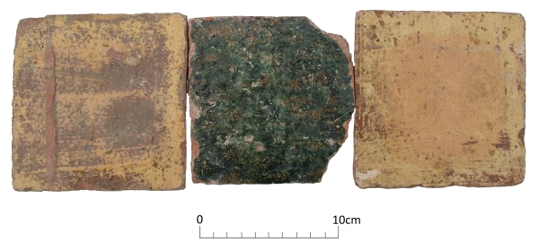
Today’s image shows three nearly complete floor tiles from the site of one of the lost medieval parish churches of Thanet; All Saints, Shuart. The site was excavated by the Isle of Thanet Archaeological Unit in 1978 under the direction of Frank Jenkins, assisted by Dave Perkins and site assistants from the Manpower Services Commission.
These plain glazed floor tiles were found in the demolition rubble of the latest phase of the church and are of Flemish manufacture dating to the late 14th to 15th centuries.
The Church was originally established in the 10th century, along with St Nicholas at Wade, as dependent chapels of the Church at Reculver. All Saints was altered and expanded in the 10th-11th centuries, 12th century and again in the 13th century. By the mid 15th century the church was in ruins and it was eventually demolished by about 1630.
The reason for its decline may be that the parishes of St Nicholas at Wade and All Saints were combined in the early 14th century and it later became too much of a financial burden for the parish to support two churches; All Saints was neglected in favour of St Nicholas at Wade.
Further reading:
Jenkins, F. 1981. The Church of All Saints, Shuart. In Detsicas, A. 1981. Collectanea Historica: Essays in Memory of Stuart Rigold. Kent Archaeological Society; Maidstone. 147-154.
Can we find out who this person buried in the ditch of a round barrow was?
What drives our interest in following the trail of evidence from aerial photographs to the archaeology in ground that has been shown in the VM 365 images over the last few days?
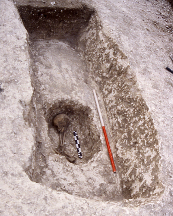
The image for Day 30 of the VM 365 project shows a human skeleton, a young adult that was buried in a small grave that was excavated into the terminal of the round barrow that was shown in yesterday’s image. The grave fill overlying the skeleton was covered with a large fragment of whale rib.
Rather than focus on the excitement of the excavation process that revealed this burial, we should pay attention to the motivation for carrying out the investigation which is often overwhelmed by the excitement about the external character of the results.
The fundamental reason for developing the methods of archaeological investigation was, and remains, curiosity about the places we live in and about the people who have occupied the same places in the past. There are no written records describing the circumstances and experiences of life in periods such as the Bronze Age which are represented in such abundance in the Isle of Thanet. There is no evidence that emanates from their direct experience, which could be used to reconstruct their lives. The people under investigation in these circumstances are truly pre-historic, we lack any tools but archaeological methods to generate knowledge about them and to create narratives of the events that affected them.
Our interest in the universal set of questions, who, where, what, why, and when will not rest for lack of easy evidence and careful exploration and analysis can be used to describe the circumstances of discovery in ever greater detail. Once we understand as much as we can about the circumstances of discovery, and describe them with as much precision as possible, we can begin to interpret the meaning of the things we have discovered. Archaeological investigation must also be used to established the limits of our knowledge. If we take careful note of the present conditions of our discoveries we can begin to understand that many things that are lost from the image of the past we can generate.
Archaeology is about exploring the deliberate construction of messages by people in the past, the signal, as well as the inadvertent or deliberate destructive processes that can distort part of the message, the noise. To produce good and thoughtful interpretation; assumptions should be questioned; different perspectives adopted on the data and our ideas subjected to critical review.
There is always something new to said and new information that can be gathered from the evidence collected by archaeologists. In the case of this burial, its inclusion in a research programme investigating Isotopic data that can be extracted from the teeth will in due course add more to the constellation of knowledge that gathers around the physical remains we recover from excavations.
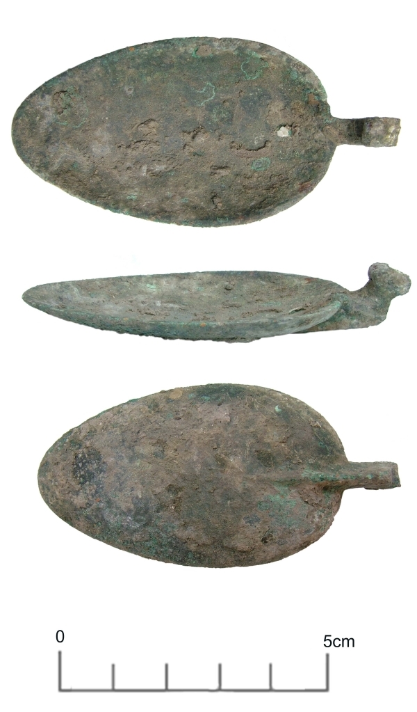
Just how old are spoons? A spoon (apart from a knife) is probably the oldest utensil known to man, being used to scoop up food to eat and for mixing and measuring. The oldest spoons were probably just scoops made from shells, later developing into purpose made scoops with handles and made from wood and bone. Some of the earliest known spoons with handles dating from around 1300 BC have been found in ancient Egyptian tombs and are carved from ebony and ivory.
Our copper alloy spoon bowl, found in a Roman building at Broadstairs in 2004, is much younger, dating to the late second century AD and is without its handle. It was found associated with an oven on the floor of the cellar in a thick sooty deposit that also contained pottery, iron nails, rings and fittings as well as a Roman military belt buckle suggesting that old timber and even clothing was being used to fuel the fire.
You can read more about the site in Moody, G. 2007. Iron Age and Roman British Settlement at Bishop’s Avenue, North Foreland, Broadstairs. Archaeologia Cantiana CXXVII
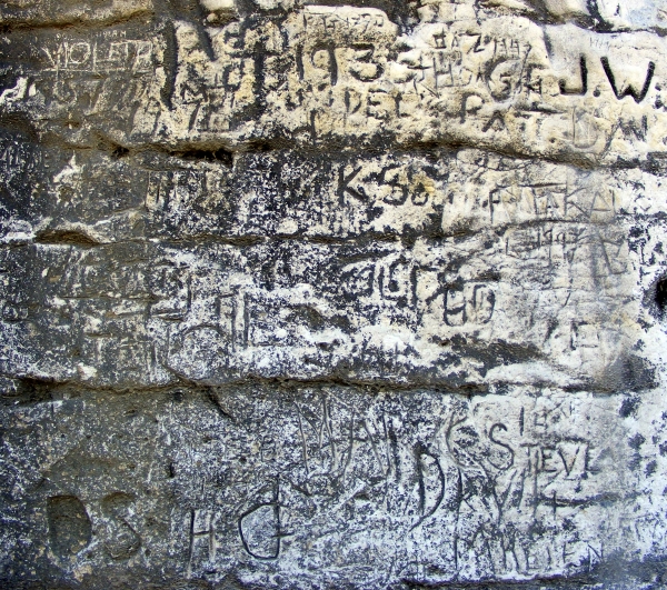
A palimpsest of texts inscribed on the cliff face west of Margate. Who is Violeta, what was special about 1935, is I Steve a vision of the future?
This is just a few metres of an immense running inscription, unfolding a theatre of memory and an archaeology of seaside experience. Will this record be pored over for its meaning in the future or are these human experiences as enduring as the chalk they are written on?
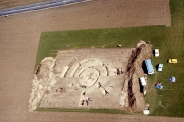
Excavations at Lord-of-The-Manor Ramsgate in 1976, revealing the ancient landscape hidden by the plough
The Trust for Thanet Archaeology is an educational charity and one of its aims is to teach people about Thanet’s very important past history, which has been revealed through archaeological investigation.
One of the problems faced by the Trust is that much of our archaeology remains hidden from view under the wide expanses of agricultural fields that cover the Island. Take a close look at the area surrounding the excavation in the image, which is as flat and featureless as any field could be. Yet below the thin covering of top soil are the remains of a prehistoric site, formed of several succeeding ring ditches that were used and adapted for many different ceremonies and burials from the Beaker period to the Bronze Age.
The importance of Thanet’s landscape in the past partly derived from the fertile soils and relatively warm weather, where the climatic conditions on this south east coast were not dissimilar to those of the near continent. For prehistoric peoples, the interaction with the coastal areas of Britain were not such a great leap as they would have been if the conditions were closer to those in the north of the the British Isles. The combination of close European connections, openness to innovation in culture and the fertile landscape, led to the formation of a dense record of past settlement that has been discovered in the Isle of Thanet.
Sites like the Lord-of-the Manor ring ditches shown in the image tell the earliest part of Thanet’s story , but their significance can really only be comprehended by looking at the records, reports and images that remain from the archaeological efforts to discover and investigate them. The intensification of agriculture from the medieval period onwards levelled the remains of the settlements of preceding generations, until only the truncated remnants lay buried under a swathe of plough soil, covering miles of flat ploughed fields.
Over time, each generation has done its best to prosper in the soil. For many centuries much of the landscape was in use as grazing land and we have archaeological evidence that ancient barrow mounds and ditches remained standing in the landscape in the Roman period. As late as the 19th century earthworks and mounds remained in the Lord-of-the Manor area of Ramsgate, where today’s image was taken during excavations in 1976.
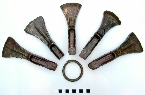
Today’s image is of a Middle Bronze Age hoard excavated at Dumpton Gap, Broadstairs in 1992. Five unused palstave axes and a bronze ring were found in a pit that cut through an enclosure ditch.
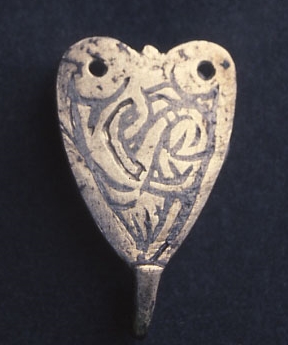
Today’s image from the archive is of a ninth century Saxon silver hooked tag excavated in 1991 from a ditch at Sarre. The hooked tag measures 2.5cm high and 1.5cm wide and is a crude design of a Trewhiddle style bird in niello inlay.
Decorated hooked tags are known from the seventh century and continue until the late Medieval period probably because they could be used multiple ways. The holes at the top of the plate were for fixing to cloth or leather and would have been used in a similar way to hook and eye fastenings. Similar tags have been found in association with coin hoards and may be purse fasteners, others have been found in graves where they may have been attached to garters.
 Just how old are spoons? A spoon (apart from a knife) is probably the oldest utensil known to man, being used to scoop up food to eat and for mixing and measuring. The oldest spoons were probably just scoops made from shells, later developing into purpose made scoops with handles and made from wood and bone. Some of the earliest known spoons with handles dating from around 1300 BC have been found in ancient Egyptian tombs and are carved from ebony and ivory.