VM_365 Day 27: Down to Margate Pier

VM 27Our image today shows that Archaeology doesn’t have to  be buried in the ground, or to be  ancient, to reveal an important story of the past.

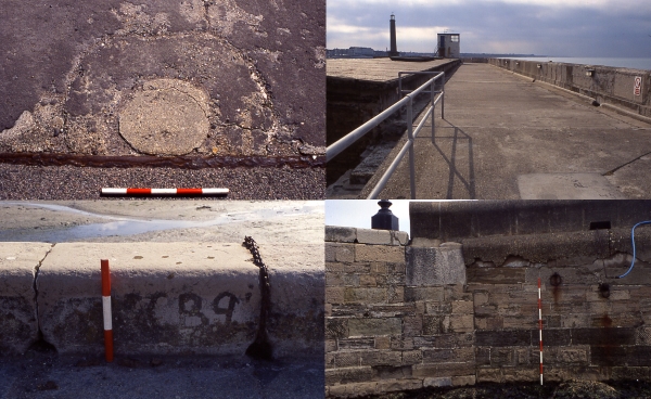
In celebration of the recent long spell of warm summer weather, we want to show that one of Thanet’s important seaside landmarks Margate Pier preserves much archaeological evidence of its us for industry and pleasure over the last 200 years.

Just look carefully for the fixtures and fittings that demonstrate that there were once many different uses for the pier, all related to Margate’s rich and diverse history. Even the stones of the pier tell a story, they were quarried at Aislaby in North Yorkshire.

If you can get down to Margate Pier this weekend, see if you can identify any of these or any other clues to the pier’s past history:

The picture shows clockwise from top left:

1. Metal crane track, used from the late 19th and early 20th for coal deliveries to the Margate Gas works

2. Scars of the tracks off the miniature railway that ran along the promenade in the 1950’s and 60’s

3. The original quoin stone and pier surface dating from the c. 1840’s at the landward side of the pier near the Turner Contemporary. This has been covered by later structures.

4.  Mooring positions inscribed into the edging stones along the inner harbour c. mid 20th century. NCB  probably stands for the National Coal Board.

There’s more information about Margate Pier in the Virtual Museum pages about our survey of the structure that was carried out in 2005, for the earlier design of the Turner contemporary – if anyone remembers that!

Let us know what you find if you visit the pier this weekend.


VM_365 Day 26 – Middle Bronze Age Cremation Urn from Ramsgate

VM 26
Middle Bronze Age cremation vessel, its location in a shallow pit with two other vessels is shown on the right

A small ring ditch cut into geological deposits was exposed in an excavation on the Westcliff at Ramsgate, carried out in 2002 on the site of a new housing development.  Irregular flint nodules spread over the area of the  ditch and retained in the soil that filled it suggested it may have been covered by a cairn.

Pieces of a coarse flint tempered vessel found at the base of the ditch,  linked the date of the ring ditch with that of a group of five truncated pits that were nearby. Each pit contained between one and three coarse flint tempered ‘Deverel-Rimbury’ style pottery vessels, all but one inverted so that they stood with their rims on the base of the pit. The bases of the vessels, which had been uppermost in the pits, had  been disturbed and destroyed at some later time.

Fragments of burnt human bone were distributed irregularly within the soil that filled each vessel. The burnt bone seems to represent material that had been collected from cremation pyres and placed in the vessels, rather than all that remained of the cremation of a single individual.

Today’s picture shows one of the pits (Pit A) being excavated, alongside a photograph of the best preserved Vessel 4, a straight sided, narrow mouthed bucket urn in a coarse flint tempered fabric, decorated down each side with two rows of finger tip impressions. The urn is inverted and stands on its rim as it did in the cremation pit.

All three vessels from Pit A contained cremated bone fragments, two with identifiable bone elements representing two individuals, a child around 10 years of age and an adult. Radiocarbon dating of a fragment of bone from one of the individuals gave a  date  between 1520-1310 BC, within the Middle Bronze Age.

There’s  more about the Middle Bronze Age in Thanet in the Virtual Museum’s Bronze Age gallery.

You can find out more about this site in the published report:
Moody, G., Macpherson-Grant, N. and Anderson, T. 2010. Later Bronze Age Cremation at West Cliff, Ramsgate.  Archaeologia Cantiana CXXX 147-172.

VM_365 Day 25 – The Invisible Element

Complex joinery in the upper structure of a large timber framed barn

Today’s image is inspired by a visit today to the excavations at Randall Manor in Shorne Wood Country Park, where a complex and prestigious medieval building is now only represented by the footprint of its foundations and low walls.

Although parts of the building may have been constructed in stone, the walls would have supported a superstructure built in timber, none of which survives. In common with buildings excavated on archaeological sites from the Roman period to the 19th century, the work of the carpenters and the spaces that were created within the structure can only be reconstructed now by using surviving examples for comparison, or in the case of more ancient structures by analogy with later joinery techniques.

The picture today is of one of the complex joints in a later medieval timber framed barn the Trust recorded at Chambers Wall, Birchington, when the cladding of the barn had been stripped off prior to the conversion of the structure to a house. The exposure of the skeletal frame of the barn allowed the complex carpentry to be examined in detail, revealing the clever engineering that was involved in using timber to build a structure to enclose a very large space.

The picture shows the complex jointing involved to bring together elements of the frame and the roof of the barn and to join long sections of timber beams while retaining the strength of the structure. All the elements were fixed using only wooden pegs.

A close look at the image will also show the numerals that were carved into each timber to  identify its position in the frame when the pieces were manufactured elsewhere and brought to the site to be assembled on a supporting foundation of low brick and flint walls.

Like much of the evidence that archaeology provides, the walls exposed on a site like the Randall Manor excavation only take us part of the way to the story of the construction of the building. We need to stop and consider the elements that would be needed to complete the structure, which now only exist as a body of comparative evidence which we can bring to bear on our reconstruction of the missing elements.

VM_365 Day 24 Symbols of power and weak English coffee

Three arrowheads associated with the Beaker at Margate

A few years ago a young French PhD researcher called Clément Nicolas, contacted us after seeing a piece on our Virtual Museum on the Beaker Burial discovered at Margate, which featured in the image for VM_365 Day 16.

Today we received a link to the two volumes and CD catalogue of Clément’s PhD thesis Symbols of power at the time of Stonehenge : productions of prestigious arrowheads from Brittany to Denmark (2500-1700 BC), which will no doubt provide an important and valuable resource for archaeological research in the future.

His interest was in the flint arrowheads that are commonly associated with Beaker burials in Britain and on the continent and part of his research involved creating a catalogue of every arrowhead that has been discovered, visiting museums from Brittany to Denmark to photograph and describe each of them.

We were able to show him the the four arrowheads that we had found in association with the Beaker burial at Margate, three with the primary Beaker burial and the fourth with a second skeleton which had been buried a generation later in the same location. Arrow heads that are in the collection at the Powell Cotton Museum were also made available for him to study.

The arrow heads from Margate are of particular interest as they are some of the few in Kent that were actually found in association with a burial. Although many Beaker burials have been found in Thanet, some in association with ‘archer’s wrist guards’ , another typical find from the Beaker archer’s kit, arrow heads remaining in association with a burial are surprisingly rare.

Perhaps his second greatest contribution to archaeology during his visit was to point out that the instant coffee we made for him was far to weak for French tastes and boosted with an extra couple of spoons and reduced to half its volume could be made moderately palatable. We still occasionally offer coffee in ‘Clément’ style to visitors who can take the power.

VM_365 Day 23 Roman Spoon

VM_23
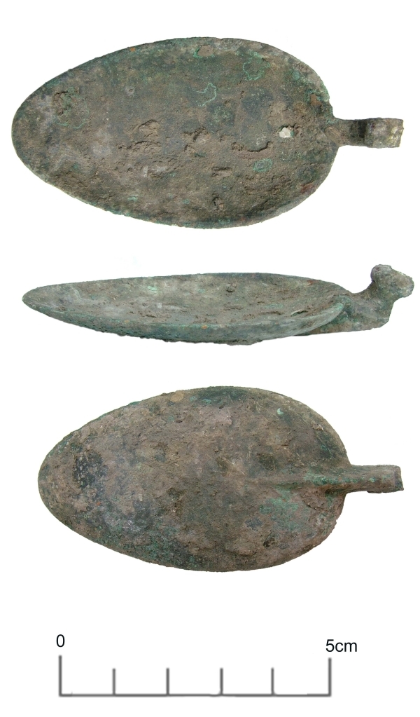
Just how old are spoons? A spoon (apart from a knife) is probably the oldest utensil known to man, being used to scoop up food to eat and for mixing and measuring. The oldest spoons were probably just scoops made from shells, later developing into purpose made scoops with handles and made from wood and bone. Some of the earliest known spoons with handles dating from around 1300 BC have been found in ancient Egyptian tombs and are carved from ebony and ivory.

Our copper alloy spoon bowl, found in a Roman building at Broadstairs in 2004, is much younger, dating to the late second century AD and is without its handle. It was found associated with an oven on the floor of the cellar in a thick sooty deposit that also contained pottery, iron nails, rings and fittings as well as a Roman military belt buckle suggesting that old timber and even clothing was being used to fuel the fire.

You can read more about the site in Moody, G. 2007. Iron Age and Roman British Settlement at Bishop’s Avenue, North Foreland, Broadstairs. Archaeologia Cantiana CXXVII

VM_365 Day 22 – Margate Epigraphy

Many layered memories of Margate

A palimpsest of texts inscribed on the cliff face west of Margate. Who is Violeta, what was special about 1935, is I Steve a vision of the future?

This is just a few metres of an immense  running inscription, unfolding a theatre of memory and an archaeology of seaside experience.  Will this record be pored over for its meaning in the future or are these human experiences as enduring as the chalk they are written on?

Go and see it one day, see who you can find.

VM_365 Day 21 – An ancient past no one can see

Image of excavations at Lord-of -The Manor Ramsgate in 1976
Excavations at Lord-of-The-Manor Ramsgate in 1976, revealing the ancient landscape hidden by the plough

The Trust for Thanet Archaeology is an educational charity and one of its aims is to teach people about Thanet’s very important past history, which has been revealed through archaeological investigation.

One of the problems faced by the Trust is that much of our archaeology remains hidden from view under the wide expanses of agricultural fields that cover the Island. Take a close look at the area surrounding the excavation in the image, which is as flat and featureless as any field could be. Yet below the thin covering of top soil are the remains of a prehistoric site, formed of several succeeding ring ditches that were used and adapted for many different ceremonies and burials from the Beaker period to the Bronze Age.

The importance of Thanet’s landscape in the past partly derived from the fertile soils  and relatively warm weather, where the climatic conditions on this south east coast were not dissimilar to those of the near continent. For prehistoric peoples, the interaction with the coastal areas of Britain were not such a great leap as they would have been if the conditions were closer to those in the north of the the British Isles. The combination of close European connections, openness to innovation in culture and the fertile landscape, led to the formation of a dense record of past settlement that has been discovered in the Isle of Thanet.

Sites like the Lord-of-the Manor ring ditches shown in the image tell the earliest part of Thanet’s story , but their significance can really only be comprehended by looking at the records, reports and images that remain from the archaeological efforts to discover and investigate them. The intensification of agriculture from the medieval period onwards levelled the remains of the settlements of preceding generations, until only the truncated remnants lay buried under a swathe of plough soil, covering miles of flat ploughed fields.

Over time, each  generation has done its best to prosper in the soil. For many centuries much of the landscape was in use as grazing land and we have archaeological evidence that ancient barrow mounds and ditches remained standing in the landscape in the Roman period. As late as the 19th century earthworks and mounds remained in the Lord-of-the Manor area of Ramsgate, where today’s image was taken during excavations in 1976.

VM_365 Day 19: Saxon Silver hooked tag

Today’s image from the archive is of a ninth century Saxon silver hooked tag excavated in 1991 from a ditch at Sarre. The hooked tag measures 2.5cm high and 1.5cm wide and is a crude design of a Trewhiddle style bird in niello inlay.

Decorated hooked tags are known from the seventh century and continue until the late Medieval period probably because they could be used multiple ways. The holes at the top of the plate were for fixing to cloth or leather and would have been used in a similar way to hook and eye fastenings. Similar tags have been found in association with coin hoards and may be purse fasteners, others have been found in graves where they may have been attached to garters.


VM_19

VM_365 Day 18: Celluloid. Huh. What is it good for?

Extracting ancient images. We will say that again.

VM 18


Today’s VM 365 image follows on from a theme set by yesterday’s image, which was scanned from an old colour slide dating from the early 1980’s. The image was cleaned up for a new digital generation more experienced with looking at images sent instantly to their phones than delivered using a hot light bulb to the wall of a village hall. Today’s picture is of one slide archive from the 1970’s and early 80’s, full of many hundreds of images that are locked in celluloid slides.

Even though many of these slides were scanned in the early 2000’s, technology moves on and our ability to enhance and manipulate the images progresses every year allowing them to be available and potentially more accessible over time.

Many of the images we will present in the future for VM 365 will come from this valuable resource.