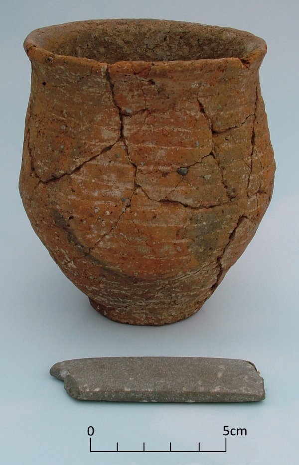
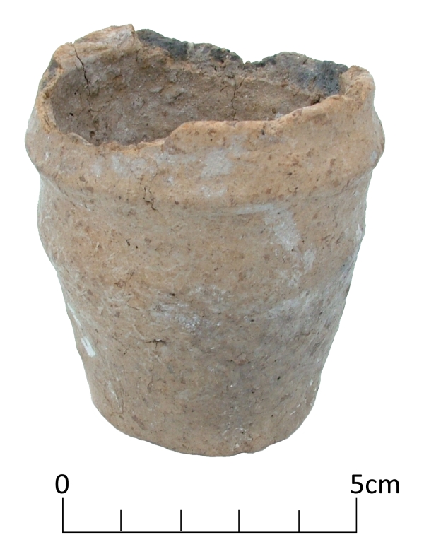
Today’s image is of a stone archer’s wristguard accompanying a Beaker vessel found in an Early Bronze Age round barrow at St Peters, Broadstairs.
The wristguard, made from non local mudstone, and Beaker were found in excavations at the St Peter’s Refuse tip site between 1969-1971 where an important Anglo Saxon cemetery was also excavated.
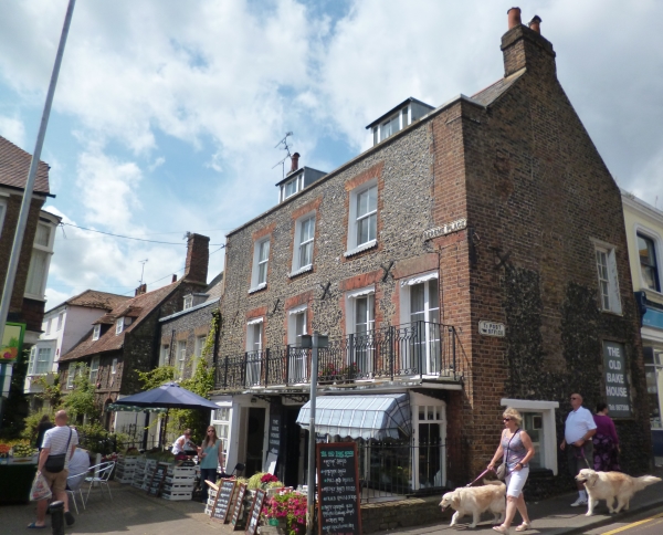
This very attractive historic little corner situated just off Broadstairs High Street is Serene Place and the buildings within it date from the 17th to the early to mid 19th century.
The Serene House, the second building from the left is the earliest in the group and seems to have originally been constructed around 1603, probably as a timber framed building. It was refronted in the 18th century when it was faced with flint with red brick dressings. The building has a beamed interior and an inglenook fireplace.
Bradstow House, the building on the corner of Serene Place and the High Street, is early 18th century and was originally constructed as a single house but is now a house and the Old Bake House and cafe. The shop front that you can see was constructed in the 19th century.
Castle House, first from the left, and Lancaster House, third from the left are both Georgian. Castle House, built in the early 19th century is a three storey brick building with a basement. Lancaster House, a 2 storey townhouse faced in flint, was built in 1824 for Samuel Lancaster after whom it was named.
The tithe map of Saint Peter published in 1842 shows these houses facing onto an open area of land. After 1842 this was infilled with a terrace of houses facing Serene Place named Raglan Place. Only 3-5 Raglan Place survive of this early 19th century terrace.
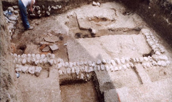
Basement room, almost all that survived of a Roman Villa at Stone Road, Broadstairs.
The North Foreland promontory is separated from the downland slopes further to the south by a dry valley, which falls to the cliff line near Stone Bay. In recent time a cutting was made through the cliffs, forming steps and a steep ramp to reach the present shore. In the Roman period there may have been a more gentle slope through the base of the valley, leading to a natural bay located further to the east, which has since been destroyed by coastal erosion.
In the 1920’s O.G.S, Crawford, the great pioneer of British archaeological survey, noted that earthworks and Roman pottery had been found on patch of open downland at Stone Gap , to the north of Broadstairs. No further investigation of the site seems to have taken place before the growing suburbs of Broadstairs eventually enclosed the location within the garden of a bungalow. No attention was drawn to the record of the Roman finds made by Crawford again.
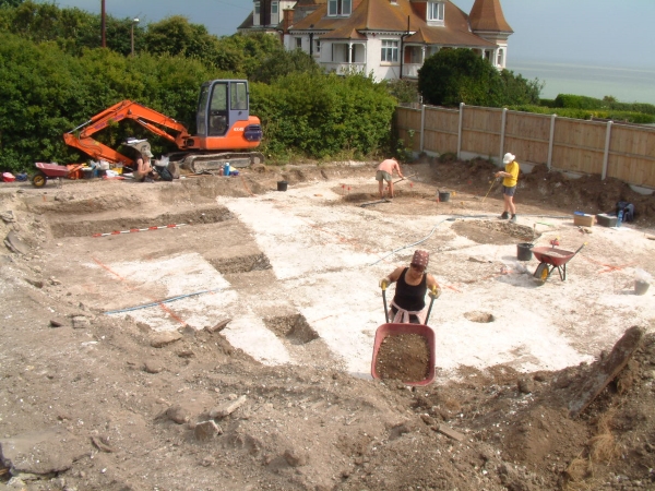
In 2004, the large garden of the bungalow was divided and part was sold to be the location of a new house, to fronting Bishop’s Avenue near its junction with Stone Road. In an archaeological evaluation trench on the site a few scraps of painted plaster were found, with a few Roman and late Iron Age pottery sherds, along with a row of rounded flint cobbles which appeared to be part of a wall. A larger area excavation had to be carried out, which was not an easy task in the very limited space.
Below the deep layer of garden soil that had been distributed over the site to level it, the remains of the basement of a Roman building, an overview of which is shown in today’s image, were uncovered.
The basement had been cut into deep drifts of plough soil which had accumulated on the sloping valley side. The pottery sherds within this soil were almost exclusively of Iron Age date, probably debris from the extensive North Foreland settlement which lies only a short distance to the north of the site. The sides of the rectangular cutting into the soil were lined with large water rolled flint cobbles, bonded with a chalky clay paste.
Many more small painted wall plaster fragments were found in the thin layer of demolition deposits that had been trapped within the rectangular area enclosed by the rounded cobble walls. The lower layers of flooring were revealed to be thick spreads of beaten chalk of variable depth, which sealed two infant burials in one area. The floors seem to have been repaired a number of times in association with the construction and then abandonment of a series of small kilns, which had been fuelled by burning chaff, the fibrous husks separated from harvested grain.
In the latest floor surfaces two more substantial kilns or ovens had been built, the soot from the latest was spread over the clay of the last floor surface. Within the soot a military belt buckle and other small metal items including a spoon, were found, suggesting that clothes or timbers with fittings still attached had been used to fuel the oven.
The Stone Road building provides an intriguing glimpse of a moment in history which can not be fully narrated, but nevertheless generates many associations and speculations. With the limited access to the space in the area of the building and the heavy toll of erosion and damage from subsequent construction work, further archaeological investigation in the future may never be able to answer the many questions raised by this remarkable discovery.
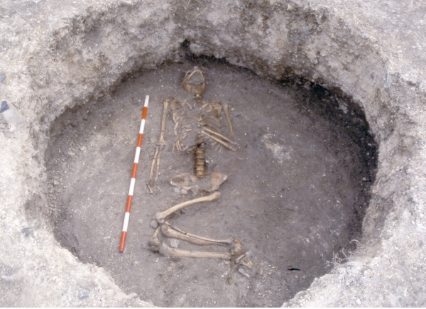
Burial of a woman in the fill of an Iron Age grain storage pit at North Foreland, Broadstairs
The VM_365 image from our archive today is of a burial found in Broadstairs in 2003 in excavations that were carried out before a new housing estate was built in the grounds of the former St Stephens College, which is located on the crest of the high chalk promontory of the North Foreland, north of Broadstairs.
Broadstairs has a particularly high concentration of archaeological sites dating to the middle and later Iron Age, most located mainly on the slopes of the undulating downland that surrounds the present town and Viking Bay. In the Iron Age the coastlines would have been very different as coastal erosion has caused the cliffs to advance to the west. The line of cliffs and the bays that were formed between them would have been located much further to the east than they are today.
Several sites have produced evidence for timber structures, reconstructed from the truncated remains of post holes that have survived in the chalk geology. On the long North Foreland promontory ditched enclosures, buildings and even a significant late Iron Age coin hoard suggest that the area was densely settled and relatively prosperous.
Large round pits, sometimes with undercutting edges are typical of the Iron Age settlement sites excavated in the chalk lands of Kent and the South of England and several have been found in the Broadstairs area. They are commonly interpreted as storage pits, where grain could be sealed away underground and kept for later use. The burial pictured in the image today was found in the fill of one these large pits. At the base a thick deposit of charred cereal grains including barley, oats and spelt and emmer wheat was found among large lumps of chalk plaster, strengthened with timber stakes, which appears to have been part of a lining for the pit.
Once the pit had served its original purpose it was filled up with soil containing pottery and other settlement debris. The burial seems to have been laid on its back, on the surface of a pit made by cutting down the original fills of the pit to about half its original depth. Analysis of the skeleton showed it to have been an adult female and at her neck were three blue beads made of a from of early glass called faience , objects made of faience were traded throughout Europe as a luxury item.
Several similar burials have been found on archaeological sites at South Dumpton Down and the Seven Stones estate on the southern side of Broadstairs. The significance of the use of the former storage pits is a matter of debate, perhaps there was a symbolic association around the idea of storage below ground, or perhaps the pits were mistaken for earlier burial mounds and the association was with earlier cultures or ancestors. No one can be sure as we have no written evidence that records the ideas and beliefs of the people who lived at this time.
An unusual Early Bronze Age miniature collared urn discovered in the North Foreland area of Broadstairs is shown in our image for VM_365 today.
While building a house on a plot in North Foreland Avenue in 1979, workmen rescued the tiny vessel from a pit after they had uncovered the ring ditch of a round barrow. Rescue excavations on the site traced part of the ring ditch as well as human remains from a later period within the same site, representing at least five Iron Age burials.
The Collared Urn, which has an estimated date range of 2000 – 1500 BC, is one of a few examples of tiny versions of these vessels that have been found in Britain. The urn may have been placed in the central burial of the barrow, which had already been built over when archaeologists investigated the site.
Miniature vessels like this may be token representations of their full size counterparts, used as a substitute in certain cultural conditions, or they may represent the smaller end of a range of functional vessels, collared cups rather than urns.
Yesterday we introduced you to Howard Hurd, Thanet’s first scientific archaeologist. Today we show you some of the archaeological work carried out by Hurd at Dumpton Gap and South Cliff Parade, Broadstairs.
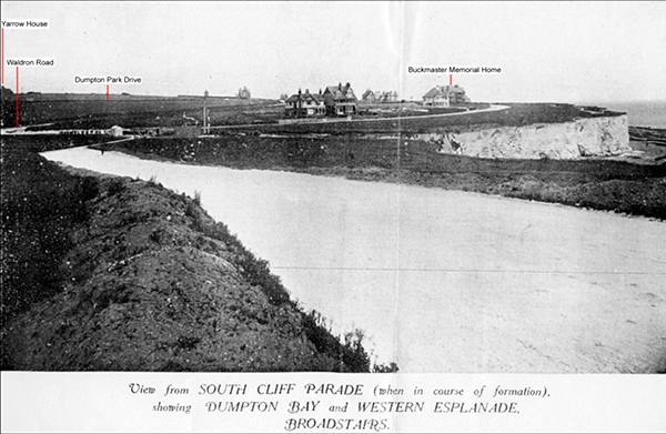
The image above, taken c. 1907 for a land auction catalogue, shows what Dumpton Gap looked like as the new estate was being laid out along the cliff top between Dumpton Gap and Broadstairs. The view is taken from South Cliff Parade, near where the entrance to Seacroft Road is now.
In the background the buildings that were already constructed are marked; Buckmaster Memorial Home, along the Western Esplanade and Yarrow House (now East Kent College) on the edge of the picture. The beginning of Waldron Road and Dumpton Park Drive are visible in the background. At the top of the cutting leading down to Dumpton Bay you can see the buildings associated with the entrance to a submarine telegraph.
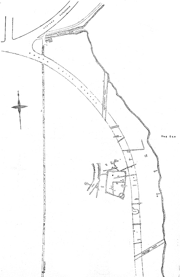
In his capacity as Town Surveyor and Engineer, Hurd recorded the archaeological features that were exposed during the work and published reports on them. You can see from the meticulous plans that he published in 1913, that many archaeological features were revealed when the roadway was stripped. The features include a small prehistoric round barrow, pits, ditches and the settlement enclosures which he referred to as a Late Celtic Village.
Excavations carried out at Seacroft Road by the Trust for Thanet Archaeology in 2006 allowed us to revisit a small part of the area that Hurd recorded. Our plans of the site overlaid almost perfectly with his and our excavations were able to establish that occupation on the Late Iron Age site, which Hurd referred to as ‘Late Celtic’, continued into the Roman period. Roof tiles, stone and pottery of Roman date suggest that a building was located in the area, perhaps the one described by the Reverend John Lewis in his History of the Isle of Thanet, written in 1736, as being present in this area.
Further reading:
Hurd, H. 1909. On a Late-Celtic Village near Dumpton Gap, Broadstairs. Archaeologia (Second Series) Volume 61 Issue 02, pp 427-438
Moody, G. A. 2008. The Isle of Thanet from Prehistory to the Norman Conquest. The History Press: Gloucester.
Howard Hurd was Thanet’s first scientific archaeologist. In 1897, at the age of 32, he was appointed Surveyor and Water Engineer to the Urban District Council of Broadstairs and St Peters in charge of the water supply and other services. His work on the new estates being constructed as the town expanded brought him into contact with many archaeological discoveries. The local construction workers were aware of his interest and brought things they had found to his attention.
Hurd produced comprehensive reports of his discoveries with accurate plans, illustrations and photographs. He recorded archaeological discoveries of Bronze Age Barrows at King Edward Avenue, Valletta House and Dumpton Gap; Roman cremation urns at Rumfields Road and the Anglo Saxon cemetery at Valletta House, now Bradstow School. In 1911 he was one of the founder members of the Broadstairs and St Peter’s Archaeological Society along with Miss Bartrum, the owner of Valletta House.
His work was the first accurate, scientific archaeological recording carried out on Thanet that still stands the test of time today.
Find out more by reading:
Moody, G. 2008. The Isle of Thanet from Prehistory to the Norman Conquest. The History Press: Gloucester. 19-20.
Hurd, H. 1913. Some notes on recent Archaeological Discoveries at Broadstairs. Broadstairs and St Peter’s Archaeological Society
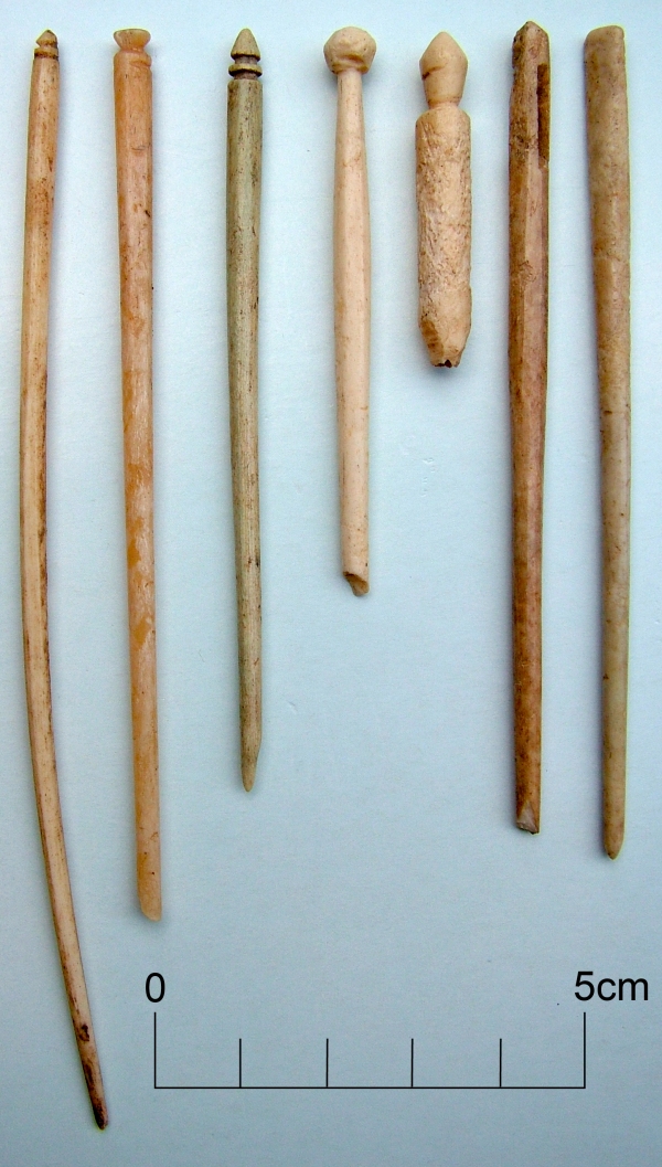
Bone and ivory pins, personal items from a Roman Villa
While some of these bone and ivory pins are undoubtedly personal objects, used as hair pins and possibly for fastening clothes, these fragile objects from the Roman Villa at Minster in Thanet may also reflect the enormous variety of crafts and industries that were carried out in and around the Villa.
Some pins and broken fragments of pins which have eyes through in the upper part of the shaft, are probably large needles. Being made of such a brittle material they were perhaps used to stitch together soft woollen cloth, perhaps in a process associated with weaving, or perhaps they may have been used to make and mend nets.
Similar straight wood and ivory pins with their carefully carved terminals can be found among the bobbins of lacemaker’s tool kits in the present day, although there seems to be no direct evidence of Roman lacemaking.
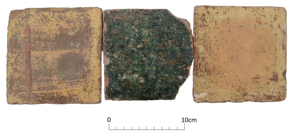
Today’s image shows three nearly complete floor tiles from the site of one of the lost medieval parish churches of Thanet; All Saints, Shuart. The site was excavated by the Isle of Thanet Archaeological Unit in 1978 under the direction of Frank Jenkins, assisted by Dave Perkins and site assistants from the Manpower Services Commission.
These plain glazed floor tiles were found in the demolition rubble of the latest phase of the church and are of Flemish manufacture dating to the late 14th to 15th centuries.
The Church was originally established in the 10th century, along with St Nicholas at Wade, as dependent chapels of the Church at Reculver. All Saints was altered and expanded in the 10th-11th centuries, 12th century and again in the 13th century. By the mid 15th century the church was in ruins and it was eventually demolished by about 1630.
The reason for its decline may be that the parishes of St Nicholas at Wade and All Saints were combined in the early 14th century and it later became too much of a financial burden for the parish to support two churches; All Saints was neglected in favour of St Nicholas at Wade.
Further reading:
Jenkins, F. 1981. The Church of All Saints, Shuart. In Detsicas, A. 1981. Collectanea Historica: Essays in Memory of Stuart Rigold. Kent Archaeological Society; Maidstone. 147-154.
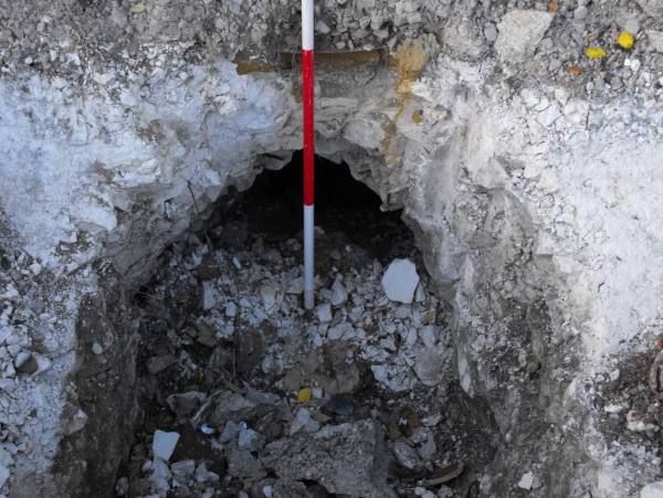
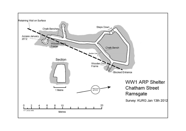
This intriguing picture shows the entrance to a First World War air raid shelter which was exposed in 2011 when a new supermarket at Chatham Street, Ramsgate was being constructed.
Bombing raids from Zeppelins and cross channel shelling had affected Thanet, but it wasn’t until 1917 that the Island was targeted by German Gotha bombers. Many of the air raid shelters on the Isle were dug into the chalk bedrock at this time.
The Chatham Street shelter was surveyed by Rod LeGear, assisted by other members of Kent Underground Research Group in January 2012. The survey, shown below, revealed that the tunnel included benches cut into the chalk and had been lit by simple candles some still remaining as stubs in niches in the wall.
An Ice factory occupied the site from around 1907 and this shelter was probably dug as a refuge for its employees in 1917 in response to the Gotha bombing raids.
Further Reading:
LeGear, R. 2012. Underground Thanet. Trust for Thanet Archaeology: Birchington.