Category Archives: VM_365 Project

VM_365 Day 70. Can’t take a class to a site? Take the site to the class!

Learning to record a site with our mini-excavation in a box

On VM_365 Day 70 we have an image of aother of our resources for teaching the principles of archaeological recording. Understanding the recording process is essential for grasping how archaeologists build up the story of the past from finds and paperwork. Another dimension is added to the finds and images from our Virtual Museum when the archaeological excavation process behind the discoveries is familiar to the audience.

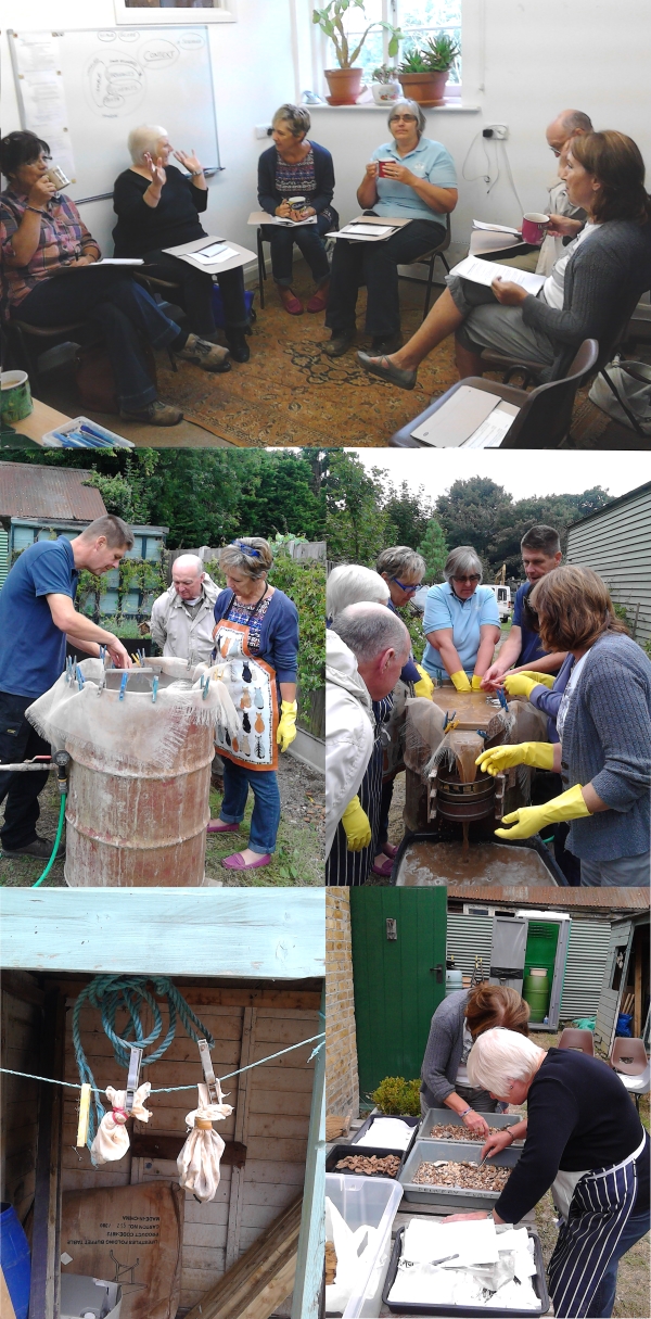
It can be useful to take people to an excavation so they can spend time learning how an archive is built up for a site by planning, drawing sections and recording contexts. But, many of the excavations that archaeologists carry out now are in locations like building sites that are not easily accessible, especially to very young, elderly or disabled people.  When we want to explain the processes of recording, it is not always possible to take a class on to a site or hold an extended workshop on a busy excavation.

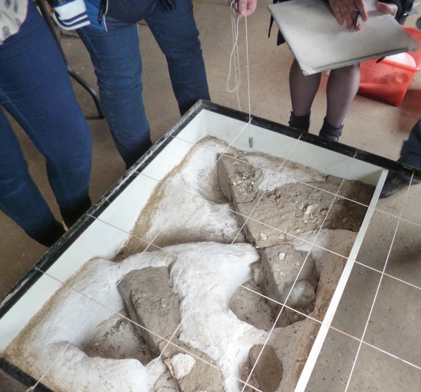
So the Trust solved the problem by creating a Site in a Box which can be used indoors to teach archaeological methods with plenty of time to practise. Using our experience of the archaeology of the area, and a certain creative flair, we have reproduced an authentic slice of prehistoric Thanet  to work on at our leisure

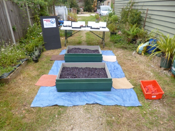
While our Dig and Discover activities that featured in VM_365 Day 68 are useful for teaching the principles of finds recovery and the materials that are commonly investigated by archaeologists, the Site in a Box can be used more effectively to gain an understanding of how the recording of archaeological excavations creates the information that is needed to understand the context of the material that is recovered.

We hope that our Site in Box will help as many people of possible understand the background to the finds and images that we post in the VM_365 project.

VM_365 Day 69 Environmental Archaeology Workshop Day – September 6th 2014

A medley of images from our environmental archaeology workshop with IOTAS

Following a successful community archaeological excavation at Lord of the Manor Ramsgate in 2013, the Isle of Thanet Archaeological Society have been keen to learn more about the post excavation process so that they can progress with writing up and publishing their results.

The Trust has been able to help out with planning a series of workshops, sharing our professional expertise and our resources to introduce the next steps that follow beyond the field work of an archaeological dig.

Today we organised a workshop on environmental archaeology with a practical session in processing samples using our flotation tank. We took the opportunity to run through some stored samples from some interesting contexts from earlier sites which had been put into storage.

One sample processed was the contents of a 3rd century cremation vessel found at a site in Westgate where fine slivers of burnt bone were recovered from the residue, proving that at least a small amount of the cremated remains had survived the heavy disturbance that the site had suffered in later years. More will be learnt form the fine organic material that was floated from the sample, which was hung up to dry in the September sun and will be processed in a few days time.

The day proved to be both educational and sociable with the unexpected provision of cakes and snacks to supplement the flow of tea and conversation on archaeology and the environment.

VM_365 Day 68. Dig Boxes!

VM 68

Our Dig and Discover boxes went on a journey to Lympne, near Hythe today. They will be used on Sunday 7th September by the newly formed Studying History and Archaeology in Lympne group, SHAL for short, at their stall at the Lympne Village Fair and Dog Show to interest people in archaeology and, hopefully, gain new members for their group.

We took the opportunity of being able to set up the Dig and Discover resources to record the process of setting it out and listing the equipment that we use, with a view to producing a How to Guide for other people who may want to borrow the equipment, or set up their own Dig and Discover package.

VM_365 Day 67 17th century Malthouse, King Street, Margate

VM 67

Today’s journal entry is inspired by Margate Brewery’s recent blog post about their future new premises at the High Street, Margate where they have established a 17th origin for their building which has been associated with beer, wine and spirits for most, if not, all of its lifetime.

While we are no experts in these kinds of structures, this made us think of other buildings in Margate connected with brewing and probably one of the least know standing buildings is a structure known as The Barn which is located to the rear of the Tudor House on King Street. This flint structure, shown on the right hand side of the picture, partly rebuilt in modern brick and heavily altered over the years, has been identified as a purpose built Malthouse constructed in the 17th century and used to malt barley to be used in the brewing of ale.

The Reverend John Lewis published an interesting passage in 1736 about malting and brewing in Margate:

‘…Malting is another Branch of the Trade of this Place, which was formerly so large, that there about 40 Malt-houses in this parish. But this trade also is now gone much to decay; tho’ certainly here might be the best Malt in England, the barley which grows here being so very good, and the Land naturally so kind for it. The Malt, it seems, here made, having formerly been very coarse for the Use of the Distillers, it has so much lost its Credit, that the present Maltsters find little Encouragement to make their Malt fine for a London Market, where they are almost sure to be out-sold by the Hertfordshire and North Country Malt-men, whose Malt bears a better name

About 40 Years ago, one ____Prince of this Place drove a great Trade here in brewing a particular Sort of Ale, which, from its being first brewed at a Place called North-down in this Parish, went by the Name of North-down Ale, and afterwards was called Mergate Ale. But whether it is owing to the Art of brewing this Liquor dying with the inventor of it, or the Humour of the Gentry and People altering to the liking [of] the Pale North Country Ale better, the present Brewers vend little or none of what they call by the Name of Mergate Ale, which is a great Disadvantage to their Trade ‘

(Lewis 1736, 134)

The breweries being established in Margate are not so much a new phenomenon, more a return to an old local tradition of brewing fine beer.

References

Austin, R.  2014. Tudor House, Margate. In Canterbury’s Archaeology 2012-2013. Canterbury Archaeological Trust, 21-22

Lewis, J. 1736. The History and Antiquities as well Ecclesiastical as Civil, of the Isle of Tenet, in Kent. Second Edition (Reprinted by Michaels Bookshop, Ramsgate)


VM_365 Day 66 What’s in a dish?

VM 66

Today’s image shows a handmade, straight sided dish that was found in a Roman grave at Ramsgate. The dish, made from grog and quartz sand tempered fabric with a few shell inclusions, had been heavily used before it was placed in the grave at the feet of a young woman aged between 18-25 years along with two other vessels.

There are many questions we would like to ask when we find objects in these circumstances:

Did this vessel belong to the occupant of the grave or to a family member? What did she use the dish for? Did she use it for eating from or did she use it in cooking, perhaps to make pies* or other meals? Were the knife marks in the base made by her?

Despite all our efforts archaeology may not be able to answer these questions from the evidence that remains.

*Pies are mentioned in a collection of cookery recipes, Apicius, believed to date from the late 4th to 5th centuries.

VM_365 Day 65 When is a coast not a coast? Beware of the changing landscape.

Bronze Age pit lined with woven timbers

For Day 65 of VM_365 the image shows one of the most important sites in Thanet for understanding how the changing landscape can throw up problems for archaeologists when they are interpreting features and finds in the landscape.

In the centre of the picture is a pit under excavation on the foreshore at St. Mildred’s Bay on the north coast of Thanet. Against the back edge  of the pit can be seen the thin  horizontal and vertical timber rods that form a woven lining to the pit, similar to a woven basket closely fitting the size of the pit.

In the dry chalk landscape of Thanet, pits and other features of this age are generally filled with sequences of chalky soils or clay and silt deposits, with no hint that any organic deposits ever existed. In other parts of the country where archaeological features have been found in waterlogged conditions, many examples of the use of organic materials and even complicated carpentry from sites of the same date have been recovered. Because the conditions in Thanet are not good for preserving organic material, all trace of this part of the record has been erased.

If recording is carried out with care and attention, archaeologists can deduce that such material may once have been present, lining pits and forming structures that are now undetectable apart from the holes that were dug for them or the material that eventually replaced the organic deposits. The positive aspect of the discovery of sites on the foreshore in waterlogged conditions has demonstrated that the absence of this material elsewhere is due to the conditions of preservation not the absence of this material in the period.

The negative aspect is the interpretation of the location of these sites at the time they were created. Thanet’s land mass has been diminishing year after year as rising sea levels have covered land and the sea  has eaten away the chalk to form the cliff line and the flat platforms of the foreshore. Sites like the one in today’s image were not on the coast when they were created, they may even have been some distance away from the coast and we must be careful not to give an undue significance to the present coastal location of the sites when they had no bearing on the settlement at the time.

It was a matter of good luck that some archaeological features were preserved  in the platform cut by the waves around the coast, leaving remnants behind in waterlogged conditions to give us an idea of what life was like on dry land four or five thousand years ago. It is clear from evidence like this that the study of the dynamic landscape and attempts to understand and represent the changes on maps are an important part of the archaeologists tools for interpreting past societies.


VM_365 Day 64 How landscape affects everyday objects

Flint tempering in Late Bronze Age pottery fabric

If you look carfeully at this close up of the fabric of a  Middle Bronze Age pottery urn from Ramsgate you can see two aspects of human interaction with the landscape which are preserved at a relatively small scale in an everyday object.

In the centre of the picture the finger prints of the potter have decorated the surface of the vessel, but the fabric of the clay that was shaped by the maker was made from a combination of the local clay, stiffened with inclusions of fragments of crushed burnt flint which was also taken by the potter from the local landscape.

The material was worked by the potters into the common forms that were part of their culture but the feel of the material was a direct reflection of the immediate landscape of the potter. Each region may have shared common vessel types, which could be transmitted through examples and ideas, but the materials the vessels were made from were gathered locally and were usually distinctive in their fabric which were rooted in the  local landscape.

VM_365 Day 63 Archaeology in a Landscape

Bronze-Age round barrow on hilltop overlooking Pegwell Bay

How does an archaeological site reflect its landscape? This image for VM_365 Day 63 shows how important location within a landscape is for the choices that are made on where to live, work and celebrate.

Bronze Age round barrows like this one at Ramsgate were formed by digging a circular ditch into the hard chalk of the hillside to create a mound in the centre from the spoil from the ditch. Very frequently, but not in every case, the central mound covered the burial of an individual which was itself laid in a chamber created by cutting a rectangular pit into the chalk.

But what motivated the choice for the location of each round barrow? This image contains one answer to this question in the vista over Pegwell Bay which can be seen  beyond the section of the ditch revealed in the trench. From this position the land from Deal,  the  eastern mouth of the Stour and the mouth of the valley  of the Wantsum, sweeping through to the northern side of Pegwell Bay where the open sea was visible beyond the land.  On a clear day the cliffs on the coast of France can also be seen on the horizon from this location.

In general, similar Bronze Age funerary monuments in Thanet have been found in commanding locations on the convex slopes of hillsides and valleys which the undulating chalk downs of Thanet  possess in abundance. In each location the commanding view demonstrates that the position was carefully chosen and surveyed to assess the suitability of the site.

Before we interpret the motives behind such choices of position, we need to consider  that the landscape has changed from that of the Bronze Age through coastal erosion and sea level rises. The Bronze Age barrow burial rite also lasted some centuries and within the monuments recorded we need to consider what influence the  choices of earlier people had as time passed.

Many of the best sites may have been taken at an early stage, or perhaps the best locations were identified and rationed in some way that was determined by the culture and contemporary ideas of rights and status. To date there has been little evidence that barrows were partially overlapped to usurp the space taken by an earlier monument, although we do have evidence that the ditch of an earlier barrow was re-excavated and trimmed, possibly to accommodate a new burial. Perhaps it was acceptable to re-use a barrow, respecting and associating a new person with the personality and status of the earlier burial,  but it was not acceptable to damage an earlier barrow and erase the memory of the significance of the earlier burial.

The landscape seems to have had a deep resonance in the culture of Bronze Age Thanet, although we can only work out the ways these were turned into cultural forms by reasoning from our data on the location of features within the landscape and considering the logic of the placement of the sites within the space and land forms that were available. In short, archaeology loses an important dimension if context within its landscape does not form part of the archaeological investigation that is applied to it.

VM_365 Day 62 The shape of the land shapes the culture

Topographic map of the Isle of Thanet
The distinctive landforms that shape Thanet’s history

The map shown here for VM_365 Day 62 is of the underlying shape of the landcape of the Isle of Thanet, a factor which has shaped its history and culture over many centuries.

The shaded relief of the map was created using height data taken by the NASA space shuttle as it orbited the earth. Unlike yesterdays image which showed the locations of all the discoveries of archaeological remains from a particular  historical era, the Roman period, this map shows the enduring structures of the Isle of Thanet’s landscape.

Modern development has sometimes disguised the natural shapes of the chalky slopes and valleys that divide up the space that has been occupied in Thanet for over six thousand years, but with careful observation you can still recognise its major features, although less so as new housing estates and roads change the natural rhythms of the landscape each year.

If you are out and about on the Isle, look around and see how the land rises and falls and in places gives amazing views over the slopes and to the sea.  Observe how the various towns and areas occupy particular slopes or are separated by valleys.  Follow the routes of the Islands older roads over the ridges and up the slopes of the network of valleys that underpin the landscape.

The ancient inhabitants of Thanet were acutely aware of the shape of their landscape and chose the sites of their settlements, ceremonial sites and burial grounds with their location on specific landscape features in mind. Lines of sight between locations were important, as were vistas where large distances could be see all around. Access to resources or to the sea and the flat grounds at the top of the hill shaped the way the Island’s people moved around. Sometimes the relative effort of getting from one place to another dictated the way settlements grew up around the area.

To understand the distribution of sites in one particular period we need to understand that the one relatively constant factor in the development of  society over time was the influence of the physical shape of the land. Understanding the shape of the land can explain the choices made when settling the landscape as well as the changes that happened over time.


VM_365 Day 61 A map is more than a sum of its parts

Reconstructed map of Roman Thanet
A map of Roman Thanet imagined

Today’s image for Day 61 of the VM_365 project shows a map of Roman Thanet that was produced to accompany an exhibition called Roman Thanet Revealed, which was curated by volunteers and was on display at the Powell-Cotton Museum in Birchington from April to October 2011.

The map showed an up to date list of major Roman sites that have been identified on Thanet, including the new buildings that had recently been discovered at Upton, Stone Road and Fort House, Broadstairs (shown as Bleak House on the map), as well as the villa at Minster. The map was created to illustrate the locations of the various items on show and to place the discoveries into the context of the networks of roads, towns and forts that would have formed the central places in the Romano-British community.

A map like this serves a number of purposes. It records the location of the discoveries that have been made by archaeologists in specific locations, but it also allows connections to made between the sites and the landscape that they stand in which helps to create a narrative of similarities and differences within the period and to suggest interactions between types of sites and locations .

Recent research has shown in detail the changes that must have taken place in the coastline of Thanet since the Roman period and this map suggests where the Roman coast line might have been. Archaeological evidence in the form of recently rediscovered records and finds from a Roman cremation burial and structure from Boxlees Hill within the channel, show clearly that the  Wantsum Channel which separated the Isle of Thanet from the mainland of Kent was not as open and navigable as was once thought.  It is shown in the map with a wide margin of tidal silts with only the central channel open to the passage of ships.

Several recently published histories of Roman Britain have underestimated the density of settlement in Thanet in the Late Iron Age and Roman period, perhaps because some sites have remained unpublished and also because there is no permanent place to show and promote Thanet’s archaeological remains. As the Roman Thanet Revealed exhibition ended, our Roman history went once more into relative obscurity.

Further reading:

The ancient landscape of Thanet from the Ice Age to the Anglo-Saxon period is explored through a series of revealing historic maps of Thanet and new reconstructions based on geological and archaeological detective work in the book St. Augustine’s First Footfall which is published by the Trust for Thanet Archaeology.

The story of Thanet’s Archaeology from Prehistory to the Norman Conquest was explored by the Ges Moody of the Trust, using a series of maps and archaeological evidence. The Isle of Thanet from Prehistory to the Norman Conquest is available from all high street bookshops and online  book-sellers.

Download a higher resolution version of the map here