Category Archives: Post Medieval

VM_365 Day 322 Church of St Mary the Virgin, Minster in Thanet

VM 322
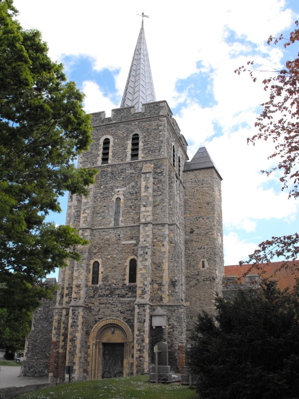
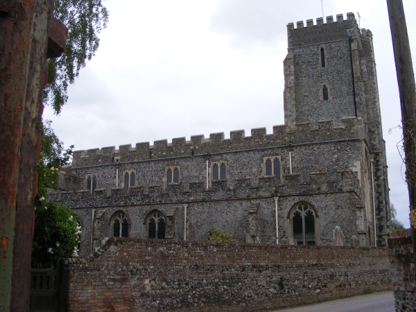
The image for Day 322 of the VM_365 project shows the eastern end of the church of St Mary the Virgin, Minster in Thanet.  The church was constructed with a mixture of water rounded flints and Thanet beds sandstone, with Caen stone , Reigate stone and Ragstone used as dressings in the medieval period. Bathstone was used to construct some of the 19th century elements.

A nunnery was founded at Minster in the late seventh century, which existed until it was destroyed by Viking incursions in the early 11th century. A church on or near the location of the present church would have been associated with the nunnery from its foundation. This church would also have been the main church in Thanet. Minster became the mother church to the four chuches of St John the Baptist at Margate, St Lawrence at Ramsgate, St Peter at Broadstairs and All Saints, Birchington.

The church and the manor of Minster was given to St Augustine’s Abbey, Canterbury in the early 11th century, when the monastic grange of Minster Abbey near the site of the present church which featured on Day 310 of the VM_365 project was established. The fabric of the present church originates in the Norman period, probably on the site of the earlier Anglo Saxon church building, although no evidence of the earlier church seems to survive in the the building.

The four churches  of Minster, St John the Baptist, St Lawrence, and St Peter were possessions of St Augustine’s Abbey, Canterbury unlike St Mary Magdalene, Monkton which featured on Day 317 of the VM_365 project and belonged to the estates of Christchurch Priory, Canterbury.

Parts of the early Norman church at Minster survive in the nave. The nave walls were pierced for arcades In the mid 12th century, to expand the space into newly constructed north and south aisles. In the late 12th century the western tower was added and in the lower sections of the tower reused Roman brick, probably originating from the nearby Roman villa at Abbey Farm, was used in its construction. The reused Roman brick can clearly be seen in the image above.

The eastern part of the church was rebuilt in the early 13th century, forming a cruciform church with large lancet lights.  The outer walls of the south aisle and east part of the north aisle of the nave were rebuilt and new windows were inserted in the early 14th century.

Crown-post roofs were built in the 15th century and at the same time the top of the tower was rebuilt with a  timber spire and a crenellated parapet. The stair-turret which can be seen on the right handside of the tower in the image above may also have been rebuilt at this time.

The church was heavily restored in the 1860’s, when the north aisle was completed as part of the restoration work.

References/Further Reading

Jones, H, and Berg, M. 2009. Norman Churches in the Canterbury Diocese. The History Press.

Tatton-Brown, T. 1996. St Mary Church, Minster in Thanet. Canterbury Diocese: Historical and Archaeological Survey. http://www.kentarchaeology.org.uk/01/03/MIT.htm


VM_365 Day 321 The parish church of St Nicholas, St Nicholas-at-Wade

VM 321
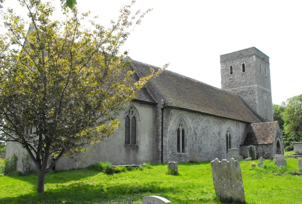
Today’s image for Day 321 of the VM_365 project shows another of our standing archaeological remain, this time the church of St Nicholas, St Nicholas-at-Wade, near Birchington.  The earliest church at St Nicholas was built in the late 11th century and parts of it survive in the lower portions of the west wall of the nave. The original church was constructed of large flints and sandstone from the Thanet Beds.

By the mid 12th century a south aisle was added to the nave and the arcade still survives. A north aisle may have been built at the same time but was replaced in the early to mid 14th century.

The church was a Chapel to Reculver until the end of the 13th century along with Sarre and Shuart. In the late 12th or early 13th century, a new east end was built with a new long chancel and two smaller chapels on either side. New windows were inserted into the chapels and the chancel in the late 13th to early 14th century; traces of the original east lancet windows are still visible in the walls of the east chapels where they are cut through by later windows.

The church was enlarged in the mid 14th century after it became a parish church in its own right in 1310 and as a result of an increase in the local population. Major rebuilding of the nave was carried out with a completely new north aisle and arcade constructed in Ragstone and Caenstone. A new tower was also built at the same time and a new south porch added sometime after. In the late 15th century, a new clerestory to the nave was built and the top of the tower, the aisles and porch were crenellated with knapped flint parapets.

In the mid to late 18th century, the south chapel was used as the parish school and its brick chimney stack is still visible. The chancel was repaired, the east wall rebuilt and the nave restored in 1875 and 1876.

While at face value parish churches may seem to be a steady and unchanging part of the fabric of Thanet’s village landscapes, they represent buildings that were constructed from the late Anglo Saxon period and continues to evolve as architecture until the present day. The story of these buildings is preserved in their visible structure if we take the time to read them properly.


VM_365 Day 320 The Tudor House, Margate

VM 320

Today’s image for Day 320 of the VM_365 project shows another of Thanet’s earliest standing buildings, the Tudor House at Margate. The house is of timber framed transitional type; a cross between the open hall house of the medieval period and the early modern house. The transitional house retained the high and low end arrangement of rooms that were seperated either side of the open hall  during the medieval period but did not have the open hall and was instead storied along thefull length of the first floor.

This high status timber framed building dates to the period around 1525-1550.  It was originally built for a wealthy household, possibly a farmer with additional sources of income and was heavily restored close to its original form in 1950 after having previously being subdivided into cottages sometime in the early to mid 19th century.

The Tudor house has a continuous jetty along the first floor and is  supported at the corners by dragon posts. It also has a jettied roof  supported internally by crown posts. In the western end of the building, where the service rooms were located, is a chalk and flint constructed cellar. The house was heated by two brick built chimneys.

The original windows, some of projecting oriel type, were glazed throughout, a conspicuous sign of the wealth of the owners of the building. Projecting Oriel windows can be seen on the ground floor in the image above.

Sometime in the 17th century an extension was added to the eastern end of the building to accomodate a larger stairway and the parlour ceiling was lavishly decorated with a plaster ceiling embellished with Tudor roses, grapevines and other motifs common at the time.

A 17th century malt house which featured on Day 67 of the VM_365 project was constructed to the rear of the building and its remains can still partly be seen  today.

The Tudor House is open to view by the public and is well worth a visit.

Reference/Further reading

Twyman, M and Beeching, A. 2003. The Old Tudor House at Margate. Margate Historical Society Local History Study Document Number One. Revised 2006.

Austin, R. 2014. Tudor House, Margate. In Canterbury’s Archaeology 2012-2013. Annual Review of Canterbury Archaeological Trust. pp 21-22.

VM_365 Day 317 Church of St Mary Magdalene, Monkton

VM 317

Today’s image for Day 317 of the VM_365 project shows the parish church of St Mary Magdalene, Monkton which is located at the western end of Monkton just off Monkton Street. The church is mainly built from flint and Thanet Beds sandstone with Caen and Ragstone used for the quoins.

The church of St Mary Magdalene was located within the Manor of Monkton which was given to Christ Church Priory, Canterbury in the late Anglo Saxon period. Two churches were documented in the Domesday Book of 1086 as being part of the Manor of Monkton, one of these probably stood on the site of the present church, which was constructed in the late 11th to early 12th century; the other is probably its dependent church located at Woodchurch, Acol. The church remained in the possessions of the monks of Christchurch until the dissolution.

The tower was constructed in the late 12th or early 13th century, around the same time that the church nave was increased in size by constructing a new northern aisle along the entire length of the north side.

In the late 14th or early 15th century major alterations were carried out to the church reducing it in size and adding new windows and roofs. These alterations may have been undertaken as a result of the reduction in population of the inhabitants of the area because of the Black Death. You can see an example of these alterations in the image above as a series of three of the five blocked arches along the northern side of the church, evidence of the demolition of the late 12th century extension to the nave.

The church was restored in the mid 19th century by C. A. Beazley; the chancel floor was raised, a new vestry constructed under the tower and the north porch was rebuilt and outer doors were inserted. Most of the interior fittings of the church date to this time.

References/Further Reading

Hasted, E. 1800.  The History and Topographical Survey of the County of Kent: Volume 10. Bristow: Canterbury pp. 253-264.

Tatton-Brown, T, 1993. St Magdalene Church, Monkton. Canterbury Diocese: Historical and Archaeological Survey. Kent  Archaeological Society.


VM_365 Day 263 Crampton’s Water Reservoir for Broadstairs

VM 263

Today’s post for  VM_365  Day 263 shows the disused reservoir located next to Crampton Tower, Broadstairs which was featured in yesterday’s VM_365 post.

The reservoir formed part of the Broadstairs waterworks built by Thomas Crampton in 1859.  Water was drawn from a deep well sunk into the chalk and was stored in the large reservoir covered by this impressive flint and mortar dome. The reservoir had a capacity of 380000 litres and water was pumped by a gas operated engine to a storage tank at the top of Crampton Tower, where gravity created enough water pressure to supply houses nearby.

The dome of the reservoir measures 8.8 metres (29 ft) in diameter and 5.4 metres (18 ft) high. It is constructed of brick inside and flint and daub on the outside of the dome although the upper part is constructed of brick with a chimney. On top of the chimney is a square ventilation box. Like Crampton’s Tower, the reservoir is Grade II listed and together they form a landmark in Thanet’s urban engineering heritage.

For more information about Thomas Crampton and Crampton Tower, visit Crampton Tower Museum in Broadstairs.

VM_365 Day 262 Broadstairs industrial archaeology landmark

VM 262
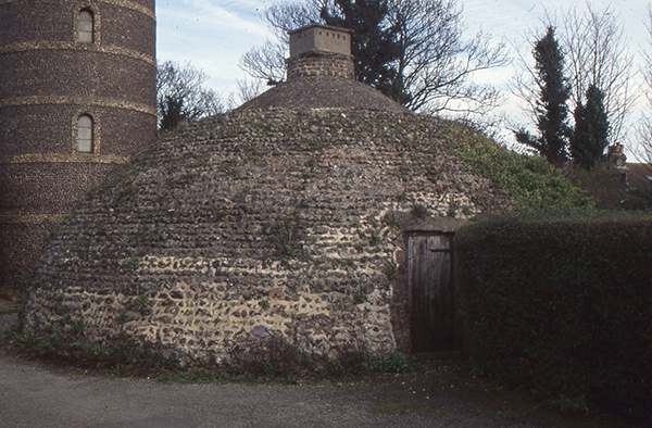
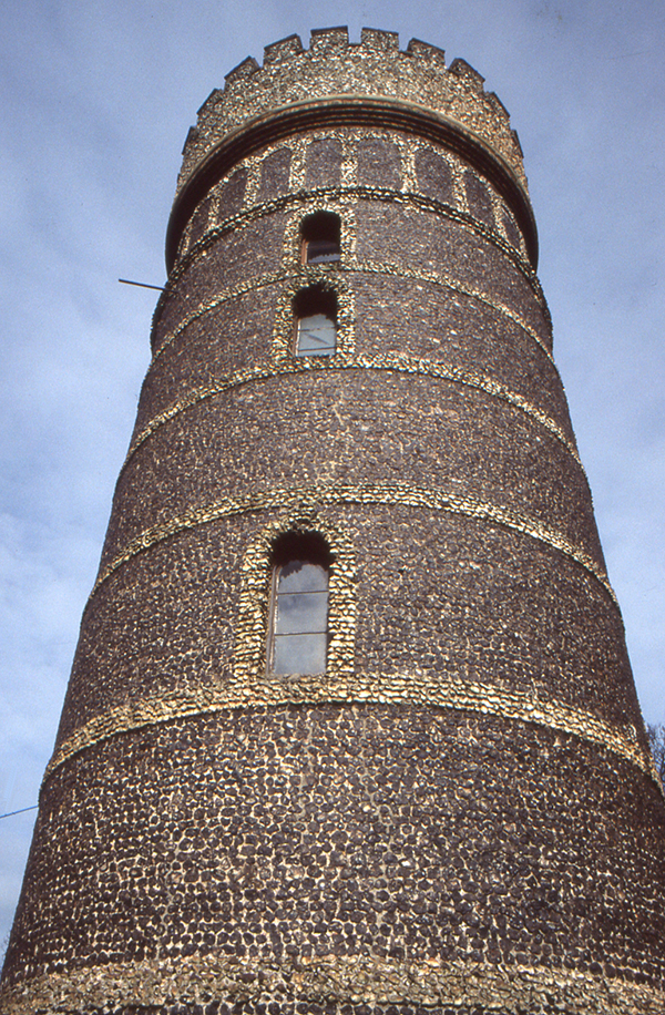
The image for Day 262 of the VM_365 project is of one of the landmarks of Thanet’s industrial archaeological heritage, Crampton Tower at Broadstairs. The tower stands three stories high (24.38m) and is faced with flint, the ubiquitous building material of the small towns and villages close to the sea in Thanet. The divisions between the stories and the windows and doors are picked out with rough flint dressings and string courses. The tower and reservoir are Grade II listed.

The tower was built  to improve the supply of fresh drinking water to Broadstairs and was designed and largely funded by the English civil engineer Thomas Crampton (1816 – 1888),  a railway engineer of great ability, who among many achievements was responsible for a locomotive design, which enjoyed particular success on the continent.

Crampton was born in Broadstairs, the son of a plumber and architect. His parents managed or owned therapeutic baths at Eldon Place, Broadstairs whose warm showers were notably enjoyed by Charles Dickens. Thomas Crampton had been involved in the construction of the Berlin Water works in 1855 and formed the Broadstairs Water Company in 1859.

In the Broadstairs Water Works designed by Thomas Crampton, water drawn from a deep well sunk into the chalk was stored in a large reservoir holding 380000 litres, which was covered by an impressive flint and mortar dome. A gas operated engine, which possibly survives in the tower floor, pumped the water from the reservoir to a tank at the top of the tower, where gravity created sufficient water pressure to supply houses in the nearby area.

Crampton’s water tower is one of the significant steps in the development of Broadstairs  from a cluster of fishermen’s cottages and boat building yards into a small town with the modern conveniences that were expected by visitors to the area and its growing population in the 19th century.

For more information about Thomas Crampton and Crampton Tower, visit Crampton Tower Museum in Broadstairs.

VM_365 Day 261 Two sides to Archaeology at Drapers Mills Margate

VM 261
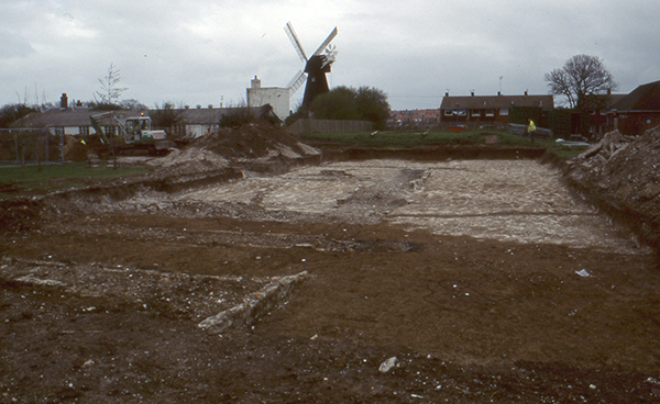
The image for Day 261 of the VM_365 project shows two aspects of the archaeology of Drapers Mills, Margate, both from very different periods but occupying the same landscape.

In the foreground of the image the excavation of a Late Iron Age or Early Roman enclosure is taking place on the playing field of a school. The ditched enclosure is located on the periphery of the site of a Romano-British villa, which was disturbed by the construction of the school in the 1930’s and investigated by excavations between 1959 and 1961 and again in 1981.  The villa probably replaced a small Iron Age settlement, which lay within the enclosure ditch. A filled in chalk quarry from the Roman period in the 2nd century AD, located near the houses to the right of the mill in the image, produced the cast bronze head of a boxer which appeared in the image for Day 17 of the VM_365 project. A wooden box storing a collection of the samian pottery from the villa excavations of 1959 to 1961 in the same area featured in VM_365 Day 86.

In the background at the centre of the image is Draper’s Mill, a smock mill constructed in 1845 by the Canterbury millwright John Holman. A smock mill has a sloping body, with a cap at the top that rotates so that the sails can be turned to face the wind. The windmill is the last survivor of three mid 19th century windmills that that once stood together on this rounded downland hilltop. Draper’s Mill was threatened with demolition in 1965, but was saved and restored in 1968.

Early maps show windmills occupying the hilltop near Drapers Mill as early as the 17th century, and it is likely that there were earlier post mills near the site in the medieval period, standing on similar trestle platforms and possibly within circular enclosures,  to those at St. Peters and Sarre that were shown on VM_365 Day 259 and Day 260. The hilltop site overlooking the bay at Margate has been occupied for many thousands of years and its history is written in the archaeological record, both above and below ground.

VM_365 Day 67 17th century Malthouse, King Street, Margate

VM 67

Today’s journal entry is inspired by Margate Brewery’s recent blog post about their future new premises at the High Street, Margate where they have established a 17th origin for their building which has been associated with beer, wine and spirits for most, if not, all of its lifetime.

While we are no experts in these kinds of structures, this made us think of other buildings in Margate connected with brewing and probably one of the least know standing buildings is a structure known as The Barn which is located to the rear of the Tudor House on King Street. This flint structure, shown on the right hand side of the picture, partly rebuilt in modern brick and heavily altered over the years, has been identified as a purpose built Malthouse constructed in the 17th century and used to malt barley to be used in the brewing of ale.

The Reverend John Lewis published an interesting passage in 1736 about malting and brewing in Margate:

‘…Malting is another Branch of the Trade of this Place, which was formerly so large, that there about 40 Malt-houses in this parish. But this trade also is now gone much to decay; tho’ certainly here might be the best Malt in England, the barley which grows here being so very good, and the Land naturally so kind for it. The Malt, it seems, here made, having formerly been very coarse for the Use of the Distillers, it has so much lost its Credit, that the present Maltsters find little Encouragement to make their Malt fine for a London Market, where they are almost sure to be out-sold by the Hertfordshire and North Country Malt-men, whose Malt bears a better name

About 40 Years ago, one ____Prince of this Place drove a great Trade here in brewing a particular Sort of Ale, which, from its being first brewed at a Place called North-down in this Parish, went by the Name of North-down Ale, and afterwards was called Mergate Ale. But whether it is owing to the Art of brewing this Liquor dying with the inventor of it, or the Humour of the Gentry and People altering to the liking [of] the Pale North Country Ale better, the present Brewers vend little or none of what they call by the Name of Mergate Ale, which is a great Disadvantage to their Trade ‘

(Lewis 1736, 134)

The breweries being established in Margate are not so much a new phenomenon, more a return to an old local tradition of brewing fine beer.

References

Austin, R.  2014. Tudor House, Margate. In Canterbury’s Archaeology 2012-2013. Canterbury Archaeological Trust, 21-22

Lewis, J. 1736. The History and Antiquities as well Ecclesiastical as Civil, of the Isle of Tenet, in Kent. Second Edition (Reprinted by Michaels Bookshop, Ramsgate)


VM_365 Day 55 Making Time for Ramsgate’s Historic Buildings

Ramsgate Harbour Clock House

The image for Day 55 of VM_365 celebrates Ramsgate’s rich architectural heritage.

In Britain many buildings are listed by English Heritage for their outstanding historical or architectural merit and Ramsgate has one of the highest densities of listed buildings in the country.

The Clock House at Ramsgate Harbour, currently housing the Ramsgate Maritime Museum, is one of the 5.5% of buildings that enjoy a II* listing, regarded as particularly important buildings of more than special interest.

The early work to construct Ramsgate Harbour was undertaken by John Smeaton between 1774 and his death in 1792. In 1794, after a trial period following Smeaton’s death, Benjamin Wyatt took over as engineer for the Ramsgate Harbour Trust.  Although Smeaton had completed the basic structure of the harbour, Wyatt was responsible for maintenance and the construction of  additional harbour buildings and he produced designs for several improvements and new structures.

On Wyatt’s death on 7th February 1807, he was succeeded as engineer for the Ramsgate Harbour Trust by the Scottish civil engineer John Rennie who had carried out many architectural projects for the Admiralty and had consulted with Wyatt on his plans for Ramsgate Harbour. The Clock House building was originally designed by Wyatt and George Louch, his deputy engineer who had been appointed in 1801, as a single storey store house and offices. The building was constructed by Rennie in 1817 from their design.

John Rennie’s second son, also called John, succeeded his father in his civil engineering business in 1820 and also as the engineer for Ramsgate Harbour. Rennie junior continued the maintenance and construction works in the harbour, which included the additions that were made to add the upper storeys and tower to the harbour building turning it into the Clock House that we see today.

The operation of a clock and a unique solar meridian established for Ramsgate, 5 minutes and 41 seconds ahead of Greenwich Mean Time, was described by a naval officer in 1837:

‘In the dome is an astronomical clock, and a meridian line, fixed, by means of a wire, which is used to ascertain its error, for the purpose of rating the chronometers of vessels entering the port…’

The original clock was built by John Moore and Sons of Clerkenwell under the supervision of physicist Henry Kater who had made advances in the design of astronomical clocks. A brass  transit line marking the Ramsgate meridian was set in the first floor of the Clock House building until it was stolen in 1975.

Accurate time pieces were essential to navigation in the early 19th century and their calibration to the fundamental Greenwich Mean Time datum was equally important. Many harbours had prominent clocks that could be observed and used to calibrate on-board navigational clocks by ships that entered the ports.

In 1846 the clock in the tower was replaced with a new clock mechanism made by London clock maker Edward John Dent.  With four, 5ft diameter gas lit dials, operated by rods to keep the mechanism away from the gas lights, the mechanism was housed in the dome along with the meridian apparatus. At Dent’s suggestion, from the 1st of November 1848, the new clock at Ramsgate showed Greenwich Mean Time, bringing an end to Ramsgate’s idiosyncratic time zone.

Reference:

Anon. 1837. A brief history of Dover and Ramsgate Harbours; with a description of the Coast, between Dungeness, and the Isle of Thanet, and remarks on the probable construction of a Harbour, between the South Foreland and Sandwich Haven. By a Naval Officer. London.

Matkin R.V. 1976. The Construction of Ramsgate Harbour. Transactions of the Newcomen Society, 48(1), pp. 53–72

Robinson J. M.  1973. Samuel Wyatt at Ramsgate. Architectural History Vol. 16, (1973), pp. 54-59+95-96

VM_365 Day 46: Serene Place, Broadstairs

46

This very attractive historic little corner situated just off Broadstairs High Street is Serene Place and the buildings within it date from the 17th to the early to mid 19th century.

The Serene House, the second building from the left is the earliest in the group and seems to have originally been constructed around 1603, probably as a timber framed building. It was refronted in the 18th century when it was faced with flint with red brick dressings. The building has a beamed interior and an inglenook fireplace.

Bradstow House, the building on the corner of Serene Place and the High Street, is early 18th century and was originally constructed as a single house but is now a house and the Old Bake House and cafe. The shop front that you can see was constructed in the 19th century.

Castle House, first from the left, and Lancaster House, third from the left are both Georgian. Castle House, built in the early 19th century is a three storey brick building with a basement. Lancaster House, a 2 storey townhouse faced in flint, was built in 1824 for Samuel Lancaster after whom it was named.

The tithe map of Saint Peter published in 1842 shows these houses facing onto an open area of land. After 1842 this was infilled with a terrace of houses facing Serene Place named Raglan Place. Only 3-5 Raglan Place survive of this early 19th century terrace.