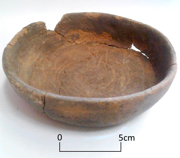
Today’s image shows a handmade, straight sided dish that was found in a Roman grave at Ramsgate. The dish, made from grog and quartz sand tempered fabric with a few shell inclusions, had been heavily used before it was placed in the grave at the feet of a young woman aged between 18-25 years along with two other vessels.
There are many questions we would like to ask when we find objects in these circumstances:
Did this vessel belong to the occupant of the grave or to a family member? What did she use the dish for? Did she use it for eating from or did she use it in cooking, perhaps to make pies* or other meals? Were the knife marks in the base made by her?
Despite all our efforts archaeology may not be able to answer these questions from the evidence that remains.
*Pies are mentioned in a collection of cookery recipes, Apicius, believed to date from the late 4th to 5th centuries.
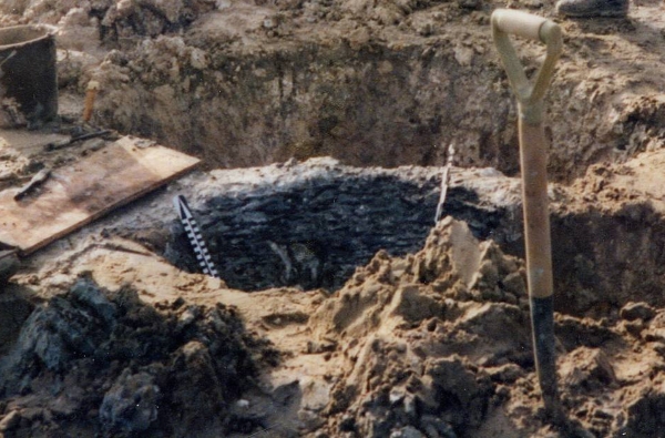
For Day 65 of VM_365 the image shows one of the most important sites in Thanet for understanding how the changing landscape can throw up problems for archaeologists when they are interpreting features and finds in the landscape.
In the centre of the picture is a pit under excavation on the foreshore at St. Mildred’s Bay on the north coast of Thanet. Against the back edge of the pit can be seen the thin horizontal and vertical timber rods that form a woven lining to the pit, similar to a woven basket closely fitting the size of the pit.
In the dry chalk landscape of Thanet, pits and other features of this age are generally filled with sequences of chalky soils or clay and silt deposits, with no hint that any organic deposits ever existed. In other parts of the country where archaeological features have been found in waterlogged conditions, many examples of the use of organic materials and even complicated carpentry from sites of the same date have been recovered. Because the conditions in Thanet are not good for preserving organic material, all trace of this part of the record has been erased.
If recording is carried out with care and attention, archaeologists can deduce that such material may once have been present, lining pits and forming structures that are now undetectable apart from the holes that were dug for them or the material that eventually replaced the organic deposits. The positive aspect of the discovery of sites on the foreshore in waterlogged conditions has demonstrated that the absence of this material elsewhere is due to the conditions of preservation not the absence of this material in the period.
The negative aspect is the interpretation of the location of these sites at the time they were created. Thanet’s land mass has been diminishing year after year as rising sea levels have covered land and the sea has eaten away the chalk to form the cliff line and the flat platforms of the foreshore. Sites like the one in today’s image were not on the coast when they were created, they may even have been some distance away from the coast and we must be careful not to give an undue significance to the present coastal location of the sites when they had no bearing on the settlement at the time.
It was a matter of good luck that some archaeological features were preserved in the platform cut by the waves around the coast, leaving remnants behind in waterlogged conditions to give us an idea of what life was like on dry land four or five thousand years ago. It is clear from evidence like this that the study of the dynamic landscape and attempts to understand and represent the changes on maps are an important part of the archaeologists tools for interpreting past societies.
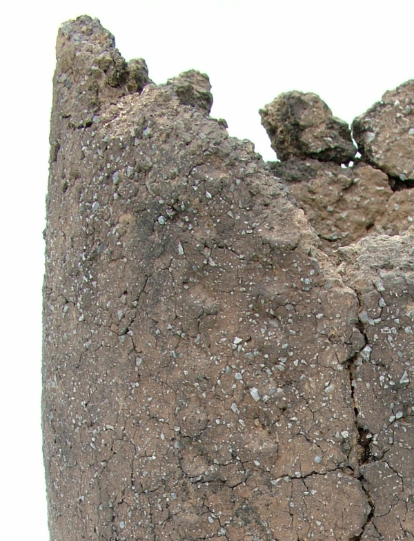
If you look carfeully at this close up of the fabric of a Middle Bronze Age pottery urn from Ramsgate you can see two aspects of human interaction with the landscape which are preserved at a relatively small scale in an everyday object.
The material was worked by the potters into the common forms that were part of their culture but the feel of the material was a direct reflection of the immediate landscape of the potter. Each region may have shared common vessel types, which could be transmitted through examples and ideas, but the materials the vessels were made from were gathered locally and were usually distinctive in their fabric which were rooted in the local landscape.
Bronze-Age round barrow on hilltop overlooking Pegwell Bay
How does an archaeological site reflect its landscape? This image for VM_365 Day 63 shows how important location within a landscape is for the choices that are made on where to live, work and celebrate.
Bronze Age round barrows like this one at Ramsgate were formed by digging a circular ditch into the hard chalk of the hillside to create a mound in the centre from the spoil from the ditch. Very frequently, but not in every case, the central mound covered the burial of an individual which was itself laid in a chamber created by cutting a rectangular pit into the chalk.
But what motivated the choice for the location of each round barrow? This image contains one answer to this question in the vista over Pegwell Bay which can be seen beyond the section of the ditch revealed in the trench. From this position the land from Deal, the eastern mouth of the Stour and the mouth of the valley of the Wantsum, sweeping through to the northern side of Pegwell Bay where the open sea was visible beyond the land. On a clear day the cliffs on the coast of France can also be seen on the horizon from this location.
In general, similar Bronze Age funerary monuments in Thanet have been found in commanding locations on the convex slopes of hillsides and valleys which the undulating chalk downs of Thanet possess in abundance. In each location the commanding view demonstrates that the position was carefully chosen and surveyed to assess the suitability of the site.
Before we interpret the motives behind such choices of position, we need to consider that the landscape has changed from that of the Bronze Age through coastal erosion and sea level rises. The Bronze Age barrow burial rite also lasted some centuries and within the monuments recorded we need to consider what influence the choices of earlier people had as time passed.
Many of the best sites may have been taken at an early stage, or perhaps the best locations were identified and rationed in some way that was determined by the culture and contemporary ideas of rights and status. To date there has been little evidence that barrows were partially overlapped to usurp the space taken by an earlier monument, although we do have evidence that the ditch of an earlier barrow was re-excavated and trimmed, possibly to accommodate a new burial. Perhaps it was acceptable to re-use a barrow, respecting and associating a new person with the personality and status of the earlier burial, but it was not acceptable to damage an earlier barrow and erase the memory of the significance of the earlier burial.
The landscape seems to have had a deep resonance in the culture of Bronze Age Thanet, although we can only work out the ways these were turned into cultural forms by reasoning from our data on the location of features within the landscape and considering the logic of the placement of the sites within the space and land forms that were available. In short, archaeology loses an important dimension if context within its landscape does not form part of the archaeological investigation that is applied to it.
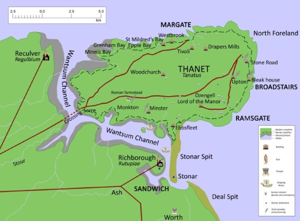
The distinctive landforms that shape Thanet’s history
The map shown here for VM_365 Day 62 is of the underlying shape of the landcape of the Isle of Thanet, a factor which has shaped its history and culture over many centuries.
The shaded relief of the map was created using height data taken by the NASA space shuttle as it orbited the earth. Unlike yesterdays image which showed the locations of all the discoveries of archaeological remains from a particular historical era, the Roman period, this map shows the enduring structures of the Isle of Thanet’s landscape.
Modern development has sometimes disguised the natural shapes of the chalky slopes and valleys that divide up the space that has been occupied in Thanet for over six thousand years, but with careful observation you can still recognise its major features, although less so as new housing estates and roads change the natural rhythms of the landscape each year.
If you are out and about on the Isle, look around and see how the land rises and falls and in places gives amazing views over the slopes and to the sea. Observe how the various towns and areas occupy particular slopes or are separated by valleys. Follow the routes of the Islands older roads over the ridges and up the slopes of the network of valleys that underpin the landscape.
The ancient inhabitants of Thanet were acutely aware of the shape of their landscape and chose the sites of their settlements, ceremonial sites and burial grounds with their location on specific landscape features in mind. Lines of sight between locations were important, as were vistas where large distances could be see all around. Access to resources or to the sea and the flat grounds at the top of the hill shaped the way the Island’s people moved around. Sometimes the relative effort of getting from one place to another dictated the way settlements grew up around the area.
To understand the distribution of sites in one particular period we need to understand that the one relatively constant factor in the development of society over time was the influence of the physical shape of the land. Understanding the shape of the land can explain the choices made when settling the landscape as well as the changes that happened over time.
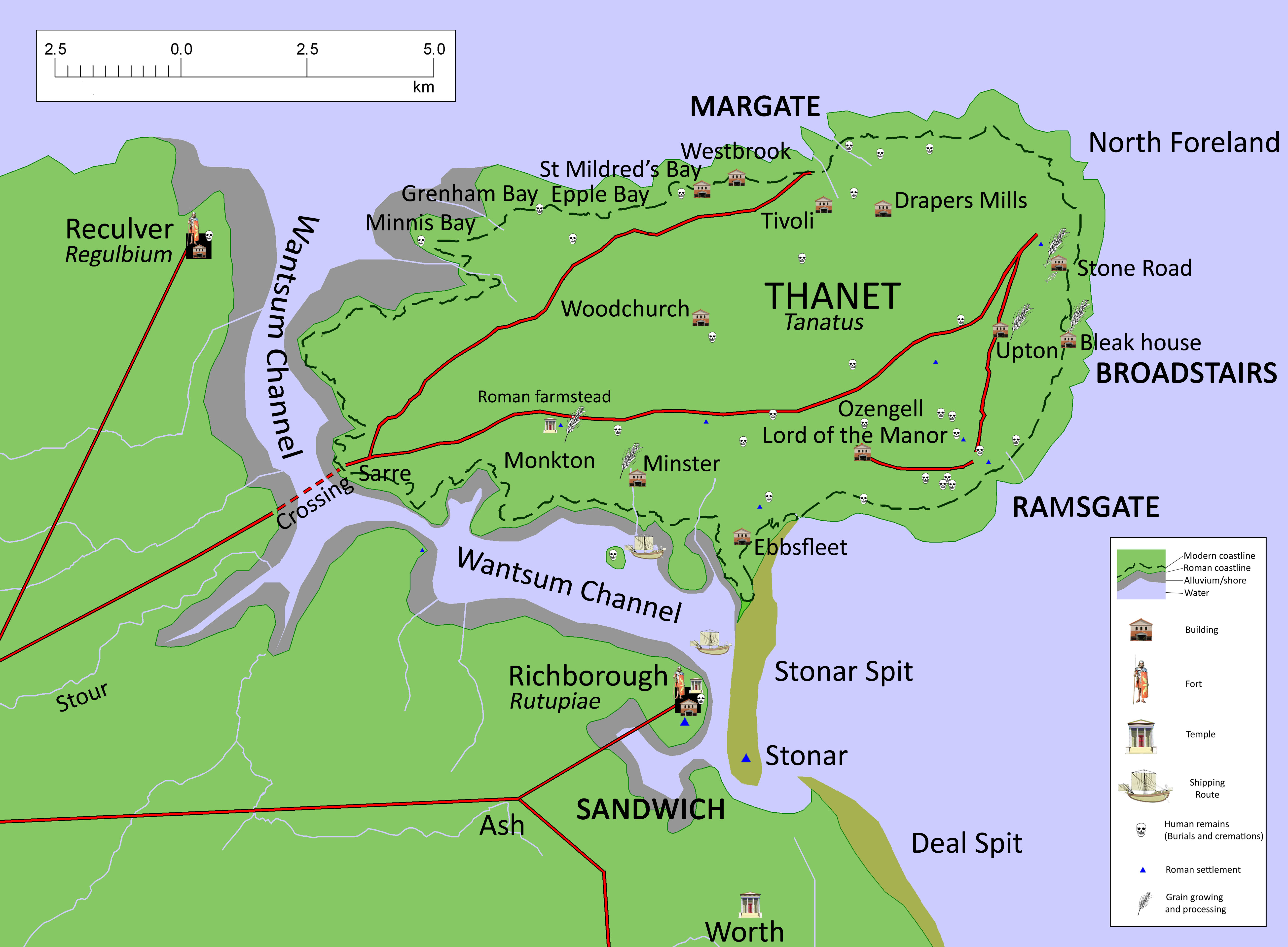
Today’s image for Day 61 of the VM_365 project shows a map of Roman Thanet that was produced to accompany an exhibition called Roman Thanet Revealed, which was curated by volunteers and was on display at the Powell-Cotton Museum in Birchington from April to October 2011.
The map showed an up to date list of major Roman sites that have been identified on Thanet, including the new buildings that had recently been discovered at Upton, Stone Road and Fort House, Broadstairs (shown as Bleak House on the map), as well as the villa at Minster. The map was created to illustrate the locations of the various items on show and to place the discoveries into the context of the networks of roads, towns and forts that would have formed the central places in the Romano-British community.
A map like this serves a number of purposes. It records the location of the discoveries that have been made by archaeologists in specific locations, but it also allows connections to made between the sites and the landscape that they stand in which helps to create a narrative of similarities and differences within the period and to suggest interactions between types of sites and locations .
Recent research has shown in detail the changes that must have taken place in the coastline of Thanet since the Roman period and this map suggests where the Roman coast line might have been. Archaeological evidence in the form of recently rediscovered records and finds from a Roman cremation burial and structure from Boxlees Hill within the channel, show clearly that the Wantsum Channel which separated the Isle of Thanet from the mainland of Kent was not as open and navigable as was once thought. It is shown in the map with a wide margin of tidal silts with only the central channel open to the passage of ships.
Several recently published histories of Roman Britain have underestimated the density of settlement in Thanet in the Late Iron Age and Roman period, perhaps because some sites have remained unpublished and also because there is no permanent place to show and promote Thanet’s archaeological remains. As the Roman Thanet Revealed exhibition ended, our Roman history went once more into relative obscurity.
Further reading:
The ancient landscape of Thanet from the Ice Age to the Anglo-Saxon period is explored through a series of revealing historic maps of Thanet and new reconstructions based on geological and archaeological detective work in the book St. Augustine’s First Footfall which is published by the Trust for Thanet Archaeology.
The story of Thanet’s Archaeology from Prehistory to the Norman Conquest was explored by the Ges Moody of the Trust, using a series of maps and archaeological evidence. The Isle of Thanet from Prehistory to the Norman Conquest is available from all high street bookshops and online book-sellers.
Thanet’s industrial heritage has been a relatively neglected subject, although it is increasingly obvious that more attention should be paid to the sites and artefacts associated with the industrialised agriculture of the 19th century.
A common site in many of the villages and towns of the area would have been a blacksmith, who would have been involved in manufacturing and repairing farm equipment as well as shoeing the many horses that provided transport and power.
We came across this round iron plate, nearly 1.5m in diameter on the site of an old blacksmith’s forge in St.Peters, Broadstairs. As it was not in our usual experience of archaeological artefacts we had to do some research to find out what it was.
The flat iron disc with a central hole turned out to be a hooping plate, used to fit iron hoops to the outside of wooden wagon wheels. The hub of the wheel would sit in the central hole and the hoop, which was expanded by heating it in the furnace, would be placed over the wooden rim and hammered into position against the hooping plate, which kept the wheel flat and firm. When the hoop was cooled it would tighten up around the wheel creating an iron tyre that would keep any heavily laden farm wagon going on the country lanes for another season.
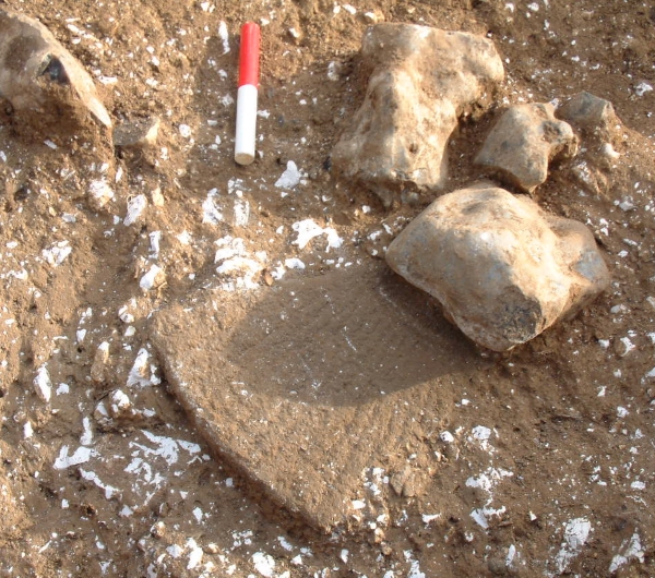
3rd century Roman millstone fragment from Upton, Broadstairs
Todays VM_365 image comes from the excavation of a Roman period cellar at Upton, near Broadstairs, one of the three areas where the Trust has established the presence of Roman building remains in Broadstairs in the last decade. Like the sites at Stone Road and Fort Hill, nothing remained of the structures that would have been above ground level at the Upton site.
To undertand what the cellared buildings we have located might have been we need to look closely at the finds that are associated with them, to gain some context and to be able interpret the uses they were put to. In both the building at Upton and at Stone Road large pieces of finely dressed millstones were found. The one in the image above was around 50mm thick, the upper surface had been dressed with an even pecking all over, the lower face had a series of teeth cut into the surface radiating from the 100mm diameter central hole. The whole millstone had a diameter of approximately 0.83m. Stones like this would have been large and heavy and while it is possible they were worked by hand, it would have taken considerable effort and perhaps animal power might have been used to drive them.
In the future perhaps research and observation of communities that still use similar millstone as well as experimental archaeological methods could give a greater insight into the quantity and quality of the flour that could be produced and perhaps the food that could be made with it.
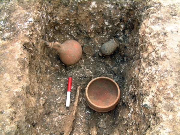
Following on from Day 56’s image of one of the Roman graves excavated at Grange Road, Ramsgate, today’s image shows one of the grave assemblages from the same site.
This assemblage was found in the grave of an adult female who was buried wearing a copper alloy twisted wire bracelet and was wearing foot wear with hobnails. The assemblage you can see in this picture was found at the foot end of the grave and included a second copper alloy bracelet, a pottery dish, a flagon stoppered with a flint and a beaker. If you look carefully, you can also see a length of copper alloy wire, near the dish that may have been twisted around a fabric bag.
It was items like this that Hicks was recovering in the new developments in this area of the town in the 19th century.
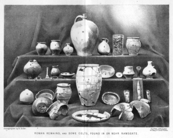
Photograph of artefacts found in or near the Ramsgate area published by Robert Hicks MRCS in 1878
Following on from the image of a Roman burial at Ramsgate from VM_365 Day 56, today’s picture shows a collection of archaeological artefacts from private collections that were discovered in Ramsgate before the photograph was published in an article for Archaeologia Cantiana, the journal of the Kent Archaeological Society, in 1878.
Ramsgate was lucky to have one of Thanet’s most diligent and learned pioneering archaeologists in Robert Hicks, a surgeon who joined Ramsgate’s Seaman’s Infirmary & General Hospital in the middle of the 19th century and maintained a keen interest in the local archaeological discoveries that were being made as the town expanded. Hicks deserves to better known in the story of Ramsgate’s cultural heritage and it would serve the town well if more biographical details could be added to his own story by some local researcher.
Robert Hicks oversaw the collection and photographing of the artefacts and and wrote the article that it illustrated. To accompany the picture in the published article, reproduced in the image above, Hicks listed the location where each of these finds was made, giving a brief description and dates for each of them as current archaeological knowledge stood.
While his focus in the article was predominantly in the abundant finds of the Roman period, several of the artefacts shown in the picture published in the 1878 article are certainly from earlier periods in prehistory, including Mesolithic, Neolithic and Bronze Age axes and what seems to be a finely made Early Bronze Age flint dagger. Two Iron Age fibula brooches are present, along with several late Iron Age ‘Belgic’ pottery vessels.
Sadly none of these artefacts can be located today and Ramsgate’s heritage is poorer for the loss of a collection of artefacts that would grace any local museum and would contribute to telling a longer and more complex story of the area than is generally known to the town’s residents. Now only Hicks’s published photograph exists to help us understand what we have lost.
Reference
Hicks R. 1878. Roman Remains from Ramsgate. Archaeologia Cantiana Vol.12, p.14 – 18.