Monthly Archives: May 2015

VM_365 Day 314 Mid Saxon pottery fabrics from Westgate

VM 314

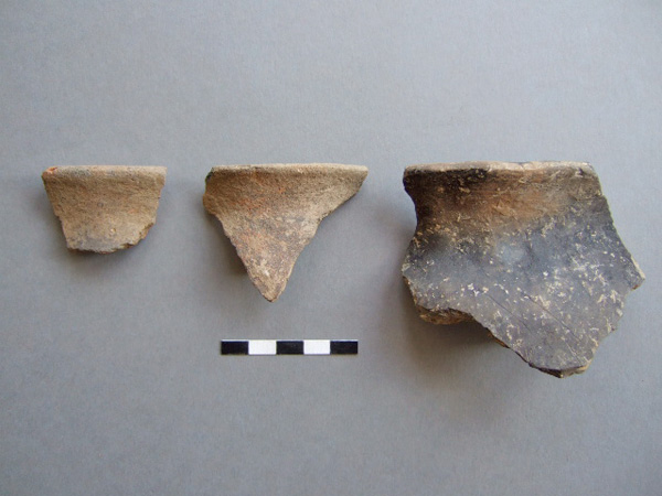
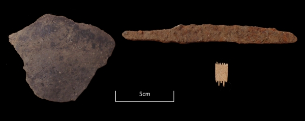
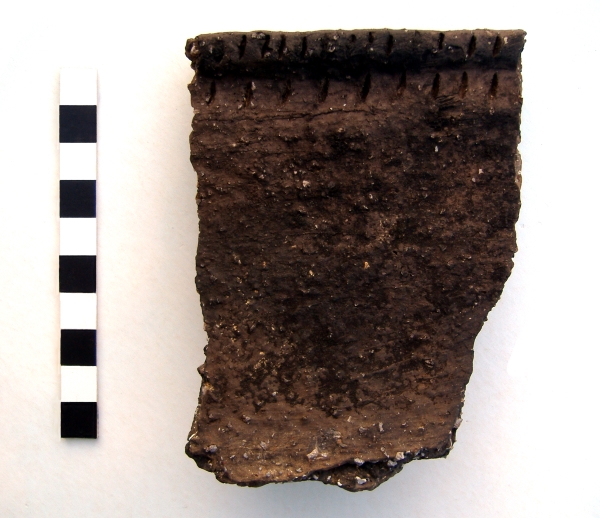
The image for Day 314 of the VM_365 project is  of examples of pottery fabrics dating from the Mid Saxon period, spanning the mid 8th to the mid 9th century.

Pottery in Kent and elsewhere in this period was mostly handmade, with small bag-shaped vessels with everted rims most common. Some had their rims more neatly and evenly finished by turning the pot on a tournette, a stick or hand-turned wheel.

In East Kent two main fabric types were employed; sandy ware and shelly ware, the latter sometimes with some additional sand added.
Most of the the Mid Saxon sandy ware products were made at sites near Canterbury, beginning a nearly 900-year long period of continuous pottery manufacture in these workshops.

The two left hand rim fragments in the image are from cooking jars in Canterbury sandy ware fabrics. A small everted rim cup in a similar dark grey sandy ware fabric featured in the post for Day146 of the VM_365 project.

The larger rim at the right-hand end of the picture is from a larger vessel in shelly ware. The small plates of deliberately crushed shell are just visible on the surface of the sherd.

All of the sherds shown can be dated to a period between c.750-850 AD  which is currently rarely represented in Thanet’s archaeological record. The relative scarcity of pottery of this period is partly due to the fortunes of archaeological recovery. Few sites have been found in Thanet’s rural and coastal landscape and all the sherds shown as well as the cup in the earlier post were from a single site near Westgate. Much of the occupation in this period will have been masked by later medieval settlement and dwellings will have been mainly wooden structures which can be hard to detect. The rather low-fired pottery is vulnerable to damage from modern agricultural or building activity.

The information and images for this post were kindly provided by Nigel Macpherson Grant.

VM_365 Day 313 Colour coated dish from Minnis Bay, Birchington

VM 313
After P. H. G. Powell-Cotton and G. F. Pinfold, 1939, Plate IV.

Today’s image for Day 313 of the VM_365 shows half of a Roman pottery bowl found in one of the pits excavated and recorded by James Beck and Antoinette Powell-Cotton at Minnis Bay, Birchington in 1938.

The bowl, described as a half of a red ware colour coated dish, was found in the same pit as the double handled wine jug featured in yesterday’s post for Day 312 of the VM_365 project. Half of a 4th century black pottery vessel, fragments of millstones and part of an upper quern stone were also found in the pit.

VM_365 Day 312 Roman pottery from pits on foreshore at Minnis Bay

VM 312
After P. H. G. Powell-Cotton and G. F. Pinfold, 1939, Plate III.

Today’s image for Day 312 of the VM_365 project shows three Roman pottery vessels found and excavated by James Beck and Antoinette Powell-Cotton in pits on the foreshore of Minnis Bay, Birchington in 1938.

The vessel on the left hand side of the image was found in a square shaped pit and is described as a ‘grey Belgic vase’ by Major Powell-Cotton and G. F. Pinfold in their report and catalogue of the site in 1939. This late Iron Age/Early Roman vessel was found along with the base of a 1st century rough cast pottery beaker and a fragment of Quern stone.

The vessel shown in the centre of the picture is described  as a two handled wine jar of New Forest type.  A wide range of wheel thrown fine wares were produced in the New Forest  in the 3rd and 4th century,  sometimes decorated as is the case with this vessel, and are generally found distributed across southern Britain. The vessel was found complete, in a pit along with some other pottery and a fragment of the upper part of a quernstone.

The vessel on the right was found in a pit beneath the millstone that featured in yesterday’s, Day 311 post for VM_365. The vessel was described as a fine red ware pot with the remains of decoration with white slip.

Some of the pits may be the remains of the bottoms of well as three contained springs. The pottery found in the pits dates from the early 1st century to the 3rd or 4th century indicating that this area had been a focus of activity by the Romans for at least 300 years.

VM_ 365 Day 311 Roman millstone from a pit at Minnis Bay.

VM 311
After P.H.G Powell-Cotton and G. F. Pinfold, 1939.

Today’s image for Day 311 of the VM_365 project shows a large Roman Millstone found on the foreshore at Minnis Bay in 1938 by a 14 year old schoolboy named James Beck. The picture of the millstone was taken at the Powell-Cotton Museum where the millstone now resides.

James Beck identified and excavated a group of eight pits of Roman date assisted by Antoinette Powell-Cotton. The millstone, measuring nearly a metre in diameter and almost 12 centimetres thick, was found covering one of the pits, an irregular shaped cut which measured about 73 centimetres deep. A fragment of millstone of a similar date found at Broadstairs previously featured on Day 59 of the VM_365 project. Below the millstone, the pit also contained a fine red ware vessel, two fragments of samian pottery, horses teeth and fragments of wood.

James Beck also identified a Bronze Age site in the same area as the group of Roman pits and excavated and recorded a Bronze Age hoard that was previously featured on Day 202 of the VM_365 project.


VM_365 Day 310 Early Medieval foundations at St Mildred’s Priory, Minster

VM 310

Today’s image for Day 310 of the VM_365 project continues  our theme of keyhole excavations and the important archaeological information that can be gleaned from them. The image shows two views of the remains of a rammed chalk foundation that was recorded during the work in 2010 to re-lay drains at St Mildred’s Priory, Minster. The Priory is located on the the eastern edge of the village of Minster, on low lying lands overlooking the marshland in the former Wantsum Channel.

The standing buildings at St Mildred’s Priory, which has also been known as Minster Abbey and St Mildred’s Abbey, date from the  11th and 12th centuries and were constructed as a monastic grange by the Benedictine Monks of St Augustine’s Abbey Canterbury after the land was granted to them by King Canute.

The site of the monastic grange had previously been occupied by a nunnery, established at Minster by Domneva, a niece of  King Egbert of Kent in the 7th century. Domneva’s daughter later became known as St Mildred, after whom the Abbey was later named. The early nunnery was reported to have been destroyed during the Viking incursions in the 9th century after which the land became a farm, or grange, for St. Augustine’s Abbey.

The buildings of the monastic grange were renewed and altered in the early 15th century and the standing remains include herringbone walling, Norman doorways and windows and a medieval brewhouse. Following the Dissolution of the Monasteries in the mid 16th century, the grange passed into private hands and the former monastic grange has been used as a Benedictine nunnery since 1937.

In 2010 work was carried out to re-lay the 19th or early 20th century drainage pipes located on the western side of the northwestern range of buildings known as the Saxon Wing. This involved digging out the backfill of the old pipe trenches, exposing the existing pipes and then relaying them with modern pipes.

In one of the trenches a demolished wall or wall foundation of rammed chalk was exposed, forming a corner of a structure with a different orientation to the standing buildings of the former monastic grange.  In the picture on the left the foundations are visible below the original pipes and in the image on the right the foundations can be seen after the original pipes have been removed.  The interior of the wall appeared to have originally been faced with pieces of sandstone. Crushed fragments of sandstone found in the demolition deposit above the chalk foundation suggest that the upper part of structure may have been formed of sandstone blocks.

Two fresh sherds of North Kent shell filled sandy ware pottery from a sagging base cooking pot, dating to 1150-1225 AD, were found in a deposit built up against the outer face of the wall suggesting the structure dated from this period or earlier. The building materials associated with this wall foundation are similar to those of the west wing, part of which was constructed before 1085. In the 12th century the grange was enlarged and the west block was converted into kitchens and living quarters.

It is not clear whether the structure exposed in the pipe trenches relates to a new structure, built when the west block was converted, or whether it was a structure demolished to make way for the 12th century rebuilding. However this small keyhole excavation has indicated the location of the footprint of an early structure associated with this important medieval building and may provide a guide to future investigations when a more extensive investigation of the structure  may be possible.

VM_365 Day 309 Artefacts from Anglo Saxon SFB at Woodchurch.

VM 309

Today’s image for Day 309 of the VM_365 project shows a selection of three artefacts which were found in the small segment excavated through the Anglo Saxon Sunken Featured Building from Woodchurch, Thanet that featured in yesterday’s VM_365 post for Day 308.

On the left hand side of the image is a sherd of Organic-tempered ware pottery of early to Mid Saxon date (c. 550/600 – 700 AD).

On the right hand side at the top of the image is an Iron Knife with a curved ‘hog-back’ blade, with a curved cutting edge that may be the result of repeated sharpening on a round section hone.

The small fragment of comb at the bottom of the image has been carved from bone and is from a one-piece double-sided comb. The spacing of the teeth is different on each side, suggesting that it had both a fine and coarse combing side.

VM_365 Day 308 Anglo Saxon SFB at Woodchurch, Thanet

VM 308

Today’s image for Day 308 of the VM_365 project shows a common type of archaeological feature of  Anglo Saxon date, known as a Sunken Featured Building, which was uncovered during an evaluation carried out in advance of the construction of a house at Woodchurch, Birchington in 2002. The picture is taken looking across the valley from Woodchurch toward the tree lined boundary of Quex Park. This is post is another example of a small keyhole investigation which has revealed important information without extensive excavation.

The depth of overburden above the chalk was less than 10 centimetres deep and so the entire footprint of the building was stripped to expose the chalk and reveal archaeological features. The Sunken Featured Building (usually shortened by archaeologists to the initials SFB) can just be made out in the centre foreground of the picture as a rectangular patch of earth slightly darker in colour than the periglacial brickearth stripe to the north and on which the photographic scales are placed.

Because it was possible to move the foundations of the house to avoid the SFB, only a small segment was excavated through it.  Artefacts recovered from the small area excavated included an Iron knife, a sherd of pottery and a small fragment from a double sided bone comb, which date the SFB from the mid to late 6th to 7th century.

Evidence of Anglo Saxon settlement is relativley rare in Thanet, compared to the known locations of cemeteries of this date. Other Sunken Featured Buildings have featured in previous VM_365 project posts, one from Margate on Day 83 and one from Sarre on Day 229.

The SFB at Woodchurch was abe to be preserved in situ and now survives below the lounge of the property.


VM_365 Day 307 Middle Bronze Age Urn from keyhole site at Westgate

VM 307
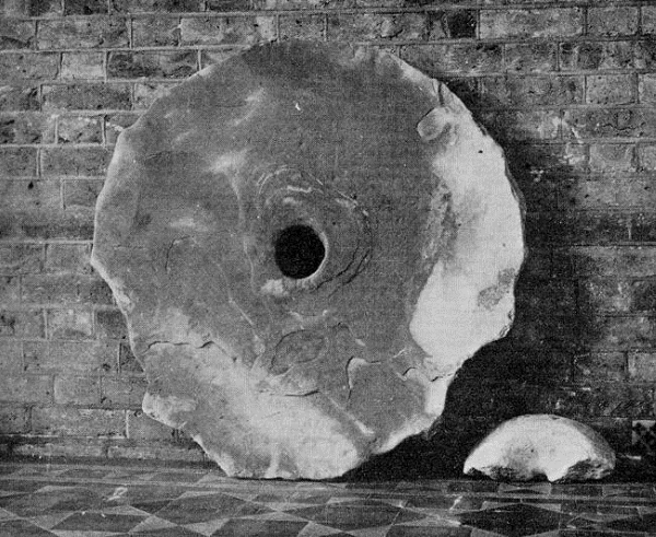
Today’s image, for Day 307 of the VM_365 project, shows a large sherd from a Middle Bronze Age, Deverel Rimbury style, pottery vessel that was excavated from the enclosure ditch that featured in the post for Day 306.

The sherd is one of eleven fresh conjoining sherds, including five small fragments, made of a characteristic heavily flint gritted fabric. The sherds come from the rim of a large Barrel Urn, measuring approximately 28cm in diameter at the rim and widening below the shoulder. The rim is decorated externally with two parallel rows of fingernail impressions.

The survival of such a recognisable and substantial collection of dateable pottery in a tiny remnant of an ancient settlement, demonstrates the value of observing the deposits that are revealed when construction sites clear a keyhole view into the ancient landscape.

VM_365 Day 306 Middle Bronze Age Enclosure at Westgate

VM 306

Today’s image for Day 306 of the VM_365 project shows another image from our series looking at archaeological sites revealed through the keyhole of small discoveries at sites in built up areas under Thanet’s towns, where construction work has opened a window into an ancient landscape that has been lost for many years.

The discovery was made in an area where a substantial amount of urban development has taken place, which has masked and sometimes destroyed the deposits and features that could provide evidence of the past occupation in the area.

The image shows a short stretch of an enclosure ditch dated to the Middle Bronze Age, which was exposed in groundworks for the construction of a house. The site had already been occupied by an extension that was used as a temporary police cell for a former police house and a garage.  The foundations for the  police cell can clearly been seen in the image above, located on the right hand side of the ditch before turning to cut it.

The ditch contained twelve sherds of pottery from three seperate Deverel Rimbury style Middle Bronze Age vessels. The discovery of a small surviving stretch of a Middle Bronze Age enclosure is a significant contribution to the prehistoric archaeology of the Isle of Thanet. The enclosure ditch may have formed part of a wider settlement and such features are always an important part of any attempt to map the historic occupation of the landscape.