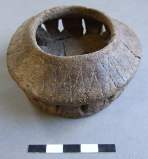
This unusual little vessel is a perforated Incense or Accessory cup of Early Bronze Age date. The vessel was found in the late 1970’s in a pit at the centre of a ring ditch which had been partially destroyed by the construction of the Haine Road at Lord of the Manor, Ramsgate. The ring ditch is one of a group of at least seven Neolithic and Bronze Age Monuments located on a chalk hilltop overlooking Pegwell Bay; one of the major ceremonial sites of prehistoric Thanet.
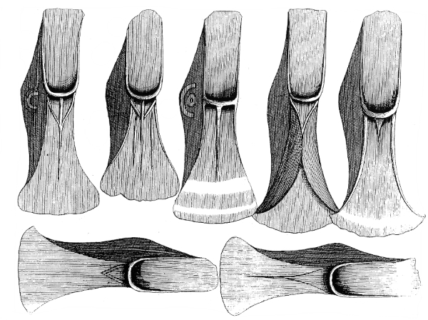
Today’s image shows an illustration of some of the objects in the first Bronze Age Hoard whose discovery was recorded on Thanet. The hoard, consisting of twenty seven palstave axes dating from the Middle Bronze Age, was found in 1724 at Mutrix Farm ( a place name also recorded as Mutterer or Motherwicks) on the cliff top near St Mildred’s Bay, Birchington. A record of this discovery, with the illustration shown above, was published in 1736 by the Reverend John Lewis in his book on the History and Antiquities of the Isle of Thanet:
‘Betwixt this place and the Sea were found AD 1724 by William Castle, who occupied a small Farm here, as he wwas digging a Sea-gate, or a Way thro’ the Cliff into the Sea, to fetch up Oore or Waure for his Land, XXVII such instruments as I have described in the adjoining Plate lying all together about two Feet underground, so that it is a little strange, that they were not before this discovered by the plough. They were of mixt Brass, or what they call bell or Pot-metal, of several Sizes, and somewhat different shapes, but on both Sides alike, as they are here represented. The largest of them were 7 Inches one quarter long, and 2 Inches three quarters broad at the bottom the lesser ones were 5 Inches in Length and 2 Inches and one half in Breadth at the Bottom. Two of them had Ringles on one Side about the middle, which was the thickest or deepest part.’
It has been suggested that the illustration reproduced by Lewis was copied from an original drawing made by the famous Antiquarian William Stukeley while he was travelling through Kent (Ashbee 2001).
References
Ashbee, P. 2001. William Stukeley’s Kentish Studies of Roman and other Remains. Archaeologia Cantiana 121, 61-102.
Lewis, J. 1736. The History and Antiquities of the Isle of Tenet. London. 2nd Edition
Perkins, D. R. J. 2000. A Gateway Island. Thesis submitted for the Degree of Ph.D to the Institute of Archaeology, University College London.
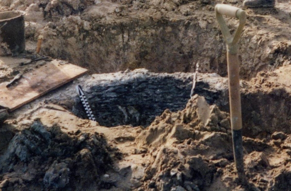
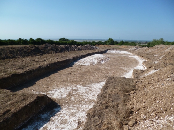
For Day 65 of VM_365 the image shows one of the most important sites in Thanet for understanding how the changing landscape can throw up problems for archaeologists when they are interpreting features and finds in the landscape.
In the centre of the picture is a pit under excavation on the foreshore at St. Mildred’s Bay on the north coast of Thanet. Against the back edge of the pit can be seen the thin horizontal and vertical timber rods that form a woven lining to the pit, similar to a woven basket closely fitting the size of the pit.
In the dry chalk landscape of Thanet, pits and other features of this age are generally filled with sequences of chalky soils or clay and silt deposits, with no hint that any organic deposits ever existed. In other parts of the country where archaeological features have been found in waterlogged conditions, many examples of the use of organic materials and even complicated carpentry from sites of the same date have been recovered. Because the conditions in Thanet are not good for preserving organic material, all trace of this part of the record has been erased.
If recording is carried out with care and attention, archaeologists can deduce that such material may once have been present, lining pits and forming structures that are now undetectable apart from the holes that were dug for them or the material that eventually replaced the organic deposits. The positive aspect of the discovery of sites on the foreshore in waterlogged conditions has demonstrated that the absence of this material elsewhere is due to the conditions of preservation not the absence of this material in the period.
The negative aspect is the interpretation of the location of these sites at the time they were created. Thanet’s land mass has been diminishing year after year as rising sea levels have covered land and the sea has eaten away the chalk to form the cliff line and the flat platforms of the foreshore. Sites like the one in today’s image were not on the coast when they were created, they may even have been some distance away from the coast and we must be careful not to give an undue significance to the present coastal location of the sites when they had no bearing on the settlement at the time.
It was a matter of good luck that some archaeological features were preserved in the platform cut by the waves around the coast, leaving remnants behind in waterlogged conditions to give us an idea of what life was like on dry land four or five thousand years ago. It is clear from evidence like this that the study of the dynamic landscape and attempts to understand and represent the changes on maps are an important part of the archaeologists tools for interpreting past societies.
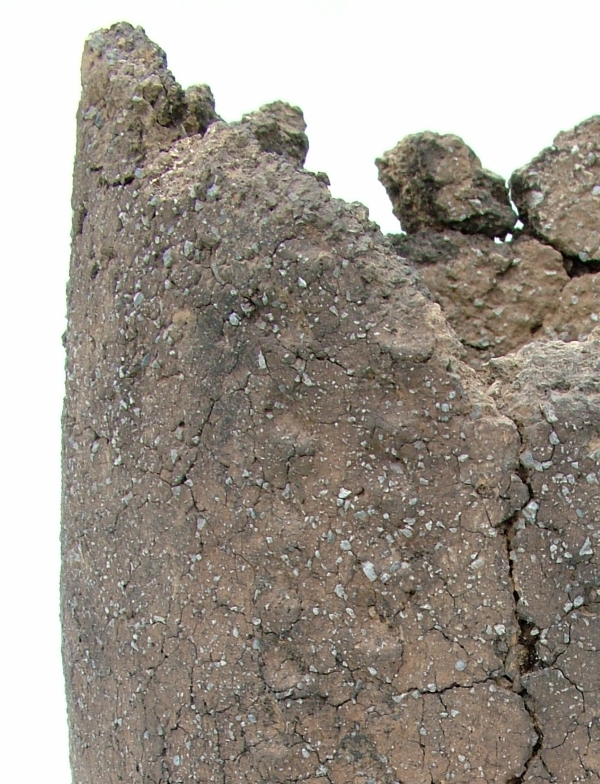
If you look carfeully at this close up of the fabric of a Middle Bronze Age pottery urn from Ramsgate you can see two aspects of human interaction with the landscape which are preserved at a relatively small scale in an everyday object.
The material was worked by the potters into the common forms that were part of their culture but the feel of the material was a direct reflection of the immediate landscape of the potter. Each region may have shared common vessel types, which could be transmitted through examples and ideas, but the materials the vessels were made from were gathered locally and were usually distinctive in their fabric which were rooted in the local landscape.
Bronze-Age round barrow on hilltop overlooking Pegwell Bay
How does an archaeological site reflect its landscape? This image for VM_365 Day 63 shows how important location within a landscape is for the choices that are made on where to live, work and celebrate.
Bronze Age round barrows like this one at Ramsgate were formed by digging a circular ditch into the hard chalk of the hillside to create a mound in the centre from the spoil from the ditch. Very frequently, but not in every case, the central mound covered the burial of an individual which was itself laid in a chamber created by cutting a rectangular pit into the chalk.
But what motivated the choice for the location of each round barrow? This image contains one answer to this question in the vista over Pegwell Bay which can be seen beyond the section of the ditch revealed in the trench. From this position the land from Deal, the eastern mouth of the Stour and the mouth of the valley of the Wantsum, sweeping through to the northern side of Pegwell Bay where the open sea was visible beyond the land. On a clear day the cliffs on the coast of France can also be seen on the horizon from this location.
In general, similar Bronze Age funerary monuments in Thanet have been found in commanding locations on the convex slopes of hillsides and valleys which the undulating chalk downs of Thanet possess in abundance. In each location the commanding view demonstrates that the position was carefully chosen and surveyed to assess the suitability of the site.
Before we interpret the motives behind such choices of position, we need to consider that the landscape has changed from that of the Bronze Age through coastal erosion and sea level rises. The Bronze Age barrow burial rite also lasted some centuries and within the monuments recorded we need to consider what influence the choices of earlier people had as time passed.
Many of the best sites may have been taken at an early stage, or perhaps the best locations were identified and rationed in some way that was determined by the culture and contemporary ideas of rights and status. To date there has been little evidence that barrows were partially overlapped to usurp the space taken by an earlier monument, although we do have evidence that the ditch of an earlier barrow was re-excavated and trimmed, possibly to accommodate a new burial. Perhaps it was acceptable to re-use a barrow, respecting and associating a new person with the personality and status of the earlier burial, but it was not acceptable to damage an earlier barrow and erase the memory of the significance of the earlier burial.
The landscape seems to have had a deep resonance in the culture of Bronze Age Thanet, although we can only work out the ways these were turned into cultural forms by reasoning from our data on the location of features within the landscape and considering the logic of the placement of the sites within the space and land forms that were available. In short, archaeology loses an important dimension if context within its landscape does not form part of the archaeological investigation that is applied to it.
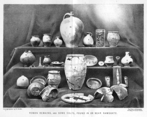
Photograph of artefacts found in or near the Ramsgate area published by Robert Hicks MRCS in 1878
Following on from the image of a Roman burial at Ramsgate from VM_365 Day 56, today’s picture shows a collection of archaeological artefacts from private collections that were discovered in Ramsgate before the photograph was published in an article for Archaeologia Cantiana, the journal of the Kent Archaeological Society, in 1878.
Ramsgate was lucky to have one of Thanet’s most diligent and learned pioneering archaeologists in Robert Hicks, a surgeon who joined Ramsgate’s Seaman’s Infirmary & General Hospital in the middle of the 19th century and maintained a keen interest in the local archaeological discoveries that were being made as the town expanded. Hicks deserves to better known in the story of Ramsgate’s cultural heritage and it would serve the town well if more biographical details could be added to his own story by some local researcher.
Robert Hicks oversaw the collection and photographing of the artefacts and and wrote the article that it illustrated. To accompany the picture in the published article, reproduced in the image above, Hicks listed the location where each of these finds was made, giving a brief description and dates for each of them as current archaeological knowledge stood.
While his focus in the article was predominantly in the abundant finds of the Roman period, several of the artefacts shown in the picture published in the 1878 article are certainly from earlier periods in prehistory, including Mesolithic, Neolithic and Bronze Age axes and what seems to be a finely made Early Bronze Age flint dagger. Two Iron Age fibula brooches are present, along with several late Iron Age ‘Belgic’ pottery vessels.
Sadly none of these artefacts can be located today and Ramsgate’s heritage is poorer for the loss of a collection of artefacts that would grace any local museum and would contribute to telling a longer and more complex story of the area than is generally known to the town’s residents. Now only Hicks’s published photograph exists to help us understand what we have lost.
Reference
Hicks R. 1878. Roman Remains from Ramsgate. Archaeologia Cantiana Vol.12, p.14 – 18.
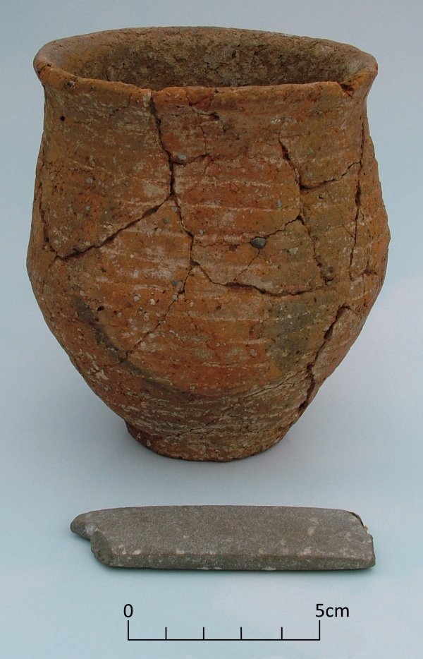
Today’s image is of a stone archer’s wristguard accompanying a Beaker vessel found in an Early Bronze Age round barrow at St Peters, Broadstairs.
The wristguard, made from non local mudstone, and Beaker were found in excavations at the St Peter’s Refuse tip site between 1969-1971 where an important Anglo Saxon cemetery was also excavated.
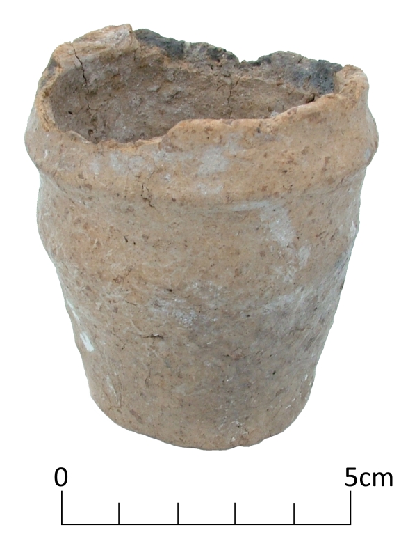
An unusual Early Bronze Age miniature collared urn discovered in the North Foreland area of Broadstairs is shown in our image for VM_365 today.
While building a house on a plot in North Foreland Avenue in 1979, workmen rescued the tiny vessel from a pit after they had uncovered the ring ditch of a round barrow. Rescue excavations on the site traced part of the ring ditch as well as human remains from a later period within the same site, representing at least five Iron Age burials.
The Collared Urn, which has an estimated date range of 2000 – 1500 BC, is one of a few examples of tiny versions of these vessels that have been found in Britain. The urn may have been placed in the central burial of the barrow, which had already been built over when archaeologists investigated the site.
Miniature vessels like this may be token representations of their full size counterparts, used as a substitute in certain cultural conditions, or they may represent the smaller end of a range of functional vessels, collared cups rather than urns.
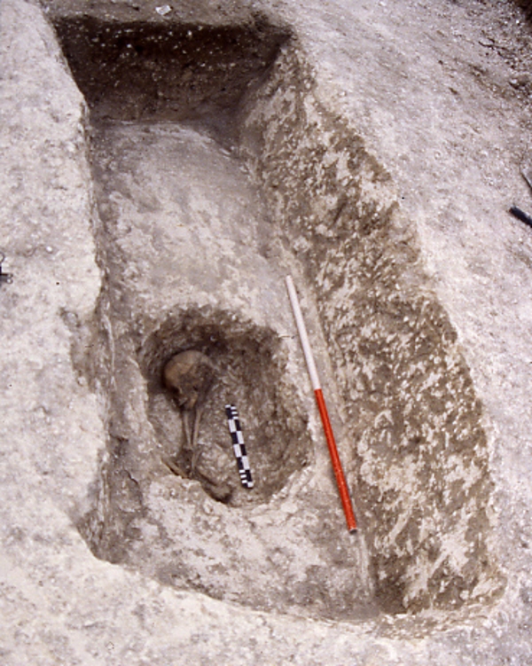
Can we find out who this person buried in the ditch of a round barrow was?
What drives our interest in following the trail of evidence from aerial photographs to the archaeology in ground that has been shown in the VM 365 images over the last few days?
The image for Day 30 of the VM 365 project shows a human skeleton, a young adult that was buried in a small grave that was excavated into the terminal of the round barrow that was shown in yesterday’s image. The grave fill overlying the skeleton was covered with a large fragment of whale rib.
Rather than focus on the excitement of the excavation process that revealed this burial, we should pay attention to the motivation for carrying out the investigation which is often overwhelmed by the excitement about the external character of the results.
The fundamental reason for developing the methods of archaeological investigation was, and remains, curiosity about the places we live in and about the people who have occupied the same places in the past. There are no written records describing the circumstances and experiences of life in periods such as the Bronze Age which are represented in such abundance in the Isle of Thanet. There is no evidence that emanates from their direct experience, which could be used to reconstruct their lives. The people under investigation in these circumstances are truly pre-historic, we lack any tools but archaeological methods to generate knowledge about them and to create narratives of the events that affected them.
Our interest in the universal set of questions, who, where, what, why, and when will not rest for lack of easy evidence and careful exploration and analysis can be used to describe the circumstances of discovery in ever greater detail. Once we understand as much as we can about the circumstances of discovery, and describe them with as much precision as possible, we can begin to interpret the meaning of the things we have discovered. Archaeological investigation must also be used to established the limits of our knowledge. If we take careful note of the present conditions of our discoveries we can begin to understand that many things that are lost from the image of the past we can generate.
Archaeology is about exploring the deliberate construction of messages by people in the past, the signal, as well as the inadvertent or deliberate destructive processes that can distort part of the message, the noise. To produce good and thoughtful interpretation; assumptions should be questioned; different perspectives adopted on the data and our ideas subjected to critical review.
There is always something new to said and new information that can be gathered from the evidence collected by archaeologists. In the case of this burial, its inclusion in a research programme investigating Isotopic data that can be extracted from the teeth will in due course add more to the constellation of knowledge that gathers around the physical remains we recover from excavations.
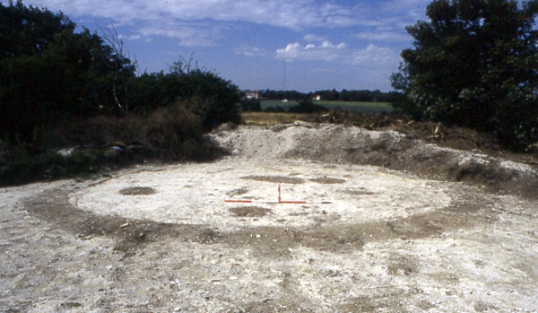
Circular ditch at North Foreland, Broadstairs showing in chalk geology after plough soil has been removed.
We know from the image in Day 28 of VM_365 that the locations of the prehistoric burial mounds of Neolithic and Bronze Age Thanet can still be traced from the influence they have on the growth of the crops in the fields that lie over them.
Today’s image, taken at a site at North Foreland near Broadstairs, shows what happens when the thin skim of plough soil that overlies the ditches is removed by archaeologists, using a combination of a carefully controlled mechanical excavator and a final clean up using hand tools.
Once the earth filled ditches and pits underlying the plough soil has been exposed, planning and recording can take place before any further excavation is carried out to examine how deep the surviving ditches may be, and to recover any finds that can help to give a date for the feature.
Careful attention is paid to the irregular patches of dark soil that are enclosed within the ditch because these may be contain the burials that were marked by the ring ditches and their associated mounds as enduring features in the landscape . Other burials were often inserted later, when the mound and ditch surrounding the burial had become a familiar feature in the landscape.
At this stage an archaeological site which was previously known only through images holds the potential to produce physical evidence for the past.