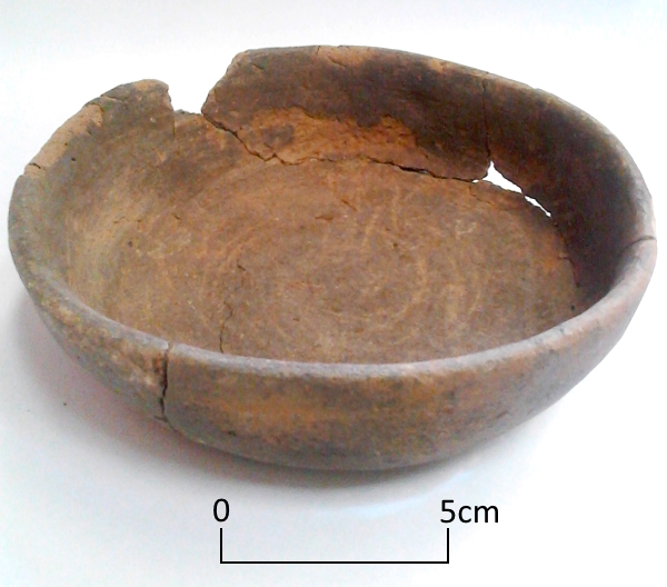
Today’s image shows a handmade, straight sided dish that was found in a Roman grave at Ramsgate. The dish, made from grog and quartz sand tempered fabric with a few shell inclusions, had been heavily used before it was placed in the grave at the feet of a young woman aged between 18-25 years along with two other vessels.
There are many questions we would like to ask when we find objects in these circumstances:
Did this vessel belong to the occupant of the grave or to a family member? What did she use the dish for? Did she use it for eating from or did she use it in cooking, perhaps to make pies* or other meals? Were the knife marks in the base made by her?
Despite all our efforts archaeology may not be able to answer these questions from the evidence that remains.
*Pies are mentioned in a collection of cookery recipes, Apicius, believed to date from the late 4th to 5th centuries.
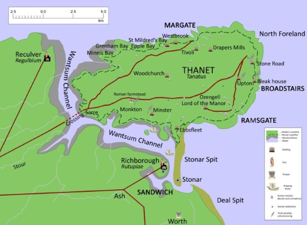
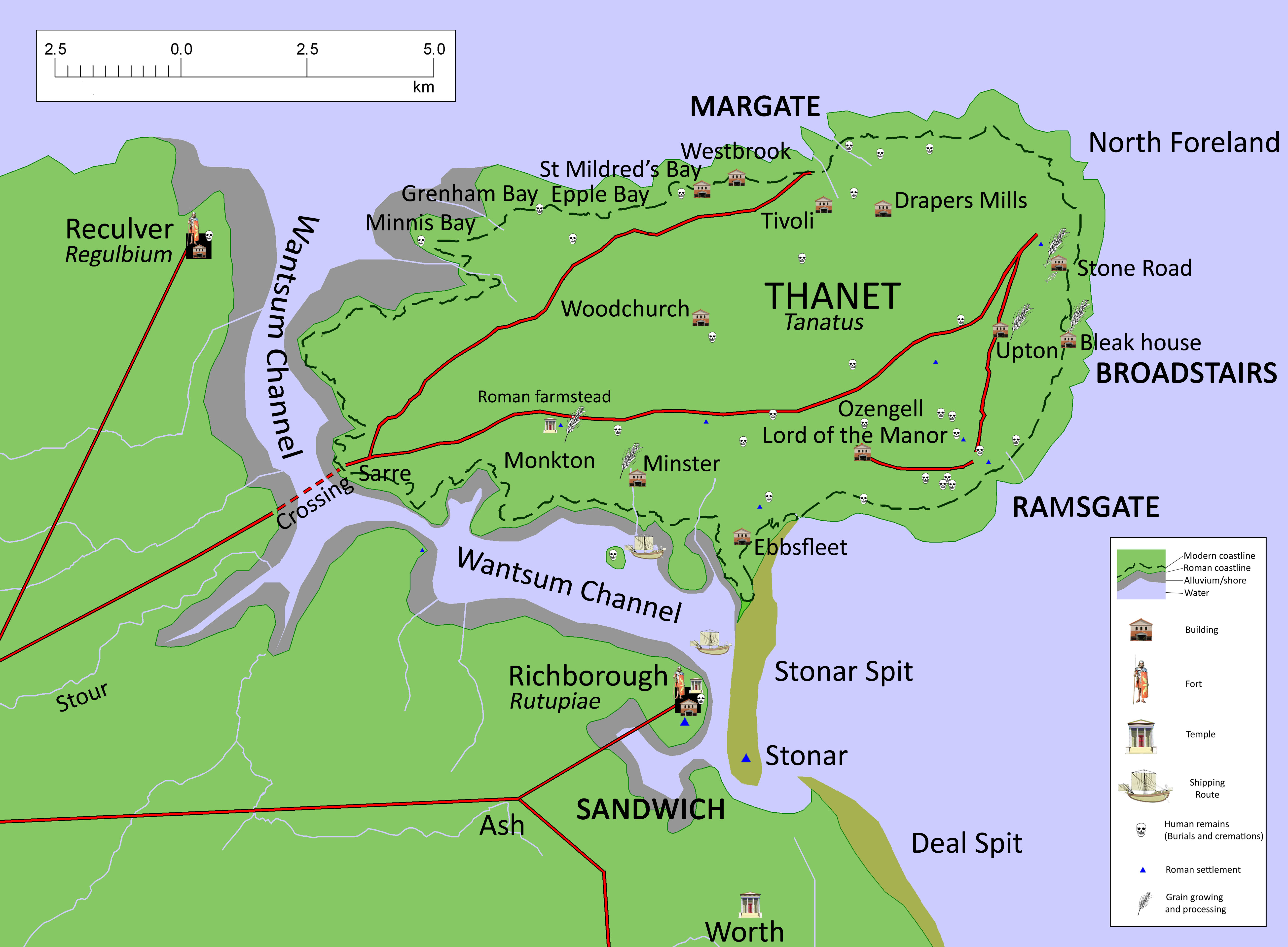
Today’s image for Day 61 of the VM_365 project shows a map of Roman Thanet that was produced to accompany an exhibition called Roman Thanet Revealed, which was curated by volunteers and was on display at the Powell-Cotton Museum in Birchington from April to October 2011.
The map showed an up to date list of major Roman sites that have been identified on Thanet, including the new buildings that had recently been discovered at Upton, Stone Road and Fort House, Broadstairs (shown as Bleak House on the map), as well as the villa at Minster. The map was created to illustrate the locations of the various items on show and to place the discoveries into the context of the networks of roads, towns and forts that would have formed the central places in the Romano-British community.
A map like this serves a number of purposes. It records the location of the discoveries that have been made by archaeologists in specific locations, but it also allows connections to made between the sites and the landscape that they stand in which helps to create a narrative of similarities and differences within the period and to suggest interactions between types of sites and locations .
Recent research has shown in detail the changes that must have taken place in the coastline of Thanet since the Roman period and this map suggests where the Roman coast line might have been. Archaeological evidence in the form of recently rediscovered records and finds from a Roman cremation burial and structure from Boxlees Hill within the channel, show clearly that the Wantsum Channel which separated the Isle of Thanet from the mainland of Kent was not as open and navigable as was once thought. It is shown in the map with a wide margin of tidal silts with only the central channel open to the passage of ships.
Several recently published histories of Roman Britain have underestimated the density of settlement in Thanet in the Late Iron Age and Roman period, perhaps because some sites have remained unpublished and also because there is no permanent place to show and promote Thanet’s archaeological remains. As the Roman Thanet Revealed exhibition ended, our Roman history went once more into relative obscurity.
Further reading:
The ancient landscape of Thanet from the Ice Age to the Anglo-Saxon period is explored through a series of revealing historic maps of Thanet and new reconstructions based on geological and archaeological detective work in the book St. Augustine’s First Footfall which is published by the Trust for Thanet Archaeology.
The story of Thanet’s Archaeology from Prehistory to the Norman Conquest was explored by the Ges Moody of the Trust, using a series of maps and archaeological evidence. The Isle of Thanet from Prehistory to the Norman Conquest is available from all high street bookshops and online book-sellers.
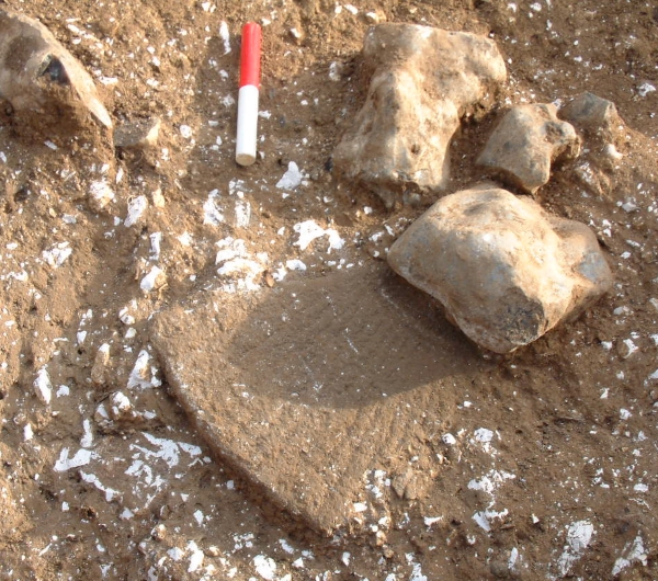
3rd century Roman millstone fragment from Upton, Broadstairs
Todays VM_365 image comes from the excavation of a Roman period cellar at Upton, near Broadstairs, one of the three areas where the Trust has established the presence of Roman building remains in Broadstairs in the last decade. Like the sites at Stone Road and Fort Hill, nothing remained of the structures that would have been above ground level at the Upton site.
To undertand what the cellared buildings we have located might have been we need to look closely at the finds that are associated with them, to gain some context and to be able interpret the uses they were put to. In both the building at Upton and at Stone Road large pieces of finely dressed millstones were found. The one in the image above was around 50mm thick, the upper surface had been dressed with an even pecking all over, the lower face had a series of teeth cut into the surface radiating from the 100mm diameter central hole. The whole millstone had a diameter of approximately 0.83m. Stones like this would have been large and heavy and while it is possible they were worked by hand, it would have taken considerable effort and perhaps animal power might have been used to drive them.
In the future perhaps research and observation of communities that still use similar millstone as well as experimental archaeological methods could give a greater insight into the quantity and quality of the flour that could be produced and perhaps the food that could be made with it.
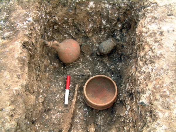
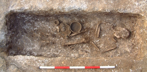
Following on from Day 56’s image of one of the Roman graves excavated at Grange Road, Ramsgate, today’s image shows one of the grave assemblages from the same site.
This assemblage was found in the grave of an adult female who was buried wearing a copper alloy twisted wire bracelet and was wearing foot wear with hobnails. The assemblage you can see in this picture was found at the foot end of the grave and included a second copper alloy bracelet, a pottery dish, a flagon stoppered with a flint and a beaker. If you look carefully, you can also see a length of copper alloy wire, near the dish that may have been twisted around a fabric bag.
It was items like this that Hicks was recovering in the new developments in this area of the town in the 19th century.
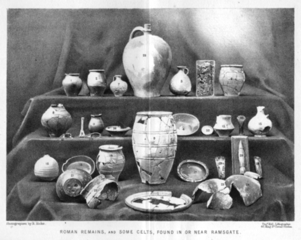
Photograph of artefacts found in or near the Ramsgate area published by Robert Hicks MRCS in 1878
Following on from the image of a Roman burial at Ramsgate from VM_365 Day 56, today’s picture shows a collection of archaeological artefacts from private collections that were discovered in Ramsgate before the photograph was published in an article for Archaeologia Cantiana, the journal of the Kent Archaeological Society, in 1878.
Ramsgate was lucky to have one of Thanet’s most diligent and learned pioneering archaeologists in Robert Hicks, a surgeon who joined Ramsgate’s Seaman’s Infirmary & General Hospital in the middle of the 19th century and maintained a keen interest in the local archaeological discoveries that were being made as the town expanded. Hicks deserves to better known in the story of Ramsgate’s cultural heritage and it would serve the town well if more biographical details could be added to his own story by some local researcher.
Robert Hicks oversaw the collection and photographing of the artefacts and and wrote the article that it illustrated. To accompany the picture in the published article, reproduced in the image above, Hicks listed the location where each of these finds was made, giving a brief description and dates for each of them as current archaeological knowledge stood.
While his focus in the article was predominantly in the abundant finds of the Roman period, several of the artefacts shown in the picture published in the 1878 article are certainly from earlier periods in prehistory, including Mesolithic, Neolithic and Bronze Age axes and what seems to be a finely made Early Bronze Age flint dagger. Two Iron Age fibula brooches are present, along with several late Iron Age ‘Belgic’ pottery vessels.
Sadly none of these artefacts can be located today and Ramsgate’s heritage is poorer for the loss of a collection of artefacts that would grace any local museum and would contribute to telling a longer and more complex story of the area than is generally known to the town’s residents. Now only Hicks’s published photograph exists to help us understand what we have lost.
Reference
Hicks R. 1878. Roman Remains from Ramsgate. Archaeologia Cantiana Vol.12, p.14 – 18.
Our Image for VM_365 today is of a Roman burial found in Ramsgate, which gave us important evidence confirming the records of early archaeological discoveries in the town.
For much of the 19th century Ramsgate was spreading out from its early limits, clustered along the High Street and around the harbour. Suburbs with bungalows, large houses, terraces and squares began to spread out on the upper reaches of the East and West Cliffs, the town expanding into what had been open fields and parade grounds and camps during the Napoleonic Wars.
In the course of the development that took place, many archaeological sites were disturbed and important evidence of the long occupation of the area was revealed. Luckily Ramsgate in the 19th century was home to a lively community of local historians and pioneering archaeologists and many documentary and even photographic records were made and published.
Several Roman burials had been reported on the West Cliff, in the area of the southern end of Grange Road, London Road and West Cliff Road, suggesting that the West Cliffs were the site of groups of Roman burials if not a more extensive cemetery.
Unfortunately few of the artefacts or sites could be re-examined using modern archaeological methods and the interpretation and dating given by the early researchers could not be tested. Much of the evidence could only be regarded as ‘background’ information which could not be taken at face value until more data could be gathered. What was needed was archaeological evidence that could be analysed using modern methods and allow a more accurate assessment to be made of the early records.
In 2007 an excavation at a site in Grange Road provided the archaeological confirmation that was needed when a group of five intact graves were discovered, surviving remarkably just beneath the foundations of a demolished building that had been cleared from the site.
The five graves could be excavated using modern methods and the accompanying finds analysed in detail and accurately dated, showing that the group dated to the late 3rd or early 4th century. Without doubt more remains to be found of Roman Ramsgate. Records suggest that a Roman building once stood near the harbour and archaeological confirmation of the settlement where these Roman people lived would put Ramsgate firmly on the map of Roman Britain.
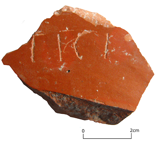
Personal name scratched into the surface of a Central Gaulish Samian dish from Broadstairs
Who were the people that lived in Thanet in ancient times?
We can never know anything about a large number of them, who have left neither written records or are represented by their remains. Occasionally some small remnant of their identity is asserted in some way through an archaeological find.
Our Image for VM_365 today shows one of those tiny echoes of a person who may have lived near Broadstairs in the Roman period in the 2nd century AD.
This fragment of a dish in Central Gaulish samian fabric (Drag. 18/31 R), dating from the early to Mid 2nd century, is marked with scratched letters reading TICI, probably part of the owners name. The sherd was found in the remains of a Roman building on the cliffs above Viking Bay in Broadstairs. Samian vessels could be large and these fine tablewares were probably expensive to replace and were often marked with names, scratched by hand into the glossy surface of the vessel.
Although we are lucky to have increasing numbers of written fragments dating from the Roman period in Britain, even sets of letters and accounts from one site, this small body of writing can only hint at the many ways that the skill of literacy might have been used in the Roman period.
In this case the writer used his skill to identify an object as his own and this act is preserved in a remarkable and rare survival into our own age.
The flint lined cellar cut into chalk hillside overlooking Viking Bay
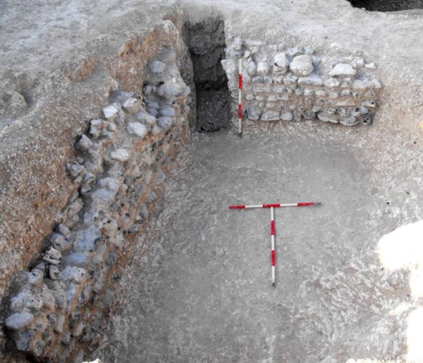
Before the building at Stone Road that featured in yesterday’s VM 365 post was discovered, there were few confirmed archaeological sites of Roman date in the Broadstairs area. Only a few years later, in 2009, a second building was discovered, on the south facing slope of the chalk ridge that forms the northern side of Viking Bay. The site was adjacent to the historic Fort House, which stands on the crest of the promontory overlooking the sea to the east. In the mid 19th century Charles Dickens and his family rented Fort House on several occasions for extended stays, from where it derives its current name of Bleak House.
On the site of a new house which was to be partly terraced into the chalk slope, a number of large soil filled features were found cutting into the surface of the solid chalk geology. The whole site had been heavily truncated by terracing to form platforms for gardens and at one time an orchard.
Excavation revealed that the the pits were in fact large cellars which had been excavated below buildings that once stood on the surface of the chalk, although nothing of these surface structure remained to be recorded. Although two of the cellars seem probably to have been lined with timbers, one had a flat ledge cut around two sides which supported several surviving courses of large water rolled flints, occasionally interspersed with thick flat sherds of Roman amphora.
The wall shown on left side of the image was divided into two sections by a huge nodular flint, which may have supported a post of the structure above. The upper levels of the wall had been destroyed and robbed of its stone, part of the wall had been removed by an engineering test trench excavated before the archaeological investigation began.
Although there had been a great deal of damage to whatever Roman building once stood here, some complex sequences of deposits survived to show that the history of the building was complex and once again hinted at a more complicated story that may not be possible to reconstruct in detail. Almost all the finds associated with the structure were found in the fill of a ditch that had been cut through a gritty sand deposit which had filled the void of the cellar.
Some of these finds will be explored in later VM 365 posts.
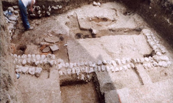
Basement room, almost all that survived of a Roman Villa at Stone Road, Broadstairs.
The North Foreland promontory is separated from the downland slopes further to the south by a dry valley, which falls to the cliff line near Stone Bay. In recent time a cutting was made through the cliffs, forming steps and a steep ramp to reach the present shore. In the Roman period there may have been a more gentle slope through the base of the valley, leading to a natural bay located further to the east, which has since been destroyed by coastal erosion.
In the 1920’s O.G.S, Crawford, the great pioneer of British archaeological survey, noted that earthworks and Roman pottery had been found on patch of open downland at Stone Gap , to the north of Broadstairs. No further investigation of the site seems to have taken place before the growing suburbs of Broadstairs eventually enclosed the location within the garden of a bungalow. No attention was drawn to the record of the Roman finds made by Crawford again.
In 2004, the large garden of the bungalow was divided and part was sold to be the location of a new house, to fronting Bishop’s Avenue near its junction with Stone Road. In an archaeological evaluation trench on the site a few scraps of painted plaster were found, with a few Roman and late Iron Age pottery sherds, along with a row of rounded flint cobbles which appeared to be part of a wall. A larger area excavation had to be carried out, which was not an easy task in the very limited space.
Below the deep layer of garden soil that had been distributed over the site to level it, the remains of the basement of a Roman building, an overview of which is shown in today’s image, were uncovered.
The basement had been cut into deep drifts of plough soil which had accumulated on the sloping valley side. The pottery sherds within this soil were almost exclusively of Iron Age date, probably debris from the extensive North Foreland settlement which lies only a short distance to the north of the site. The sides of the rectangular cutting into the soil were lined with large water rolled flint cobbles, bonded with a chalky clay paste.
Many more small painted wall plaster fragments were found in the thin layer of demolition deposits that had been trapped within the rectangular area enclosed by the rounded cobble walls. The lower layers of flooring were revealed to be thick spreads of beaten chalk of variable depth, which sealed two infant burials in one area. The floors seem to have been repaired a number of times in association with the construction and then abandonment of a series of small kilns, which had been fuelled by burning chaff, the fibrous husks separated from harvested grain.
In the latest floor surfaces two more substantial kilns or ovens had been built, the soot from the latest was spread over the clay of the last floor surface. Within the soot a military belt buckle and other small metal items including a spoon, were found, suggesting that clothes or timbers with fittings still attached had been used to fuel the oven.
The Stone Road building provides an intriguing glimpse of a moment in history which can not be fully narrated, but nevertheless generates many associations and speculations. With the limited access to the space in the area of the building and the heavy toll of erosion and damage from subsequent construction work, further archaeological investigation in the future may never be able to answer the many questions raised by this remarkable discovery.
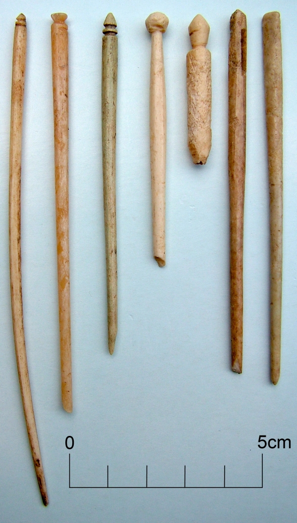
Bone and ivory pins, personal items from a Roman Villa
While some of these bone and ivory pins are undoubtedly personal objects, used as hair pins and possibly for fastening clothes, these fragile objects from the Roman Villa at Minster in Thanet may also reflect the enormous variety of crafts and industries that were carried out in and around the Villa.
Some pins and broken fragments of pins which have eyes through in the upper part of the shaft, are probably large needles. Being made of such a brittle material they were perhaps used to stitch together soft woollen cloth, perhaps in a process associated with weaving, or perhaps they may have been used to make and mend nets.
Similar straight wood and ivory pins with their carefully carved terminals can be found among the bobbins of lacemaker’s tool kits in the present day, although there seems to be no direct evidence of Roman lacemaking.