Return to Roundbarrows Display
Display Contents
Ring-ditches and roundbarrows of Thanet - Section 5
Section 1
Introduction
The numbers game
Section 2
Characterising the distribution
Section 3
A new review
New discoveries/old
Coastal erosion
An estimated total
Section 4
Position
Population
Observations
Section 5
Causewayed ditches
Dating
Significance
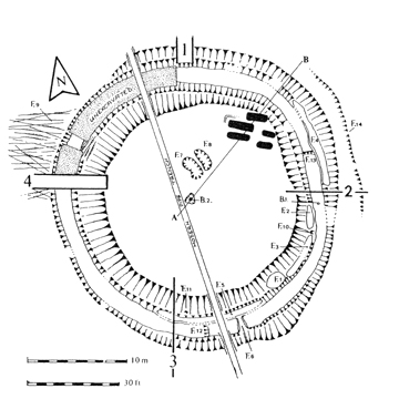
Plan of Lord of the Manor III (TAU)
A Late Neolithic enclosure re-used in the Early Bronze Age
Causewayed ring-ditches
and roundbarrows
Twelve Causewayed ring-ditches and
roundbarrows are known to have been excavated on Thanet. Dated examples
range from the Late Neolithic to the Middle Bronze Age.
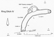
This does not include the
monument defined as Monkton-Minster A253
ring-ditch IV in Fisk (2003). This was only part revealed in the
excavation and is not certainly a ring-ditch at all.
Should it be one
then the monument features a very broad causeway and in plan may be
more of a horse shoe-shaped enclosure (see below left).
In some cases the causeways probably relate to an early phase in a monuments multi-period history, where a space initially demarcated for ceremonial activities has latterly been converted into a burial monument - a roundbarrow.
In some cases the causeways probably relate to an early phase in a monuments multi-period history, where a space initially demarcated for ceremonial activities has latterly been converted into a burial monument - a roundbarrow.
Copyright Canterbury Archaeological Trust
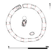
Plan of the Causewayed roundbarrow North Foreland III discovered at North Foreland, Broadstairs
(TTA)
Five of the causeways of these monuments have been (or are likely to have been) slighted at the end of their life, being cut down as an act of 'closure', perhaps at the conclusion of any burial phase.
An interesting trend can be seen in the shape of grave cuts. It appears that central, primary, inhumations are always in rectangular-shaped grave cuts, while the outer burials are frequently within oval graves or much more rounded/sub-rectangular graves. This trend is paralleled generally in the roundbarrow tradition on Thanet.
Click
here to explore the phenomena of the Causewayed monuments further (including a Gazetteer with
some links to additional Displays on the individual sites).
Radiocarbon dates have been obtained
from several burials associated
with Thanet roundbarrows. These are listed below (along with their %
confidence rating where known and the lab reference code).
(i) Manston Runway Approach.
Beaker inhumation burial.
2120-2080 BC (68%) or 2132-1922 BC (68%)
/ 2140 - 1885 BC (95%).
(BM-2642).
(ii) South Dumpton Down.
Multiple Beaker/Food Vessel inhumation burial.
Burial 1:
2120-2080 BC (68%) / 2135-1895 BC (95%).
(BM-2975).
Burial 3:
2020-2000 BC (68%) / 2100-2085 BC (95%).
(BM-2940).
Burial 5:
1920-1870 BC (68%) / 1965-1745 BC (95%).
(BM-2864).
(iii) Lord of the Manor VII.
Central inhumation burial.
2131-1922 BC.
(BM-2642).
(iv) Beauforts, North Foreland Avenue. Beaker inhumation burial.
2290-2190 BC (64.3%) / 2350-2130 BC (95.4%).
(Wk 18732).
(v) Monkton-Minster A253.
Soot from a Trevisker Urn placed in ring-ditch.
1600-1320 BC.
(OxA 6141).
(vi) Bon Secours, Ramsgate.
Deverel-Rimbury cremation outside barrow.
1450-1380 BC (57.4%) / 1520-1310 BC (95.4%).
(Wk 15116).
Dr. David Perkins (1999)
In 1999 the culmination of Dr. David Perkins' studies into the Thanet barrow landscape led him to conclude that East Kent's two distinct barrow concentrations of the Isle of Thanet and the 'Sutton Wedge'
'are directly comparable with the more densely barrow-populated areas of Wessex' (Perkins 1999, 49).
In exploring this point he
showed that the area extending
10km around Stonehenge was known to contain 333 barrows in 414 sq km.
This was a
density of 0.80 barrows per sq km.
The 'Sutton Wedge' had 356 roundbarrows and ring-ditches within an area of 234 sq km - a density of 1.52 per sq km (Perkins 1999).
At that time (1999) Thanet had at least 380 roundbarrows and ring-ditches (the vast majority of which were likely to be roundbarrows) in 64 sq km - a density of 5.89 per sq km.
Figures obtained from the current review now suggest that Thanet has at least 480 roundbarrows and ring-ditch monuments in an overall area of 86.31 sq km - a density of 5.56 per sq km. This figure includes all of the Isle's urban areas within its calculation, estimated at comprising 33.64 sq km. If one concentrates on areas solely capable of cropmark formation then the monument density figure becomes a much more accurate 9.11 per sq km.
As Dr. Perkins had already
pointed out in 1999
-
'the Thanet landscape seems to have no equal in terms of density'!
'the Thanet landscape seems to have no equal in terms of density'!
ASE - Archaeology South East.
KARU - Kent Archaeological Rescue Unit.
RCHME - Royal Commission on the Historical Monuments of England.
TAU - Thanet Archaeological Unit.
TTA - Trust for Thanet Archaeology.
WA - Wessex Archaeology.
Cunliffe B. 1993. Wessex to AD 1000. Longmans, London.
Fisk P.M. 2003. An examination of the excavated ring ditch enclosures on The Isle of Thanet. Unpublished Degree thesis.
Perkins D.R.J. 1987. Eroding History. A Report to English Heritage. Trust for Thanet Archaeology.
Perkins D.R.J. 1999. A Gateway Island. Unpublished Doctoral thesis.
Dr. Dave Perkins
at St. Stephen's College (NFB99)
Acknowledgments
The body of this work is founded on the extensive research conducted over many years by the former Director of the Trust for Thanet Archaeology - Dr. Dave Perkins.
His work has highlighted the importance of this particular aspect of our Prehistoric heritage and we are indebted to him.
I should also like to acknowledge the work of Nigel Macpherson Grant for his excavations (along with Dave Perkins) of the numerous and fascinating ring-ditch monuments at Lord of the Manor.
Much
thanks also goes to Pip Fisk for her work on compiling a thorough,
comprehensive and
invaluable
gazetteer of
the
roundbarrow and ring-ditch monuments excavated on Thanet.
Great effort was made by her to gather as much published and unpublished information as possible and her work has been (and continues to be) the 'one-stop-shop' for research into these matters. The time which has been saved by consulting this document is immeasureable and it has had a profound impact on the labour taken to make the observations and presentations of the ring-ditch phenomena published here.
Great effort was made by her to gather as much published and unpublished information as possible and her work has been (and continues to be) the 'one-stop-shop' for research into these matters. The time which has been saved by consulting this document is immeasureable and it has had a profound impact on the labour taken to make the observations and presentations of the ring-ditch phenomena published here.
Mr. John Villette excavating an Anglo-Saxon SFB next to the QEQM Hospital Margate
He is keen to see some details published about the important discoveries made at this site and I am glad that this current work provides an opportunity to bring a record of its existence into the public domain. More information will hopefully be forthcoming in the future.
The publishing of archaeological investigations is frequently at the mercy of circumstances beyond the control of those who undertake the work, even in todays commercial archaeological operations.
Where comprehensive publication is lacking or impossible due to financial constraints, it is important that at least some summary 'Statement of Existence' can be made (as has now been achieved here, with more information to follow in the future hopefully). At the heart of the subject this is probably the most important thing.
Paul
Hart
Version 1 - Posted 10.08.06
Version 2 - Posted 21.10.06
Version 3 - Posted 16.12.06
Version 1 - Posted 10.08.06
Version 2 - Posted 21.10.06
Version 3 - Posted 16.12.06
All
content © Trust for Thanet Archaeology