Return to Roundbarrows Display
Display Contents
Ring-ditches and roundbarrows of Thanet - Section 1
Section 1
Introduction
The numbers game
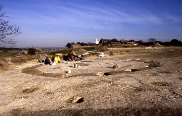
The small Causewayed roundbarrow North Foreland III discovered at the former St. Stephen's College site, North Foreland, Broadstairs
Characterising the distribution
Section 3
A new review
New discoveries/old
Coastal erosion
An estimated total
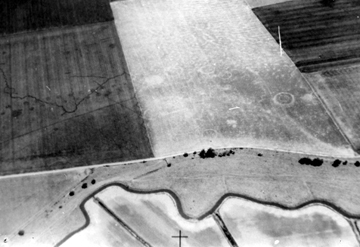
Aerial photographs of
Thanet's fertile agricultural lands have helped to reveal the hidden
history of the Isle, demonstrating the rich archaeological legacy
created by our ancestors.
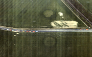
These aerial photographs (APs) have shown that Thanet has a large number of ring-ditch monuments, the vast majority representing Bronze Age roundbarrows. The ring-ditches appear in single, double and triple-concentric ring forms; the multiple rings resulting from the re-use and refurbishment of earlier monuments.
These aerial photographs (APs) have shown that Thanet has a large number of ring-ditch monuments, the vast majority representing Bronze Age roundbarrows. The ring-ditches appear in single, double and triple-concentric ring forms; the multiple rings resulting from the re-use and refurbishment of earlier monuments.
Position
Population
Observations
Section 5
Causewayed ditches
Dating
Significance
While the best efforts have always been made to identify and plot the ring-ditch monuments from (frequently oblique) APs, it is not possible to present a single, unarguable figure or plan of the total number of these monuments present in the landscape.
Cropmarks are dependant on the underlying soil type, the ground cover or vegetation, agriculture and the changing seasons.
What we can say is that the data
revealed in these ongoing studies
represents the minimum baseline figures for Thanet's roundbarrows -
an impressive statistic in itself!
Photographer unknown
- A survey by the Air Photography Unit of the Royal Commission on the Historical Monuments of England (RCHME) resulted in the publication of a series of maps and a report (1989) on cropmark data from Kent and Thanet.
- The RCHME survey formed the basis for work conducted by David Perkins who researched Thanet's roundbarrow landscape for his Doctoral Thesis (1999). He also augmented the data by reviewing other sources of aerial photographs, including those taken by private individuals and the Potato Marketing Board, while adding information on lost barrows recorded in written sources over the last couple of hundred years. The data presented in his survey does not include any monuments that could be identified as enclosures rather than potential roundbarrows or those likely to be Anglo-Saxon in origin.
- In 2003 Mrs P.M. Fisk made another vital contribution in compiling a comprehensive Gazetteer of 43 ring-ditch and roundbarrow sites excavated on Thanet. This was done as a dissertation for her Degree in Archaeology at the University of Kent at Canterbury.
Photographer unknown
The RCHME survey of Kent (1989) reported the following cropmark sites:
Concentric BA
ring-ditches: 50
Single BA ring-ditches with internal features: 73
Single BA ring-ditches without internal features: 518
EMED* (ie Saxon) ring ditches with internal features: 30
EMED* (ie Saxon) ring ditches with internal features: 169
Single BA ring-ditches with internal features: 73
Single BA ring-ditches without internal features: 518
EMED* (ie Saxon) ring ditches with internal features: 30
EMED* (ie Saxon) ring ditches with internal features: 169
* in this report it was decided that ring-ditches less than 10m in diameter were provisionally dated as Early Medieval (ie. Saxon), while diameters of 10-30m were dated as Bronze Age.
356
(48.2%) of these
fall within East
Kent's
'Sutton
wedge'. This is an area of 234 square km which shows a high
concentration of
archaeological sites and has the village of Sutton
at its centre.
315 (42.6%) appear in Thanet, contained within an area of only approximately 64 square km.
68 (9.2%) can be seen in the rest of Kent; mostly on high ground west of the Medway.
315 (42.6%) appear in Thanet, contained within an area of only approximately 64 square km.
68 (9.2%) can be seen in the rest of Kent; mostly on high ground west of the Medway.
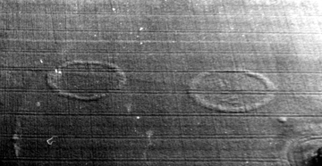
Ring-ditch cropmarks
at Lord of the Manor, Ramsgate
Photographer unknown
Not
all soils or types of ground-cover
are conducive to the formation and identification of cropmarks of
course and much
may remain concealed or have been destroyed by subsequent development.
Peter Clark (pers comm.) noted that Canterbury Trust's excavations on the Monkton-Minster A253 road scheme (1993) revealed the presence of more roundbarrow monuments than had been indicated by the cropmark data (despite the fact that the underlying chalk geology usually provides the best circumstances for cropmark formation).
Dr. David Perkins' comprehensive study (1999) reviewed aerial photographs from several different sources and this revealed more ring-ditches than had been seen in a published RCHME survey. In comparing Perkins' plan of Thanet's ring-ditch cropmarks with the RCHME plots it can been seen that within some 500 square metre locations he had discovered up to six extra ring-ditch cropmarks.
This all helps to illustrate that the statistics concerning Thanet's roundbarrow archaeology must be taken in context and viewed as minimum estimates only.
Paul
Hart
Version 1 : Posted 10.08.06
Version 2 : Posted 21.10.06
Version 1 : Posted 10.08.06
Version 2 : Posted 21.10.06
All
content © Trust for Thanet Archaeology