Display Contents
Ring-ditches and roundbarrows of Thanet - Section 2
Section 1
Introduction
The numbers game
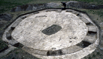
The Manston Runway Approach Beaker barrow
Scale in 0.1 metre divisions
Photograph by TAU (photographer unknown)
Characterising the distribution
Section 3
A new review
New discoveries/old
Coastal erosion
An estimated total
Section 4
Position
Population
Observations
Section 5
Causewayed ditches
Dating
Significance
In his survey of Thanet's
roundbarrows Dr. Perkins (1999) sought to
characterise their distribution across the Island's landscape. A brief
summary of his findings are presented below:
(I) Single barrows
This category accounts for 59 (15%) of Thanet's barrow cropmarks. Over half of the double and triple ring-ditch barrows occur in isolation. When they occur in cemeteries they are either at the center or the end of a linear concentration.
(I) Single barrows
This category accounts for 59 (15%) of Thanet's barrow cropmarks. Over half of the double and triple ring-ditch barrows occur in isolation. When they occur in cemeteries they are either at the center or the end of a linear concentration.
This suggests that they may have
provided a focus
for later barrow-builders (Perkins 1999).
Top
(II) Barrow
groups
Three
or more barrows, no more than 200m apart, with a maximum
joining distance of 300m.
There are 22 barrow groups, comprising
between 3 and 10
barrows. Fourteen are situated on west or south-west facing downland
slopes
overlooking a valley or the coast. Six lie on the fairly level ground
of
Thanet's central plateau.
One group at Minnis Bay is on low ground
close to the shoreline and would have originally been only a few
hundred meters from the sea.
These groups could indicate a favoured
location, such as a
hilltop or ridge. Their arrangement may respect a tradition or relate
to territorial boundaries (Perkins 1999).
Five
or more barrows no more than 100m apart, with a maximum
joining distance of 200m.
Thanet has 18 barrow cemeteries,
containing between 5 and 33 barrows.
They are generally sited on west or south-west facing downland slopes.
Only 2 are found on north-east facing slopes. Four appear on
the
flat central plateau.
These may represent a continued use of a
designated area by a populous
peripheral community or settlement (Perkins 1999).
These are concentrated clusters of
groups and cemeteries
occupying distinct geology and topography.
There are 6 large clusters. These
contain most of the Island's 40 cemeteries and groups. Only 4
cemeteries and 6 groups appear isolated.
The 6 super cemeteries are located at :
(i) Monkton-Minster.
(ii) Minnis Bay-Brooksend.
(iii) Dane Valley-Foreness.
(iv) Ozengell-Pegwell.
(v) St. Nicholas.
(vi) Shottendane Valley.
Scheduled Ancient Monuments at Great Brooksend Farm
Photographer unknown
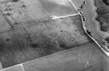
TAU - Thanet Archaeological Unit.
Paul
Hart
Version 1 - Posted 09.08.06
Version 2 - Posted 21.10.06
Version 1 - Posted 09.08.06
Version 2 - Posted 21.10.06
All
content © Trust for Thanet Archaeology