Return to Roundbarrows Display
Display Contents
Ring-ditches and roundbarrows of Thanet - Section 3
Section 1
Introduction
The numbers game
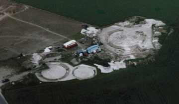
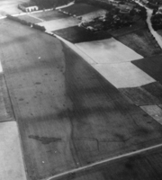
Aerial photograph of the excavations at Lord of the Manor II B, C and D
(TAU; photographer unknown)
Characterising the distribution
Section 3
A new review
New discoveries/old
Coastal erosion
An estimated total
Section 4
Position
Population
Observations
A new review
A new review of Thanet's
ring-ditch cropmarks was recently instigated
by Ges
Moody using the sites which
had originally been identified in
Perkins' 1999 study in an
effort to create an accurate digital map of Thanet's roundbarrow
landscape.
A review of the Perkins data revealed the following statistics for the ring-ditch monuments:
Single ring-ditches: 295*
Possible/probable single ring-ditches: 82
Double ring-ditches: 17
Possible double ring-ditches: 1
Triple ring-ditches: 2
Single ring-ditches <10m diameter: 16**
Total: 413
A review of the Perkins data revealed the following statistics for the ring-ditch monuments:
Single ring-ditches: 295*
Possible/probable single ring-ditches: 82
Double ring-ditches: 17
Possible double ring-ditches: 1
Triple ring-ditches: 2
Single ring-ditches <10m diameter: 16**
Total: 413
Causewayed ditches
Dating
Significance
*Lord of the Manor VIII is
included in this list as a large single
ring-ditch monument, but on excavation was found to have a second
small, shallow, inner ring-ditch (a later addition, which produced a
possible sherd of Beaker pottery) which surrounded a shallow burial.
**The single ring-ditches of less than 10m diameter were originally thought more likely to be of Jutish (Anglo-Saxon) origin. However recent excavations at Bon Secours Ramsgate and Bradstow School Broadstairs have revealed very small single ring-ditch monuments (of 4m and 5.5m diameter respectively) dating to the Bronze Age.
**The single ring-ditches of less than 10m diameter were originally thought more likely to be of Jutish (Anglo-Saxon) origin. However recent excavations at Bon Secours Ramsgate and Bradstow School Broadstairs have revealed very small single ring-ditch monuments (of 4m and 5.5m diameter respectively) dating to the Bronze Age.
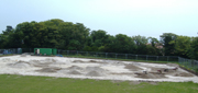
The large, Causewayed ring-ditch monument discovered at Bradstow School, Broadstairs in 2006
It was initially evaluated by the Trust for Thanet Archaeology and subsequently excavated (as shown in the picture above) by Archaeology South East
Since the 1999 survey another 10 ring-ditch monuments are known to have been found during excavations in urban areas. At least 8 of these can be considered certain roundbarrows; the possible exceptions being numbers v and xii (below).
Some new information has also been learned about a site excavated at Mill Lane Margate in 1975 (J.Villette pers comm.); this featured a ring-ditch monument (probably a Henge) which was unknown to the authors of the recent studies (and thus can be considered an additional urban site).
No published information is currently available on this important but un-financed Rescue Excavation, though intentions exist and it is hoped that some form of official publication could be forthcoming.
Another additional site which does not feature on the Perkins plan was discovered at Ebbsfleet (by Wessex Archaeology) in 1994. This comprised a small ring-ditch monument (4m in diameter) which was explored by one section before being unexpectedly covered over. A polished flint axe was recovered from the base of the ditch, while the top fill contained a small sherd of probable Late Bronze Age/Early Iron Age pottery (Hearne, Perkins and Andrew 1995).
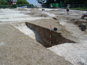
A section through the Causewayed ring-ditch monument now known as Bradstow School IV
(i) Mill Lane Margate (J. Villette,
KARU 1975).*
(ii) Ebbsfleet (WA 1994).*
(iii) Ramsgate Greyhound Stadium (KARU 2000).
(iv) Anne Close I, Birchington (TTA 2001).
(v) Anne Close II, Birchington (TTA 2001).
(vi) Bon Secours, Ramsgate (TTA 2002).
(vii) North Foreland Av, Broadstairs (TTA 2004).*
(viii) Cliffs End Farm I, Cliffsend (WA 2004).*
(ix) Cliffs End Farm II, Cliffsend (WA 2004).*
(x) Cliffs End Farm III, Cliffsend (WA 2004).*
(xi) Bradstow School IV, Broadstairs (TTA 2006).*
(xii) Bradstow School V, Broadstairs (ASE 2006).*
Total: 12
* Not included in or 'Post-Fisk' (2003) sites.
NB. The large ring-ditch Bradstow School IV may have been recognised previously in aerial photographs, though as plotted is close to but not exactly at the same spot as discovered through excavation.
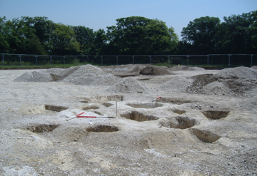
Part of the much larger Causewayed ring-ditch monument can be seen in the background
It has been estimated (Perkins 1987) that Thanet's northern, eastern and southern coasts have been eroding at around 30m each century. This means that over the last 4000 years up to 1.2 km of coast may have been lost - an area of approximately 25.2 square km (9.27 sq miles).
This comprises about 20% of the land area of the original island and will no doubt have destroyed a large number of roundbarrows and other monuments.
Throughout
this work I have
been keen to present the results of all the individual surveys (RCHME
1989, Perkins 1999 and Fisk 2003) prior to the 'new review' in
order to show the evolution of the research and to allow
other researchers access to data that they may prefer to use for
comparative purposes.
The
results of the new review (which is ongoing) are presented
further below.
Oliver Gardner (of the Trust for Thanet
Archaeology) has now completed (as of 06.10.06) the
project of compiling a digitised
map and database which contains the location of (and information on)
all of the known ring-ditch and roundbarrow
monuments on the Isle of Thanet.
It contains data compiled from the surveys undertaken by the RCHME and Dr. David Perkins (including the possible/probable ring-ditch and roundbarrow monuments), as well as P.M. Fisk's gazetteer. The results of the latest research into the excavated ring-ditch and roundbarrow monuments of Thanet has also been added.
It contains data compiled from the surveys undertaken by the RCHME and Dr. David Perkins (including the possible/probable ring-ditch and roundbarrow monuments), as well as P.M. Fisk's gazetteer. The results of the latest research into the excavated ring-ditch and roundbarrow monuments of Thanet has also been added.
Single and multiple ring-ditch cropmarks likely to be BA barrows: 215
Possible barrows: 67
Probable roundbarrows believed to have been destroyed by 1988: 22
Possible roundbarrows believed to have been destroyed by 1988: 4
Ring-ditches re-interpreted by Perkins as possible barrows: 16
The total of known ring-ditch and roundbarrow monuments on Thanet now stands at 480. This is made up of 425 unexcavated crop-mark sites and 55 excavated ones.
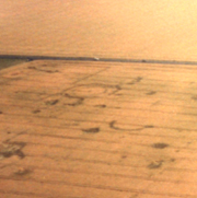
Cropmarks on one side of the valley along which runs Shottendane Road
Photographer unknown
* New research today (11.10.06) has uncovered the possible existence of another ring-ditch monument which was encountered during a watching brief at Brooksend Hill in 1990. This may not feature on the current cropmark list and should be included amongst the 'excavated' sites. This further offsets the inclusion of LOM VII as an excavated site, as far as the statistics are concerned at least.
It is important to note however that the
Thanet database actually lists a total of 56 excavated sites, with the
monument known as Monkton-Minster VIII A + B having two separate
entries, but I have included it here as a single, though multi-phase
monument for now (as is the triple ring-ditch Lord of the Manor I, for
example).
The number of excavated sites also includes one barrow which KARU is known to have excavated at Millmead, Margate, but it is possible that they may also have uncovered others. This is offset somewhat by the inclusion of Lord of the Manor VII in the same list, as it has now become uncertain as to whether this monument has actually been investigated through excavation. *
Also included in the excavated class are monuments that have been exposed or only partly exposed through excavation but have not necessarily been explored. This is particularly in respect of Bradstow School III, which was a short section of curving ditch (likely to represent a ring-ditch monument) exposed during a British Museum excavation centered upon Hurd's original barrow find at Valetta House (Bradstow School I). It is not known whether this ditch was actually sampled though.
Latest research:
the results!
(Updated 21.10.06)
Unexcavated sites: 425
Excavated sites: 55*
Known total: 480
Thanet's area: 86.31 sq km
Urban areas: 33.64 sq km**
Cropmark area: 52.67 sq km
Sites per sq km: 9.11
Lost to ploughing?: 0 / 120 ***
Sites p sq km: 9.11 / 11.39***
Land erosion: 25.2 sq km
Monuments lost?: 229 / 287***
Possible total?: 709 / 887***
* The new Thanet database list has separated the Monkton-Minster VIII A+B
monuments into two sites but has been counted here as one.
** This does include two small areas within the urban area calculation which had been surveyed through aerial photography prior to later development and thus has presented us with cropmark data.
*** Including the 'Cunliffe Variable' of his estimate that 25% of the monuments will have been destroyed.
Work by Oliver Gardner (using a
digitised map of Thanet) has estimated
that today the remnant of the Isle which lies within its ancient
coast-line comprises an area of around 86.31 square kilometres (sq
km). He has also estimated that Thanet's urban and village areas
(calculated using a map from 1970s and therefore now a minimum
estimate) cover a total of 33.641 sq km; (this figure includes the
developed areas of Manston Airport, estimated at 2.719 sq km).
It should be noted however that this figure does also take in two small urban areas which had previously been surveyed through aerial photography (the Sunley Estate at Cliftonville and around Newington, Ramsgate) and thus have given us cropmark data.
We are now in a position to provide the best ever estimate of ring-ditch/barrow monument density on the Isle of Thanet - an impressive 9.11 per sq km.
One must not forget of course that this is a broad figure which gives the density of such monuments as they appear across the landscape of the Isle as a whole. The next step is to explore where these monuments occur with regards to favoured geographical or geological locations. This will give us a better idea of their density in areas where they were purposely sited and permit more accurate predictions of locations where others may be expected to be found and the numbers in which they might be found there. It will also allow an estimate of those which now lie buried under areas of development. (This work is in progress - check back for further updates soon).
The figure of 480 is only the visible part of the story of course. There is also more to consider, for Thanet may have lost approximately 25.2 sq km of its coastline since the Bronze Age (Perkins 1987). This suggests that 229 (actually 229.572) ring-ditch monuments could have been lost to coastal erosion. This makes a potential total of 709 monuments which might have originally existed on the Isle.
In Dr. Perkins' (1999) work he noted
that in Professor Cunliffe's study of Wessex barrows (1993) the
author had
suggested that
25% will have been destroyed without trace. Thanet's long history of
arable farming suggests that an equal percentage of barrows could have
been destroyed by similar farming methods. If such a figure is applied
to Thanet's known roundbarrow total of 480 it suggests another 120
could potentially
have existed.
Photographer unknown
Combining the figures of Thanet's known
total (480) and those
potentially destroyed by agricultural processes etc (Cunliffe estimates
25% - therefore 120 Thanet monuments) gives a figure of 600. This
gives
a 'Sites per sq km' figure of 11.39, which would alter the estimate of
those
lost to coastal erosion to 287 (actually 287.028).
Combining the numbers of known
barrows/ring-ditch monuments
and those estimated to have been
subsequently destroyed by coastal erosion alone (excluding the
'Cunliffe Variable') gives a possible total for Thanet's
roundbarrows at 709. If one includes the destruction factor estimated
by the 'Cunliffe Variable' as 25%, then the potential total rises to
887.
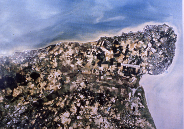
of the Isle of Thanet
Copyright unknown
Note the extent of the urban areas
The convenient, grey-coloured scale in the right of the picture is actually the runway at Manston Airport, which is approximately 2.77km long
Here I would like to acknowledge the
efforts of all of those people who have contributed to the study of the
ring-ditch and roundbarrow monuments of the Isle of Thanet.
In particular sincere thanks go to Susan
Deacon (for digitising the plan of Perkin's 1999 work and also for her
work on the digital mapping of Thanet sites in general, including all
the RCHME maps and for her work in rectifying aerial photographs); Pip
Fisk (for her gazetteer of excavated ring-ditch and roundbarrow sites
on Thanet); Oliver Gardner (for the compilation, review and refinement
of all the data on ring-ditch and roundbarrow monuments on Thanet, plus
the establishment of the individual maps and the database); Ges Moody
(for the inception of the digital review and the ideas of
what can be achieved with it), Nigel Macpherson Grant and Dr. Dave
Perkins (for their excavations and analysese of many of the ring-ditch
sites).
Thanks go to John Smythe who provided
the Trust for Thanet Archaeology with a new copy of the list of the
RCHME ring-ditch data for Thanet. Thanks also go to the
photographers and
personnel of the RCHME who established the initial survey which formed
the base for this ongoing study.
Paul
Hart
Version 1 - Posted 10.08.06
Version 2 - Posted 21.10.06
Version 1 - Posted 10.08.06
Version 2 - Posted 21.10.06
All
content © Trust for Thanet Archaeology