Return to Roundbarrows Display
Display Contents
Ring-ditches and roundbarrows of Thanet - Section 4
Section 1
Introduction
The numbers game
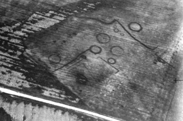
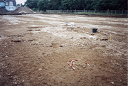
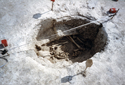
Cropmarks at Crispe Farm
Photographer unknown
Characterising the distribution
Section 3
A new review
New discoveries/old
Coastal erosion
An estimated total
Section 4
Position
Population
Observations
Section 5
Causewayed ditches
Dating
Significance
Thanet's barrows cluster above the sea
shore or on valleys leading to the
sea. If the number and position of the barrows reflects the
distribution of the Bronze Age population, it could indicate fairly
concentrated settlement in the fertile
deep-soil valleys below the cemeteries (why the remains are seldom
encountered
today perhaps), or on the colluvial slopes
between downland and shore (Perkins 1999).
The siting of many barrows on the
relatively thin soils of chalk upland pasture could suggest
deliberate positioning away from the more fertile valley soils which
were better suited to cultivation (Perkins 1999).
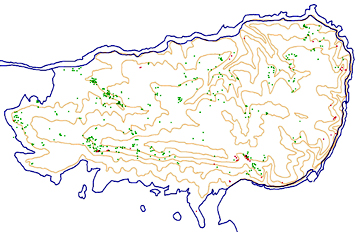
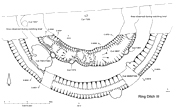
The creation of a new digital map of the ring-ditch and roundbarrow monuments on the Isle of Thanet (recently completed and revealed below) now allows us to present the clearest view yet of their precise topographical contexts.
This helps us to further understand some of the geographical factors which may have influenced their positioning and importantly these ideas can also suggest locations where we may expect them to have been constructed but where they have not yet been discovered, largely due to areas of pre-existing urban development (Ges Moody pers comm.).
on the Isle of Thanet (as of 01.12.06)
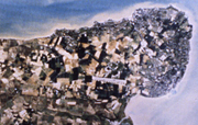
The Isle of Thanet
showing areas of development
(copyright unknown)
Key to map:
Cropmark sites
Excavated sites
Contours (10 metre intervals)
The burials found in Thanet's Earlier
Bronze Age roundbarrows and
flat-graves likely represent only a fraction of the total contemporary
population.
Dr. Perkins suggested (1999) that an estimate based on burials alone
indicates a living 'barrow-rite'
population of only 30 persons. As he pointed out, this is
'an
absurd proposition, as it would not have a labour force big enough to
bury its dead'!
He suggested that these burials
represent a social
'Elite' (or a selected part of a wider community). The
burial practices which were employed by the bulk of the
community can only be guessed at as no evidence has been found of any
other sufficiently common burial rite.
Of course any estimate of population
density
during the Early Bronze Age is difficult. Dr. Perkins has suggested
that it could have
numbered from approximately 2400 - 6000 individuals. This is dependant
upon whether the burial 'Elite' represent approximately 5% or only 2%
of the population (Perkins 1999).
Today the Isle of Thanet's population
numbers
over 100,000 people (I believe).
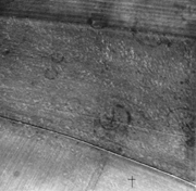
Cropmarks at Brooksend Hill, Great Brooksend Farm
Photographer unknown
Sample size
At least 55 ring-ditch and roundbarrow monuments are known to have been excavated or exposed through excavations on the Isle of Thanet.
This figure includes only one roundbarrow known to have been excavated at Millmead, Margate by KARU in the 1970s (of which no details are known at present), but they may have also excavated others. The figure also includes the potential Causewayed ring-ditch monument IV from the Monkton-Minster A253 excavations (Fisk 2003), of which only a small part was exposed and which might not be a ring-ditch monument at all.
Another inclusion which might be in error is the site of Lord of the Manor VII. A little confusion surrounded the traditional numbering of some of the Lord of the Manor monuments and it may be that this site was not actually excavated (investigation underway). Its inclusion at present is offset (statistically) by the discovery (at the time of writing this current update - 11.10.06) of a possible ring-ditch monument encountered during a watching brief at Brooksend Hill in 1990. This may not already feature on the new Thanet 'unexcavated cropmark' database at present and could count as an additional site (investigation also underway).
The uncertainty over one or two ring-ditches/ roundbarrows aside, this proportion of excavated monuments provides us with a large sample and a great body of data that has revealed much variability in the form and periods of use of these monuments (research continues!).
Individuality and agency
While the ring-ditched burial monuments might all have been based around an archetype embedded in the culture of our Late Neolithic and Bronze Age ancestors, they would have all been created by individuals which is probably the cause of the variations and originality that arise.
This is an important factor which needs to be considered when attempting to understand the monuments and trace their history. Comparisons may be drawn and types defined but these should not be applied too readily, for this may be at the expense of a chance to understand the monuments and the motivation of the individual acts involved in their creation.
Bon Secours' 4m Deverel-Rimbury barrow showing faintly as a flint-filled ditch
An associated cremation burial is surrounded by scales in the foreground
Scales in 0.1 metre divisions
(the other of the two 4m monuments was found at Ebbsfleet)
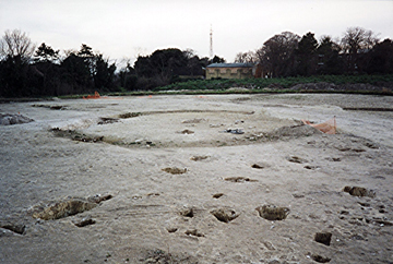
The largest ring-ditch monument yet excavated on Thanet:
Monkton-Minster A253's 35m
double ring-ditch monument III
Plan from Fisk (2003)
Copyright Canterbury Archaeological Trust
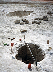
Much variation exists in the size of the excavated ring-ditch and roundbarrow monuments and in the degree of care taken during their construction. Diameters range from 4m to 35m; surface ditch widths vary from 0.30m to 5.5m (possibly 6.90m); base ditch widths vary from 0.20m to 2.22m; ditch depths range from 0.19m to 1.72m (possibly 1.80m).
The ditch-form is often that of a truncated (ie. cut-off and flat-bottomed) 'V'-shape, with very steeply-sloping sides and a flat base. Some may feature internal or external ledges near the surface and sometimes the initial cut into the top of the chalk may be much more gently sloping and shallow.
Many ditches also show evidence of re-cutting, where the soil infill accumulated over a substantial period of time has been cleared out in part; perhaps to increase the amount of mound material in advance of the insertion of additional cremation burials, or to create a new central mound inside a monument which didn't originally have one .
This activity may also reflect the renovation and re-use of much earlier monuments. Some of the roundbarrows discovered at Lord of the Manor (LOM), Ramsgate showed several phases of use, with ditches being re-excavated or new ditches cut creating double and triple ring-ditch cropmarks.
The multi-phase ring-ditches of LOM I showed some Beaker Period renovation of an earlier monument along with subsequent Early Bronze Age modifications and burials. The large, single ring-ditch LOM III has a re-cut ditch and a narrowed causeway associated with its re-use as a place for the interment of a Collared Urn cremation in the Early Bronze Age.
North Foreland II
discovered at the former St. Stephen's College site at North Foreland, Broadstairs
North Foreland
The central burial is in the background
It
appears that central inhumation
burials always feature rectangular-shaped grave cuts, while the
subsidiary outer burials
are frequently within oval or more rounded grave-pits.
The rectangular central grave
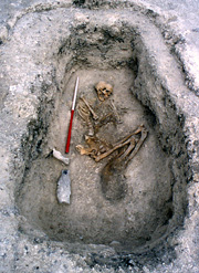
Scale in 0.5 metre divisions
Photo by TTA/CAT
The oval outer grave
Associated
burials
Overall there has been at least 56 burials recorded from within these monuments and their ditches (this figure is under active review - check back soon). However this number solely represents the recovery of skeletal material (including ashes) and does not include external burials or the 'several' found at Hackemdown Banks. It also does not include 'empty graves' thought likely (but not certainly) to have contained burials.
A study of the position and orientation of the burials has not yet been completed but one suspects a great deal of variation is present.
Grave forms
One potentially important trend emerged during a compilation of the plans for Thanet's Causewayed ring-ditches (presented elsewhere in these pages). It appears that central inhumation burials always feature rectangular-shaped grave cuts, while the outer burials are frequently within oval or more rounded grave-pits. Where the subsidiary graves are also rectangular they tend to be rounded/sub-rectangular, featuring very rounded ends. This trend appears to be universal in Thanet's roundbarrow monuments, with only two minor exceptions.
One exception is the somewhat unique Beaker barrow (including a Food Vessel) from South Dumpton Down. This monument features several intercutting grave-pits, most of which are rounded. However one was rectangular (though with rounded ends) and this one appears to be associated with the first phase of burial at the site (and thus agreeing with the observed trend).
The second minor exception comes from the final phase (Phase 4) of activity at Lord of the Manor I. Five inhumation graves and one cremation were associated with this phase. One of the inhumation burials (Grave 2) is in a well defined rectangular pit, the rest are either oval or rounded-rectangular in shape. These are set within a ring-ditch which surrounds a rectangular central burial, all of which were constructed during the preceding Phase 3.
As the Phase 3 and 4 burials are from two separate episodes of activity at Lord of the Manor I this again does not actually contradict the observed trend. Perhaps the distinctly rectangular grave (G.2) from Phase 4 was the first to have been dug during that later series of interments?
Could it be that there was a regular tradition of interring the primary burial within a roundbarrow (and perhaps the first burial of any later but related burial phase) in a rectangular grave, while subsequent burials were interred within oval and more rounded (including rounded-rectangular) grave-cuts? This appears to be the case at the moment.
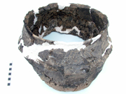
A Collared Urn
from Lord of the Manor
Six of Thanet's 56 ring-ditch and roundbarrow burials are cremations. However a broken Collared Urn discovered during Hurd's Valletta House excavations of 1911 (now known as Bradstow School I) did not contain any cremated human remains and has not been counted here as a burial (but may well represent one). Likewise an atypical Middle Bronze Age Urn from a double ring-ditched monument also discovered by Hurd at King Edward Avenue, Broadstairs is not certainly known to have contained a cremation at present.
Burial-less monuments
At least 32 monuments have failed to produce any certain evidence of burials, though at least 8 of these can be thought of as likely barrows containing graves who's human remains have eroded away.
This leaves 24 monuments (43.63%) which offer no certain evidence of having a burial phase; though this figure includes some monuments which have only seen partial excavation and a very few which have only been part-exposed and not excavated.
At least 8 of the 24 burial-less monuments had no evidence of internal features of any kind. Whether these monuments represent barrow mounds constructed to take cremation burials (or other forms of surface inhumation) or had another function entirely will probably have to remain as speculation.
Of particular interest in this regard are the group of 10 ring-ditch monuments discovered along the Monkton-Minster A253. Eight of these contained no burials at all (Monkton-Minster I-VIII; though VII and VIII were thought to be asociated with Middle Bronze Age cremations and it was felt that V may once have had burials; Fisk 2003). The two remaining monuments (IX and X) both featured single Deverel Rimbury (Middle Bronze Age) cremations (Fisk 2003).
Other features
Some monuments show internal pits and post-holes, while others are entirely featureless. Perhaps one may guess that these latter types had been created to raise a central mound for receiving cremation burials (and on this basis perhaps date no earlier than circa 2000 BC). However one must not forget the factor of 'individuals' working within a tradition of course.
We should also be careful of too readily applying the title of 'roundbarrow' to a burial-less ring-ditch monument, lest we preclude other interpretations!
In addition to the efforts of all who
have contributed to the production of the new digital map of the
ring-ditch and roundbarrow monuments of Thanet (acknowledged elsewhere)
I should like to thank Ges Moody for the picture of the aforementioned
digital map presented above.
Paul
Hart
Version 1 - Posted 10.08.06
Version 2 - Posted 21.10.06
Version 3 - Posted 16.12.06
Version 1 - Posted 10.08.06
Version 2 - Posted 21.10.06
Version 3 - Posted 16.12.06
All
content © Trust for Thanet Archaeology