Ring-ditches and roundbarrows of Thanet - Section 5
Display Contents
Ring-ditches and roundbarrows of Thanet - Section 5
Link -
A Gazetteer of Causewayed ring-ditches and roundbarrows excavated on Thanet
? Late Neolithic
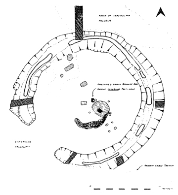
Mill Lane Margate
Lord of the Manor IID
Lord of the Manor III
Beaker Period
Chalk Hill
Link -
A Gazetteer of Causewayed ring-ditches and roundbarrows excavated on Thanet
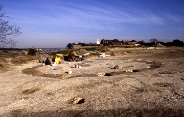
The Causewayed roundbarrow at North Foreland, Broadstairs
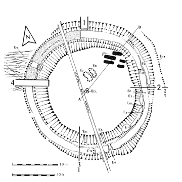
Lord of the Manor I
Hartsdown I
? Middle Bronze Age
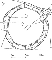
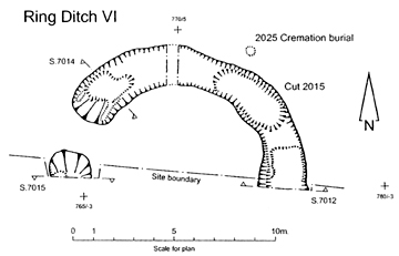
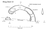
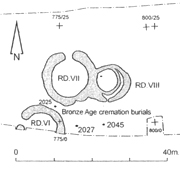
Monkton-Minster VI
Monkton Minster VII
Monkton-Minster VIII B
Date uncertain
Lord of the Manor V
North Foreland III
Bradstow School IV
Some data on the Causewayed ring-ditch monuments excavated on Thanet is presented below [map forthcoming].
Several of these barrows exhibit different phases of use, including the re-use and refurbishment of earlier monuments. As such they have been ordered according to the likely date associated with the construction of the causewayed ditch.
Several of these barrows exhibit different phases of use, including the re-use and refurbishment of earlier monuments. As such they have been ordered according to the likely date associated with the construction of the causewayed ditch.
Each entry contains a
brief
description of these often complicated monuments. Any burials
described were located in the area enclosed within the ring-ditch
unless otherwise indicated.
Information on all but the latest discoveries has been taken from the gazetteer compiled by Mrs P. Fisk in 2003. Mr. John Villette provided information on the monument at Mill Lane, Margate.
Some of the entries are linked to pages which give more detailed information (and pictures) on each site. See also the Henges Display in the Neolithic Gallery. It is hoped to extend these displays (and their links) in the future.
Outer ditch
Diameter: ?
Width top: ?
Width base: ?
Depth: ?
Recut: ?
Inner ditch
Diameter: ?
Width top: ?
Width base: ?
Depth: ?
Recut: Yes
Causeways: 1 (Outer ditch)
Causeway orientation: ?
Causeway width: ?
Causeway slighted: ?
Orientation: ?
Height: ?
Rescue Excavation instigated and
conducted by John Villette, assisted by the Kent Archaeological Rescue
Unit.
Part of a Causewayed ring-ditch
monument seems to have been encountered during the construction of the
Multi-Storey Car Park in Margate. Overall the monument comprised
two ditches, with the outer one having a causeway. The inner ditch
(possibly shallow) had apparently been backfilled with chalk and
subsequently re-cut. At the centre of the monument were 'radiating
slots' (not deep) which may have represented the base of a Post-Mill.
A grave containing a crouched inhumation
burial was found cut into the surface
of the causeway. The grave also produced finger-tip decorated pottery
which may have been Mid/Late Neolithic Peterborough Ware.
Similar sherds of an 'incomplete pot' of apparent Peterborough Ware were also found in the fill of the terminus of the outer ditch (at the point of the causeway, by the burial).
On current evidence this monument could have been a Late Neolithic Henge. The grave could represent either a foundation deposit or perhaps a blocking deposit.
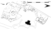
NGR 635435 170622.
John Villette pers comm.
Mynot 1975.
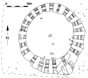
Diameter: 22.0-23.0m.
Width top: 2.0-4.0m.
Width base: 0.3-2.0m.
Depth: 1.20-1.60m.
Recut: No
Causeways: 1
Causeway orientation: SW
Causeway width: 5.80m.
Causeway slighted: No
Orientation: SW facing slope
Height: 39m OD.

(TAU)
Excavation led by Nigel Macpherson
Grant and David Perkins, Thanet Archaeological Unit; (LOM IID).
A single ring-ditch monument with a causeway in the south-west and slots cut into the base of the ditch (possibly constructed in the Late Neolithic). Within the enclosure were the hollows, pits, a platform of rammed chalk, a semi-circular flint bank, a hearth, occupation debris including Beaker pottery and the post-holes of a pentagonal structure with an entrance corridor (associated with the chalk platform and flint bank).
A later central crouched inhumation burial covers one of the post-holes and may be associated with a renewal of the post-hole structure.
NGR 635463 165370.
Fisk 2003; Macpherson Grant 1981.
Diameter: 30.0m.
Width top: 3.0-5.5m.
Width base: 1.0-2.0m.
Depth: 1.70m
(max 1.56m below chalk ?)
(max 1.85m.+ topsoil)
Recut: Yes
Causeways: 1
Causeway orientation: S
Causeway width: 4.0m / 0.6m.
Causeway slighted: Yes
Orientation: SW facing slope
Height: 39m OD.

(TAU)

(TAU)
Excavation led by Nigel Macpherson Grant
and David Perkins, Thanet Archaeological Unit; (LOM III).
A single ring-ditch monument with a causeway to the south. The causeway was subsequently narrowed from 4.0m to 0.6m, probably an act of closure when the original monument was abandoned.
The infilled ditch was recut (intermittently, internally and externally), possibly to proved material for a central mound which covered a central cremation burial in an inverted Collared Urn (B2). Other cremations may have been placed within the mound, to be destroyed by later ploughing.
The skull of small-headed female (about 12-15 years old and possibly a dwarf) was found on the base of the ditch to the east. The skull had a boar’s rib placed through the foramen magnum at the back of her head (Macpherson Grant). It is not certain at present whether this act of ritual deposition is related to the original or later Early Bronze Age phase of use of the monument (but seems likely to have been the former).
Later Anglo-Saxon burials cut into the edge of the mound to the north-west and disturbed one of the internal Prehistoric pits (F1).
NGR 635525 165288.
Fisk 2003.
Diameter: 12.0m.
Width top: ?
Width base: ?
Depth: ?
Recut: ?
Causeways: 1
Causeway orientation: WSW
Causeway width: ? (1.30m?)
Causeway slighted: Possibly
Orientation: SE facing slope
Height: 32m OD.

Copyright Canterbury Archaeological Trust
Copyright Canterbury Archaeological Trust
Excavated by Canterbury Archaeological
Trust.
A small single ring-ditch with a sunken causeway to the south-west. Contained a central Beaker crouched inhumation burial and at least one other grave, plus a pit to the west.
The second burial featured the remains of both a human and a bovine juvenile.
The barrow may have been without a central mound. More information will be known when the final report is published.
NGR 636190
164444.A small single ring-ditch with a sunken causeway to the south-west. Contained a central Beaker crouched inhumation burial and at least one other grave, plus a pit to the west.
The second burial featured the remains of both a human and a bovine juvenile.
The barrow may have been without a central mound. More information will be known when the final report is published.
Fisk 2003; Shand 2002.
Outer ditch
Diameter: 30.0m.
Width top: 3.0m.
Width base: ?
Depth: 1.5m.
Recut: Yes
Inner ditch
Diameter: 12m.
Width top: 1.5m.
Width base: ?
Depth: 0.8m.
Recut: No
Middle ditch
Diameter: 19m.
Width top: 2.0m.
Width base: ?
Depth: 0.57-1.3m.
Recut: No
Causeways: 1 (Middle ditch)
Causeway orientation: SE
Causeway width: 8.5m.
Causeway slighted: Yes
Orientation: SW facing slope
Height: 41m OD.
(TAU)
Excavation led by Nigel
Macpherson Grant, Thanet Archaeological Unit; (LOM I).
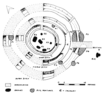
A four-phase triple
ring-ditch monument.
The large outer ditch was dug
first (Phase 1; likely during the Later Neolithic) and the subsequent
infill was
later re-cut during the Beaker
Period (Phase 2) circa
1950-1850 BC.
Pit F1 was also dug. A burial outside the ditch (1A) may belong to
either phase.
The re-cut outer ditch began to
infill again and then the inner ditch was dug (Phase 3), along
with central Burial 5 (no clearly dateable finds, but possibly circa
1800-1750 BC).
(TAU)
Once the inner ditch
became
half-infilled the middle ditch was dug (Phase 4) with
a causeway to the south-east. Six burials comprising one cremation
(Burial 6, with a barbed and tanged arrowhead) and five crouched
inhumations (Burials 1-4 and 7) were deposited. This phase possibly
occurred circa 1700-1500 BC.
Finally the causeway was 'blocked' by the digging of a trench
across it.
Disarticulated human bone was recovered
from both the lower and upper
fills of all three ditches with the exception of the upper fill of the
final,
Middle ditch. Carved chalk objects were recovered from the primary
silts of the Inner ditch (a 'cup/lamp'), the Middle ditch (a
'cup/lamp' and two blocks with criss-cross carvings) and the Outer
ditch (a 'cup/lamp').
NGR 635507 165430.
Fisk 2003. Macpherson Grant 1977.
Click here to link to a Display with some more information and pictures on this site.
Outer ditch
Diameter: 22.0m.
Width top: 1.7m.
Width base: 1.2m.
Depth: 0.5m.
Recut: No
Inner ditch
Diameter: 14m.
Width top: ?
Width base: ?
Depth: 0.6m.
Recut: No
Causeways: 1 (Outer ditch)
Causeway orientation: NNE
Causeway width: 2.4m.
Causeway slighted: No ?
Orientation: SE facing slope
Height: 17m OD.
(TTA)
Excavation led by David Perkins, Trust
for Thanet Archaeology; (HCW95).
This monument was sampled by four evaluation trenches and appeared to comprise an oval ring-ditch with a causeway to the north and a second, internal, half-circular ditch. Part-revealed in the centre was an apparently irregular-shaped pit with steeply sloping sides which was excavated but found to be 'too deep to bottom'. Interpreted as a possible flint mine entrance.
A lack of chalk in the ditch-fills suggests that perhaps this monument never had a mound. It could well be something other than a roundbarrow, or a ring-ditch monument that never had a roundbarrow phase. Possibly Early Bronze Age ?
NGR 634875 169845.
Fisk 2003.
Diameter: 12.70m.
Width top: 2.25m.
Width base: 1.2-1.4m.
Depth: 0.2-0.4m.
Recut: No
Causeways: 1
Causeway orientation: NW
Causeway width: 1.7m.
Causeway slighted: No
Orientation: S facing slope
Height: 29m OD.
Copyright Canterbury Archaeological trust
Copyright Canterbury Archaeological Trust
Excavated by Canterbury Archaeological
Trust.
A single ring-ditch monument with a causeway (1.7m wide) at the north-west. The ditch was cut irregularly in three places. No internal features. Possible evidence for a central mound.
Over 60 sherds of Middle Bronze Age Deverel Rimbury pottery were recovered from restricted segments of the ditch to the north-east.
NGR 629349 165638.
Fisk 2003.
Diameter: 14.60m.
Width top: 2.1-2.5m.
Width base: 0.3-0.4m.
Depth: 1.0-1.5m.
Recut: No
Causeways: 2
Causeway 1 orientation: N
Causeway 2 orientation: SSE
N Causeway width: 2.0m.
S Causeway width: 0.9m.
N Causeway slighted: No
S Causeway slighted: Yes
Orientation: S facing slope
Height: 32m OD.

Copyright Canterbury Archaeological Trust
Copyright Canterbury Archaeological Trust
Excavated
by Canterbury Archaeological
Trust.
The complex, interconnecting ring-ditch monuments VII and VIII (see below) were created in five different phases. Ring-ditch VII forms Phase Three in this sequence.
A single ring-ditch monument with two causeways to the north (2m wide) and south (0.9m wide). The southern causeway was later 'blocked' by a shallow cut (Phase Five). No internal features.
The ditch contained some Early Bronze Age pottery, plus some redeposited Deverel Rimbury sherds (in the upper fill of the western ditch).
Three Middle Bronze Age (presumably Deverel Rimbury) cremation burials are thought to be associated with ring-ditches VII and VIII.
NGR 629356 165653.
Fisk 2003.
Click here to link to a Display with some more information on this site.
Diameter: 9.40m.
Width top: 1.0m.
Width base: 0.2-0.4m.
Depth: 0.3-0.5m.
Recut: Yes
Causeways: 1
Causeway orientation: S
Causeway width Phase 4: 2.3m.
Causeway slighted: No
Orientation: S facing slope
Height: 31m OD.
Copyright Canterbury Archaeological Trust
Copyright Canterbury Archaeological Trust

Excavated by
Canterbury Archaeological
Trust.
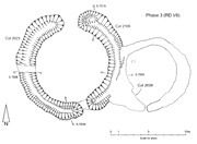
The interconnecting ring-ditch monuments VII and VIII (see above) were created in five different phases. Ring-ditch VIIIB is a re-cut comprising a refurbishment and enlargement of un-causewayed single ring-ditch monument VIIIA which was created in Phase One (undated). VIIIB is slightly offset to the south-east and was formed in a complex sequence across Phases 2 and 4 plus a re-cut in Phase 5 (which also saw the 'blocking' of ring-ditch VII's causeway). The causeway faces south.
The interconnecting ring-ditch monuments VII and VIII (see above) were created in five different phases. Ring-ditch VIIIB is a re-cut comprising a refurbishment and enlargement of un-causewayed single ring-ditch monument VIIIA which was created in Phase One (undated). VIIIB is slightly offset to the south-east and was formed in a complex sequence across Phases 2 and 4 plus a re-cut in Phase 5 (which also saw the 'blocking' of ring-ditch VII's causeway). The causeway faces south.
The offsetting of VIIIB over VIIIA may
suggest that the ring-ditch of VIIIA may have entirely infilled and not
been apparent when the re-cut occurred. Perhaps only the mound existed
as a visible earthwork.
No apparently significant internal features were present; one small pit (?) is visible on the plan.
No apparently significant internal features were present; one small pit (?) is visible on the plan.
NGR 629366 165652.
Fisk 2003.
Click here to link to a Display with some more information on this site.
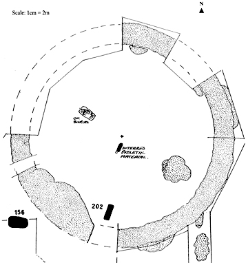
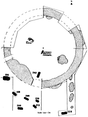
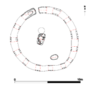
Diameter: 32.5m.
Width top: 3.0m.
Width base: 1.0m.
Depth: 1.6m.
Recut: Yes
Causeways: 1 possible
Causeway orientation: (?) NW
Causeway width: ?
Causeway slighted: ?
Orientation: SW facing slope
Height: 40m OD.
(TAU)
Excavation led by David Perkins, Thanet
Archaeological Unit; (LOM V).
A single ring-ditch monument, possibly with a causeway in the unexcavated portion of the ditch. Two similar monuments nearby have a causeway in alignment with this unexcavated portion. Aerial photographs also suggest the presence of a causeway.
The circular enclosure was constructed and abandoned, then latterly re-used. The infilled ditch was re-excavated (a recut spaced alternately on the inside and outside), possibly to provide material for a central mound. Slots were also cut into the base of the ditch.
A central 'ossuary' pit was dug and filled with the selected remains of five individuals. The angle of the pit suggests that a mound may have been present. To the west was the burial of an ox, orientated at right angles to the central burial.
Later Anglo-Saxon burials were also
present to the south and south-west.
NGR 635601 165292.
Fisk 2003.
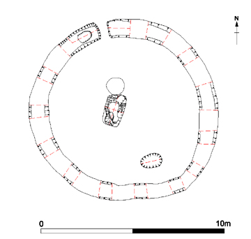
Diameter: 10.0m-10.50m.
Width top: 0.78-1.03m.
Width base: 0.57-0.81m.
Depth: 0.36-0.53m.
Recut: No
Causeways: 1
Causeway orientation: NNE
Causeway width: 0.40m
Causeway slighted: No
Orientation: NW facing ridge
Height: 40m OD.
The Causewayed barrow is to the left of the scale.
(TTA)
Excavation led by David
Perkins,
Trust for Thanet Archaeology and Mike Diack, Canterbury Archaeological
Trust; latterly concluded by the Trust for Thanet Archaeology; (NFB99).
A single ring-ditch monument
with a narrow causeway (0.40m wide) to the
north.
Within the roundbarrow were two graves (one central, one to the
south-east) and a pit plus some other small and shallows pits and
post-holes. A third grave was cut into the bottom of
the ditch to the west of the causeway.
Both internal graves
were
shallow and poorly preserved. The rectangular central burial held the
remains of an adult, laid on their left-hand side with the head to the
south, facing west. The individual may have been laid within a
coffin-structure. To the south-east of the first grave lay the even
more poorly preserved
burial of an individual laid within an oval grave.
Immediately to the west of the central burial was a round pit which had been filled with small nodules of burnt flint and capped by large slabs of tabular flint and sandstone (possibly non-local Greensand/Ragstone). This feature seems to represent an act of purposeful deposition and could have been connected with rituals associated the central burial or the founding of the monument.
Immediately to the west of the central burial was a round pit which had been filled with small nodules of burnt flint and capped by large slabs of tabular flint and sandstone (possibly non-local Greensand/Ragstone). This feature seems to represent an act of purposeful deposition and could have been connected with rituals associated the central burial or the founding of the monument.
Cut into the bottom of the
ditch, close to the causeway, was the well preserved grave of a small
child. A large fragment of whale bone had been laid across the surface
of south-eastern side of the grave.
NGR 639700 169252.
Boast, Gardner and Moody 2006; Fisk 2003.
Click here to link to a Display with some more information and pictures on this site.
NGR 639700 169252.
Boast, Gardner and Moody 2006; Fisk 2003.
Click here to link to a Display with some more information and pictures on this site.
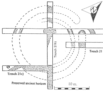
Diameter: 31.36-32.73m.
(possibly to 34.09m.)
Width top: 3.40-5.10m.
(possibly to 6.78m.)
Width base: 0.95-1.26m.
Depth: 1.50-1.72m.
(possibly 1.80m.)
Recut: No
Causeways: 1
Causeway orientation: WNW
Causeway width: 0.55m.
Causeway slighted: Probably
Orientation: SE facing slope
Height: 42m OD.

Copyright Archaeology South East
Copyright
Archaeology South East
Evaluation led by Ges Moody of the Trust
for Thanet Archaeology; (BSD06). Excavation led by Diccon Hart of
Archaeology
South East; (DPB06).
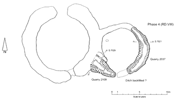
A large, single ring-ditch monument with
a small, narrow causeway (0.55m wide) to
the west. The diameter of the ring-ditch ranged from approximately
31.36m-32.73m (D.Hart 2006),
though in an area adjacent to some later quarry pits it reached a
maximum of 34.09m (having a broad, shallow outer edge beyond the steep
ditch-cut; one that may have resulted from the later pit-cutting
episode).
The surface of the causeway had been cut 0.55m below the level of the natural chalk. It would seem likely that the original causeway was 'slighted', being cut down and narrowed at its surface (leaving a rounded and somewhat precarious track into the centre of the monument) as an act of 'blocking/closure' once it went out of use. Evidence from the sections may be inconclusive in this regard.
The surface of the causeway had been cut 0.55m below the level of the natural chalk. It would seem likely that the original causeway was 'slighted', being cut down and narrowed at its surface (leaving a rounded and somewhat precarious track into the centre of the monument) as an act of 'blocking/closure' once it went out of use. Evidence from the sections may be inconclusive in this regard.
Copyright
Archaeology South East
Several relatively small and shallow
rectangular and oval pits were discovered in the interior; a
rectangular pit lay at the
centre. No burials or finds of
any significance were discovered.
Though this monument has been referred to as a 'large Bronze Age round barrow' (D.Hart 2006) and may have had a barrow phase (the burial evidence of which may be largely lost to us) there is also a possibility that it may have started life as a Late Neolithic ceremonial enclosure or Henge.
The large dimensions of this feature may add weight to such an interpretation. It is the largest single and largest Causewayed ring-ditch monument excavated so far on Thanet. Only the double ring-ditched Monkton-Minster III is larger (at 35m in diameter; Fisk 2003). The ditch-depth is likely the deepest yet recorded on Thanet, while the ditch-width may be second only to LOM III (and at its potential full extent is the largest). As a whole the monument is comparable to LOM III, which was likely founded in the Late Neolithic.
The Bradstow monument may also have provided a focus for the three certain (and possibly four) roundbarrows which were constructed to the north and north-east.
The information presented
here will be reviewed and updated when a report on the excavations is
published by ASE. This will
also permit the posting of a page giving a more detailed review (with
many photographs) on this interesting site.
NGR 639399 167038.
The dimensions of the ditch are derived from measurements taken by Paul Hart during ASE's excavation. This was done with the kind permission of Diccon Hart. The maximum diameter of the monument has been measured from a site plan published in the KAS Newsletter (D. Hart 2006).
The dimensions of the ditch are derived from measurements taken by Paul Hart during ASE's excavation. This was done with the kind permission of Diccon Hart. The maximum diameter of the monument has been measured from a site plan published in the KAS Newsletter (D. Hart 2006).
Plan - D.Hart 2006.
ASE - Archaeology South East.
TAU - Thanet Archaeological Unit.
TTA - Trust for Thanet Archaeology.
Boast E.J., Gardner O.W. and Moody G.A. 2006. Excavations at St. Stephen's College, North Foreland, Broadstairs, Kent. Issue 1. Trust for Thanet Archaeology report.
Fisk P.M. 2003. An examination of the excavated ring ditch enclosures on The Isle of Thanet. Unpublished Degree thesis.
Hart D. 2006. Excavations at Bradstow School, Broadstairs. Kent Archaeological society Newsletter no. 69, 14-15.
Macpherson Grant N. 1977. Excavation of a Neolithic/Bronze Age Site
at Lord of the Manor, Haine Road, Ramsgate. Isle of Thanet
Archaeological Unit, Publication No. 1.
Macpherson Grant N. 1981. Lord of the
Manor Site 2, Site IID. Interim
Excavation Reports 1977-1980, 7-11. The Isle of Thanet
Archaeological Unit.
Mynot E. 1975. Kent Archaeological Review no.39, 254.
Shand G. 2002. Excavation at Chalk Hill, near Ramsgate 1997-98. CAT, Integrated assessment and updated research design report.

(Fisk 2006)
Particular thanks goes to Pip
Fisk for her work on compiling a thorough,
comprehensive and
invaluable
gazetteer on
the ring-ditch and roundbarrow monuments excavated on Thanet
(Fisk 2003).
Great effort was made by her to
gather as much published
and unpublished information
as possible and her
work has been (and continues to be) the 'one-stop-shop' for
research into these matters. The time which has been saved by
consulting this document is immeasureable and it has had a
profound impact on the labour taken to make the observations and
presentations of the ring-ditch
phenomena published here.
Version 1 - Posted 10.08.06
Version 2 - Posted 21.10.06
Version 3 - Posted 16.12.06
All
content © Trust for Thanet Archaeology