Return to Causewayed ring-ditches and roundbarrows excavated on Thanet
Display Contents
Causewayed ring-ditches and roundbarrows excavated on Thanet
Link -
North Foreland III
The Causewayed barrow
The internal burials
The flint pit
The ditch burial
Investigations at the site of the former
St. Stephen's College (NFB99) uncovered a wealth of archaeological
remains aside from the Causewayed roundbarrow. These included a much
larger Bronze Age roundbarrow (North Foreland II) and a third
(apparently burial-less)
ring-ditch monument (North Foreland I) which had been bisected by a
wall.
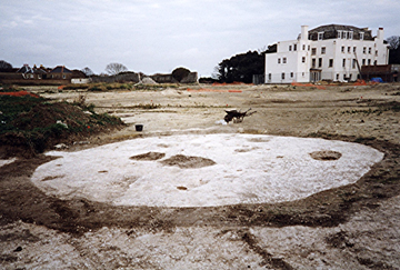
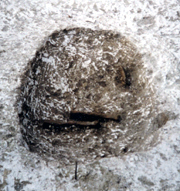
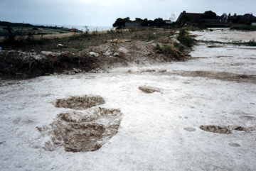
The Causewayed roundbarrow as first exposed
The central features ready for excavation (photo by TTA)
Near scale in 0.1 metre divisions
Far scale in 0.5 metre divisions
The bulk of the archaeological features
were the result of settlement
activity conducted at this
hill-top location throughout the Iron
Age. Evidence of their pits (including large grain storage pits) and
post-holes (representing wooden structures and fence-lines) were
widespread. There was also a rectangular enclosure and a substantial
boundary ditch which skirted around the small Causewayed roundbarrow.
Small fragments of Iron Age pottery were recovered from the Causewayed barrows' ring-ditch, shallow central burial and flint pit (see below) and reasoned to be an intrusive 'contamination' of this substantially earlier monument.
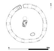
Plan of the NFB99 excavations (TTA)
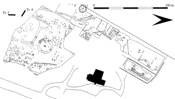
The Causewayed roundbarrow is directly to the left of the scale
Small fragments of Iron Age pottery were recovered from the Causewayed barrows' ring-ditch, shallow central burial and flint pit (see below) and reasoned to be an intrusive 'contamination' of this substantially earlier monument.
Plan of the NFB99 excavations (TTA)
The Causewayed roundbarrow is directly to the left of the scale
Section through the ring-ditch
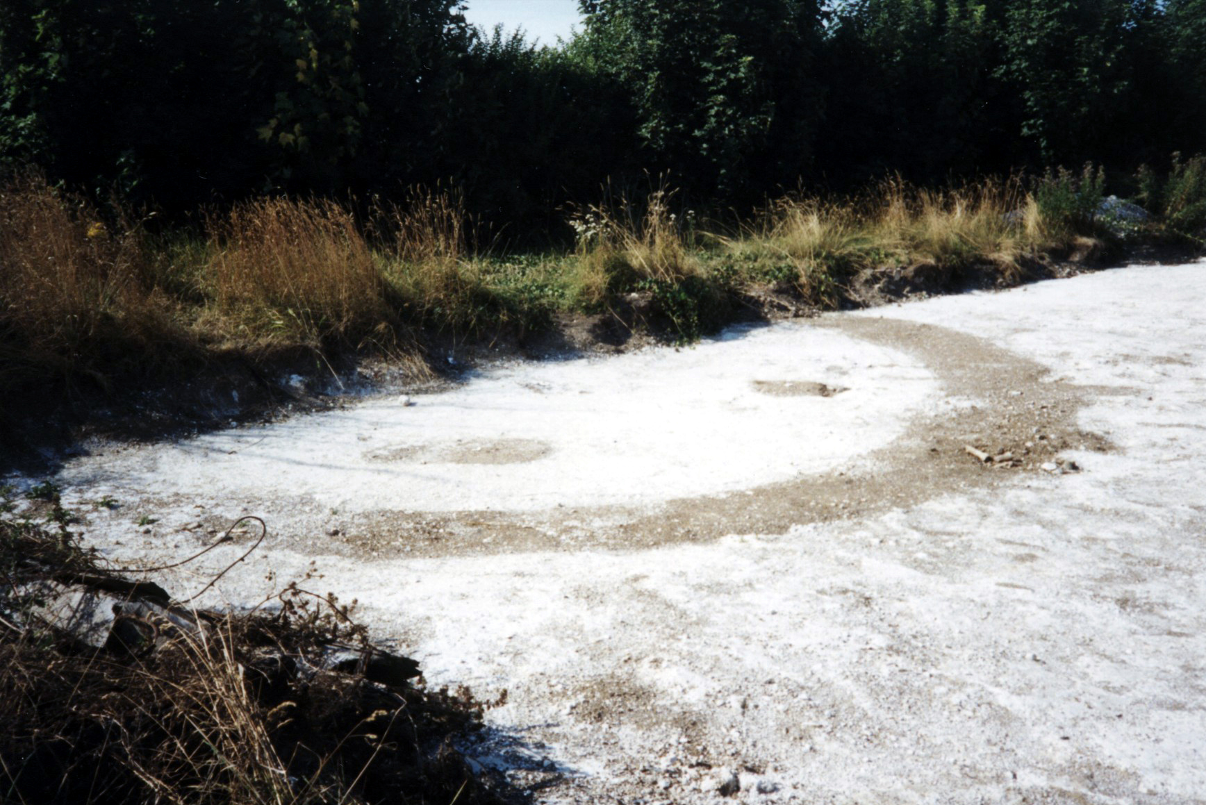
This small barrow was around 10m in diameter and had a narrow causeway (0.40m wide) to the north side of the monument.
The ditch was not perfectly circular (few are). Some parts of the ditch circuit had been cut in slightly straight-ish sections which gives a somewhat segmented appearance to the monument as a whole.
Could this have been the result of the ditch being dug in a series of pre-defined sections (D.R.J. Perkins), perhaps as a communal task by several individuals within a family or small community group? That presents a nice image, but must remain forever speculation.
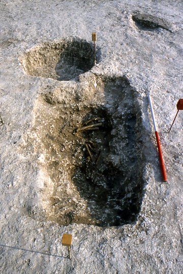
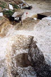
At the top right is the second grave in an oval pit
Two other small pits lie behind the central burial
Several small post-holes can also be seen
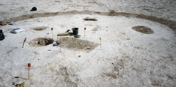
The true relationship between the pit and the central rectangular grave is not entirely clear
Has the pit avoided cutting the earlier grave, or vice versa? The pictures seem to suggest that the grave may be respecting the edge of the circular pit
Personally I feel that the pit may have been dug as a result of the ceremonial activities which surrounded the interring of the primary grave and/or the founding of the Causewayed monument
Perhaps this small enclosure had a previous life as a family's private ceremonial monument before being used as their burial ground? Several small pits and post-holes were found within the enclosure
Many other interesting possibilities exist - see further below!
All ideas are worth exploring in an attempt to help us perceive the lives of our ancestors who walked the hilltop at North Foreland some 4000 years ago
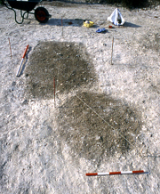
Scale in 0.1 metre divisions
Photo by TTA
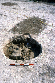
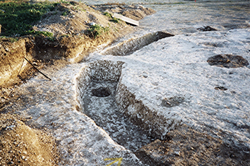
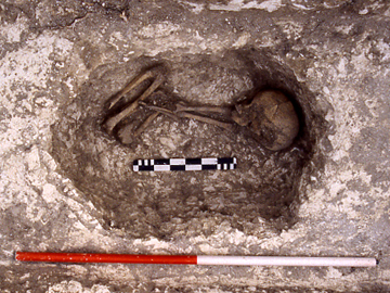
The second, outer grave and the remains of its occupant
It lay to the south-east of the rectangular central burial
The grave was only around 0.30m deep, but the surviving soil backfill suggested that the body may had been laid within a wooden coffin-structure (Boast, Gardner and Moody 2006).
A second, oval-shaped grave was situated to the south-east of the first and this contained just a few fragments of human bone. Little could be learned from these remains, save that they represented a single individual, laid in a crouched position with their head to the west end of a virtually east-west aligned grave.
why were these particular individuals selected for burial here and what happened to the remains of the rest of what must surely have been been a much larger family group
Did they get their own roundbarrow or flat-grave burial elsewhere?
Or were their remains treated in an entirely different fashion - one that left no trace for us to find today
North is approximately to the top of this picture
Scale is in 0.5 metre divisions
Photo by TTA
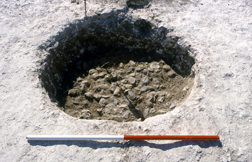
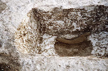
Scale in 0.1 metre divisions
Photo by TTA
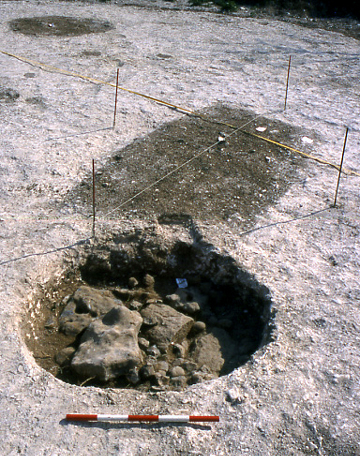
Close to the rectangular central burial was a circular pit which contained a mass of burnt flint nodules capped by four larger pieces of beached-sourced tabular flint and four slabs of sandstone (of non-local Greensand/Ragstone perhaps; Boast, Gardner and Moody 2006).
The heating of nodules of flint for use as pot-boilers and also for providing the raw material of a tempering agent used in pottery production (though employed much less frequently in the Early Bronze Age) was a widespread practice throughout the Neolithic, Bronze Age and Iron Age.
However it is very unusual to find such a mass of burnt flint buried within a feature. The capping of this deposit with large slabs of flint and sandstone seems to suggest an act of purposeful deposition and may be one that was either connected with the burial rites conducted at this monument, or perhaps its founding.
Photo by TTA
However, around 2000 BC the coastline could have been approximately another 1.2km distant (Perkins 1999).
It could be that 'the pit represents a post hole with the flints providing a pad for a large post acting as a marker possibly relating to the phase of activity which includes the use of the Barrow causeway, the insertion of the burial into the Barrow ditch and its subsequent backfilling' (Boast and Moody in Boast, Gardner and Moody 2006).
This view appears to have greatly influenced the position of the monument and the orientation of the causeway and the central burial
A couple of the small, shallow pits can be seen to the right of the picture
The Wantsum Channel was a much safer route, but one that may have been strictly controlled by some of the inhabitants of the Isle of Thanet, perhaps allowing the creation of a rich 'Gateway Community'.
The potentials and limitations of Prehistoric sea-going boats is another subject entirely of course (and one about which I know little!)
Recently the focus of an article in Archaeologia Cantiana by Thanet Trust's former Director Dr. David Perkins, we may return to this topic in the future!
Given the barrow's position
overlooking a valley which leads north-eastwards to the sea, the idea
of a large post which could have acted as a landmark or seamark is
quite attractive.
Could this have been an original
feature of the monument, or perhaps a later Iron Age addition (a few
scraps of Iron Age pottery were recovered from the pit, but are thought
to be intrusive). Could it have
been a
navigation aid, perhaps helping boats to target a landing at Joss Bay
on their way to the Iron Age hill-top settlement (Moody pers comm.)?
A recent review by Ges Moody of the linear cropmarks which can be seen running along the side of the hill show that they descend towards the valley bottom at Joss Bay and this has led him to a new interpretation that they may represent (multi-period?) trackway ditches rather than the defensive ditches of a 'hillfort' or hill-top settlement.
A recent review by Ges Moody of the linear cropmarks which can be seen running along the side of the hill show that they descend towards the valley bottom at Joss Bay and this has led him to a new interpretation that they may represent (multi-period?) trackway ditches rather than the defensive ditches of a 'hillfort' or hill-top settlement.
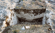
A small grave was cut
into the
base of the ditch to the west of
the causeway. This is a
unique feature for a
Thanet
roundbarrow and
is quite probably a rare occurrence
generally.
A large fragment of whalebone
had been placed across this
grave, a little to one side.
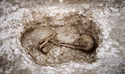
Within the grave were the remains of a
child, perhaps between 9-10 years of age (of unknown sex). The body had
been laid in a crouched position on its right-hand side, with the head
facing south-east. The tightly crouched position suggests that child's
body may have been bound or wrapped before it was placed within the
grave (Boast, Gardner and
Moody 2006).
Once backfilled, a large fragment of whalebone had been placed across one side of the grave. Whalebone is found only rarely on excavations in Thanet. This piece presumably came from a carcass that could have been washed up on a local beach and was likely viewed as a rare and prized resource.
It appears that the whalebone would not have been visible on the surface however, for it had been covered by a small mound of earth which overlapped the edge of the grave-cut. It also appears that the barrow ditch had been purposely backfilled 'soon after the burial had been inserted' (Boast, Gardner and Moody 2006).
Large scale in 0.5 metre divisions
TTA - Trust for Thanet Archaeology.
Its a fair cop!
Bibliography
Boast E.J., Gardner O.W. and Moody G.A. 2006. Excavations at St. Stephen's College, North Foreland Broadstairs, Kent. Trust for Thanet Archaeology report.
Fisk P.M. 2003. An examination of the excavated ring ditch enclosures on The Isle of Thanet. Unpublished Degree thesis.
Perkins D.R.J. 1999. A Gateway Island. Unpublished Doctoral thesis.
Acknowledgments
I should very much like to take this opportunity to acknowledge the work of archaeologist Trevor Beale (pictured left). He excavated much of this important monument and worked extensively on Thanet's archaeological sites over many years, making a major contribution to the exploration of our heritage (and on-site entertainment). Thanks Trevor!
Version 1 - Posted 21.10.06
All
content © Trust for Thanet Archaeology