Category Archives: Landscape

VM_365 Day 61 A map is more than a sum of its parts

Reconstructed map of Roman Thanet
A map of Roman Thanet imagined

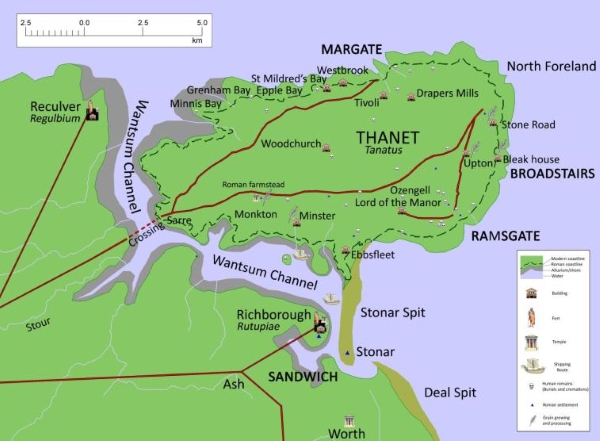
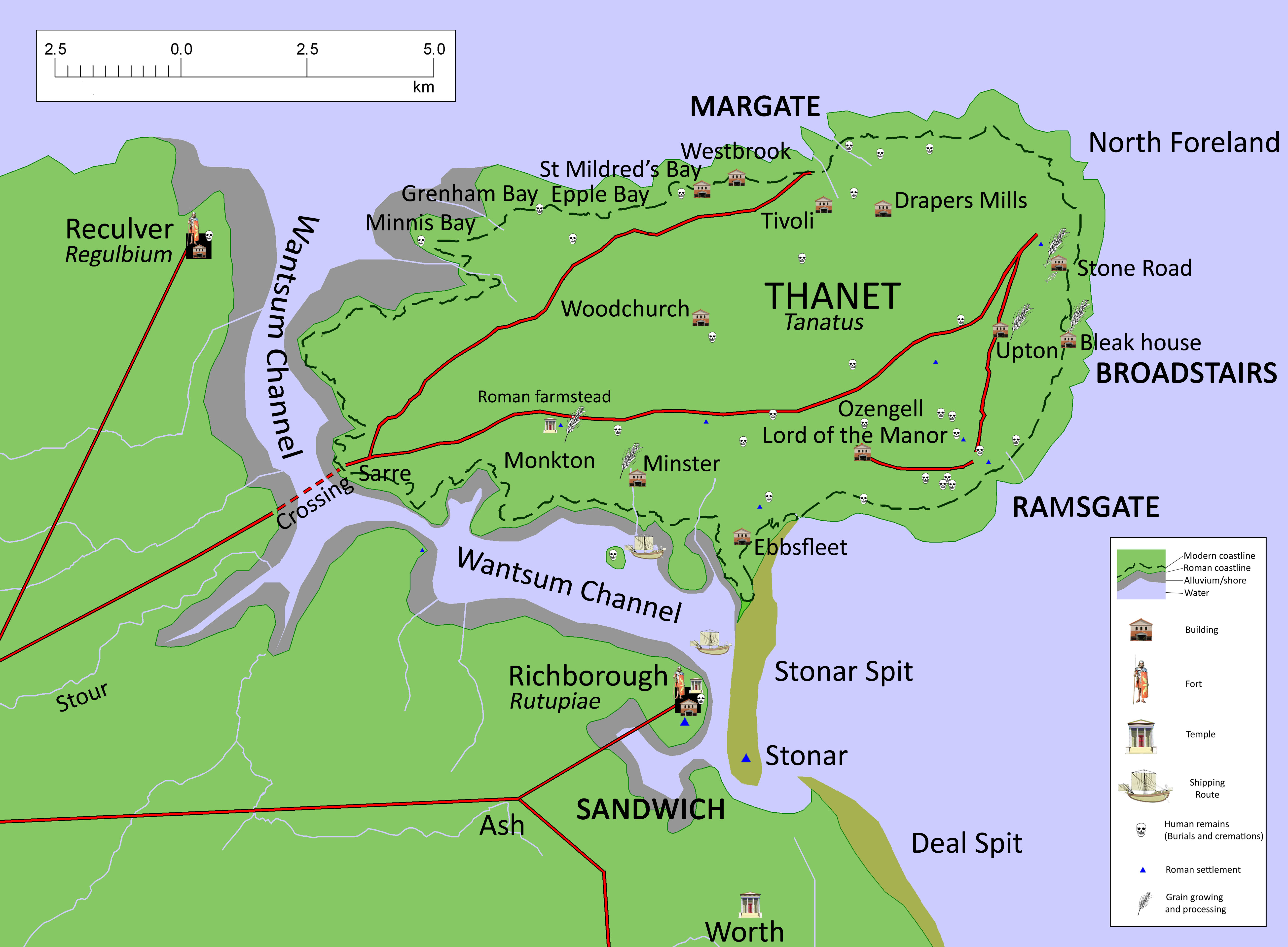
Today’s image for Day 61 of the VM_365 project shows a map of Roman Thanet that was produced to accompany an exhibition called Roman Thanet Revealed, which was curated by volunteers and was on display at the Powell-Cotton Museum in Birchington from April to October 2011.

The map showed an up to date list of major Roman sites that have been identified on Thanet, including the new buildings that had recently been discovered at Upton, Stone Road and Fort House, Broadstairs (shown as Bleak House on the map), as well as the villa at Minster. The map was created to illustrate the locations of the various items on show and to place the discoveries into the context of the networks of roads, towns and forts that would have formed the central places in the Romano-British community.

A map like this serves a number of purposes. It records the location of the discoveries that have been made by archaeologists in specific locations, but it also allows connections to made between the sites and the landscape that they stand in which helps to create a narrative of similarities and differences within the period and to suggest interactions between types of sites and locations .

Recent research has shown in detail the changes that must have taken place in the coastline of Thanet since the Roman period and this map suggests where the Roman coast line might have been. Archaeological evidence in the form of recently rediscovered records and finds from a Roman cremation burial and structure from Boxlees Hill within the channel, show clearly that the  Wantsum Channel which separated the Isle of Thanet from the mainland of Kent was not as open and navigable as was once thought.  It is shown in the map with a wide margin of tidal silts with only the central channel open to the passage of ships.

Several recently published histories of Roman Britain have underestimated the density of settlement in Thanet in the Late Iron Age and Roman period, perhaps because some sites have remained unpublished and also because there is no permanent place to show and promote Thanet’s archaeological remains. As the Roman Thanet Revealed exhibition ended, our Roman history went once more into relative obscurity.

Further reading:

The ancient landscape of Thanet from the Ice Age to the Anglo-Saxon period is explored through a series of revealing historic maps of Thanet and new reconstructions based on geological and archaeological detective work in the book St. Augustine’s First Footfall which is published by the Trust for Thanet Archaeology.

The story of Thanet’s Archaeology from Prehistory to the Norman Conquest was explored by the Ges Moody of the Trust, using a series of maps and archaeological evidence. The Isle of Thanet from Prehistory to the Norman Conquest is available from all high street bookshops and online  book-sellers.

Download a higher resolution version of the map here

VM_365 Day 52 Seaside Archaeology

VM_52

If you are out and about on Thanet’s beaches this coming Bank Holiday, or, come to that, any time of year, keep an eye out for features such as this appearing in our chalk cliffs or in the wave cut shelf on the beach.

This medieval well shaft was exposed at Cliffsend in 1985 following a chalk fall and recorded by the Isle of Thanet Archaeological Unit.  Over the years Iron Age features, including pits and ditches, have been recorded at Dumpton Gap and prehistoric, Roman and Medieval features in the bays between Westgate and Birchington. The bases of Roman well shafts have also been recorded on the beach at Reculver.

So, keep your eyes peeled because you may spot a piece of Thanet’s Archaeological heritage on one of your seaside walks.

P.S. Please remember that cliffs can be dangerous and keep an eye on those tides while you are out and about.

VM_365 Day 29 What lies beneath the cropmark rings?

Circular ditch at North Foreland, Broadstairs showing in chalk geology after plough soil has been removed.

We know from the image in Day 28 of VM_365 that the locations of  the prehistoric burial mounds of Neolithic and Bronze Age Thanet can still be traced from the influence they have on the growth of the crops in the fields that lie over them.

Today’s image, taken at a site at North Foreland near Broadstairs, shows what happens when the thin skim of plough soil that overlies the ditches is removed by archaeologists, using a combination of a carefully controlled mechanical excavator and a final clean up using hand tools.

Once the earth filled ditches and pits underlying the plough soil has been exposed, planning and recording can take place before any further excavation is carried out to examine how deep the surviving ditches may be, and to recover any finds that can help to give a date for the feature.

Careful attention is paid to the irregular patches of dark soil that are enclosed within the ditch because these may be contain the burials that were marked by the ring ditches and their associated mounds as enduring features in the landscape . Other burials were often inserted later, when the mound and ditch surrounding the burial had become a familiar feature in the landscape.

At this stage an archaeological site which was previously known only through images holds the potential to produce physical evidence for the past.

VM_365 Day 22 – Margate Epigraphy

Many layered memories of Margate

A palimpsest of texts inscribed on the cliff face west of Margate. Who is Violeta, what was special about 1935, is I Steve a vision of the future?

This is just a few metres of an immense  running inscription, unfolding a theatre of memory and an archaeology of seaside experience.  Will this record be pored over for its meaning in the future or are these human experiences as enduring as the chalk they are written on?

Go and see it one day, see who you can find.

Lowering skies and wandering shingle

Storm clouds over Ramsgate

Winter of the Coast of Ramsgate

On a rainy day in the winter you might not think that there was much of archaeological significance to see on Thanet’s coast. However, the wind and high seas of January and February are causing one of the most important phenomena of the coast of the Isle of Thanet. the raging seas are driving thousands of flints up the beach, battering at the feet of the chalk cliffs.

Waves driving shingle up the beach at Ramsgate

If you’ve ever wondered why cliff falls  happen so often along Thanet’s coast in stormy weather,  you don’t need to look any further than the relentless pounding these little grey hammers  give to the chalk with each wave that rushes to the shore. Eventually the lower reaches of the cliff face are hollowed out by the rolling cobbles, the chalk above isn’t supported at the base any more and  something has to give and down comes another stretch of the coast in a spectacular fall.

The process has a proper name – ‘Corrasion‘ and has  been going on for a many centuries. John Lewis, the great 18th century historian of Thanet, wrote of ‘the rage of the sea and the falling of the land’ and recounts that in his time a Roman wall had fallen into the sea near the cliffs at Dumpton. Even now pits, ditches and graves of our ancient past are occasionally exposed at the cliff faces around the coastline, soon falling to the beach below.

Inage of Shingle at the foot of the cliff
Shingle at the foot of the cliff
Shingle bank with wave cut steps
Shingle bank with wave cut steps east of Ramsgate harbour

The waves and tides have another effect, collecting great banks and drifts of flint shingle in the shallows where the chalk has been cut to form a flat platform. One bank lies  off the coast at Ramsgate, to the east of the harbour, growing and shrinking over time and occasionally, when the tide is unusually low, it is possible to walk far out along its length.

Some of the flints bound up in the depths of  bank are  irregular nodules of huge dimensions, pitted with undulating depressions and pierced with holes. Before the stone harbour was built Ramsgate’s haven was shielded by a similar deep bank of shingle braced with timber breakwaters. Some timber piles that were destroyed when the slipway in Ramsgate Harbour was built were thought by one observer, a former Harbour Master at Ramsgate, to have have dated to the Roman period. Perhaps the great Stonar Bank, which once stretched across Pegwell Bay and was once firm enough to support a medieval village, looked something like this .

Shingle bank east of Ramsgate harbour

In Thanet the record of the power of the sea to shape our landscape is all around us and has been present since the earliest times in our history.