Category Archives: Bronze Age

VM_365 Day 28 Seeing the Bronze Age past beneath the soil

VM 28

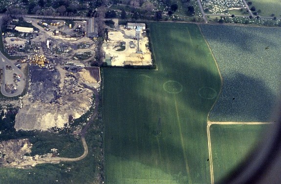
Another image today from our slide archive taken in the early 1990’s, showing how we know so much about the past of the Isle of Thanet without even touching the ground.

The image  shows the cropmarks of two ring ditches, located in the fields behind Margate cemetery and council tip. These cropmarks undoubtedly represent the enclosures of unexplored Bronze Age burial mounds, just two of many hundreds of such features that are known to exist on the Isle of Thanet and have been identified in aerial photographs.

Many unsubstantiated ideas have accumulated around the huge number of these ring ditch cropmarks and the prestigious burials they represent, including a spurious association with Procopius’s ‘Island of the Dead‘ legend. However, their frequency and survival in the landscape undoubtedly contributed to the name that was given to Thanet as a territory in the early political divisions of Kent.

In the Domesday survey of the 11th century, the Isle of Thanet constituted  a ‘Hundred’, a collection of a hundred smaller divisions of plough land called hydes. Known as the ‘Hundred of Ringslow’, the Hundred of ‘ring-mounds’, the name shows that the Bronze-Age past of the Isle had a lasting influence on the area.

VM_365 Day 26 – Middle Bronze Age Cremation Urn from Ramsgate

VM 26
Middle Bronze Age cremation vessel, its location in a shallow pit with two other vessels is shown on the right

A small ring ditch cut into geological deposits was exposed in an excavation on the Westcliff at Ramsgate, carried out in 2002 on the site of a new housing development.  Irregular flint nodules spread over the area of the  ditch and retained in the soil that filled it suggested it may have been covered by a cairn.

Pieces of a coarse flint tempered vessel found at the base of the ditch,  linked the date of the ring ditch with that of a group of five truncated pits that were nearby. Each pit contained between one and three coarse flint tempered ‘Deverel-Rimbury’ style pottery vessels, all but one inverted so that they stood with their rims on the base of the pit. The bases of the vessels, which had been uppermost in the pits, had  been disturbed and destroyed at some later time.

Fragments of burnt human bone were distributed irregularly within the soil that filled each vessel. The burnt bone seems to represent material that had been collected from cremation pyres and placed in the vessels, rather than all that remained of the cremation of a single individual.

Today’s picture shows one of the pits (Pit A) being excavated, alongside a photograph of the best preserved Vessel 4, a straight sided, narrow mouthed bucket urn in a coarse flint tempered fabric, decorated down each side with two rows of finger tip impressions. The urn is inverted and stands on its rim as it did in the cremation pit.

All three vessels from Pit A contained cremated bone fragments, two with identifiable bone elements representing two individuals, a child around 10 years of age and an adult. Radiocarbon dating of a fragment of bone from one of the individuals gave a  date  between 1520-1310 BC, within the Middle Bronze Age.

There’s  more about the Middle Bronze Age in Thanet in the Virtual Museum’s Bronze Age gallery.

You can find out more about this site in the published report:
Moody, G., Macpherson-Grant, N. and Anderson, T. 2010. Later Bronze Age Cremation at West Cliff, Ramsgate.  Archaeologia Cantiana CXXX 147-172.

VM_365 Day 21 – An ancient past no one can see

Image of excavations at Lord-of -The Manor Ramsgate in 1976
Excavations at Lord-of-The-Manor Ramsgate in 1976, revealing the ancient landscape hidden by the plough

The Trust for Thanet Archaeology is an educational charity and one of its aims is to teach people about Thanet’s very important past history, which has been revealed through archaeological investigation.

One of the problems faced by the Trust is that much of our archaeology remains hidden from view under the wide expanses of agricultural fields that cover the Island. Take a close look at the area surrounding the excavation in the image, which is as flat and featureless as any field could be. Yet below the thin covering of top soil are the remains of a prehistoric site, formed of several succeeding ring ditches that were used and adapted for many different ceremonies and burials from the Beaker period to the Bronze Age.

The importance of Thanet’s landscape in the past partly derived from the fertile soils  and relatively warm weather, where the climatic conditions on this south east coast were not dissimilar to those of the near continent. For prehistoric peoples, the interaction with the coastal areas of Britain were not such a great leap as they would have been if the conditions were closer to those in the north of the the British Isles. The combination of close European connections, openness to innovation in culture and the fertile landscape, led to the formation of a dense record of past settlement that has been discovered in the Isle of Thanet.

Sites like the Lord-of-the Manor ring ditches shown in the image tell the earliest part of Thanet’s story , but their significance can really only be comprehended by looking at the records, reports and images that remain from the archaeological efforts to discover and investigate them. The intensification of agriculture from the medieval period onwards levelled the remains of the settlements of preceding generations, until only the truncated remnants lay buried under a swathe of plough soil, covering miles of flat ploughed fields.

Over time, each  generation has done its best to prosper in the soil. For many centuries much of the landscape was in use as grazing land and we have archaeological evidence that ancient barrow mounds and ditches remained standing in the landscape in the Roman period. As late as the 19th century earthworks and mounds remained in the Lord-of-the Manor area of Ramsgate, where today’s image was taken during excavations in 1976.