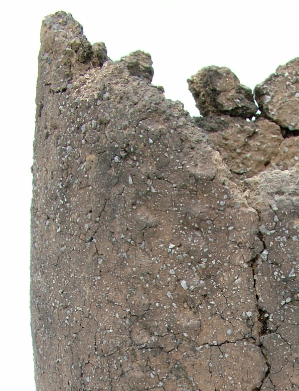
If you look carfeully at this close up of the fabric of a Middle Bronze Age pottery urn from Ramsgate you can see two aspects of human interaction with the landscape which are preserved at a relatively small scale in an everyday object.
The material was worked by the potters into the common forms that were part of their culture but the feel of the material was a direct reflection of the immediate landscape of the potter. Each region may have shared common vessel types, which could be transmitted through examples and ideas, but the materials the vessels were made from were gathered locally and were usually distinctive in their fabric which were rooted in the local landscape.
Bronze-Age round barrow on hilltop overlooking Pegwell Bay
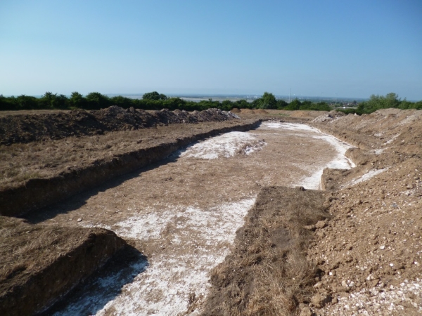
How does an archaeological site reflect its landscape? This image for VM_365 Day 63 shows how important location within a landscape is for the choices that are made on where to live, work and celebrate.
Bronze Age round barrows like this one at Ramsgate were formed by digging a circular ditch into the hard chalk of the hillside to create a mound in the centre from the spoil from the ditch. Very frequently, but not in every case, the central mound covered the burial of an individual which was itself laid in a chamber created by cutting a rectangular pit into the chalk.
But what motivated the choice for the location of each round barrow? This image contains one answer to this question in the vista over Pegwell Bay which can be seen beyond the section of the ditch revealed in the trench. From this position the land from Deal, the eastern mouth of the Stour and the mouth of the valley of the Wantsum, sweeping through to the northern side of Pegwell Bay where the open sea was visible beyond the land. On a clear day the cliffs on the coast of France can also be seen on the horizon from this location.
In general, similar Bronze Age funerary monuments in Thanet have been found in commanding locations on the convex slopes of hillsides and valleys which the undulating chalk downs of Thanet possess in abundance. In each location the commanding view demonstrates that the position was carefully chosen and surveyed to assess the suitability of the site.
Before we interpret the motives behind such choices of position, we need to consider that the landscape has changed from that of the Bronze Age through coastal erosion and sea level rises. The Bronze Age barrow burial rite also lasted some centuries and within the monuments recorded we need to consider what influence the choices of earlier people had as time passed.
Many of the best sites may have been taken at an early stage, or perhaps the best locations were identified and rationed in some way that was determined by the culture and contemporary ideas of rights and status. To date there has been little evidence that barrows were partially overlapped to usurp the space taken by an earlier monument, although we do have evidence that the ditch of an earlier barrow was re-excavated and trimmed, possibly to accommodate a new burial. Perhaps it was acceptable to re-use a barrow, respecting and associating a new person with the personality and status of the earlier burial, but it was not acceptable to damage an earlier barrow and erase the memory of the significance of the earlier burial.
The landscape seems to have had a deep resonance in the culture of Bronze Age Thanet, although we can only work out the ways these were turned into cultural forms by reasoning from our data on the location of features within the landscape and considering the logic of the placement of the sites within the space and land forms that were available. In short, archaeology loses an important dimension if context within its landscape does not form part of the archaeological investigation that is applied to it.
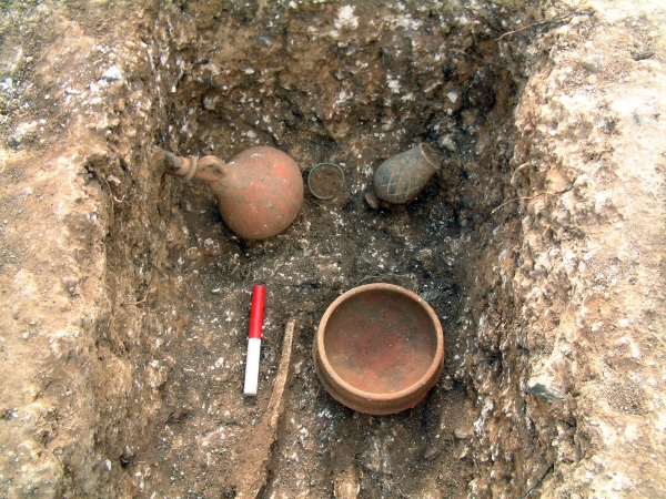
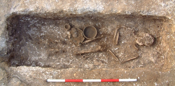
Following on from Day 56’s image of one of the Roman graves excavated at Grange Road, Ramsgate, today’s image shows one of the grave assemblages from the same site.
This assemblage was found in the grave of an adult female who was buried wearing a copper alloy twisted wire bracelet and was wearing foot wear with hobnails. The assemblage you can see in this picture was found at the foot end of the grave and included a second copper alloy bracelet, a pottery dish, a flagon stoppered with a flint and a beaker. If you look carefully, you can also see a length of copper alloy wire, near the dish that may have been twisted around a fabric bag.
It was items like this that Hicks was recovering in the new developments in this area of the town in the 19th century.
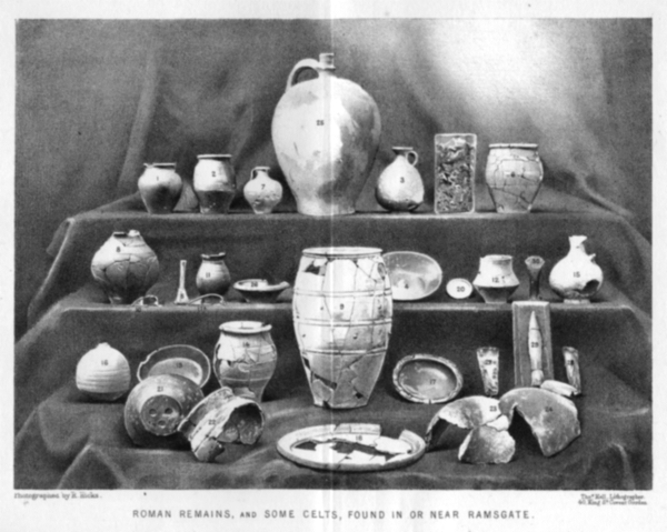
Photograph of artefacts found in or near the Ramsgate area published by Robert Hicks MRCS in 1878
Following on from the image of a Roman burial at Ramsgate from VM_365 Day 56, today’s picture shows a collection of archaeological artefacts from private collections that were discovered in Ramsgate before the photograph was published in an article for Archaeologia Cantiana, the journal of the Kent Archaeological Society, in 1878.
Ramsgate was lucky to have one of Thanet’s most diligent and learned pioneering archaeologists in Robert Hicks, a surgeon who joined Ramsgate’s Seaman’s Infirmary & General Hospital in the middle of the 19th century and maintained a keen interest in the local archaeological discoveries that were being made as the town expanded. Hicks deserves to better known in the story of Ramsgate’s cultural heritage and it would serve the town well if more biographical details could be added to his own story by some local researcher.
Robert Hicks oversaw the collection and photographing of the artefacts and and wrote the article that it illustrated. To accompany the picture in the published article, reproduced in the image above, Hicks listed the location where each of these finds was made, giving a brief description and dates for each of them as current archaeological knowledge stood.
While his focus in the article was predominantly in the abundant finds of the Roman period, several of the artefacts shown in the picture published in the 1878 article are certainly from earlier periods in prehistory, including Mesolithic, Neolithic and Bronze Age axes and what seems to be a finely made Early Bronze Age flint dagger. Two Iron Age fibula brooches are present, along with several late Iron Age ‘Belgic’ pottery vessels.
Sadly none of these artefacts can be located today and Ramsgate’s heritage is poorer for the loss of a collection of artefacts that would grace any local museum and would contribute to telling a longer and more complex story of the area than is generally known to the town’s residents. Now only Hicks’s published photograph exists to help us understand what we have lost.
Reference
Hicks R. 1878. Roman Remains from Ramsgate. Archaeologia Cantiana Vol.12, p.14 – 18.
Our Image for VM_365 today is of a Roman burial found in Ramsgate, which gave us important evidence confirming the records of early archaeological discoveries in the town.
For much of the 19th century Ramsgate was spreading out from its early limits, clustered along the High Street and around the harbour. Suburbs with bungalows, large houses, terraces and squares began to spread out on the upper reaches of the East and West Cliffs, the town expanding into what had been open fields and parade grounds and camps during the Napoleonic Wars.
In the course of the development that took place, many archaeological sites were disturbed and important evidence of the long occupation of the area was revealed. Luckily Ramsgate in the 19th century was home to a lively community of local historians and pioneering archaeologists and many documentary and even photographic records were made and published.
Several Roman burials had been reported on the West Cliff, in the area of the southern end of Grange Road, London Road and West Cliff Road, suggesting that the West Cliffs were the site of groups of Roman burials if not a more extensive cemetery.
Unfortunately few of the artefacts or sites could be re-examined using modern archaeological methods and the interpretation and dating given by the early researchers could not be tested. Much of the evidence could only be regarded as ‘background’ information which could not be taken at face value until more data could be gathered. What was needed was archaeological evidence that could be analysed using modern methods and allow a more accurate assessment to be made of the early records.
In 2007 an excavation at a site in Grange Road provided the archaeological confirmation that was needed when a group of five intact graves were discovered, surviving remarkably just beneath the foundations of a demolished building that had been cleared from the site.
The five graves could be excavated using modern methods and the accompanying finds analysed in detail and accurately dated, showing that the group dated to the late 3rd or early 4th century. Without doubt more remains to be found of Roman Ramsgate. Records suggest that a Roman building once stood near the harbour and archaeological confirmation of the settlement where these Roman people lived would put Ramsgate firmly on the map of Roman Britain.
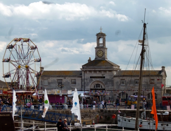
The image for Day 55 of VM_365 celebrates Ramsgate’s rich architectural heritage.
In Britain many buildings are listed by English Heritage for their outstanding historical or architectural merit and Ramsgate has one of the highest densities of listed buildings in the country.
The Clock House at Ramsgate Harbour, currently housing the Ramsgate Maritime Museum, is one of the 5.5% of buildings that enjoy a II* listing, regarded as particularly important buildings of more than special interest.
The early work to construct Ramsgate Harbour was undertaken by John Smeaton between 1774 and his death in 1792. In 1794, after a trial period following Smeaton’s death, Benjamin Wyatt took over as engineer for the Ramsgate Harbour Trust. Although Smeaton had completed the basic structure of the harbour, Wyatt was responsible for maintenance and the construction of additional harbour buildings and he produced designs for several improvements and new structures.
On Wyatt’s death on 7th February 1807, he was succeeded as engineer for the Ramsgate Harbour Trust by the Scottish civil engineer John Rennie who had carried out many architectural projects for the Admiralty and had consulted with Wyatt on his plans for Ramsgate Harbour. The Clock House building was originally designed by Wyatt and George Louch, his deputy engineer who had been appointed in 1801, as a single storey store house and offices. The building was constructed by Rennie in 1817 from their design.
John Rennie’s second son, also called John, succeeded his father in his civil engineering business in 1820 and also as the engineer for Ramsgate Harbour. Rennie junior continued the maintenance and construction works in the harbour, which included the additions that were made to add the upper storeys and tower to the harbour building turning it into the Clock House that we see today.
The operation of a clock and a unique solar meridian established for Ramsgate, 5 minutes and 41 seconds ahead of Greenwich Mean Time, was described by a naval officer in 1837:
‘In the dome is an astronomical clock, and a meridian line, fixed, by means of a wire, which is used to ascertain its error, for the purpose of rating the chronometers of vessels entering the port…’
The original clock was built by John Moore and Sons of Clerkenwell under the supervision of physicist Henry Kater who had made advances in the design of astronomical clocks. A brass transit line marking the Ramsgate meridian was set in the first floor of the Clock House building until it was stolen in 1975.
Accurate time pieces were essential to navigation in the early 19th century and their calibration to the fundamental Greenwich Mean Time datum was equally important. Many harbours had prominent clocks that could be observed and used to calibrate on-board navigational clocks by ships that entered the ports.
In 1846 the clock in the tower was replaced with a new clock mechanism made by London clock maker Edward John Dent. With four, 5ft diameter gas lit dials, operated by rods to keep the mechanism away from the gas lights, the mechanism was housed in the dome along with the meridian apparatus. At Dent’s suggestion, from the 1st of November 1848, the new clock at Ramsgate showed Greenwich Mean Time, bringing an end to Ramsgate’s idiosyncratic time zone.
Reference:
Anon. 1837. A brief history of Dover and Ramsgate Harbours; with a description of the Coast, between Dungeness, and the Isle of Thanet, and remarks on the probable construction of a Harbour, between the South Foreland and Sandwich Haven. By a Naval Officer. London.
Matkin R.V. 1976. The Construction of Ramsgate Harbour. Transactions of the Newcomen Society, 48(1), pp. 53–72
Robinson J. M. 1973. Samuel Wyatt at Ramsgate. Architectural History Vol. 16, (1973), pp. 54-59+95-96
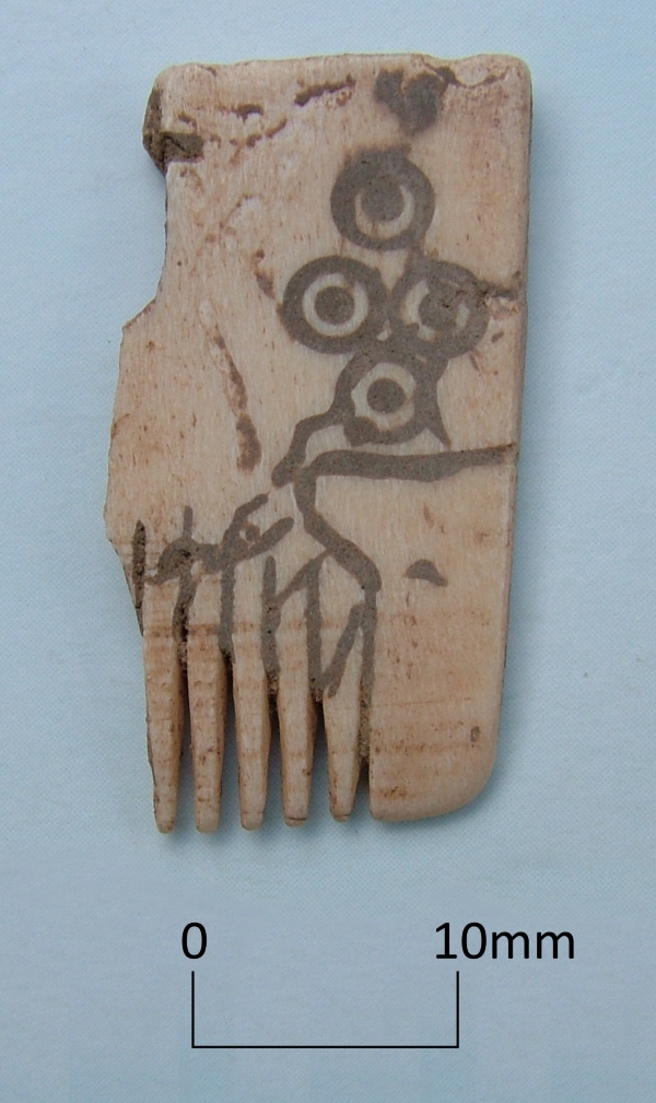
Today’s image shows a fragment of a comb carved from a piece of ivory. The surface is inscribed with curving lines and a dot and circle pattern and was found in an 8th to 9th century refuse pit at Cliffsend in 1998.
Comparable combs have been associated with the Viking period of the 8th-9th centuries and although Thanet is mentioned in historical records of Viking raiding, we have few archaeological finds from the period.
In the same pit, along with pottery and other objects, was the skeleton of a Cod estimated to have weighed about 18 kilogrammes (40lb) which tells us something about the contemporary economy and ecology of the 8th-9th century.
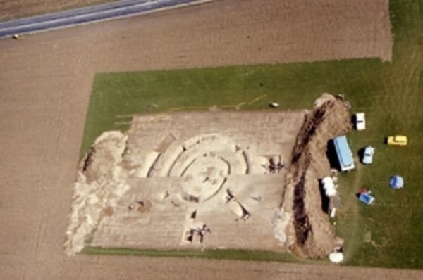
Excavations at Lord-of-The-Manor Ramsgate in 1976, revealing the ancient landscape hidden by the plough
The Trust for Thanet Archaeology is an educational charity and one of its aims is to teach people about Thanet’s very important past history, which has been revealed through archaeological investigation.
One of the problems faced by the Trust is that much of our archaeology remains hidden from view under the wide expanses of agricultural fields that cover the Island. Take a close look at the area surrounding the excavation in the image, which is as flat and featureless as any field could be. Yet below the thin covering of top soil are the remains of a prehistoric site, formed of several succeeding ring ditches that were used and adapted for many different ceremonies and burials from the Beaker period to the Bronze Age.
The importance of Thanet’s landscape in the past partly derived from the fertile soils and relatively warm weather, where the climatic conditions on this south east coast were not dissimilar to those of the near continent. For prehistoric peoples, the interaction with the coastal areas of Britain were not such a great leap as they would have been if the conditions were closer to those in the north of the the British Isles. The combination of close European connections, openness to innovation in culture and the fertile landscape, led to the formation of a dense record of past settlement that has been discovered in the Isle of Thanet.
Sites like the Lord-of-the Manor ring ditches shown in the image tell the earliest part of Thanet’s story , but their significance can really only be comprehended by looking at the records, reports and images that remain from the archaeological efforts to discover and investigate them. The intensification of agriculture from the medieval period onwards levelled the remains of the settlements of preceding generations, until only the truncated remnants lay buried under a swathe of plough soil, covering miles of flat ploughed fields.
Over time, each generation has done its best to prosper in the soil. For many centuries much of the landscape was in use as grazing land and we have archaeological evidence that ancient barrow mounds and ditches remained standing in the landscape in the Roman period. As late as the 19th century earthworks and mounds remained in the Lord-of-the Manor area of Ramsgate, where today’s image was taken during excavations in 1976.
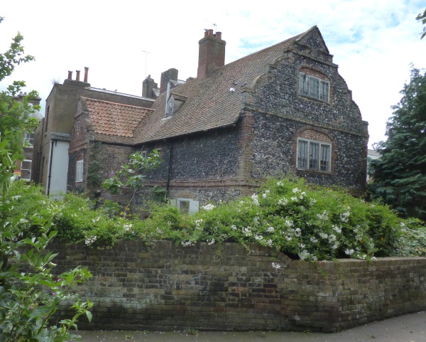
You might think that this pair of Grade II Iisted brick and flint cottages with their Flemish style gables are tucked away in the Kent countryside. These lovely buildings are in fact hidden away behind the shops of Queen Street in Ramsgate. Accessed through a narrow passage called Queens Court they are a hidden gem of the townscape and a window through which we can see something of 17th century Ramsgate.