The Holiday Club at the Trinity Resource Centre in Margate was the scene of another day of archaeological activities on Friday 1st of November.
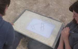
Keystone mosaic
The Dig and Discover boxes were popular as usual, as was the chance to learn about the people of the past, with our skeleton and an impressive re-enactment of the burial of an important Anglo-Saxon warrior, with a discussion of just what might be found of the remains of the impressive costume and weapons the warrior carried.
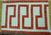
We had some fine mosaics made with great patience and care, following the keystone pattern examples from Greek and Roman mosaics.
Once again we had a really interesting day with our friends at the Trinity Holiday club and we were pleased to be given a fine hand-made Thank You card from all the participants.
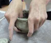
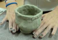
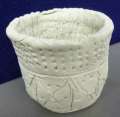
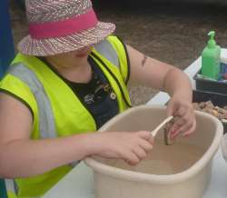
Our pottery making activity saw some ambitious creations, with a two piece set of a cup and tea pot as well as some excellent pots based on the forms and decorations of ancient pottery.
Thumb pot under wayThe finished thumb pot – in the prehistoric styleA pot decorated in prehistoric style
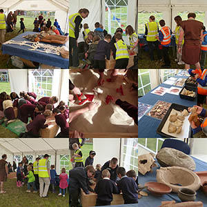
Our three days of Roman themed digging came to an end on the 19th of September with 16 groups of local school children coming through the entrance of our Dig and Discover tent.
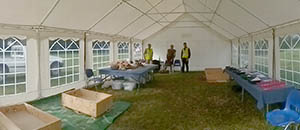
Our Dig and Discover area at Dig for Three Days
Over 240 children took part in the activities on the final day, being introduced to the finds that archaeologists use to discover new information on how and where the Romans lived in Thanet. Dig for Three Days – Roman activities for Thanet Schools
The session began with a display of real Roman artefacts found in Thanet and then a hands on dig to get a feel for what it is like to find ancient objects buried in the ground and how archaeologists piece together the finds and their ideas about the Romans into the story of Roman Britain.
The teams of diggers even got a brief lesson in Latin, learning the words used by the Romans for their roof tiles and special pottery vessels.
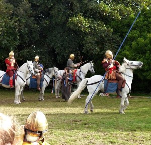
Cavalry display by Roman reenactment group Commitatus
It wasn’t the end of the Roman activities for the week though, and as we packed up our finds, Roman reenactment group Commitatus were bringing their tents, equipment and even horses on to the field to begin two days of displays and activities, ending with the Eagle festival on Saturday 21st of September when Commitatus gave two displays to the public of Roman gladiatorial combat and horesemanship.
The children of Bradstow School gave their performance of the Eagle of the Ninth and the day ended with multi-media performance of the Eagle on Broadstairs beach and a spectacular fireworks display to end the festival.
Much needed storage boxes and mini-grip bags donated from our wishlist
We’d like to take this chance to thank Sue Carter, of Fortified England fame, for making a donation to the Trust of items from our Amazon wishlist, which has items, large and small, that we need, or use frequently, for packaging, cataloguing and storing artefacts and archives in our care, so that they can be kept in good condition.
With no prospect in the near future of there being a suitable museum in Thanet that would be prepared to take on the task of looking after the archaeological finds and archives from historic excavations, we have a long task ahead of us making sure that the finds are kept in good order. Our aim is to organise our stored material so that they can be used as a resource for teaching as many people as possible about the rich archaeological heritage of Thanet, to make our past part of our future.
You can read more about Making our Past Part of our Future, take a look at our web page to see why the Trust needs your support.
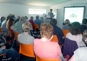
Once again Ges Moody took part in the annual Summer Squall event organised by Ramsgate arts and held over the August Bank Holiday weekend. Ges gave a talk at Ramsgate Library on Saturday morning about St Augustine’s landing in Thanet, based on research he carried out for his latest book. The talk was well attended and despite the distraction provided by a faulty ventilator alarm, proved to be quite enthralling.
Ges’s subject was not a simple regurgitation of the legend of St Augustine’s landing on Thanet; his reconstruction of the landscape, examination of the types of settlements and the costumes of the population of Thanet at that time enabled the audience to imagine a picture of Thanet from the distant Anglo Saxon past. He added further depth and colour by exploring the national and international political relationships of the time, proving to the listener that this was not a simple act of conversion of a pagan people but a more complicated interaction of nations, people and ideas.
The talk was followed by a lively question and answer session, and the opportunity for Ges to sign a few copies of the book!
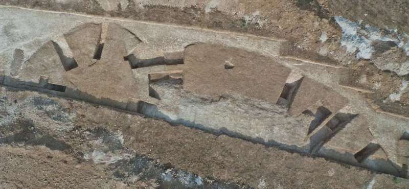
On Thursday morning (that’s Day 9 to LOM training dig enthusiasts) we received a forwarded email from an amateur photographer, Dean Barkley, who carries out low level aerial photography using a quadcopter rigged with a digital camera and was keen to work with archaeological sites.
Quodcopter and camera rig used for low level aerial photography
With a remarkable stroke of coincidence Dean lives in Manston, a short distance form our site and we took a chance on emailing him to see if he would like to visit and photograph our site. Dean visited on Friady morning to show us the equipment but we faced the slight problem that our site was directly under the flight path of Manston airfield, as you will have seen from previous posts. Flights with such an aircraft would not be allowed in the flight path without permission. The good news was that after negotiating with Manston Operations, the control tower did give Dean permission for a flight on Saturday morning which resulted in some stunning images of the excavation. It made all the hard work to clean the site for our final photographs worthwhile and rounded off two weeks with a spectacular flourish.
Aerial overview of the excavation
One could say it put the icing on the cake, but that talent lay elsewhere on Friday and provided us with a few preliminary spectacular flourishes!
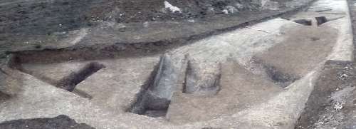
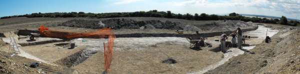
Day 10, final panoramic photo of the site viewed from western side
The last day of the dig has finally arrived. Time to tidy everything up, make sure all the recording is done and finally clear the site for a set of final photographs. Sounds easy?
It is our belief that on an archaeological excavation the last 10% of the work counts for 80% of the information that will eventually be published. The lovely set of final photographs showing all the excavated area in pristine condition, the records of the areas you have been chewing away at without resolving them until the last few hours. All those jobs you put off ; leave recording that section for later, take that photograph later. All these loose ends must be tied up as the site will be over, later has arrived and there is no more later to be had.
All this leads to the state known as ‘final panic’ which coincides with packing up tools equipment and the site cabin as well as resolving difficult stratigraphic issues in the plans and sections.
So, suffice it to say that this final day’s journal entry will be relatively short. All areas are completed, all segments through the ring ditch and deep area have been finished, all the finds are bagged and all the drawing is done.
Keep following the journal over the next weeks to find out what the excavation revealed and to see find out more about the site, its context and the process of excavation on our Trust for Thanet Archaeology and University of Kent training excavation.
It just remains to thank in no particular order Marie-Claire, Emma, Gabby, Scott, Kaneez and Emily from the University of Kent for their hard work and dedication over the ten days and for doing justice to this important site. Also Maggy, John, Niccy and Margaret of the Isle of Thanet Archaeological society, our junior volunteer Katherine and also Simon and Adam for the Trust for their great efforts during the dig. We would like to thank the University of Kent for funding the training excavation and allowing students to have an opportunity to take part in field work on this historic site. We would also like to express our appreciation to the landowner Mr. David Steed for once again indulging archaeologists in their passion for the past on his land.
The project is dedicated to the memory of Dr. David Perkins, the Trust’s first director, in whose pioneering footsteps we have worked during the last two weeks.
Keep following the progress of the analysis of the site here…
Another hot day today with blustery wind blowing dust over everyone.
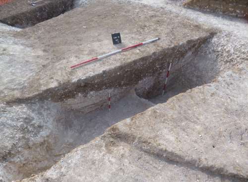
Today segment three, excavated through the northern end of the ring ditch was completed, showing another wide, straight sided profile with a flat base. On the eastern side the ditch is cut by another later feature, which reduced the chalk geology to a considerable depth, truncating the east side of the ring ditch.
Segment 3 fully excavated, ready for photography and recording
The later feature could not be explored further because of the limit of excavation in the trench. In the lowest fill the few finds included a cattle vertebra, located at a similar level within the ditch fills as the skull that was found a few days ago. A struck flint was found in the primary silting right on the base of the ditch cut.
Marking up context numbers on the plan of segments 1 and 2
The first and second segments were planned using a plot of an EDM survey which recorded strings of points along the the breaks of slope that defined the features. The survey plot was used as a base plan over which a hachured scale drawing was made on drawing film. When the drawing was completed, the overlaid plan was marked with the numbers assigned to the various features cut into the chalk geology.
The third completed segment will be surveyed and planned in a similar way tomorrow on our last working day on site at Lord of the Manor.
Processing the pottery
Over the day we were assisted by a young volunteer who took part in the excavation, emptied barrows and processed the pottery sherds we have collected from the excavation and from the spoil around the site. The extra help was very welcome at this stage in our project.
More steady progress was made in the deep feature at the southern end of the trench. A segment cut in from the west side is showing another steep sided profile, and at the limit of the days digging, the upper fill of another curvilinear cut at the base of the segment, probably an inter-cutting pit. At the northern edge, the truncated crest of the ring ditch cut has been traced further were it underlies the later feature. This allows us to trace an accurate plan of the ring ditch circuit as far as possible under the later deposits. As these features are often very regular in plan it is likely the ditch can be accurately projected in the final site plans. On our final day on Friday we will record and survey the segments excavated into the feature, recording the small keyhole insights into the shape and depth of the feature.
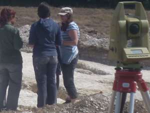
Locating the grave numbers for the EDM survey
Today we turned our attention to another part of our excavation area where we had not yet done any work during this project. We began a digital survey with the EDM of a group of graves belonging to an important early Anglo-Saxon cemetery which had been fully excavated in 1982, leaving only the empty grave cuts showing in the hard chalk geology. The small scale composite plan of the cemetery, which is the only record we have of the layout of the graves, has proved to have significant inaccuracies in the representation of form and distribution of the graves. The small scale plan was consulted to determine the number that had been assigned to the grave cut in the earlier excavation, then the grave was surveyed with the EDM using the staff and prism to trace the outline of the upper and lower breaks of slope of the cut.
Although no burials remain in place, there is much evidence of archaeological value to gain from re-planning the graves. Already we can see that a more accurate plan will help us to determine the order of the burials. We can return to the old records of the site in the future and gain new insights into this very significant site, one of the key research aims of our project.
A lot remains to be done on the final day of the project to complete our field research into this important site, revealing more about the site and the features…
A hot day today, and no gas to boil the kettle in the morning, no tea, no good. Meanwhile work continues at a steady pace.
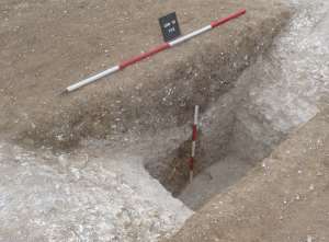
Recording the north facing section of segment 2
Segments 1 and 2 through the ring ditch are being drawn and recorded in detail. A plan of the feature on the east side of the second segment of the ring ditch suggests the feature may be almost rectangular in plan, and another small excavation is attempting to expose the southern corner to confirm the shape and hopefully reveal the stratigraphic relationship with the ring ditch. More about this feature as the excavation progresses tomorrow.
Segment 3, which appears to have been cut on the eastern side by another later feature, has reached a point where both edges of the cut for the ring ditch have been exposed. The sections of the excavation have been trimmed, nice and sharp for photographing and recording in the next couple of days to round of the excavation of the ditch.
For the first time it feels like we are beginning to understand the deep feature at the southern end of the ring ditch. In the record from 1982 it was suggested that the ditch had been cut away by two separate pits on the east and west sides, we can now see that these were part of a complex of pits whose fills have merged with that of a deep central feature.
We finally had to give up digging in the segment on the southern side of the feature as it became too deep to access within the confines of the narrow cut. We have traced the ridge of the upper egdes of the truncated ring ditch some distance into the pit complex, removing part of the fill of a segment excavated in 1982.
Intersection of ring ditch and the deep feature at southern end of the ring ditch
In this area we solved one of the problems thrown up by the preliminary magnetometer survey that we carried out on the site. A large anomaly showed up in an area covered by the trench, which indicated the presence of a major metal object in the ground. The anomaly coincided with the earlier segment excavated through the ditch. We discovered that the steel hinges of a door that was buried in the backfill were undoubtedly the cause of the response. Although it was a useful exercise in prospecting for the appropriate location for our excavation, the anomaly demonstrated the difficulty of re-excavating a site which has been disturbed by excavation in the past.
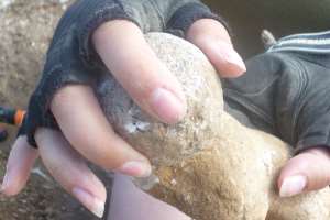
Spherical flint hammer stone or rubbing stone
We have another interesting finds among the mixed pottery sherds we have been getting from the undisturbed areas of the ring ditch, all of which have quite wide date range form prehistoric to medieval. The round flint object is a hammer stone, or rubbing stone, formed by pecking a flint cobble around its whole surface until it forms a rough surfaced sphere. These spherical flint objects are common finds on Bronze Age and Iron Age sites in Thanet and may have been used as a form of pestle for grinding material against another flat stone, or possibly for rubbing and smoothing a hide that was being cured to make leather. It has also been suggested that they were used as a hammer in the process of knapping flint to form more delicate flake tools.
As we come to the last two days of our dig on Thursday and Friday, the final stages of excavating, recording and interpreting this important site will put the team under pressure, but we will make it! Keep following our journal entries for the final results over the next couple of days.
A busy day on site today with a full house team working on all areas of the site. The base of the ditch in the first segment through the ring ditch was found this morning, and a sample taken of the fill at the base. We also found a useful piece of animal bone in the earliest fill, which may be useful for giving a carbon date for the earliest chalky silt deposits that began to settle in the ditch.
Cleaning the ditch for photography, with step ladders for access
Once the base of the ditch was reached, work began to clean and photograph the sections ready for recording. Again we were able to see the wide flat base of the ring ditch, which is perhaps one of the biggest we have seen in Thanet. The depth of the feature presented some problems getting in and out of the steep sided cut, which required specialist equipment – a set of step ladders.
The ditch was comparable the the huge ditches we saw on an excavation by the Trust and Archaeology South East some years ago at Bradstow School in Broadstairs, which were probably the best preserved ring ditch profiles we had seen cut into the chalk geology. The ditch at Bradstow school had a causeway entrance and was unlikely to have been made as a round barrow and was more like a henge like feature. Perhaps the scale of our feature should lead us to think more about what it was built for.
North facing profile of the ring ditch
Another fine job of cleaning and photography will let us think about this feature more when the excavation is over and we consider what we have learned from our work.
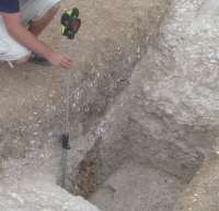
Surveying the ditches with the Total Station EDM
We also began the process of planning the large ring ditch segments using a series of survey strings recording the edges and breaks of slope of the features with our Total Station. There’s a lot of work over the next day or two to fill out the plan of the site and locate the excavated and drawn sections.
In a segment at the intersection of the ditch and the later feature on the northern side we have begun to find some pottery at last, with one or two sherds well stratified in the upper fill. Although this very mixed late deposit appears to have quite a wide range of material, including Iron Age and possibly some Roman.
At the southern end of the site, we continued to explore a segment (now numbered 5) which is attempting to discover the dimensions of the large cut feature that was cut into the barrow. Surprisingly the steep sides of the inner cut suggests the feature is much larger than we anticipated.
East facing segment of segment 5 through the deep feature
Just at the base we have started to reach a deposit of fine ashy material, perhaps this can give us some clues about its origin, although the date remains difficult to establish as we still do not have any more substantial dating evidence.
A visit from our favourite ceramic specialist has suggested that the ceramic handle we discovered a few days ago in the upper fill of segment 2 through the ring ditch, may in fact be Roman. However, a small rim sherd found in the same deposit further south is medieval Canterbury Sandy ware! A very mixed picture and more thought needs to go into the formation of the upper fill. Plenty more to do in our last few days on the dig…
This is our first day back on site after the weekend, a chance to catch up with where we got to and plan for the next few days.
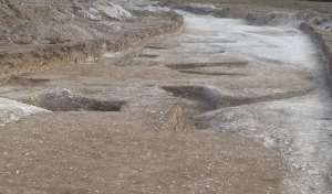
We are beginning to get to grips with the southern part of the site, where the ring ditch is cut away by a later group of pits, or perhaps by a large single pit.
Sections being excavated in the southern part of the site with the ring ditch in the foregound
In places we have had to start emptying a section excavated in 1982, to make sense of the hand written records we have of the excavation carried out in the area in 1982. In doing so we have encountered several artefacts contemporary with that dig, including wrappers for a twix and a six pack bag of hula hoops, both apparently of 1982 vintage. Other material includes a rather stubborn sheet of polythene covering what seems to be an old kitchen door! All this material apparently put in the section to ‘protect’ the archaeology.
Checking the old records it appears that sections were excavated through the ring ditch on a system of compass bearings rather than by considering the orientation of the features, so the sections were undoubtedly not representative of the true relationships between the features, nor very useful in defining the dimensions of the later features, which it seems include a substantial central cut feature. More work is to be done here in the next few days to completely understand the later features.
Segment 2 with the ring ditch cut on the upper right and the pit on the lower left.
Digging on the second segment through the ring ditch was completed today and the area was cleaned for photography, ready for recording the plan and sections tomorrow. So far we have established that the wide and straight sided cut of the ring ditch lies on the eastern side of the segment. Once again, we have been impressed by the sheer scale of the ditches that were cut into the hard chalk of the hill top. The care and precision taken to make the ring ditch on this site, demonstrated in the uniform profile and the regular circuit, shows that was almost sculpted out of the chalk geology. In common with many other examples in Thanet, this ditch shows no sign of deviating from its plan where variations were encountered in bedding planes of the chalk . These substantial archaeological features are as ‘architectural’ in their design and careful construction as any standing structure.
On the eastern side of the segment is another pit, cutting through what would have been the interior of the ring ditch. The lower fill was mainly composed of layers of chalk silt alternating with thin bands of chalky soil. No datable finds were found in these layers of chalky fill. More work needs to be done to confirm the shape of this feature in plan, and to prove our suspicion that it is later than the ring ditch, which we can’t prove conclusively from the section we have exposed. Before we do any further work both sections will need to be drawn, a job for tomorrow…
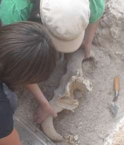
Exposing the cattle skull
In the first segment, we continued to reduce the chalky fills at the base of the ditch. The star find of the day was part of a large cattle skull, lying at the base of a chalky fill deposit, over one of the lower less chalky fills near the base of the feature. Probably an example of a type of wild cattle known as Aurochs (Bos primigenius), which was distributed widely over Europe may also have been domesticated by the time the ring ditch was made. The skull appears to have been tipped in with the fill and its location does not seem particularly significant to the interpretation of the ring ditch.
However it is an interesting find and casts light on the type of animal that occupied the contemporary landscape with the ring ditch builders, and the sort of meat bearing or working animals that might have been used by the community that built the ring ditches that cover this landscape.