Back to Introduction
Display Contents
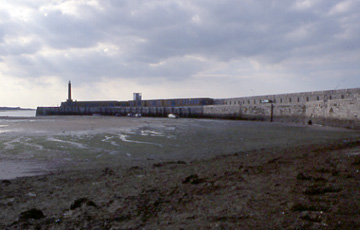
Main Pier
Pier Surface
Jetty Entrance
Stone Fabric of Pier
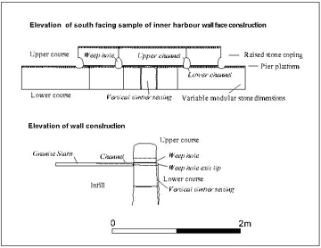
Inner Harbour Wall
Weep holes in Inner Harbour
Beginning of Pier and Sea Defences
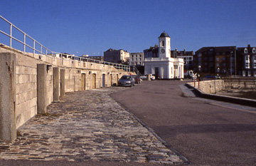
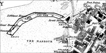
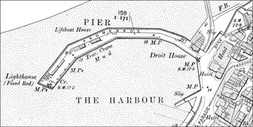
Droit Office
The Promenade
The Promenade Stores
Brick Built Workshops
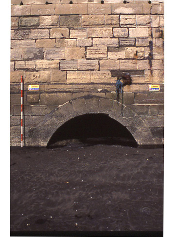
Sluice
The Pier Fittings
Historic Images
1953 Storm Damage
The lower deltaic sandstone used to
build both Margate and Ramsgate piers were quarried from Aislaby, three
miles south west of Whitby in Yorkshire. The stone is resistant to
weathering and was used in major buildings, ports and bridges in London
(White 2004).
A wooden jetty designed by Jarvis for the mooring of Hoys and Steamers was added adjacent to the pier in 1824. This jetty was known as Jarvis' landing stage.
A wooden jetty designed by Jarvis for the mooring of Hoys and Steamers was added adjacent to the pier in 1824. This jetty was known as Jarvis' landing stage.
It has been suggested that the present
pier may have incorporated the remains of the earlier pier within its
fabric. The main structure of the pier has been repaired over the years
where storms and bombs from WWII have caused damage to its structure.
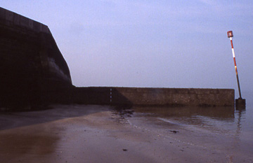
The end of the Pier was undermined by wave attrition during storms in 1953 and collapsed. It was rebuilt in 1954 and additional sea defences were added to the Pier between 1954 and 1959 including the construction of a concrete Groyne on the outer harbour wall.
The end of the Pier was undermined by wave attrition during storms in 1953 and collapsed. It was rebuilt in 1954 and additional sea defences were added to the Pier between 1954 and 1959 including the construction of a concrete Groyne on the outer harbour wall.
Few areas of original surfacing remain on the pier. Historic photographs indicate that the whole lower part of the pier was once surfaced with cobbles. A cobbled area adjacent to the promenade may be a relic of this surface but its present condition suggests that it may have been substantially repaired or could even be an entirely new construction.
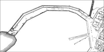
The original pier was modified during 1853-6 to provide an entrance for the newly constructed iron and wooden jetty that replaced Jarvis’ landing stage. The outer harbour wall originally extended to meet land at the beginning of Section 1 of the pier at Bank Side.
The entrance to Jarvis’ landing stage was situated to the east of the Droit Office with a beach slipway between it and land. The new Jetty entrance involved the removal of part of the original harbour wall at the base of the Promenade steps to the west of the Droit Office.
Stone fabric of Pier
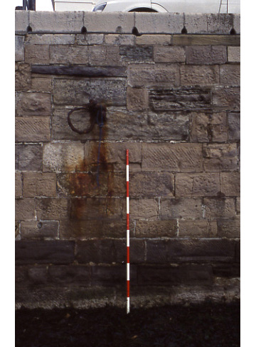
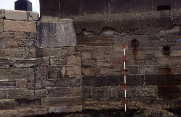
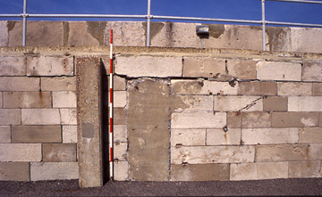
The north face of the pier is formed of coursed ashlar in a variety of styles. Sixteen courses were visible to the level of the sand when surveyed. The lengths and heights of the blocks vary, the largest are 1.6m in length by 0.4m high. The dimensions of the stones may reflect a random distribution of modular unit sizes which may give additional strength to the wall as no weaknesses would be caused by regular matches in jointing. The stones are generally grouped in three to four courses of blocks of equal height.
The north face of the pier is formed of coursed ashlar in a variety of styles. Sixteen courses were visible to the level of the sand when surveyed. The lengths and heights of the blocks vary, the largest are 1.6m in length by 0.4m high. The dimensions of the stones may reflect a random distribution of modular unit sizes which may give additional strength to the wall as no weaknesses would be caused by regular matches in jointing. The stones are generally grouped in three to four courses of blocks of equal height.
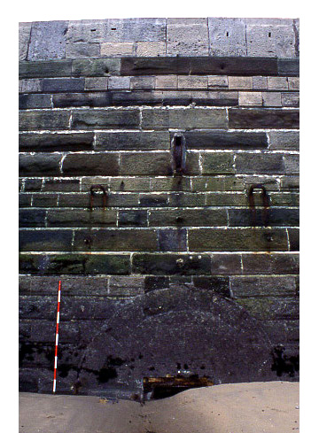
The last three courses at the top of the pier appear irregular and are slightly overhanging; these courses extend above the platform level of the pier and form the back wall of the promenade and its store rooms. The structure is capped with modular sandstone copings forming the edge of the promenade walkway.
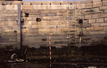
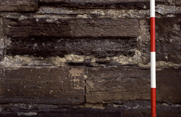
The southern inner harbour wall is revetted with a system of coping stones, the lower of which forms the last course of the harbour wall and the upper single course which are raised above the edge to form a low revetment around the inner harbour. The stones of the upper course are chamfered along the long sides forming rounded edges. Breaks in the wall are finished with a curved terminal stone
The drainage of the pier surface has been facilitated by a system of weep holes formed by channelling the upper and lower stones. The lower part of the ends of the upper stones are cut away to form the upper element of a vent. Where the upper element of the vent is formed the lower coping stone has been channelled with a matching gully to form a roughly pear shaped vent. Some of the granite paving butting the coping stones have been channelled on an ad hoc basis to increase the efficiency of the drainage.
Railings were originally fixed to the coping stones on Section 1 of the inner harbour wall in front of the Droit Office. At the eastern end of the pier these railings were fixed to a large curved quoin stone which marked the beginning of the pier.
Engravings from 1936 show railings connecting to this stone where the Pier adjoined land and extending along Bank Side/The Parade. Photographs from 1870 indicate that the land surface dipped below the level of the pier between the beginning of the pier and the inner harbour slipway. The revetting wall between the pier and the slipway are of a similar construction as the pier suggesting a similar construction date. A photograph from 1889 indicates that this surface was levelled between 1871 and 1889 and topped with railings.
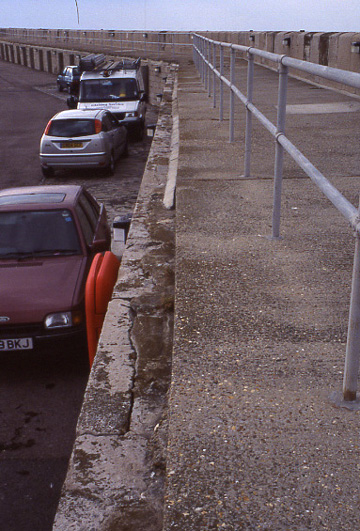
Following storm damage in 1953 cast concrete seats with drainage holes were added the length of Margate sea front from the Pier to Marine Parade to act as an additional sea defence for the road. The quoin, infilling of the land surface and the concrete seats are clearly visible in the existing structure
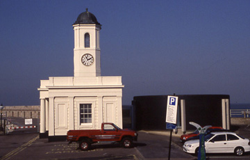
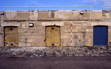
The Droit Office was originally constructed in 1828 as an office for the collection of Harbour dues by the Pier and Harbour Company. Maps, engravings and photographs indicate that the structure was originally rectangular in plan and the rear of the office faced directly to the sea on the outer harbour wall.
The wood and iron jetty constructed between 1853 and 1856 extended to the rear of the Droit office. Extensions were added to the rear of the original Droit Office between 1852 and 1872.
In the 1940’s the Droit Office was destroyed by German bombing and was subsequently rebuilt in 1947 on the original footprint according to the original architects plans. The building extensions to the rear of the Droit Office do not appear to be replaced at this time and a separate rectangular building was constructed on the Jetty entrance.
The current Droit office has an extension to the rear constructed at the end of the 20th Century and now serves as the visitor centre for Turner Contemporary.
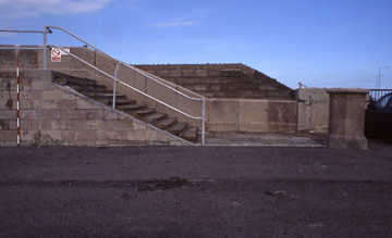
The promenade was accessed by a flight of ten stone steps from the Section 1 of the pier west of the present Droit Office entrance. Originally the Outer Harbour wall continued above the pier surface along to the Droit office until the construction of a wooden and iron jetty replacing Jarvis’ wooden jetty which necessitated the construction of an access point through this segment of the harbour wall
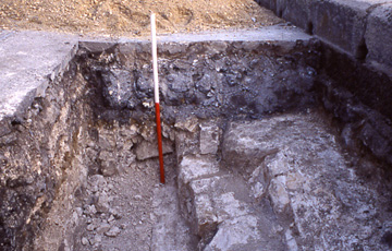
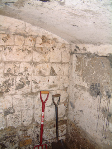
Beneath the promenade platform on Section 2 of the pier are six separate entrances to small rooms and the suggestion of a possible window at the end of Section 3. The rooms were used to store fishing nets and other equipment.
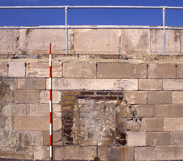
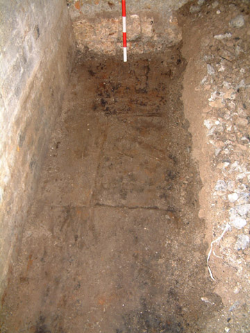
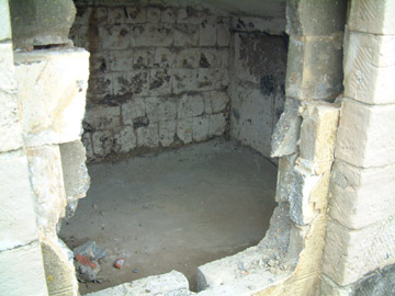
In both store rooms the eastern and western walls had been rendered with concrete and were probably constructed from red brick. The back walls of both store rooms were constructed of eight courses of chalk blocks of varying sizes. The store ceilings was vaulted and had been rendered to a smooth finish.
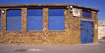
The brick workshops at the beginning of Section 4 of the pier are constructed of yellow stock bricks with reinforced concrete slab roofs and wooden doors. The bricks and concrete slabs have been eroded by sea water.
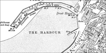
The inner harbour has suffered from silting by mud, detritus and seaweed which creates an unpleasant smelling aroma at low tide. The silting of the harbour seems to be a problem long associated with the pier, mud is labelled on the OS maps of 1896 and 1907 in the inner harbour.
Emma
Boast
Version 1. Posted 24.02.06
Version 1. Posted 24.02.06
All
content © Trust for Thanet Archaeology