Return to Possible Henge monuments of Thanet
Display Contents
Possible Henge monuments of Thanet
Link -
Excavated sites
Summary
?Late Neolithic
Mill Lane Margate
LOM I
LOM IID
LOM III
Date uncertain
LOM V
Bradstow School IV
Mini-Henge?
North Foreland III
Link - Excavated sites

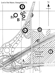
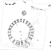
The excavation of Lord of the Manor I in 1976
by the Isle of Thanet Archaeological Unit
(photographer unknown)
Summary
This is a brief exploration of the excavated ring-ditch monuments which may have been
(or
started life as) Late Neolithic ceremonial enclosures, otherwise known
as 'Henges'.
Several show evidence of having more than one phase of activity which demonstrate an Early Bronze Age refurbishment and re-use of an earlier monument.![]()
Several show evidence of having more than one phase of activity which demonstrate an Early Bronze Age refurbishment and re-use of an earlier monument.
Mill Lane Margate: ?
LOM I: 30.0m.
LOM III: 30.0m.
LOM IID: 23.0m.
LOM V: 32.5m.
Bradstow School: 32.73m.
(possibly 34.09m.)
North Foreland: 10.5m.
Causeways
Mill Lane Margate: Yes (1)
LOM I: No
LOM III: Yes (1)
LOM IID: Yes (1)
LOM V: Probably (1)
Bradstow School: Yes (1)
North Foreland: Yes (1)
External bank evidence
Mill Lane Margate: ?
LOM I: No
LOM III: No
LOM IID: No
LOM V: No
Bradstow School: No
North Foreland: No
Internal bank evidence
Mill Lane Margate: ?
LOM I: No
LOM III: No
LOM IID: Yes
LOM V: No
Bradstow School: No
North Foreland: No
Ditch recut
Mill Lane Margate: ?
LOM I: Yes
LOM III: Yes
LOM IID: No
LOM V: Yes
Bradstow School: No
North Foreland: No
Pits and post-holes
Mill Lane Margate: ?
LOM I: No
LOM III: Yes
LOM IID: Yes
LOM V: No
Bradstow School: Yes
North Foreland: Yes
Burials/Contemporary (ie. no significant time lapse)
Mill Lane Margate: Yes/?
LOM I: Yes/No
LOM III: Yes/No
LOM IID: Yes/No?
LOM V: Yes/No
Bradstow School: No
North Foreland: Yes/?
All except the Lord of the Manor I monument have a causeway (though a cut-down causeway would have been invisible on the surface and could have been present, as at Bradstow School IV). All appear to have employed a single causeway only. Dimensions and orientations vary.
All except LOM IID are over 30m in diameter and have few internal features aside from graves. None of these graves can be considered as certainly contemporary with the founding of the monument however. Only Bradstow School IV failed to produce any in-situ human graves. Of particular interest perhaps is the skull recovered from the bottom of the ditch at LOM III (but see below) and the disarticulated multiple burial from LOM V (accompanied by an animal grave), types of deposits which could be reflecting Neolithic traditions perhaps.
As far as other types of features (in the 30m monuments) are concerned these are only found at LOM III and Bradstow School IV. In both these cases the features comprise largely unproductive and undateable pits.
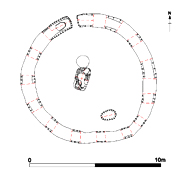
At 23m in diameter LOM IID is the smallest of the more conventionally sized 'Henge' monuments, but contains the most interesting and varied series of internal features, including the post-holes of a wooden pentagonal structure (see below).
A small Causewayed roundbarrow discovered at the site of the former St. Stephen's College, North Foreland (North Foreland III) also contained some interesting (but undateable) internal features and could potentially represent an example of a Mini-Henge or Hengi-Form monument. It was 10m in diameter and contained three inhumation burials, one of which was cut into the base of the ditch near the causeway and capped by a piece of whalebone.
The other internal features included a couple of small shallow pits and post-holes, the most interesting of which was a circular pit packed with small nodules of burnt flint, capped by larger tabular slabs of flint and non-local sandstone. The relationship between the pit, the burials and the rest of the monument is not clear. There are few stratigraphic relationships and this monument is undated at present.
Whether any of the Causewayed ring-ditch monuments described here can be thought of as representing a Henge or Mini-Henge depends on the parameters for the definition of such a monument. The classic definition of a causewayed ditch with an outer bank would apply to none of Thanet's known excavated sites (though Mill Lane is an unknown quantity at present).
Much variation exists in the nature of Henges countrywide and it is quite possible that the individuals who constructed Thanet's potential Henge or Hengi-Form monuments might have done so according to their own designs/local traditions. Comparisons are useful and informative but we should also be careful of relying too heavily on well published examples from other parts of the Country which may have little relevance to the situation here. Ultimately the true function and place of Henges in Late Neolithic, Beaker and Early Bronze Age society can only be guessed at and much waits to be discovered!
Outer ditch
Diameter: ?
Width top: ?
Width base: ?
Depth: ?
Recut: ?
Inner ditch
Diameter: ?
Width top: ?
Width base: ?
Depth: ?
Recut: Yes
Causeways: 1 (Outer ditch)
Causeway orientation: ?
Causeway width: ?
Causeway slighted: ?
Orientation: ?
Height: ?
Rescue Excavation instigated and
conducted by John Villette, assisted by the Kent Archaeological Rescue
Unit.
Part
of a Causewayed ring-ditch
monument seems to have been encountered during the construction of the
multi-storey car park in Margate. Overall the monument comprised
two
ditches, with the outer one having a causeway. The inner ditch
(possibly shallow) had apparently been backfilled with chalk and
subsequently re-cut. At the centre of the monument were 'radiating
slots' (not deep) which may have represented the base of a Post-Mill.
A grave containing a crouched inhumation
burial was found cut into the surface
of the causeway. The grave also produced finger-tip decorated pottery
which may have been Mid/Late Neolithic Peterborough Ware.
Similar sherds of an 'incomplete pot' of apparent Peterborough Ware were also found in the fill of the terminus of the outer ditch (at the point of the causeway, by the burial).
On current evidence this monument could have been a Late Neolithic Henge. The grave could represent either a foundation deposit or perhaps a blocking deposit.
NGR 635435 170622.
John Villette pers comm.
Mynot 1975.
Outer ditch
Diameter: 30.0m.
Width top: 3.0m.
Width base: ?
Depth: 1.5m.
Recut: Yes
Inner ditch
Diameter: 12m.
Width top: 1.5m.
Width base: ?
Depth: 0.8m.
Recut: No
Middle ditch
Diameter: 19m.
Width top: 2.0m.
Width base: ?
Depth: 0.57-1.3m.
Recut: No
Causeways: 1 (Middle ditch)
Causeway orientation: SE
Causeway width: 8.5m.
Causeway slighted: Yes
Orientation: SW facing slope
Height: 41m OD.
(TAU)
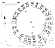
Excavation led by Nigel
Macpherson Grant, Thanet Archaeological Unit; (LOM I).
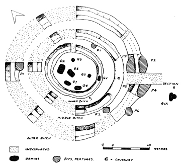
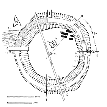
A Four-Phase triple
ring-ditch monument.
Phase 1
(Later Neolithic?): the large outer ditch was dug
first and allowed to infill, perhaps after a period of abandonment.
There was no evidence for a causeway.
Phase 2
(Beaker, circa
1950-1850 BC): the
infilled outer ditch was subsequently re-cut during the Beaker
Period.
Pit F1 was also dug. A single inhumation burial (1A) beyond the outer
ditch,
contained within a chalk 'cocoon' likely belongs to this phase.
Phase 3
(possibly circa 1800-1750 BC): The re-cut outer
ditch began to
infill again and then a
rectangular
grave (G5) and the inner
ditch (a roundbarrow) was dug. The grave contained the crouched
inhumation burials interpreted as that of a 'father and daughter'.
No clearly dateable
finds.
(TAU)
Phase 4
(possibly circa 1700-1500 BC): Once the inner ditch
was
half filled the middle ditch was constructed with
a causeway to the south-east. Six burials comprising one cremation
(G6, a cord-decorated pot, possibly a Food Vessel, containing the ashes
of a baby and accompanied with a barbed and tanged flint arrowhead) and
five
single crouched
inhumations (G1-4 and 7) were deposited.
Finally the causeway was 'blocked' by the digging of a trench
across it.
Disarticulated human bone was recovered
from both the lower and upper
fills of all three ditches with the exception of the upper fill of the
final, middle ditch. Carved chalk objects were recovered from the
primary
silts of the inner ditch (a 'cup/lamp'), the middle ditch (a
'cup/lamp' and two blocks with criss-cross carvings) and the outer
ditch (a 'cup/lamp').
Ges Moody (pers comm.) has recently noted that
this site lies within a slight dip in the landscape. Building a
monument in a more 'hidden' or private location seems to echo a trend
that has been seen in the siting of some Earlier Neolithic monuments
elsewhere in the Country. This trend was subsequently reversed when
generally more prominant and highly visible sites were selected as
locations for the construction of roundbarrows. A reason behind this
could lie in the differences between the functions of these two
monument classes.
A comparison of the differences (if any) of the locations for the roundbarrows and the potential Henge monuments on Thanet is the next task (watch this space).
A comparison of the differences (if any) of the locations for the roundbarrows and the potential Henge monuments on Thanet is the next task (watch this space).
NGR 635507 165430.
Fisk 2003. Macpherson Grant 1977.
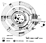
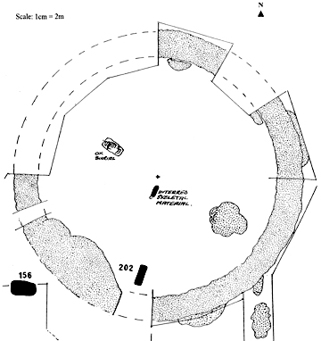
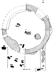
Diameter: 22.0-23.0m.
Width top: 2.0-4.0m.
Width base: 0.3-2.0m.
Depth: 1.20-1.60m.
Recut: No
Causeways: 1
Causeway orientation: SW
Causeway width: 5.80m.
Causeway slighted: No
Orientation: SW facing slope
Height: 39m OD.

(TAU)
Excavation led by Nigel Macpherson
Grant and David Perkins, Thanet Archaeological Unit; (LOM IID).
It is not certain if there was a significant timelapse between the cutting of the ditch (Phase 1) and the creation of the internal features (Phase 2A). A later central crouched inhumation burial covers one of the post-holes and may be associated with a renewal of the post-hole structure.
Phase One (Late Neolithic?): the causewayed enclosure ditch was excavated, with the spoil forming an inner bank. Slots were cut into the bottom of the ditch, but possibly not completed. Evidence of an episode of tree clearance may also belong to this phase. Considerable quantites of densely patinated worked flints (similar to those recovered from LOM I) were recovered.
(TAU)
Phase
2A (circa 1950-1800 BC): this may have seen
the construction of the rammed chalk floor, flint bank, hearth and
post-hole structures. A few sherds of undecorated pottery which overlay
the hearth are similar to the Beaker sherds of LOM I Phase 2.
Phase
2B (circa 1950-1850 BC): Some of the posts of
the timber structure were renewed. The various intenal pits could have
been dug at this time.
Phase 3
(?): A
rectangular grave containing a single crouched inhumation burial was
cut close to the centre of the monument, sealing one of the Phase 2A
post-holes.
NGR 635463 165370.
Fisk 2003; Macpherson Grant 1980.
Diameter: 30.0m.
Width top: 3.0-5.5m.
Width base: 1.0-2.0m.
Depth: 1.70m
(max 1.56m below chalk ?)
(max 1.85m.+ topsoil)
Recut: Yes
Causeways: 1
Causeway orientation: S
Causeway width: 4.0m / 0.6m.
Causeway slighted: Yes
Orientation: SW facing slope
Height: 39m OD.
(TAU)
Excavation led by Nigel Macpherson Grant
and David Perkins, Thanet Archaeological Unit; (LOM III).
A
single ring-ditch monument with a
causeway to the
south. A subsequent Early Bronze Age cremation burial (at its time the
seventh to be discovered in Kent; Dr. I.H. Longworth in Perkins 1980)
and later
Anglo-Saxon graves were cut within the monument.
The skull of small-headed female (about
12-15 years old and possibly a
dwarf)
was found on the base
of the ditch to the east. The skull had a boar’s rib placed through
the foramen magnum at the
back of her head (Macpherson Grant). It is not certain at present
whether this act of ritual deposition is related to the original or
later Early Bronze Age phase of use of the monument (one might suspect
the former).
Phase 1
(Late Neolithic, circa 2000 BC): the circular ditch with a
causewayed entrance was constructed. Two pits (F7 and 8; containing a
few flints and fragments of animal bone and charcoal) were probably dug
at this time. The floor of the ditch on either
side of the causeway was deepened and then the causeway was narrowed
drastically. The site is abandoned and the ditches began to infill
(rapidly at first).

(TAU)
Phase 2
(circa 1400 BC): the part-infilled ditch
was recut intermittently, both internally
and externally,
possibly to provide material for a central mound which covered a
Collared Urn cremation burial (B2). The
inverted urn had been placed in the middle of a pit upon a small heap
of flints. Subsequent
infilling of the recut ditch proceeds slowly.
Phase 3 (Late Iron Age 'Belgic'): Iron Age ploughing speeds the rate of infilling of the ditches. A 'Belgic' coin was found on the chalk surface adjacent to the plough marks.
Phase 4 (circa 6-8th C AD): later Anglo-Saxon burials cut into the edge of an extant barrow mound. They also disturb one of the internal Prehistoric pits (F1).
The final destruction of the mound probably occurred in the Mid 19th century.
NGR 635525 165288.
Fisk 2003; Perkins 1980.
Diameter: 32.5m.
Width top: 3.0m.
Width base: 1.0m.
Depth: 1.6m.
Recut: Yes
Causeways: 1 possible
Causeway orientation: (?) NW
Causeway width: ?
Causeway slighted: ?
Orientation: SW facing slope
Height: 40m OD.
(TAU)
(TAU)
Excavation led by David Perkins; Thanet
Archaeological Unit (LOM V).
Single ring-ditch monument, possibly with a causeway in the unexcavated portion of the ditch. Two similar monuments nearby have a causeway in alignment with this unexcavated portion. Aerial photographs also suggest the presence of a causeway.
Phase 1 (?): the circular enclosure was constructed and subsequently abandoned.
Phase 2 (?): the infilled ditch was re-excavated with recuts spaced alternately on the inside and outside. This was possibly to provide material for a central mound. Slots were also cut into the base of the ditch.
Phase 3 (?): a central 'ossuary' pit was dug and filled with the selected remains of five individuals. The angle of the pit suggests that a mound may have been present. To the west was the burial of an ox, orientated at right angles to the central burial. It is not certain where this particular burial features in the sequence of events.
Phase 4
(Anglo-Saxon): subsequent Anglo- Saxon burials were cut to the
south and south-west of the monument, with only one (surviving) being
within the bounds of the ring-ditch.
NGR 635601 165292.
Fisk 2003.
Diameter: 31.36-32.73m.
(possibly to 34.09m.)
Width top: 3.40-5.10m.
(possibly to 6.78m.)
Width base: 0.95-1.26m.
Depth: 1.50-1.72m.
(possibly 1.80m.)
Recut: No
Causeways: 1
Causeway orientation: WNW
Causeway width: 0.55m.
Causeway slighted: Probably
Orientation: SE facing slope
Height: 42m OD.

Copyright
Archaeology South East
Reprodued from the KAS newsletter (D.Hart 2006)
Evaluation led by Ges Moody of the Trust
for Thanet Archaeology; (BSD06). Excavation led by Diccon Hart of
Archaeology
South East; (DPB06).
A large, single ring-ditch monument with
a small, narrow causeway (0.55m wide) to
the west. The diameter of the ring-ditch ranged from approximately
31.36m-32.73m (D.Hart 2006),
though in an area adjacent to some later quarry pits it reached a
maximum of 34.09m. Here the monument featured a broad, shallow outer
edge beyond the steep
ditch-cut; one that may have resulted from the later pit-cutting
episode, though it that hardly qualifies as a pit and its purpose in
this sense
is unclear.
The surface of the causeway had been cut 0.55m below the level of the natural chalk. It would seem likely that the original causeway was 'slighted', being cut down and narrowed at its surface (leaving a rounded and somewhat precarious track into the centre of the monument) as an act of blocking and closure once it went out of use. Evidence from the sections may be inconclusive in this regard however.
Several (relatively small and shallow) rectangular and oval pits were discovered in the interior; a rectangular pit lay at the centre. No burials or finds of any significance were discovered.
Copyright
Archaeology South East
Reprodued from the KAS newsletter (D.Hart 2006)
Though this monument
has been referred to as a 'large Bronze Age round
barrow' (D.Hart 2006) and may have had a barrow phase (the burial evidence of which may
be largely lost to us) there is also a possibility that it may have
started life as a late Neolithic ceremonial enclosure or Henge.
The large dimensions of this feature may add weight to such an interpretation. It is the largest single and largest Causewayed ring-ditch monument excavated so far on Thanet. Only the double ring-ditched Monkton-Minster III is larger (at 35m in diameter; Fisk 2003). The ditch-depth is likely the deepest yet recorded on Thanet, while the ditch-width may be second only to LOM III (and at its potential full extent is the largest). As a whole the monument is comparable to LOM III, which likely founded in the Late Neolithic.
The Bradstow monument may also have provided a focus for the three certain (and possibly four) roundbarrows which were constructed to the north and north-east.
The information presented
here will be reviewed and updated when a report on the excavations by
Diccon Hart is
published by ASE. This will
also permit the posting of a page giving a more detailed review (with
many photographs) on this interesting site.
NGR 639399 167038.
The dimensions of the
ditch are derived from measurements taken by
the author
during ASE's excavation. This was done with the kind permission of
Diccon Hart. The maximum diameter
of the monument has been measured from a site plan published in the
KAS Newsletter (D. Hart
2006).
The opinions presented are my own and must not be thought the considered, published opinions of Archaeology South East (report forthcoming). I would like to thank Diccon Hart for allowing me to take measurements and photographs of this monument. I hope to update and present a more pictorial piece on this feature once the initial report is published.
The opinions presented are my own and must not be thought the considered, published opinions of Archaeology South East (report forthcoming). I would like to thank Diccon Hart for allowing me to take measurements and photographs of this monument. I hope to update and present a more pictorial piece on this feature once the initial report is published.
Plan - D.Hart 2006.
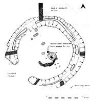
Diameter: 10.0m-10.50m.
Width top: 0.78-1.03m.
Width base: 0.57-0.81m.
Depth: 0.36-0.53m.
Recut: No
Causeways: 1
Causeway orientation: NNE
Causeway width: 0.40m
Causeway slighted: No
Orientation: NW facing ridge
Height: 40m OD.
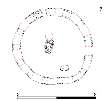
The Causewayed barrow is to the left of the scale
A single ring-ditch monument with a narrow causeway (0.40m wide) to the north. Within the roundbarrow were two graves (one central; one to the south-east) and a pit, while a third grave was cut into the bottom of the ditch to the west of the causeway.
Both internal graves were shallow and poorly preserved. The rectangular central burial held the remains of an adult, laid on their left-hand side with the head to the south, facing west. The individual may have been laid within a coffin-structure. To the south-east of the first grave lay the even more poorly preserved burial of an individual laid within an oval grave.
(TTA)
Immediately to the west of the central
burial was a round pit which had
been
filled with small nodules of burnt flint and capped by large slabs of
tabular flint and sandstone (possibly non-local Greensand/Ragstone).
This feature seems to represent an act of purposeful deposition and
could have been connected with rituals associated the central burial or
the founding of the monument. The relationship between the flint pit
and the central burial is unclear, but it may be that the grave-cut
respects the pit and thus could be later.
Cut into the bottom of the ditch, close to the causeway, was the well preserved grave of a small child. A large fragment of whale bone had been laid across the surface of south-eastern side of the grave.
Cut into the bottom of the ditch, close to the causeway, was the well preserved grave of a small child. A large fragment of whale bone had been laid across the surface of south-eastern side of the grave.
NGR
639700
169252.
Boast, Gardner and Moody 2006; Fisk 2003.
Boast, Gardner and Moody 2006; Fisk 2003.
ASE - Archaeology South East.
TAU - Thanet Archaeological Unit.
TTA - Trust for Thanet Archaeology.

(Fisk 2006)
Particular thanks goes to Pip Fisk for her work on compiling a thorough, comprehensive and invaluable gazetteer on the ring-ditch and roundbarrow monuments excavated on Thanet (Fisk 2003). The time which has been saved by consulting this document is immeasureable and it has had a profound impact on the labour taken to make the observations and presentations of the potential Henge monuments published here.
I would also like to thank Thanet Trust's Director Emma Boast for the reproduction of the plans from the excavations at North Foreland.
Version 1 - Posted 26.09.06
Version 2 - Posted 16.12.06
All
content © Trust for Thanet Archaeology