Gallery Guide
Medieval Thanet
Standing Buildings
Ports
Land Reclamation
Markets
Medieval Thanet
In the period after the Norman conquest
Thanet's medieval character was established as an area heavily
controlled and influenced by the Church. Within the geopolitical
divisions that are recorded in the Domesday Book Thanet encompasses a
single unit; the Hundred of Ringslow within the Borough Lathe.

Churches and other assets such as salt houses, piggeries and woodlands are also listed. Margate is mentioned in reference to the Chislet estate of St Augustine's which held 6 sulungs and 4 saltpans there (Quested 2001 p.18). With the reorganisation of the lathes in the 13th Century, Thanet was incorporated into the Lathe of St Augustine's (Lawson 2004a).
Monkton was a Manor of Christ Church Priory, Canterbury, Minster was a Manor of St Augustine's Abbey (Sweetingburgh 2004). The monks of Christchurch Priory owned the Manor of Monkton and the manor of Brooksend. The Monks of St Augustine owned the Manor of Minster and directly held land at Hengreve (?Hengrove Farm), Salmanston (Salmestone), Newlond (Newlands Farm), Aldelond (Alland Grange) and Caleys (Callis Court); and claimed rights over other manors at Thorne, Pegwell, Nash Court, Ozengell Grange and Manston Court (Quested 2001 p22).
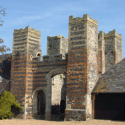
Standing Buildings
A number of standing buildings dating from the medieval period; some with earlier origins, still stand on the Isle of Thanet. The churches of St Lawrence, Ramsgate; St Peters, Broadstairs; St Johns, Margate and St Mary's Minster all incorporate medieval fabric. Archaeological excavation has confirmed the existence of three other medieval churches; All Saints, Shuart; St Giles, Sarre and St Mary Magdalene at Woodchurch.
Other standing medieval structures include Monastic Granges at Salmestone and Minster, a tithe barn at Ozengell, Ramsgate; and the gateway of the medieval manor of Dent-de-Lion (Daundelyon) at Garlinge where there is an example of the early use of brick in its structure (Lawson 2004b) and the defensive late Medieval York Gate in Broadstairs. Other evidence of domestic medieval buildings exist across the island concealed within later structures such as roof timbers at Netherhale Farm, Birchington.

Five ports on the Isle of Thanet were ‘limbs’ of ports within the Confederation of the Cinque Ports which was established by the 1150's. Four of the Cinque Ports were located in Kent - Dover, Hythe, New Romney and Sandwich in strategic positions able to defend the coast. The Cinque ports were required to provide ships and crews for the Kings service and in return they received constitutional, financial and trading privileges.
Birchington - Gore End (by 1373), the fishing village of Margate (by 1293) and Broadstairs- St Peters and Broadstairs small haven (by 1424) became limbs of the Port of Dover. Sarre and Ramsgate were limbs of the Port of Sandwich by 1353 (Lawson 2004c; Quested 2001 p38).
Land Reclamation
Reclamation of land and natural processes of silting lead to the inning of the Wantsum channel and at the end of the Medieval period that the Wantsum channel ceased to be navigable by large craft. Land reclamation took place all along the Thanet coastline during the 13th century from Brooksend to Sarre where it was carried out apparently by individual tenants but in the Minster to Monkton area the work was carried out predominantly by the monks.
'Walls’ such as the Abbott’s wall in the Minster marshes and the Monk’s Wall north west of Stonar were constructed of earth possibly heaped around hurdles and bundles of straw. Archaeological excavations have indicated that the Monks Wall comprised a bank approximately 8 m wide with a parallel inner ditch approximately 5.5 m wide, cut to drain surface water. The bank stood to a height of 1.75 m from the alluvial surface on which it had been laid (Perkins 1998).These defences were constructed to enclose areas of land from the sea to develop for agricultural and pastoral use (Quested 2001 p28).
This work created conflict between the men of Sandwich and Stonar and the Abbott of St Augustine as the towns people believed that the Abbott's work led to the silting of the Sandwich Haven preventing large ships using the port at Sandwich. The Abbot of St Augustine commenced legal action against the people of Sandwich in 1280 for vandalism of a sea defence wall (the Monk’s Wall) that the Abbot had constructed (Boys 1792, 660). They
"...weakened the sea wall between Stonar and Cliffsend by carrying away stones, and they invaded the Abbott's marsh between Stonar and Ebbsfleet and carried away soil for filling up and repairing their quays at Sandwich"
(Sparkes: 7).
In the 13th and 14th Centuries local markets played a role in the economy of Kent. Population growth and the ambitions of local landowners gradually reduced the amount of land available for peasants to grow enough and raise stock to support themselves. Combined with the growth of specialised crafts in both towns and rural areas people became dependent on purchasing food and other items from markets. Documentary sources have identify four areas where Markets were held on Thanet; Broadstairs, Stanores (probably Staner Hill, Ramsgate), St Nicholas at Wade and Minster in Thanet (Lawson 2004d). Much of the network of roads and lanes that exist today were created to connect villages, ports and markets that were central to medieval life.
Birch, D., Boakes,.et al. 1987. The Gateway Island. 2nd Edition. Thanet District Council.
Lawson, T. 2004a The Revised lathes and Hundreds in Lawson & Killingray 2004. p59.
Lawson, T. 2004b Greater and Lesser Houses pre-1500 in Lawson & Killingray 2004 p64.
Lawson, T. 2004c The Cinque Ports in Lawson & Killingray 2004 p52.
Lawson, T. 2004d Markets in the Medieval Period in Lawson & Killingray 2004. p50
Lawson, T. & Killingray, D (eds). 2004. An Historical Atlas of Kent. Phillimore.
Perkins, D. R. J 1998 The Monk’s Wall, Sandwich. An Archaeological Investigation Report Trust for Thanet Archaeology unpublished.
Sparkes, M. Undated. Stonar, a Documentary History.
Sweetingburgh, S. 2004. Landholding in 1300 in Lawson & Killingray 2004. pp 48-49.
Quested, R. K. I., 2001. The Isle of Thanet Farming Community. 2nd Edition. Intype London.
Version 1 - posted 14.05.06
The Misericords: St Mary the Virgin, Minster
All
content © Trust for Thanet Archaeology