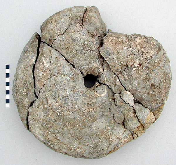
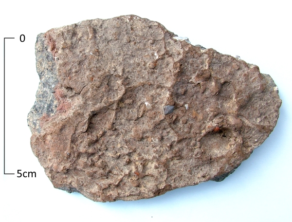
Iron Age quern (150-50 BC) found at North Foreland, Broadstairs. Reconstructed from 11 pieces, c 320mm diameter.
While prehistoric periods are often separated by innovations in the technology of cutting tools, from flints through to copper, bronze and iron implements, one technology seems to link all these periods and to extend nearly to the limits of our own living memory.
For many thousands of years hand grinding of cereals and grains were essential to processing the fruits of agricultural labour into the the food that sustained life each day. In much of the developing world hand querns, mills and grindstones remain an essential part of daily life.
While much of society was devising new and innovative ways of chopping down trees, cutting raw materials and taking a swipe at each other with the latest materials, somebody somewhere was grinding out flour with a rubbing stone, a rotary quern or hand mill. The application of animal, water or steam power eventually scaled up the process, but somewhere in the mechanism remained the grinding surfaces between two stones.
On many sites, whatever the prevailing ‘… Age’ indicated by the pottery, grain processing and storage are the predominant finds, suggesting that what unites the developing history of Britain is one long Grain Age.
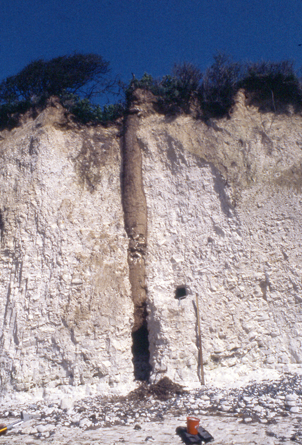
If you are out and about on Thanet’s beaches this coming Bank Holiday, or, come to that, any time of year, keep an eye out for features such as this appearing in our chalk cliffs or in the wave cut shelf on the beach.
This medieval well shaft was exposed at Cliffsend in 1985 following a chalk fall and recorded by the Isle of Thanet Archaeological Unit. Over the years Iron Age features, including pits and ditches, have been recorded at Dumpton Gap and prehistoric, Roman and Medieval features in the bays between Westgate and Birchington. The bases of Roman well shafts have also been recorded on the beach at Reculver.
So, keep your eyes peeled because you may spot a piece of Thanet’s Archaeological heritage on one of your seaside walks.
P.S. Please remember that cliffs can be dangerous and keep an eye on those tides while you are out and about.
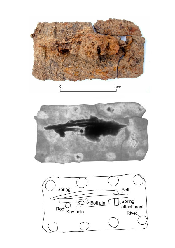
Iron lock mechanism from an Anglo-Saxon site in Westgate, Thanet
Our image for VM_365 Day 51 is of a find from an excavation carried out on the site of a housing development close to the sea front at Westgate on Sea in 2006. This composite iron object was found among features that represent a phase of a settlement which seems to date to the 8th or 9th century AD. Another of the few Viking age sites known in Thanet.
This complex iron block which was recovered from the fill of one of the pits appears to have been a lock mechanism, perhaps originally attached to a box or chest. The mechanism has been reconstructed from the evidence of several X-ray photographs taken at varying intensities which revealed the hidden structure on the back of the plate.
The 2-3mm thick flat iron plate would have been mounted on the external surface of the chest with two rows of four iron rivets or nails arranged along each of the long axes. The front of the plate was pierced with an irregular key hole, centrally placed on the short axis but offset slightly on the long axis.
An iron spring with a right-angled bend was attached to the inside face of the plate. A sliding bolt rested on a rod that projected from the plate, held in place by the spring bearing down on the bolt where it pressed against the rod. The bar appears to have passed through a slot in the spring at a point above the attachment where the spring was fixed to the plate. The bolt would probably have projected a little further, fitting into a socket or staple fitted in the box.
The lock would have been operated by pushing a simple key through the hole in the plate. The key pushed against the bolt pin located on the underside of the sliding bolt at the end of the keyhole forcing the bolt away from the socket which held the box shut. In its present state the mechanism appears to be in the locked position and sliding the bar would need a little force to lift the spring where it was bearing down on the rod.
Lock fittings and keys are a common find on both Roman and Anglo-Saxon sites and the common discovery of bunches of keys in Anglo-Saxon female graves are interpreted as a symbols of female domestic authority, as holders of the keys to a household chest where the valuable items were kept.
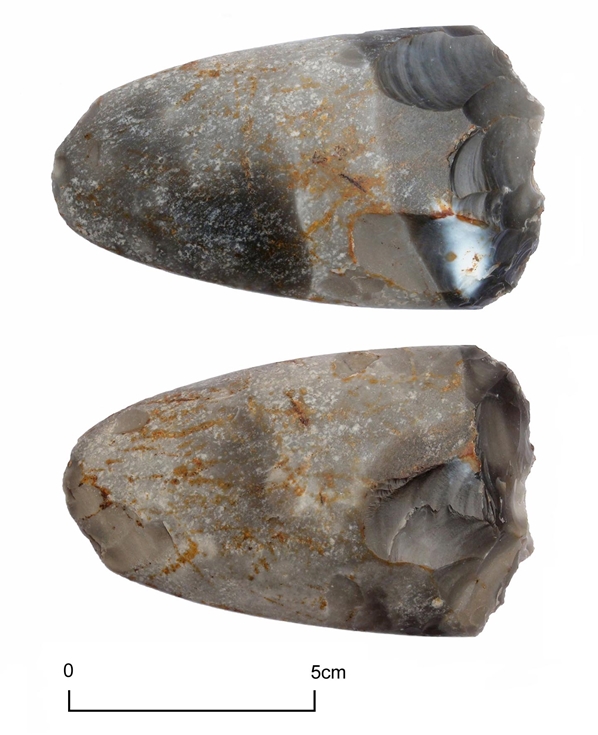
Today’s image is of a late Neolithic polished flint axe found during fieldwalking at Woodchurch, Birchington in 2011.
This polished axe may originally have been intended as a status symbol or for ceremonial purposes and it would have taken many hours of polishing to achieve the beautifully smooth surface. On being broken, the ends have been reworked to become a useful hand tool.
Other examples of polished axes found on Thanet can be seen in the Neolithic gallery of the Virtual Musuem.
Early Iron Age pottery sherds from South Dumpton Down with rusticated surface treatment
The bizarre effects of a surface treatment that as applied to some pottery in the Early Iron Age (600 – 400BC) are illustrated in todays VM_365 image of a sherd from the Iron Age settlement at South Dumpton Down, Broadstairs.
Additional clay was added to the surface of the pots while they were being made, which was wet enough for the potters hands to raise these irrregular lumps and bumps on the outside of the vessels. Sometimes broad wiping marks or and other visble signs of the potters hands can be detected in the surface pattern.
It is not known why this process was applied to certain vessels, but it is thought it may have made the vessels easier to grip if they were perhaps used in activities that would otherwise have made the surfaces slippery. A suite of vessels has been identified in east Kent which have had this ‘rustication’ effect applied to their surfaces, examples are also known from the continent.
The method of roughening the surfaces of the vessels was commonly used in the early Iron Age period but the technique may have lasted in the potters repertiore into the later Iron Age, although used less frequently and without producing the exaggerated roughening that is commonly found on the earlier vessels.
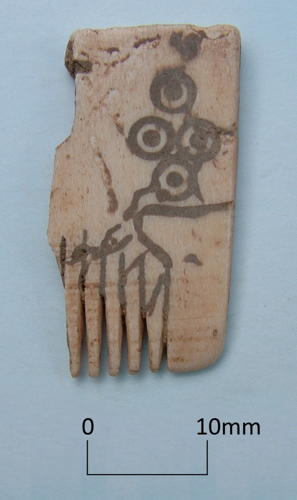
Today’s image shows a fragment of a comb carved from a piece of ivory. The surface is inscribed with curving lines and a dot and circle pattern and was found in an 8th to 9th century refuse pit at Cliffsend in 1998.
Comparable combs have been associated with the Viking period of the 8th-9th centuries and although Thanet is mentioned in historical records of Viking raiding, we have few archaeological finds from the period.
In the same pit, along with pottery and other objects, was the skeleton of a Cod estimated to have weighed about 18 kilogrammes (40lb) which tells us something about the contemporary economy and ecology of the 8th-9th century.
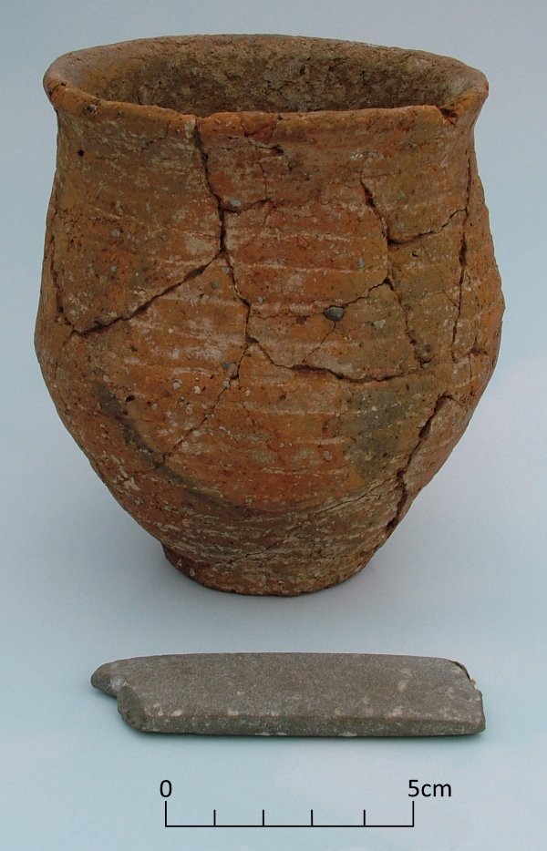
Today’s image is of a stone archer’s wristguard accompanying a Beaker vessel found in an Early Bronze Age round barrow at St Peters, Broadstairs.
The wristguard, made from non local mudstone, and Beaker were found in excavations at the St Peter’s Refuse tip site between 1969-1971 where an important Anglo Saxon cemetery was also excavated.
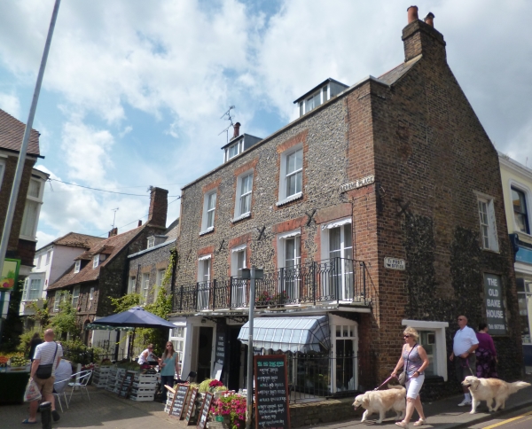
This very attractive historic little corner situated just off Broadstairs High Street is Serene Place and the buildings within it date from the 17th to the early to mid 19th century.
The Serene House, the second building from the left is the earliest in the group and seems to have originally been constructed around 1603, probably as a timber framed building. It was refronted in the 18th century when it was faced with flint with red brick dressings. The building has a beamed interior and an inglenook fireplace.
Bradstow House, the building on the corner of Serene Place and the High Street, is early 18th century and was originally constructed as a single house but is now a house and the Old Bake House and cafe. The shop front that you can see was constructed in the 19th century.
Castle House, first from the left, and Lancaster House, third from the left are both Georgian. Castle House, built in the early 19th century is a three storey brick building with a basement. Lancaster House, a 2 storey townhouse faced in flint, was built in 1824 for Samuel Lancaster after whom it was named.
The tithe map of Saint Peter published in 1842 shows these houses facing onto an open area of land. After 1842 this was infilled with a terrace of houses facing Serene Place named Raglan Place. Only 3-5 Raglan Place survive of this early 19th century terrace.
The flint lined cellar cut into chalk hillside overlooking Viking Bay
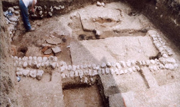
Before the building at Stone Road that featured in yesterday’s VM 365 post was discovered, there were few confirmed archaeological sites of Roman date in the Broadstairs area. Only a few years later, in 2009, a second building was discovered, on the south facing slope of the chalk ridge that forms the northern side of Viking Bay. The site was adjacent to the historic Fort House, which stands on the crest of the promontory overlooking the sea to the east. In the mid 19th century Charles Dickens and his family rented Fort House on several occasions for extended stays, from where it derives its current name of Bleak House.
On the site of a new house which was to be partly terraced into the chalk slope, a number of large soil filled features were found cutting into the surface of the solid chalk geology. The whole site had been heavily truncated by terracing to form platforms for gardens and at one time an orchard.
Excavation revealed that the the pits were in fact large cellars which had been excavated below buildings that once stood on the surface of the chalk, although nothing of these surface structure remained to be recorded. Although two of the cellars seem probably to have been lined with timbers, one had a flat ledge cut around two sides which supported several surviving courses of large water rolled flints, occasionally interspersed with thick flat sherds of Roman amphora.
The wall shown on left side of the image was divided into two sections by a huge nodular flint, which may have supported a post of the structure above. The upper levels of the wall had been destroyed and robbed of its stone, part of the wall had been removed by an engineering test trench excavated before the archaeological investigation began.
Although there had been a great deal of damage to whatever Roman building once stood here, some complex sequences of deposits survived to show that the history of the building was complex and once again hinted at a more complicated story that may not be possible to reconstruct in detail. Almost all the finds associated with the structure were found in the fill of a ditch that had been cut through a gritty sand deposit which had filled the void of the cellar.
Some of these finds will be explored in later VM 365 posts.
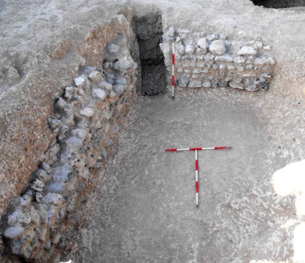
Basement room, almost all that survived of a Roman Villa at Stone Road, Broadstairs.
The North Foreland promontory is separated from the downland slopes further to the south by a dry valley, which falls to the cliff line near Stone Bay. In recent time a cutting was made through the cliffs, forming steps and a steep ramp to reach the present shore. In the Roman period there may have been a more gentle slope through the base of the valley, leading to a natural bay located further to the east, which has since been destroyed by coastal erosion.
In the 1920’s O.G.S, Crawford, the great pioneer of British archaeological survey, noted that earthworks and Roman pottery had been found on patch of open downland at Stone Gap , to the north of Broadstairs. No further investigation of the site seems to have taken place before the growing suburbs of Broadstairs eventually enclosed the location within the garden of a bungalow. No attention was drawn to the record of the Roman finds made by Crawford again.
In 2004, the large garden of the bungalow was divided and part was sold to be the location of a new house, to fronting Bishop’s Avenue near its junction with Stone Road. In an archaeological evaluation trench on the site a few scraps of painted plaster were found, with a few Roman and late Iron Age pottery sherds, along with a row of rounded flint cobbles which appeared to be part of a wall. A larger area excavation had to be carried out, which was not an easy task in the very limited space.
Below the deep layer of garden soil that had been distributed over the site to level it, the remains of the basement of a Roman building, an overview of which is shown in today’s image, were uncovered.
The basement had been cut into deep drifts of plough soil which had accumulated on the sloping valley side. The pottery sherds within this soil were almost exclusively of Iron Age date, probably debris from the extensive North Foreland settlement which lies only a short distance to the north of the site. The sides of the rectangular cutting into the soil were lined with large water rolled flint cobbles, bonded with a chalky clay paste.
Many more small painted wall plaster fragments were found in the thin layer of demolition deposits that had been trapped within the rectangular area enclosed by the rounded cobble walls. The lower layers of flooring were revealed to be thick spreads of beaten chalk of variable depth, which sealed two infant burials in one area. The floors seem to have been repaired a number of times in association with the construction and then abandonment of a series of small kilns, which had been fuelled by burning chaff, the fibrous husks separated from harvested grain.
In the latest floor surfaces two more substantial kilns or ovens had been built, the soot from the latest was spread over the clay of the last floor surface. Within the soot a military belt buckle and other small metal items including a spoon, were found, suggesting that clothes or timbers with fittings still attached had been used to fuel the oven.
The Stone Road building provides an intriguing glimpse of a moment in history which can not be fully narrated, but nevertheless generates many associations and speculations. With the limited access to the space in the area of the building and the heavy toll of erosion and damage from subsequent construction work, further archaeological investigation in the future may never be able to answer the many questions raised by this remarkable discovery.